
使用者:31cc/沙盒
|from=- User:31cc/沙盒/SBS
- Q3(紐約市巴士)
- User:31cc/沙盒/Q17
- Q111、Q113和Q114巴士
- S79(紐約市巴士)
- U:31cc/沙盒/Bx12(紐約市巴士
- u:31cc/沙盒/flsmainstlirrsta
- u:31cc/沙盒/ptwash
M1-M4
[編輯]M1、 M2、M3和M4是四條本地巴士線路,沿着曼哈頓兩條單行道第五大道和麥迪遜大道運行。雖然這些線路也沿着其他主要大道行駛,但是大部分路線都是沿着格林尼治村和哈萊姆的第五大道和麥迪遜大道行駛。
m1, m2, m3, m4
m1, m2, m4 | |||
|---|---|---|---|
| 第五大道與麥迪遜大道線 | |||
 一輛使用2021 Nova Bus LFS HEV (9741)的喬治堡方向M3行駛至公園大道南與東23街車站,攝於2023年12月。 | |||
| 概覽 | |||
| 所屬系統 | MTA區域公共汽車運營 | ||
| 營運公司 | 紐約市公共運輸局 | ||
| 所屬車廠 | Mother Clara Hale車庫(M1) 曼哈頓維爾車庫(M2、M3、M4) | ||
| 使用車輛 | New Flyer Xcelsior XDE40 Nova Bus LFS HEV(除M1外) Orion VII NG HEV(除M1外) | ||
| 服務開始日 | 1832 (有軌電車服務) 1886(巴士服務) 1966(現有線路) | ||
| 路線資訊 | |||
| 區域 | 美國紐約曼哈頓 | ||
| 起點站 | M1:蘇豪區 – 格蘭街 M2-M3:東村 – 阿斯托廣場 | ||
| 途經 | 麥迪遜大道(北行) 第五大道(南行) | ||
| 終點站 | M1:哈萊姆 – 147街 M2: 華盛頓高地 – 168街 | ||
| 行駛距離 | M1 SB: 7.6英里(12.2公里)[1] M2 SB: 9.3英里(15.0公里)[2] M3 SB: 10.6英里(17.1公里)[3] M4 SB: 9.8英里(15.8公里)[4] | ||
| 服務日期 | 24 hours (M2) 4:50 AM- 12:50 AM (M1) 5:40 AM-12:00 AM (M3) 5:35 AM-11:20 PM (M4) | ||
| 每日載客量 | 2,324,726 (M1, 2023) 2,095,581 (M2, 2023) 2,926,679(M3, 2023) 3,508,095 (M4, 2023)[5] | ||
| 轉乘 | 是 | ||
| 時間表 | M1 M2 M3 M4 | ||
| 相關路線 | |||
| 其他路線 | Q32 (Midtown – Jackson Heights via Roosevelt Avenue) M98 3rd/Lexington Avs/Washington Heights M101 3rd/Lexington/Amsterdam Avs/125th St M102 3rd/Lexington/Lenox Avs M103 3rd/Lexington Avs/Bowery | ||
| |||
這些線路是紐約和哈萊姆鐵路公司的第四大道和麥迪遜大道線路的繼承者,該鐵路線於1832年開始運營,世界上第一條街道鐵路。
描述
[編輯]M1、M2、M3 和 M4 線路均往返於曼哈頓中城或曼哈頓下城與曼哈頓上城之間,而Q32線路則從中城出發,沿第五大道和麥迪遜大道向北行駛,然後向東穿過昆斯博羅橋到達皇后區傑克遜高地。M4的終點站和始發站都在東32街上,而Q32的起點站是紐約賓夕法尼亞車站,北行班次從西32街出發,在東32街匯入麥迪遜大道;南行班次在西37街離開第五大道。因此,從第34街到第110街,所有四條線路都位於第五大道和麥迪遜大道上。
M1
[編輯]M1線路從SoHo的中央街和格蘭街交叉口開始。沿着中心街和拉法葉街繼續前行,然後到達第四大道的聯合廣場,第四大道在東14街與東17街更名為聯合廣場東。經過聯合廣場東後更名為公園大道南。在東25街從公園大道南拐出一個街區,然後立即右轉進入麥迪遜大道。M1沿麥迪遜大道一直行駛到東135街,在那裡再次左轉一個街區,然後立即右轉進入第五大道(此時成為雙行道)。M1沿第五大道行駛至西139街,左轉一個街區後右轉進入馬爾科姆·X林蔭路,終點站位於第148街。M1向南行駛的路線相同,但在第139街和第8街之間完全在第五大道上行駛(除了在第124街的馬庫斯·加維公園附近有短暫的偏離),然後從第8街到格蘭街在百老匯大道上行駛。[6]
在工作日,每隔一班的南行車次會在東村結束,使用第八街在第五大道和第四大道之間行駛。周末所有車次均往返格蘭街。
M1在工作日高峰時段提供高峰方向限站服務,往返于格蘭德街,在第8街和第110街之間限站停靠。在限站服務運行期間,本地班次往返於第8街;其他時間均為本地班次。[6]
M2
[編輯]M2與M1沿相同路線向北行駛,直至東110街,然後轉向西。它繞過艾靈頓公爵圓環,沿中央公園北行駛至亞當·克萊頓·鮑威爾林蔭路,然後右轉。M2沿第七大道行駛至西155街,在該處左轉,然後右轉進入厄齊康大道。M2沿厄齊康大道行駛至西165街,終點站是西168街和奧杜邦大道。它沿相同的路線向南行駛,只是使用第五大道而不是麥迪遜大道。
M2 也有限站停靠的變體,在110街以南限站停靠,白天不提供本地服務。其他時間則只提供本地服務。
.jpg)
M3
[編輯]M3沿着與M2相同的路線行駛,但會繼續向西經過亞當·克萊頓·鮑威爾林蔭路,沿西110街到達曼哈頓大道。它沿着曼哈頓大道行駛,後變成了聖尼古拉斯大道。在第190街,北行的M3向東拐彎,然後沿阿姆斯特丹大道繼續向北行駛,終點站位於聖尼古拉斯大道和西192街。南行巴士從聖尼古拉斯大道和西192街開始,沿聖尼古拉斯大道、曼哈頓大道、中央公園北和第五大道行駛。在深夜,M3的終點站是聖尼古拉斯大道和西 125 街。[7]M3沒有限站停靠變體。
M4
[編輯]M4的起點是曼哈頓中城東32街和第五大道的交叉口。左轉進入麥迪遜大道,沿M3的相同路線行駛,但會繼續向西經過曼哈頓大道,沿西110街,然後是教堂公園道,到達百老匯大道。向北轉入百老匯大道,沿百老匯大道行駛至西165街。在第165街,左轉,然後立即右轉進入華盛頓堡大道。繼續沿華盛頓堡大道行駛,到達特賴恩堡公園入口。當克羅斯特博物館開放時,M4沿瑪格麗特·科爾賓大道繼續向北行駛,到達博物館入口。
在工作日高峰時段(早上在下城,晚上在上城)提供高峰方向限站服務,在第157街以南提供限站服務,同時也在第110街提供本地服務。其他時間則提供本地服務。[8]
歷史
[編輯]
第四大道和麥迪遜大道線
[編輯]紐約和哈萊姆鐵路是曼哈頓的第一條鐵路,1930年代從紐約市政廳向北沿中央街、布魯姆街(北行列車後來移至格蘭街)、包厘街、第四大道和公園大道通往哈萊姆區,1852年沿公園街向西南延伸至百老匯。1870 年,沿第42街和麥迪遜大道開通了一條支線,直達第73街,紐約和哈萊姆鐵路開始在這條線路上運營有軌電車;後來又延伸至哈萊姆區。1936年3月,麥迪遜大道巴士公司用巴士取代了有軌電車。紐約市公共汽車公司於1951年接管運營,並於1956年更名為第五大道公共汽車公司;後由曼哈頓及布朗克斯地面運輸運營局於 1962 年接管運營。
取代萊辛頓大道和萊諾克斯大道線路的公交車停運後,麥迪遜大道公交車沿第139街向西延伸,並沿萊諾克斯大道向北延伸至第147街。當麥迪遜大道成為北向單行線後,南向交通轉移到第五大道,取代了第五大道長途汽車公司的原有線路。1886年1月23日,第五大道運輸公司(後來的第五大道長途汽車公司)開始在第五大道的第11街和第59街之間運營。[9][10] 1900 年,該公司獲准向北延伸至第 135 街,並在其他街道上運營,包括第 110 街和河濱路至第 124 街。[11]
1925年7月1日,第五大道長途汽車公司(FACCo)獲得許可,並於7月9日開始運營15路和16路。[12] 15路(現為Q32)從麥迪遜廣場公園的第五大道和第25街開始,沿第五大道向北行駛,向東經第57街到達皇后博羅大橋,沿皇后大道、羅斯福大道和第25街(現為第82街)到達皇后區傑克遜高地的北方林蔭大道。16路(埃爾姆赫斯特跨鎮線)於1974年7月1日更名為 Q89,[13][14] 以羅斯福大道和第82街為起點,經巴克斯特大道和百老匯到達埃爾姆赫斯特的皇后大道。
甚至在第五大道公司開始運營客車之前,紐約和哈萊姆鐵路公司已經在第四大道和麥迪遜大道線路上運營馬車,後來改為無軌電車,主要在大中央車站—42街以下的第四大道和42街以上的麥迪遜大道上運行。紐約鐵路公司下屬的麥迪遜大道長途汽車公司,於1935年2月1日開始運營替代巴士。線路進行了幾項調整:取代了包厘街(Bowery),採用了通過中央街和拉法葉街的更短線路,並且有一個變體線路在麥迪遜大道上向南行駛至26街,在阿斯托爾廣場處短轉。[15] 作為紐約市公交公司系統(NYCO,亦為紐約鐵路公司的子公司)的一部分,這兩條線路分別被編號為1路(經過公園大道)和2路(經過麥迪遜大道短轉)。[16]
Extensions and combinations
[編輯]On July 17, 1960, Lexington Avenue and Third Avenue became a one-way pair. The NYCO's 4, which had traveled along Lexington Avenue, 116th Street, and Lenox Avenue to northern Harlem, was discontinued. To cover this travel pattern, the 1 was extended west on 135th Street and north on Lenox Avenue, and the 2 was realigned to turn west on 116th Street and north on Lenox Avenue.[17] The path of the 1 and 2 south of Union Square was changed on November 10, 1963, to use Broadway rather than Fourth Avenue and Lafayette Street, due to Lafayette Street becoming one-way northbound and Broadway becoming one-way southbound.[18] On that same day, the southern terminus for FACCo's 2 and 3 was moved to 8th Street and Fourth Avenue,[19] after terminating the prior two months at 8th Street between Fifth Avenue and University Place following a ban on all bus traffic through their prior terminus of Washington Square imposed by the city on September 2, 1963.[20] As part of the new pattern, the 2 and 3 turned at Fourth Avenue onto Wanamaker Place and then onto Fifth Avenue.
Fifth and Madison Avenues became one-way streets on January 14, 1966, and the four FACCo routes on Fifth Avenue past Central Park and the two NYCO routes on Madison Avenue were combined into four routes on both avenues. In particular, the following changes were made:[21][22]
- The NYCO's 1 and FACCo's 1 were combined. The northbound route of the new 1 followed the old NYCO 1 along Park Avenue, 39th Street, Madison Avenue, 135th Street, and Lenox Avenue, and the southbound route used Lenox Avenue and 135th to join the old FACCo 1 at Fifth Avenue. Buses left the old FACCo route at 40th Street, heading south on the old NYCO route on Park Avenue and Broadway.
- The NYCO's 2 and FACCo's 2 (since extended to 168th Street via Edgecombe Avenue) were combined. Again, the southbound route generally followed the FACCo's 2, and the northbound route was the NYCO's 2. North of 110th Street, the combined route had two variants, watching the two divergent routes. One, designated by MaBSTOA as the Seventh Avenue branch (and numbered 2A), followed the FACCo's 2 along 110th Street and Seventh Avenue, continuing along Seventh and Edgecombe Avenues to 168th Street, while the other (designated the Lenox Avenue branch) used 116th Street and Lenox Avenue to 147th Street (NYCO's 2). FACCo's 2 was renamed 2A from 1966 to 1974, while NYCO's 2 had its route south of 116th Street moved to Third Avenue northbound and Lexington Avenue southbound, and its route number changed to 101A, on March 2, 1969 (renumbered M102 on July 1, 1974).[23]
- The FACCo's 3 (since extended to Fort George via St. Nicholas Avenue), 4 (since extended to Fort Tryon Park via Fort Washington Avenue, and ending at Penn Station in the south), and 15 were essentially moved northbound from Fifth Avenue to Madison Avenue south of 110th Street. Where it made a difference, the NYCO's 2 was more closely followed.
The 1 and 4 routes (later the M1 and M4, respectively) were among the first routes to get limited-stop service, in 1973.[24]
Recent changes
[編輯]
Limited-stop service on the M2 began between 110th Street and 8th Street on October 14, 1991, replacing local service between 7 a.m. and 7 p.m.[25] In September 1995, limited-stop service was implemented on Saturdays between 10 a.m. and 6 p.m. In January 2000, the MTA Board announced plans to implement limited-stop M2 service on Sundays between 10 a.m. and 6 p.m. due to continued increases in weekend ridership. The change was to take effect in spring 2000, and was expected to reduce costs by $25,000 a year.[26] On May 21, 2000, this change took effect. On the same day, Sunday M3 service began starting 17 minutes earlier.[27]

In March 2000, plans were announced to reroute the M4 to run via the same route in both directions between West 159th Street and West 165th Street. Buses would run via Broadway, West 165th Street, and Fort Washington Avenue. At the time, northbound buses ran via Broadway and West 168th Street before turning north onto Fort Washington Avenue, while southbound buses ran via Fort Washington Avenue before turning south onto Broadway. The change would be made to eliminate the M4's asymmetric route and reroute it from a congested block of West 168th Street.[28] In May 2000, the MTA announced plans to revise the terminal loop for the M2 and M18 bus routes and relocate their terminal from West 167th Street between Audubon Avenue and St. Nicholas Avenue to the northern side of West 168th Street between Audubon Avenue and St. Nicholas Avenue. The M2 made a circuitous route to reach the 168th Street subway station, including a u-turn from northbound St. Nicholas Avenue to southbound Broadway, and the M18 misses the subway station. The M18 bus route missed the terminal loop of the M2 would be revised to run along Audubon Avenue, West 168th Street, and Broadway instead of Audubon Avenue, West 167th Street, St. Nicholas Avenue, West 168th Street, and Broadway. The M18 bus terminal loop would be revised from consisting of Audubon Avenue, West 167th Street, and St. Nicholas Avenue to consisting of Audubon Avenue, West 168th Street, Broadway, West 166th Street, and St. Nicholas Avenue. The revised changes would eliminate the u-turn and, by having southbound M18 buses share a stop with the M2 and M3 at Broadway and West 168th Street, could potentially equalize boarding on those routes. The change was expected to be implemented in mid-2000.[29] On July 2, 2000, the changes in M2, M4, and M18 bus service took effect.[27]
_04.jpg)
Plans were announced in April 2002 to reroute northbound evening and late night M2 service off of Wanamaker Place, University Place, and East 14th Street and onto Fourth Avenue, which was the route used by M2 during the rest of the day. The change was made so M2 service would not be split between two corridors overnight, to simplify M2 service, reduce travel times by three to five minutes, and consolidate late night M1 and M2 service.[30] The service change took effect on June 30, 2002.[31]

On June 25, 2010, as a result of service cuts, MTA no longer operated weekend M1 service into Midtown, instead terminating at 106th Street. After numerous requests to rescind some of the 2010 service cuts, the MTA restored the M1 to 8th Street on the weekends on January 6, 2013.[32] There was a proposal underway to re-extend this line back down to Worth Street in early 2017. In this proposal, every other bus would go to Worth Street via Bowery and Third Avenue, returning uptown via Centre Street and Lafayette Street.[33] The M1 was extended back down to Grand Street on September 3, 2017, though downtown buses run on Broadway. Service will eventually be re-extended to Worth Street, after which the downtown buses running below 8th Street will be rerouted onto Bowery.[33]
In April 2018, it was proposed to permanently truncate the M4's southern terminal to 41st Street. This was due to a street-widening along 32nd Street that would cause delays for M4 buses from terminating there, since that portion of the route was shared with the Q32, which continues northward from Penn Station to Jackson Heights, Queens. The change would occur in summer 2018.[34] To allow M4 riders to access Penn Station, and vice versa, free transfers would be available between Q32 and M4 buses going in the same direction.[35] However, the plan was then changed to have the M4 continue down to 32nd Street, where it would terminate midway between 5th and Madison Avenues, two blocks from Penn Station.[36] This was likely done to minimize the impact of the route changes because of the 32nd Street widening, while still maintaining the same connectivity with other routes, like the M34、 M34A SBS at 34th Street.
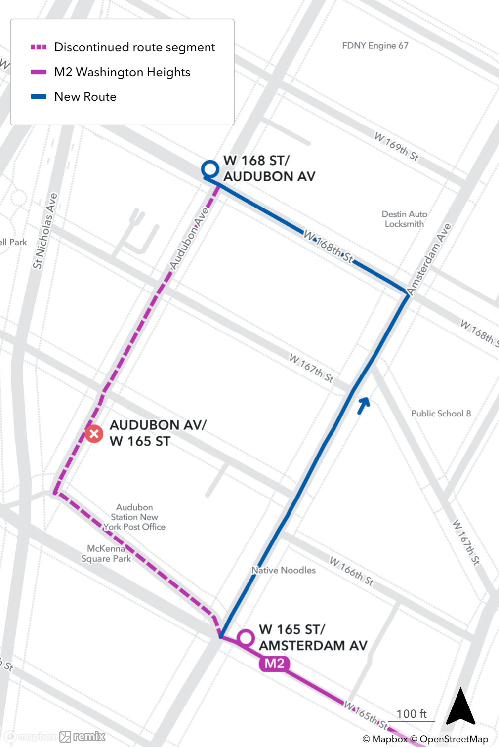
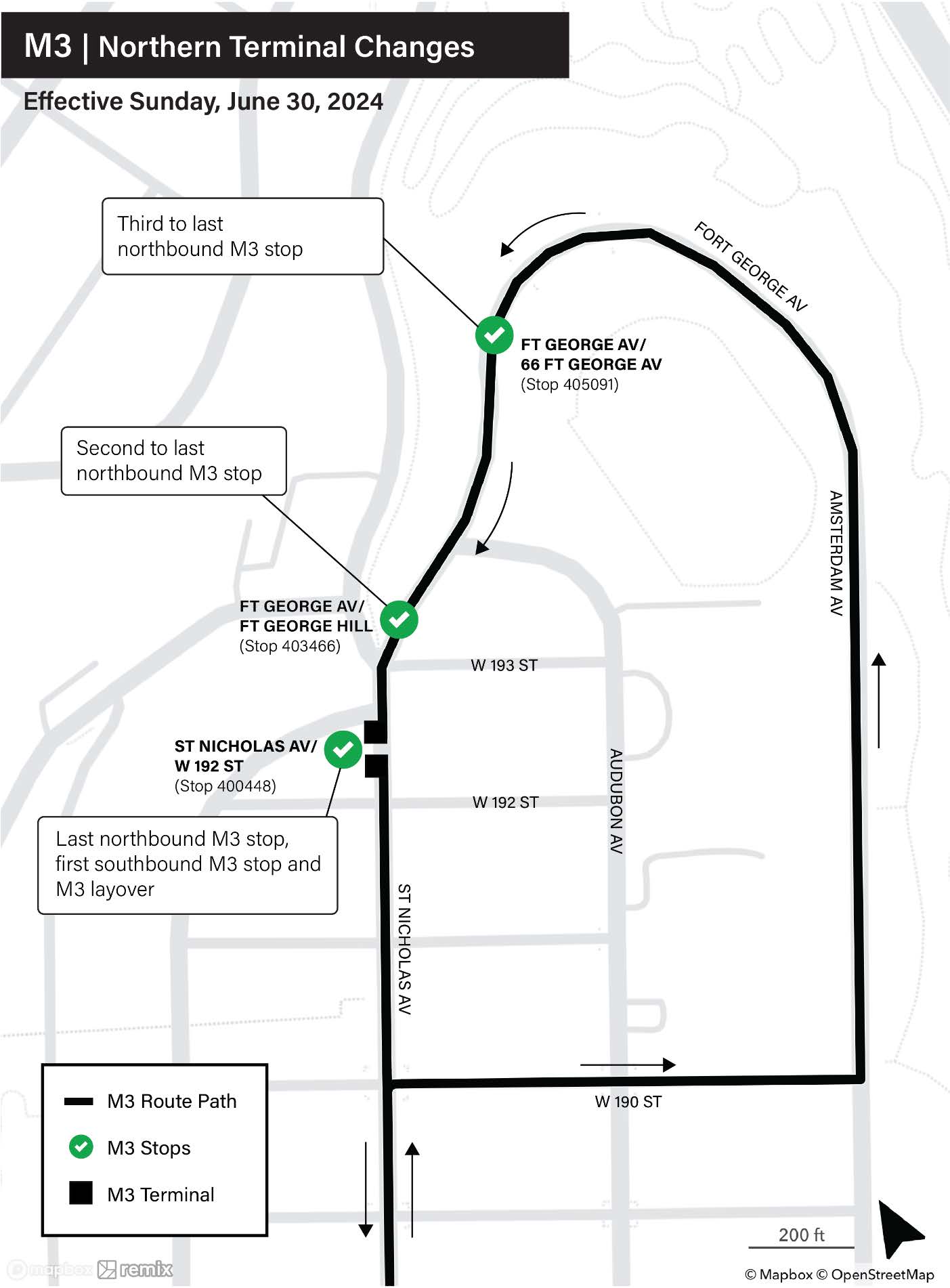
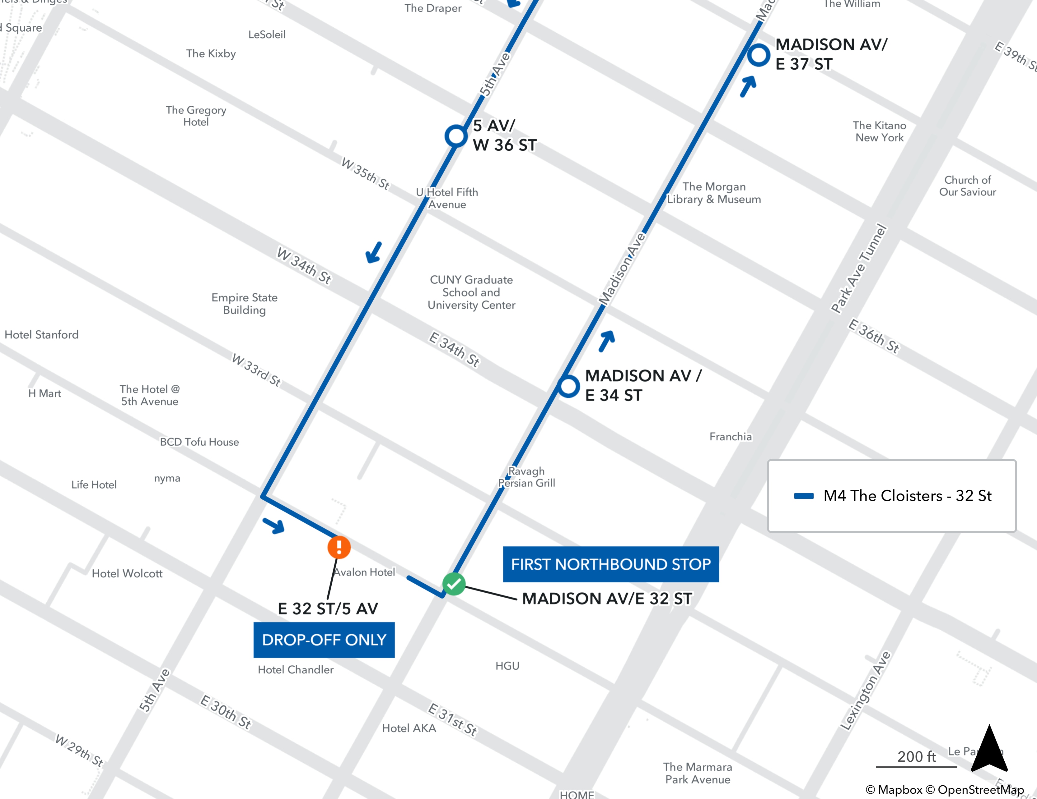
On June 30, 2024, the M2 stop on Audubon Ave at W 165th St was discontinued and was redirected to Amsterdam Avenue,[37] and the M3 stop terminal was relocated to St Nicholas Ave at W 192nd St. [38] The northbound M4 stop on E 32nd St at 5th Ave was relocated to Madison Ave at E 32nd St. The stop on E 32nd St at 5th Ave was changed to be a drop-off only stop.[39]
References
[編輯]- ^ Google Inc. M1 (地圖). Google Inc. May 8, 2017 [May 8, 2017].
- ^ Google Inc. M2 (地圖). Google Inc. May 8, 2017 [May 8, 2017].
- ^ Google Inc. M3 (地圖). Google Inc. May 8, 2017 [May 8, 2017].
- ^ Google Inc. M4 (地圖). Google Inc. May 2, 2024 [May 2, 2024].
- ^ Subway and bus ridership for 2023. mta.info. April 29, 2024 [May 2, 2024].
- ^ 6.0 6.1 MTA Regional Bus Operations. M1 bus schedule.
- ^ MTA Regional Bus Operations. M3 bus schedule.
- ^ MTA Regional Bus Operations. M4 bus schedule.
- ^ GSAPP Historic Preservation Studio 2005-2006. [December 20, 2008]. (原始內容存檔於July 5, 2007).
- ^ Guide to the Fifth Avenue Coach Company Collection, 1895-1962 - Fifth Avenue Coach Company Collection. New York Historical Society. [December 20, 2008].
- ^ Can Extend Its Lines. Brooklyn Daily Eagle (Brooklyn, NY). August 2, 1900: 2.
- ^ Listing of Routes Hit by Strike. The New York Times. March 5, 1962: 47.; Buses Running. The New York Times. March 23, 1962: 21.
- ^ 2 BOROUGHS' BUSES GET NEW NUMBERS. The New York Times. June 20, 1974 [October 2, 2016]. ISSN 0362-4331.
- ^ 1975 Queens Bus Map. wardmaps.com. New York City Transit Authority. 1975 [February 18, 2016].
- ^ Swift Buses Oust Madison Trolleys. The New York Times. February 1, 1935: 23.
- ^ nycsubway.org: Historical Maps. www.nycsubway.org. [2024-08-26].
- ^ One-Way Bus Schedules Given For Lexington and 3d Avenues. The New York Times. July 12, 1960: 37.
- ^ City to Extend One-Way Traffic To 3 Manhattan Routes Sunday. The New York Times. November 5, 1963: 1.
- ^ Stengren, Bernard. 'VILLAGE' TO GET MORE BUS RUNS; 15-an-Hour Scheduling on 5th Ave.-Houston St. Line Will Begin on Sunday. The New York Times. November 8, 1963: 33.
- ^ Kaplan, Samuel. City to Close Washington Square to All Buses; New Routing to Bypass Park Beginning Monday — Traffic Around Square Will Go Counter-Clockwise. The New York Times. August 31, 1963: 1.
- ^ Barnes Suggests Express Bus Runs. The New York Times: 1. January 17, 1966.
- ^ One-Way Avenues Slow Bus Traffic. The New York Times. January 26, 1966: 32.
- ^ "Manhattan and Bronx Surface Transit Operating Authority: The First Ten Years." Motor Coach Age, May 1972.
- ^ Buses on 3 Routes Will Be Expresses During Rush Hour. The New York Times. September 13, 1973 [July 17, 2018].
- ^ M2 & M101 Buses Are Pulling Out The Stops Limited-Stop Service Starts October 14th. New York Daily News. October 11, 1991 [August 17, 2018].
- ^ January 2000 NYC Transit Committee Agenda. New York City Transit Authority. January 18, 2000: 105, 106, 107-108.
- ^ 27.0 27.1 Bus Service Notice. mta.info. Metropolitan Transportation Authority. August 3, 2000 [June 15, 2023]. (原始內容存檔於August 16, 2000).
- ^ March 2000 NYC Transit Committee Agenda. New York City Transit. March 21, 2000: 91, 92, 93-94, 95, 96.
- ^ May 2000 NYC Transit Committee Agenda. New York City Transit. May 16, 2000: 97, 98, 99-100, 101.
- ^ April 2002 NYC Transit Committee Agenda. New York City Transit Authority. April 29, 2002: 89, 90, 91-92, 93.
- ^ Bus Service Notice. mta.info. Metropolitan Transportation Authority. [June 15, 2023]. (原始內容存檔於August 4, 2002).
- ^ MTA | Press Release | NYC Transit | MTA New York City Transit Implements Bus Service Enhancements for 2013. www.mta.info. [October 29, 2016].
- ^ 33.0 33.1 MTA to extend M1 bus route south to Worth St. October 25, 2016 [October 29, 2016].
- ^ New York City Transit and Bus Committee Meeting (PDF). Metropolitan Transportation Authority: 193–196. April 23, 2018 [April 20, 2018].
- ^ New York City Transit and Bus Committee Meeting (PDF). Metropolitan Transportation Authority: 9. May 21, 2018 [April 20, 2018].
- ^ Permanent M4 Route Change in Midtown. web.mta.info. Metropolitan Transportation Authority. July 15, 2018 [July 15, 2018] (英語).
- ^ M2 bus stop relocated.
- ^ M3 bus terminal change.
- ^ M4 bus stop relocated.
External links
[編輯]Template:Manhattan bus routes Template:NYC streetcar transit
Bx12
[編輯]bx12 bx12 | |
|---|---|
| 福德漢姆路-佩勒姆公園路 Fordham Road−Pelham Parkway 207街跨城線 207th Street Crosstown Line | |
 Bx12 SBS上使用的2018 Nova LFSA(5469)和BX12上使用的 2011 Nova LFS(8001)在佩勒姆灣公園車站。 | |
| 概覽 | |
| 所屬系統 | MTA區域巴士營運 |
| 營運公司 | 紐約市公共運輸局 |
| 所屬車廠 | Gun Hill Depot Kingsbridge Depot(僅限夏天的Bx12) |
| 使用車輛 | Nova Bus LFS articulated Nova Bus LFS Nova Bus LFS HEV New Flyer Xcelsior XD40(補充服務) |
| 出租者 | Bx12 SBS: 特選巴士服務 |
| 路線資訊 | |
| 區域 | 紐約市布朗克斯與曼哈頓 |
| 社區服務 | Inwood, University Heights, Fordham, Belmont, Allerton, Morris Park, Pelham Gardens, Pelham Bay, Baychester, Co-op City |
| 地標服務 | Fordham Plaza, Fordham University, New York Botanical Garden, Bronx Zoo, Pelham Bay Park, Bay Plaza Shopping Center, Orchard Beach |
| 起點站 | Inwood – Broadway / 207th Street (full route) University Heights – Sedgwick Avenue (daytime local) |
| 途經 | 207th Street, Fordham Road, Pelham Parkway |
| 終點站 | Pelham Bay Park (daytime local) Orchard Beach (summertime local) Baychester – Edson Avenue (late night) Bay Plaza Shopping Center (full route)[note 1][1] |
| 行駛距離 | 8.2英里(13.2公里)[2] |
| 服務日期 | 24小時(Bx12 本地服務)[note 1][note 2][1][3] |
| 每年贊助 | 5,900,063 (2023)[4] |
| 時間表 | Bx12 Bx12 SBS |
Bx12是紐約市的一條公交線路,沿曼哈頓和布朗克斯內的207街跨城線(又稱福特漢姆路-207街跨城線[5]或福特漢姆路跨城線[6])運行。該線路沿曼哈頓上城的207街以及布朗克斯連續的福特漢姆路和佩勒姆公園路運行。
該線路於20世紀初開始運營,當時是曼哈頓英伍德和布朗克斯貝爾蒙特之間的一條有軌電車線路。[5][7]1948年,這條有軌電車線路被改造成一條巴士線路,由紐約市交通運輸管理局下屬的曼哈頓和布朗克斯地面交通運營局 (MaBSTOA) 運營。在整個 20 世紀末,幾條獨立的公交線路合併成了Bx12。2008年,Bx12 Limited(Bx12限站服務) 更名為Bx12 SBS,成為該市第一條投入運營的巴士快速交通系統線路。Bx12和Bx12 SBS每周工作日的乘客量均超過45000人/次。到2023年,總乘客量將達到5,900,063人/次,成為全市第四繁忙的線路,僅次於B6、Q58和M15。[4]這條線路經常被列為改建為輕軌的候選線路。
線路說明和服務
[編輯]目前的巴士服務
[編輯].jpg)
Bx12 線路從曼哈頓因伍德穿越城鎮前往布朗克斯東北部的各個地區。該線路向東的起點是位於百老匯和西 207 街的因伍德-207 街地鐵站(A 線) 。然後,Bx12繞行伊沙姆街和謝爾曼大道,重新回到西 207 街,繼續穿過大學高地大橋進入大學高地。路線沿福特漢姆路穿過福特漢姆中心、福特漢姆廣場和貝爾蒙特,直到布朗克斯公園的布朗克斯動物園和紐約植物園附近的佩勒姆公園路。然後,線路沿着佩勒姆公園路的主幹道延伸至佩勒姆灣,在那裡線路有些迂迴。該線路從佩勒姆公園路轉入伯爾大道,在佩勒姆灣公園地鐵站停靠。從這裡開始,不以這裡為終點站的 Bx12 線路會調頭,加入新英格蘭高速公路,前往海灣廣場,或沿海岸路向東行駛,前往奧查德海灘。
Bx12從曼哈頓的英伍德橫穿至布朗克斯東北部的多個地區。該線路向東開始於百老匯和西207街交匯處的英伍德-207街車站。然後經艾沙姆街和謝爾曼大道繞行,重新回到西207街,繼續穿過大學高地橋進入大學高地。線路沿福特漢姆路行駛,經過福特漢姆中心、福特漢姆廣場和貝爾蒙特,直到布朗克斯公園的布朗克斯動物園和紐約植物園附近的佩勒姆公園路。接着,線路沿佩勒姆公園路的主幹道行駛至佩勒姆灣,在這裡走一段相對迂迴的路線。線路從佩勒姆公園道轉入伯爾大道,在佩勒姆灣公園車站停靠。從這裡,不以這裡為終點站的Bx12服務會掉頭並駛入新英格蘭快速路前往海灣廣場,或沿海濱路向東駛向果園海灘(Orchard Beach)。[1][3][8]
在佩勒姆海灣公園站,曼哈頓方向的巴士沿阿門多拉巷南行線停靠。這種設置要求西行班次在駛入佩勒姆公園路之前,必須在海濱路上掉頭。[9][10]
During the daytime and evening hours, local service runs between Sedgwick/Webb Avenue in University Heights and the Pelham Bay Park subway station (6 與<6> 線). Some local service also originates from Belmont Avenue and 182nd Street in Belmont during the afternoons on school days. Most service between Manhattan and Bay Plaza is served by Bx12 Select buses during that time, although some local buses continue to Bay Plaza. During the summer, Bx12 local buses are extended to Orchard Beach, with all weekend service operating to/from Inwood during the summer.[1][3][8]
During the overnight hours, all service runs local, serving the entire route with the exception of Bay Plaza. Buses instead terminate on Edson Avenue, in front of the Gun Hill Bus Depot, as the shopping center is closed during these times.[1][3]
Select Bus Service
[編輯]
The Bx12 is New York City's first bus rapid transit service, marketed as Select Bus Service, which began on June 29, 2008. Selected as the Bronx corridor for the pilot project in 2004, the MTA, New York City Department of Transportation (NYCDOT) and the New York State Department of Transportation (NYSDOT) drew up plans to convert the Bx12's limited service to BRT. The route was selected for the project mainly because of its mostly straight crosstown route through the Bronx, intersecting with seven different subway lines and all Metro-North lines.}[11][3][12][13][14]

Buses are outfitted with special identification (including a special blue wrap and blue route signs) and traffic signal prioritization was enacted along the route, timing traffic signals in favor of the bus. When supplemental service is needed, the blue wrap may be absent. The NYCDOT also added dedicated bus lanes painted in maroon-red along Pelham Parkway and Fordham Road, with signs indicating that the lanes are bus-only from 7:00 am to 7:00 pm on weekdays, along with additional police enforcement. Off-board fare collection, via MetroCard fare machines and coin meters, allows passengers with proof of payment to board through any door. Bx12 Select Bus Service operates daily, from around 6am to 10pm weekdays, 7am-11pm weekends.[11][3][12][13][14]
Stops
[編輯]
History
[編輯]Streetcar service
[編輯]The Fordham Road/Pelham Parkway service began as a streetcar line operated by the Union Railway Company, a subsidiary of the Third Avenue Railway, and was the last Union Railway franchise to be constructed.[5][15] In February 1903, the company announced plans to construct a two-track line along Pelham Avenue (the former name of Fordham Road and Pelham Parkway) between Bronx Park and Pelham Bay Park, running through largely undeveloped land and parkland. Called the Pelham Avenue Line, its western terminus would be at Third Avenue in modern Fordham Plaza, at the Fordham station of the then-New York Central Railroad (now the Metro-North Railroad Harlem Line) and the entrance of what was then St. John's College (now Fordham University's Rose Hill campus). Its eastern end would be at the Pelham Bridge in Pelham Bay.[16][17]
By 1904, the line was running along Fordham Avenue and Pelham Avenue (today's Fordham Road) between Sedgwick Avenue in University Heights and Third Avenue in Fordham.[18] That year, the company released plans to extend the line west across the yet-to-be-constructed University Heights Bridge to Broadway and 207th Street in Inwood, Manhattan.[18][19] By fall 1908, after the opening of the bridge, the Union Railway petitioned for an extension west to Manhattan, and east to Pelham Bay Park.[20] By 1909, the planned eastern extension was truncated to Southern Boulevard, with both extension plans delayed due to deadlock in negotiations with the city.[21] In 1910, the company once again petitioned the New York City Board of Estimate and the New York State Public Service Commission for a western extension to Manhattan, and for an eastern extension from Southern Boulevard to the eastern edge of Bronx Park (at about Boston Road, White Plains Road, and Bronx Park East).[22][23] The Manhattan extension was finally granted in June 1910.[24][25] Service across the bridge to Inwood began on November 29, 1910.[24]
In late 1916, the railway petitioned for another extension along either Vermilyea Avenue or Nagle Avenue, and Dyckman Street west to the ferry terminal at the end of Dyckman Street, to connect with ferries to New Jersey and upstate New York, particularly the Palisades region and Palisades Interstate Park.[5][26][27][28] The franchise was granted in December of that year.[26][29] The extension was initially opposed since many streets in the area were narrow.[26] Later, the Union Railway sought to annul the franchise agreement, which was opposed by the local Dyckman (Inwood/Washington Heights) community due to growing business interests created by the line.[27][28] The extension was never implemented.[30]
Conversion to bus service
[編輯]
Beginning in the 1920s, many streetcar lines in the Bronx, Manhattan, and the rest of the city began to be replaced by buses, particularly after the unification of the city's three primary transit companies in June 1940.[31][32][33] That year, the railroad company began relinquishing its trolley franchises with the city, to be replaced by buses operated by the subsidiary Surface Transportation Corporation.[15][34] The 207th Street Crosstown Line was replaced with the then-Bx19 bus service operating between Broadway-207th Street and Southern Boulevard on January 25, 1948, the same date as the motorization of the Bronx and Van Cortlandt Parks Crosstown Line (today's Bx9).[30] The route would be operated by Surface Transit until 1956, and by the New York City Omnibus Corporation (later under the brand Fifth Avenue Coach Lines) until the company's routes were taken over by the New York City Transit Authority through its subsidiary Manhattan and Bronx Surface Transit Operating Authority (MaBSTOA) in 1962 after a strike.[35]
As the years progressed, service was eventually consolidated from multiple routes, and was given a single label, the Bx12. The route saw extensions east to City Island, seasonal service to Orchard Beach, and a branch to the Bartow-Pell Mansion in the Pelham Bay Golf Course,[36] along with the introduction of limited-stop service on weekdays. The Orchard Beach branches were labeled Bx12A and Bx12B until July 1, 1974, when they were merged into the Bx12 designation.[37]
On April 21, 1989, the New York City Transit Authority presented two proposals to rationalize the eastern terminals of service on the Bx12 to the MTA Board for approval. The first proposal called for the discontinuation of the summer only Bx12 Golf Course Shuttle, which ran between Orchard Beach and Pelham Bay Golf Course between 8 a.m. and 6 p.m., since it was only used by an average of ten daily passengers. This change took effect in June 1989. The second proposal up for approval was the extension of Bx12 trips that terminated at the Pelham Bay Park subway station to the new Gun Hill Depot at Bartow Avenue and the New England Thruway when it opened in September 1989. This change was intended to rationalize service and establish a relief point for bus operators. While it increased net costs, it increased operating efficiencies.[38] In early 1990, the MTA proposed a dedicated route from City Island to Pelham Bay, the current Bx29.[39][40] The Bx12 continued to run to City Island through mid-1990,[41] but the bus routes were split by 1991.[42] The split service pattern remains in effect today, with some minor adjustments.[43]
In 1988, due to the reconstruction of the University Heights Bridge, the Bx12 began detouring 0.5英里(0.80公里) to cross into Manhattan via Bailey Avenue and the Broadway Bridge at 225th Street, as opposed to the direct path via 207th Street. The route was restored in September 1994 as the vehicle weight restriction on the bridge was removed.[44] In 1989, limited-stop service began on the Bx12, saving up to five minutes per trip. In January 1995, an additional limited stop was added at Jacobi Hospital, and the hours of limited-stop service were expanded from 6:57 – 8:39 a.m. and 4:55 – 6:41 p.m. to 6:30 – 9:30 a.m. and 4 – 6:30 p.m.. Extending the span of the limited-stop service to operate all day between 7 a.m. and 7 p.m. was considered, with a plan to revisit the idea if the increase in the span of limited-stop service was successful.[45] The span of the Bx12 was extended to operate all day between 6:30 a.m. and 7 p.m. on September 8, 1997.[46] Exactly one year later, on September 8, 1998, the Bx12 began stopping in the Bay Plaza Shopping Center.[47]

In 2004, the MTA in conjunction with the NYCDOT and NYSDOT, performed an initial study on bus rapid transit, with 80 corridors studied citywide. Five routes were prioritized, including the Bx12 route.[11][48][49][50] On June 29, 2008, the Bx12 Limited was converted into the Bx12 Select Bus Service.[11][12][13][14] Initially, during summer months Bx12 SBSs alternated between Bay Plaza and Orchard Beach. In 2009, Bx12 locals were extended to Orchard Beach during summer months, with all SBSs terminating at Bay Plaza. Summer local service to Inwood was also added at this time.[8] The total ridership in 2009 was 14,736,515, ranking the route third in ridership citywide and the busiest in the Bronx.[51] In March 2013, the high-floor articulated buses on the SBS route were replaced with low-floor articulated buses with three sets of doors to improve boarding and alighting of passengers.[52]
Notes
[編輯]References
[編輯]- ^ 1.0 1.1 1.2 1.3 1.4 MTA Regional Bus Operations. Bx12 bus schedule.
- ^ Bx12 WB. Google Maps. Feb 11, 2024 [2024-02-11] (英語).
- ^ 3.0 3.1 3.2 3.3 3.4 3.5 MTA Regional Bus Operations. Bx12 SBS bus schedule (PDF).
- ^ 4.0 4.1 Subway and bus ridership for 2023. mta.info. April 29, 2024 [May 2, 2024].
- ^ 5.0 5.1 5.2 5.3 New Roads and Projects. Railway Review. 1918, 62: 489 [March 4, 2016]. (原始內容存檔於June 27, 2022).
- ^ New York State Legislature. Report on the Traction Situation In New York City By The Public Service Commission for the First District In response to a concurrent resolution passed by both Houses of the Legislature of 1920, calling upon the Public Service Commissioner for the results of his investigation and information as to whether it is possible for the traction companies to give adequate service at the present rate of fare. 1920: 115 [March 5, 2016]. (原始內容存檔於June 27, 2022).
- ^ The Real Estate Field (PDF). The New York Times. October 27, 1914 [September 2, 2009]. (原始內容存檔 (PDF)於June 27, 2022).
- ^ 8.0 8.1 8.2 Bx12 Local to Orchard Beach Will Start from Inwood on Weekends. Metropolitan Transportation Authority. July 2, 2009 [March 4, 2016]. (原始內容存檔於March 6, 2016).
- ^ MTA Bus Time: Bx12 Pelham Pkwy - Fordham Rd via Pelham Pkwy / Fordham Rd. mta.info. Metropolitan Transportation Authority. [March 6, 2016]. (原始內容存檔於November 7, 2015).
- ^ MTA Bus Time: Bx12-SBS Pelham Pkwy - Fordham Rd Select Bus Service via Pelham Pkwy / Fordham Rd / Bay Plaza Shop Ctr. mta.info. Metropolitan Transportation Authority. [March 6, 2016]. (原始內容存檔於November 7, 2015).
- ^ 11.0 11.1 11.2 11.3 Select Bus Service on the Bx12: A BRT Partnership Between the New York City DOT and MTA New York City Transit (PDF). Metropolitan Transportation Authority, New York City Department of Transportation. January 12, 2009 [March 4, 2016]. (原始內容存檔 (PDF)於October 3, 2016).
- ^ 12.0 12.1 12.2 Neuman, William. Riders Will Pay Before Boarding, and Save Time, on Revamped Bus Route. The New York Times. June 29, 2008 [September 2, 2009]. (原始內容存檔於September 25, 2020).
- ^ 13.0 13.1 13.2 Bx12 Select Bus Service One Year Report (PDF). Metropolitan Transportation Authority. October 2009 [January 8, 2016]. (原始內容存檔 (PDF)於March 4, 2016).
- ^ 14.0 14.1 14.2 A Bronx Tale: Bus Rapid Transit in New York City. Metropolitan Transportation Authority, New York City Department of Transportation. [January 8, 2016]. (原始內容存檔於March 4, 2016).
- ^ 15.0 15.1 Third Avenue Line Must Run Buses: Last Hearing on Contract Set for September 12. (PDF). The Sun (New York). July 26, 1940: 10 [March 6, 2016] –透過Fultonhistory.com.
- ^ Bronx and Pelham Parks Will Be United by a New Trolley Line: Union Railway to Exercise Its Last Unused Franchise in the Construction of This Route-Consents of Property Owners Now Being Sought (PDF). New York Herald. Fultonhistory.com. February 8, 1903: 2 [March 6, 2016]. (原始內容存檔 (PDF)於June 27, 2022).
- ^ For New Trolley In The Bronx: Interurban Intends to Connect Bronx and Pelham Parks with Electric Line (PDF). New York Press (historical). Fultonhistory.com. February 9, 1903: 8 [March 6, 2016].
- ^ 18.0 18.1 Union Railway Plans To Enter Manhattan: Petitions for Franchises to Effect Thirteen Connections. (PDF). The New York Times. February 24, 1904 [December 24, 2015]. (原始內容存檔 (PDF)於January 21, 2022).
- ^ Huckleberry Asks To Extend: Franchises for 13 New York Lines Applied For-Crossing Four Harlem River Bridges and Linking Upper Borough Surface Roads With Subway and Metropolitan Lines-Ready to Share Bridge Tracks (PDF). The New Rochelle Press. February 27, 1904: 7 [March 6, 2016] –透過Fultonhistory.com.
- ^ Cars Across New Bridger: Third Avenue Line Allowed to Ask For Franchises (PDF). The Sun (New York). September 16, 1908: 13 [March 6, 2016]. (原始內容存檔 (PDF)於June 27, 2022) –透過Fultonhistory.com.
- ^ Board Holds Up Pelham Franchise (PDF). The New York Times. April 5, 1909 [March 6, 2016]. (原始內容存檔 (PDF)於June 27, 2022).
- ^ Public Notices; City of New York; Board of Estimate and Apportionment (PDF). The Sun (New York). March 17, 1910: 12 [March 6, 2016]. (原始內容存檔 (PDF)於June 27, 2022) –透過Fultonhistory.com.
- ^ Union Trolley Extension. (PDF). The New York Times. July 24, 1910 [March 6, 2016]. (原始內容存檔 (PDF)於June 27, 2022).
- ^ 24.0 24.1 University Heights Bridge (PDF). Historic American Engineering Record. [March 6, 2016]. (原始內容存檔 (PDF)於September 10, 2016).
- ^ Moses, Charles Griffith. Possibilities of the Dyckman Section of Manhattan Island (PDF). New York Herald. July 24, 1910: 2 [March 6, 2016]. (原始內容存檔 (PDF)於June 27, 2022) –透過Fultonhistory.com.
- ^ 26.0 26.1 26.2 Dyckman Against Trolley (PDF). The Sun (New York). Fultonhistory.com. October 15, 1916: 15 [March 6, 2016]. (原始內容存檔 (PDF)於June 27, 2022).
- ^ 27.0 27.1 Dyckman Trolley Fight: Upper City Interests Oppose Union Railway's Effort Not to Build Extension to Ferry (PDF). New York Evening Post. Fultonhistory.com. June 8, 1918: 11 [March 6, 2016]. (原始內容存檔 (PDF)於June 27, 2022).
- ^ 28.0 28.1 Want Dyckman Line: Washington Heights Protests Against Canceling Car Franchise (PDF). The New York Times. June 2, 1918 [March 6, 2016]. (原始內容存檔 (PDF)於June 27, 2022).
- ^ Trolley for the Dyckman (PDF). The Sun (New York). Fultonhistory.com. December 24, 1916: 11 [March 6, 2016]. (原始內容存檔 (PDF)於June 27, 2022).
- ^ 30.0 30.1 Buses To Replace 2 Trolley Lines: The Bronx-Van Courtland Park and 207th St. Crosstown to Shift on Jan. 25 (PDF). The New York Times. January 8, 1948 [March 6, 2016]. (原始內容存檔於June 27, 2022).
- ^ Sparberg, Andrew J. From a Nickel to a Token: The Journey from Board of Transportation to MTA. Fordham University Press. October 1, 2014: 111. ISBN 978-0-8232-6190-1.
- ^ Seyfried, Vincent F. Story of the Long Island Electric Railway and the Jamaica Central Railways, 1894-1933. archive.org. F. E. Reifschneider. 1961 [December 20, 2015].
- ^ Trolley Cars Here On Way To Oblivion By Next Year's End: 700 New Buses to Assume Travel Burden on Lines in Manhattan and Bronx (PDF). The New York Times. September 15, 1945 [December 24, 2015]. (原始內容存檔於June 27, 2022).
- ^ Record Bus Grant Signed By Mayor: Motor Transit Will Replace Street Cars on Routes in Manhattan and Bronx (PDF). The New York Times. November 10, 1940 [March 6, 2016]. (原始內容存檔於June 27, 2022).
- ^ Kenneth T. Jackson; Lisa Keller; Nancy Flood. The Encyclopedia of New York City: Second Edition. Yale University Press. December 1, 2010. ISBN 978-0-300-18257-6.
- ^ 1974 Bronx Bus Map. wardmaps.com. New York City Transit Authority. 1974 [March 3, 2016]. (原始內容存檔於March 10, 2016).
- ^ 2 Boroughs' Buses Get New Numbers. The New York Times. June 20, 1974: 9 [October 2, 2016]. ISSN 0362-4331. (原始內容存檔於August 1, 2017).
- ^ Transit Authority Committee Agenda Friday, April 21, 1989. New York City Transit Authority. April 21, 1989: J-9, J-10, J-11, J-12, J-13, J-14, J-15.
- ^ Notice of Public Hearing. Daily News. 1990-02-05: 127 [2021-01-22]. (原始內容存檔於June 27, 2022).
- ^ Winiarski, Kathryn. Residents of City Island protest bus plan. The Herald Statesman. 1990-03-12: 2 [2021-01-22]. (原始內容存檔於June 27, 2022).
- ^ Perlow, Maris. City Island. Daily News. 1990-06-01: 238 [2021-01-22]. (原始內容存檔於June 27, 2022).
- ^ New York's Enchanted Island. Daily News. 1991-07-19: 49 [2021-01-22]. (原始內容存檔於June 27, 2022).
- ^ Bronx Bus Map (PDF). Metropolitan Transportation Authority. September 2017 [April 24, 2018].
- ^ NYC Transit Committee Agenda June 1994. New York City Transit. June 10, 1994: D.97, D.98, D.99, D.100.
- ^ NYC Transit Committee Agenda September 1994. New York City Transit. September 16, 1994: D.62, D.63, D.64.
- ^ Bus Service Notices. mta.nyc.ny.us. January 14, 1998 [February 3, 2019]. (原始內容存檔於January 27, 1998).
- ^ Starting September 8th, the Bx12 bus will make stops inside the Bay Plaza Shopping Center. How's that for convenience?. New York Daily News. September 4, 1998 [August 17, 2018]. (原始內容存檔於August 18, 2018).
- ^ Bus Rapid Transit: NYCBRT Study (PDF). Metropolitan Transportation Authority, New York City Department of Transportation, New York State Department of Transportation. 2004 [February 15, 2016]. (原始內容 (PDF)存檔於May 12, 2005).
- ^ Map of BRT ideas in New York City. [July 1, 2008]. (原始內容存檔於June 16, 2011).
- ^ MTA Planning – NYC Select Bus Service. mta.info. Metropolitan Transportation Authority. [July 1, 2008]. (原始內容存檔於November 17, 2013).
- ^ Bus Ridership: MTA New York City Transit. mta.info. Metropolitan Transportation Authority. (原始內容存檔於July 8, 2012).
- ^ MTA NYC Transit Introduces New Articulated Bus into SBS service; Three Doors – Less Waiting. mta.info. Metropolitan Transportation Authority. March 14, 2013 [March 4, 2016]. (原始內容存檔於March 6, 2016).