
丹尼爾森隕擊坑
 顯示了丹尼爾森撞擊坑和附近其他的隕石坑的火星軌道器激光高度計測繪圖。顏色表示海拔高度,丹尼爾森撞擊坑位於右上方。 | |
| 行星 | 火星 |
|---|---|
| 區域 | 歐克西亞沼區 |
| 坐標 | 7°56′N 7°07′W / 7.93°N 7.11°W座標:7°56′N 7°07′W / 7.93°N 7.11°W |
| 火星方格列表 | 奧克夏沼區 |
| 直徑 | 66.7 公里 |
| 命名 | 愛德華·丹尼爾森 |
丹尼爾森隕擊坑(Danielson Crater)是火星歐克西亞沼區的一座撞擊坑,它位於子午線高原以北、阿拉伯高地以南、火星子午線的西面。它的中心坐標為北緯7.93度、西經7.11度,直徑約66.7公里,其名稱取自美國工程師愛德華·丹尼爾森(英語:G. Edward Danielson),2009年被國際天文聯合會正式批准接受[1][2]。
.jpg)
該隕擊坑的許多特寫照片都揭示了它的多重薄岩層,其中一些已被斷層破壞,丹尼爾森坑坑底岩層可能形成於湖底[3][4][5]。
圖集[編輯]
-
 火星勘測軌道飛行器背景相機拍攝到的丹尼爾森隕擊坑的西側,顯示了很多規則的岩層。
 -
 在這張背景相機圖像中,可以看到丹尼爾森隕擊坑的部分岩層和沙丘。
 -
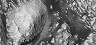
 火星勘測軌道飛行器背景相機拍攝到的丹尼爾森隕擊坑的東側,這裏有許多岩層,但幾乎看不清。
 -
 火星勘測軌道飛行器背景相機拍攝到的丹尼爾森隕擊坑岩層。註:這是前面隕坑東側照片的放大版。
 -
 高解像度成像科學設備看到的丹尼爾森隕擊坑的岩層,在頂部可看見塵暴痕跡。
 -
 在這張高解像度成像科學設備圖像中可看到許多岩層,暗色塵埃更突出了一些岩層。
 -
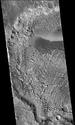
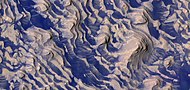
 HiWish計劃下高解像度成像科學設備看到的丹尼爾森隕擊坑各岩層全景圖,方框顯示了下一幅圖像的位置,圖像中的暗黑部分是分佈於平坦表面的黑色玄武岩砂。
 -
 顯示了丹尼爾森隕擊坑先前圖像中斷層和岩層的放大版,訪圖像由高解像度成像科學設備根據HiWish計劃拍攝。
 -
 HiWish計劃下的高解像度成像科學設備拍攝的丹尼爾森隕擊坑部分區域全景圖
 -
 HiWish計劃下高解像度成像科學設備顯示的丹尼爾森隕擊坑放大圖。方框代表足球場大小的區域。
 -
 HiWish計劃下高解像度成像科學設備顯示的丹尼爾森隕擊坑岩層特寫圖,可以看到巨礫和黑色沙粒。
 -
 HiWish計劃下高解像度成像科學設備顯示的丹尼爾森隕擊坑中的岩層,在圖像上部顯示了塵暴痕跡。
 -
 HiWish計劃下高解像度成像科學設備顯示的丹尼爾森隕擊坑岩層彩色特寫。
 -
 HiWish計劃下高解像度成像科學設備顯示的丹尼爾森隕擊坑中的岩層和岩丘。
 -
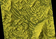 HiWish計劃下高解像度成像科學設備顯示的丹尼爾森隕擊坑中的岩層彩色特寫。


-
 HiWish計劃下高解像度成像科學設備顯示的丹尼爾森隕擊坑岩層全景圖。
 -
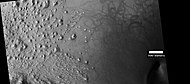
 LHiWish計劃下高解像度成像科學設備顯示的丹尼爾森隕擊坑岩層,附帶有比例尺。
 -
 HiWish計劃下高解像度成像科學設備顯示的丹尼爾森隕擊坑中的岩層和深色塵埃。
 -
 HiWish計劃下高解像度成像科學設備顯示的丹尼爾森隕擊坑底部的岩層、隕坑和土墩。
 -
 HiWish計劃下高解像度成像科學設備顯示的丹尼爾森隕擊坑底部的隕石坑近景。
 -
 HiWish計劃下高解像度成像科學設備顯示的丹尼爾森隕擊坑地面上的層狀土墩。
 -
 HiWish計劃下高解像度成像科學設備拍攝到的丹尼爾森隕擊坑地面上的岩層和深色塵埃彩色近景圖。
 -
 HiWish計劃下高解像度成像科學設備拍攝的丹尼爾森隕擊坑地面上的岩層和深色塵埃彩色近景圖,在圖像中可看到巨石。
 -
 HiWish計劃下高解像度成像科學設備拍攝的丹尼爾森隕擊坑地面上的岩層和深色塵埃彩色近景圖,箭頭指示出斷層。
 -
 HiWish計劃下高解像度成像科學設備拍攝的丹尼爾森隕擊坑底部岩層近景,在圖中可看到一些斷層。
 -
 HiWish計劃下高解像度成像科學設備拍攝的丹尼爾森隕擊坑坑底上岩層和深色塵埃的彩色近景圖,在圖中可看到一些小斷層。


另請查看[編輯]
參考文獻[編輯]
- ^ Edgett, Ken. The Martian Craters Asimov and Danielson. The Planetary Society. May 27, 2009 [2017-11-06]. (原始內容存檔於2017-11-07).
- ^ Gazetteer of Planetary Nomenclature | Danielson. usgs.gov. International Astronomical Union. [5 March 2015]. (原始內容存檔於2021-08-07).
- ^ Cabrol, N. and E. Grin. 2001. The Evolution of Lacustrine Environments on Mars: Is Mars Only Hydrologically Dormant? Icarus: 149, 291-328.
- ^ Fassett, C. and J. Head. 2008. Open-basin lakes on Mars: Distribution and implications for Noachian surface and subsurface hydrology. Icarus: 198, 37-56.
- ^ Fassett, C. and J. Head. 2008. Open-basin lakes on Mars: Implications of valley network lakes for the nature of Noachian hydrology.