
普羅克特隕擊坑
 海盜1號軌道器拍攝的拼接圖 | |
| 行星 | 火星 |
|---|---|
| 區域 | 諾亞高地 |
| 坐標 | 48°00′S 330°30′W / 48°S 330.5°W座標:48°00′S 330°30′W / 48°S 330.5°W |
| 火星方格列表 | 挪亞區 |
| 命名 | 理查德·安東尼·普羅克托 |
普羅克特隕擊坑(Proctor)是坐落於火星挪亞區的一座撞擊坑,其中心坐標位於南緯48度、西經330.5度處,直徑168.2公里。該特徵取名自英國天文學家理查德·安東尼·普羅克托(1837年-1888年),1973年被國際天文聯合會行星系統命名工作組批准接受[1]。
沙丘場[編輯]
該隕坑中分佈有一片35x65公里大小的黑色沙丘區[2][3],它是在水手9號圖像中發現的首批火星沙丘區域之一[4]。高解像度成像科學設備正在監測這一沙丘,以確定其隨時間所發生的變化[5]。
-
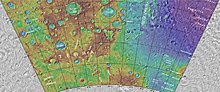 顯示了普羅克托隕擊坑和附近其他隕坑位置的地形圖。
 -
 另一幅海盜號拍攝的普羅克托坑內沙丘和周邊隕石坑丘照片。
 -
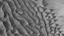
 高解像度成像科學設備顯示的橫向風成脊,周圍是大片的沙丘。
 -
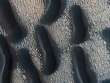 普羅克托坑底黑色沙丘的邊緣。
 -
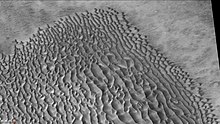 火星勘測軌道飛行器背景相機拍攝的普羅克特坑內沙丘場。
 -
 普羅克托坑底沙丘特寫,這是放大的前一照片中的部分區域。


另請查看[編輯]
參考文獻[編輯]
- ^ Gazetteer of Planetary Nomenclature | Proctor. usgs.gov. International Astronomical Union. [4 March 2015]. (原始內容存檔於2022-05-05).
- ^ Fenton, L. K. Seasonal Movement of Material on Dunes in Proctor Crater, Mars: Possible Present-Day Sand Saltation (PDF). Lunar and Planetary Science XXXVI (2005). 2005 [2022-05-05]. (原始內容 (PDF)存檔於2021-08-05).
- ^ Mary Chapman (編). The Geology of Mars: Evidence from Earth-Based Analogs. Cambridge University Press. 2007: 250. ISBN 978-0-521-83292-2.
- ^ Dune Activity in Proctor Crater. Mars Global Surveyor - Mars Orbiter Camera - MGS MOC Release No. MOC2-170. Malin Space Science Systems. 10 August 1999 [2022-05-05]. (原始內容存檔於2022-05-05).
- ^ Bridges, Nathan. Sand Dunes and Ripples in Proctor Crater. HiRISE Operations Center. 9 March 2009 [2022-05-05]. (原始內容存檔於2021-03-05).
外部連結[編輯]
 維基共享資源上的相關多媒體資源:普羅克特隕擊坑
- Nemiroff, Robert; Bonnell, Jerry. 火星沙丘. 今日天文圖片(APOD). February 26, 2002 [2022-05-05]. (原始內容存檔於2021-03-28).
| 這是一篇關於火星或其衛星的小作品。你可以透過編輯或修訂擴充其內容。 |
| 這是一篇與天文學相關的小作品。你可以透過編輯或修訂擴充其內容。 |