機井洞
外觀
| 機井洞 | |
 | |
| 韓語名稱 | |
|---|---|
| 諺文 | 기정동 |
| 漢字 | 機井洞[1] |
| 文觀部式 | Gi Jeong Dong |
| 馬-賴式 | Ki Jŏng Dong |
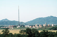
機井洞是朝鮮民主主義人民共和國開城市板門區域平和里(朝鮮語:평화리/平和里*/?)[1]的一個洞。該洞位於朝韓非軍事區(DMZ)北方境內。[2]機井洞被朝鮮稱為平和村(韓語:평화촌/平和村 p'yŏnghwach'on)[3],而西方國家和韓國媒體則稱之為宣傳村(韓語:선전마을/宣傳마을 seonjeon maeul)[4][5][6][7][2]。
根據朝鮮停戰協定,韓戰休戰,設立4公里寬的非軍事區,該區中僅允許兩座村莊存在:朝鮮的機井洞[6][8]和韓國的臺城洞[8],兩村距離約2.22公里(1.38英里)遠。
村子的坐標是37.941761N, 126.653430E.。
歷史
[編輯]
朝鮮政府稱機井洞是擁有200家庭的集體農場,擁有幼兒園和中小學網、醫院。[9]韓國方面則稱機井洞是1950年所建設無人居住的宣傳村莊,用來誘使韓國人投靠,村子中居住的是朝鮮人民軍,負責維護邊境上眾多的軍事設施碉堡和地下掩體。[2][3][10][11]
旗杆
[編輯]1980年代,韓國政府在臺城洞建設了一個98.4米(323英尺)高的旗杆,上面有一面重130公斤(287磅)的韓國國旗。
不久之後,朝鮮政府建設了更高的板門店旗杆,且是當時世界第一高的旗杆,高達160米(525英尺),上面的朝鮮國旗重270公斤(595磅)。旗杆距離邊境1.2 km(0.7 mi)(37°56'30.24"N, 126°40'48.07"E),被韓國方面稱為戰爭旗杆。[10][12][13]直到2010年,被阿塞拜疆高162米(531英尺)的巴庫國家旗杆廣場旗杆超越。
圖庫
[編輯]-
機井洞
-
機井洞
-
機井洞全景+旗杆 (37°56'30.24"N, 126°40'48.07"E)
參見
[編輯]參考資料
[編輯]- ^ 1.0 1.1 기정동(機井洞)[트느피마을, 틀늪]. 북한지역정보넷 (North Korean Human geography). Galhyeon-dong, Seoul: 평화문제연구소. 2007-12-08 [2010-04-11]. (原始內容存檔於2011-12-17) (韓語).
- ^ 2.0 2.1 2.2 Tran, Mark. Travelling into Korea's demilitarised zone: Run DMZ. The Guardian (London: Guardian Media Group). 2008-06-06 [2009-07-05]. (原始內容存檔於2012-03-13).
Kijong-dong was built specially in the north area of DMZ. Designed to show the superiority of the communist model, it has no residents except soldiers.
- ^ 3.0 3.1 Kijungdong, North Korea's Propaganda Village November 12, 2006 存档副本. [2010-07-03]. (原始內容存檔於2006-11-12).
- ^ Korean Demilitarized Zone - Globalsecurity.org http://www.globalsecurity.org/military/facility/dmz.htm (頁面存檔備份,存於互聯網檔案館)
- ^ (韓文) 북한의 기정동 선전마을. TourDMZ.com. [2006-10-09]. (原始內容存檔於2011-07-17).
- ^ 6.0 6.1 Kozaryn, Linda D. Cohen: Economic Failure Plagues North Korea. DefenseLink (U.S. Department of Defense). American Forces Press Service. 1997-04-14 [2009-07-05]. (原始內容存檔於2009-11-30).
- ^ Mansfield, Paul. 'This is Freedom Village,' said Sgt Manfull. The Independent (London: Independent News & Media). 1997-06-22 [2009-07-05]. (原始內容存檔於2010-06-11).
- ^ 8.0 8.1 Flack, T.D. DMZ sixth-graders become graduates. Stars and Stripes, Pacific Edition (Tokyo). 2008-02-19 [2009-07-05]. (原始內容存檔於2009-06-11).
- ^ A Sightseeng Guide to Korea by Pang hwon Ju & Hwang Bong Hyok, Foreign Languages Publishing House, Pyongyang, DPRK. 1991
- ^ 10.0 10.1 Potts, Rolf. Korea's No-Man's-Land (頁面存檔備份,存於互聯網檔案館). Salon, February 3, 1999
- ^ Sullivan, Kevin. Borderline Absurdity: A Fun-Filled Tour of the Korean DMZ (頁面存檔備份,存於互聯網檔案館). Washington Post Foreign Service, January 11, 1998.
- ^ Korea's DMZ: 'Scariest place on Earth'. 2002-02-20 [2007-10-23]. (原始內容存檔於2020-04-22).
- ^ (韓文) 개성에 '구멍탄' 5만장 배달했습니다. economy.ohmynews.com. [2006-12-06].[永久失效連結]


