
拉厄隕擊坑
 | |
| 類型 | 撞擊坑 |
|---|---|
| 坐標 | 25°03′N 262°31′E / 25.05°N 262.52°E座標:25°03′N 262°31′E / 25.05°N 262.52°E |
| 大小 | 34.44公里 |
| 名稱 | 于爾根·拉厄 |
拉厄隕擊坑(Rahe)是火星塔爾西斯區的一座撞擊坑,中心坐標位於北緯25.05度、東經262.52度處[1],直徑34.44公里。其名稱取自德裔美籍天文學家兼美國宇航局科學項目部主任于爾根·拉厄(1939年-1997年),2000年被國際天文聯合會行星系統命名工作組批准接受[1][2].
描述[編輯]
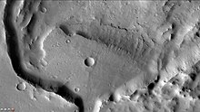
拉厄隕擊坑是一座35公里×18公里的細長撞擊坑,這是由斜向撞擊所產生的結果。一條通道將它連接到刻拉俄尼斯火山丘山頂的破火山口附近,在通道下游的末端有一片醒目的扇形沉積物。
該隕坑某些地方深約1公里深,其細長的形狀和「蝶翅」般分布的噴射物很明顯是由小角度撞擊所形成[3][4]。據信,拉厄隕擊坑中曾有過一座湖泊,該湖泊形成於附近刻拉俄尼斯火山丘熔岩熱量所融化的冰川,融化的液態水先是聚集中刻拉俄尼斯火山丘破火山口中,之後從火山口漫溢而出形成河谷和拉厄坑中的湖泊。攜帶水流的河谷寬約200米,在河谷進入隕坑的地方形成了一片三角洲[5]。
火山地熱融化冰川的事件在冰島很常見,冰川下的噴發被稱為冰湖潰洪,平均每百年兩次[6]。氣候變化研究表明,當氣候不同時,許多低緯度地區都累積了大量的積雪。[7][8]。
-
 火星勘測軌道飛行器背景相機拍攝的拉厄隕擊坑。
 -
 拉厄隕擊坑內的三角洲,註:這是前一幅圖像的放大。


另請查看[編輯]
- 火星氣候
- 火星地質
- 撞擊坑
- 小行星3537于爾根|命名
- 火星撞擊坑
參考文獻[編輯]
- ^ 1.0 1.1 "拉厄隕擊坑". Gazetteer of Planetary Nomenclature. USGS Astrogeology Research Program.
- ^ Jurgen H. Rahe, 57, Space Program Head. New York Times. 1997-06-21 [2012-09-22]. (原始內容存檔於2022-05-05).
- ^ Gault, D. J. Wedekind. 1978. Experimental studies of oblique impact. Proc. Lunar Planet. Sci. Conf. 9, 3843-3875.
- ^ Nyquist, L. 1983. Do Oblique Impacts Produce Martian Meteorites? Proc. Lunar Planet. Sci. Conf. 13, pt.2 Geophys. Res. (Supp.) 88S, A785-A798.
- ^ Fassett, C. J. Head. 2007. Valley Formation on Martian Volcanoes in the Hesperian: Evidence for Melting of Summit Snowpack, Caldera Lake Formation, Drainage and Erosion on Ceraunis Tholus, Mars. Icarus: 189, 118-135.
- ^ Bjornnson, H, F. Palsson, M. Gudmundsson. 2000. Surface and bedrock topography of the Myrdalsjokull ice cap, Iceland: The Katla caldera, eruption sites and routes of jökulhlaups. Jokull: 49, 29-46.
- ^ Head, J. et al. 2005. Tropical to mid-latitude snow and ice accumulation, flor and glaciation on Mars. Nature:434,346-351.
- ^ Head, J. et al. 2006. Extensive valley glacier deposits in the northern mid-latitudes of Mars: Evidence for Late Amazonian obliquity-driven climate change. Earth Planet. Sci. Lett. 241,663-671.