勞里湖 (阿曼)
外觀
| 勞里湖 خور روري Khawr Rawrī | |
|---|---|
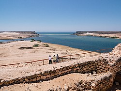
 在蘇姆胡拉姆遺址上眺望勞里湖 入海口左側為米爾巴特岬,右側為塔蓋岬 | |
| 位置 | 阿曼佐法爾省塔蓋州 |
| 座標 | 17°02′21.62″N 54°25′49.72″E / 17.0393389°N 54.4304778°E |
| 類型 | 河口灣 間歇性封閉/開放的湖泊/潟湖 |
| 河流源 | 代爾巴特乾河 |
| 海洋源 | 阿拉伯海 |
| 最大長度 | 2.5公里(1.6英里) |
| 最大寬度 | 0.4公里(0.25英里) |
| 最大深度 | 5公尺(16英尺) |
| 參考 | [1] |
| 蘇姆胡拉姆 | |
|---|---|
| سمهرم Sumhuram | |
| Samharam, Samhuram, Sumharam | |
 | |
| 類型 | 港口城堡 |
| 屬於 | 乳香之地 |
| 位置 | 阿曼佐法爾省塔蓋州 |
| 座標 | 17°2′20.4″N 54°26′4″E / 17.039000°N 54.43444°E |
| 文化 | 哈德拉毛王國、希木葉爾王國 |
| 建成時間 | 公元前3世紀 |
| 廢棄時間 | 公元5世紀 |
勞里湖(阿拉伯語:خور روري,羅馬化:Khawr Rawrī)是代爾巴特乾河的河口灣,位於阿曼佐法爾省塔蓋附近。勞里湖是間歇性封閉/開放的湖泊/潟湖,與阿拉伯海之間隔着一道沙壩,水位高時湖海之間會出現臨時的淺窄水道。[1]勞里湖是阿拉伯半島重要的鳥類繁育場所,[2] 在古代也是重要的乳香貿易海港。[1] 《愛利脫利亞海周航記》記載的摩斯卡港灣(古希臘語:Μόσχα λιμήν,意思可能是「嫩芽港灣」,或許指這裡曾經存在的紅樹林)可能就是勞里湖。[3]
勞里湖最有名的是東岸的蘇姆胡拉姆(Sumhuram)港口城堡遺址。這座古城可能就是托勒密《地理學指南》提到的深淵之城(古希臘語:Ἄβισσα πόλις)。[4][5][6]古城建立於公元前3世紀,最初屬於哈德拉毛王國的東部邊地,[7]後來又劃入希木葉爾王國的勢力範圍,[8] 最後由於沙壩封閉了勞里湖的入海口而在5世紀沒落。[1][9]2000年,古城遺址作為乳香之地四處遺蹟之一成為聯合國教科文組織世界遺產。[10]
勞里湖入海口兩側各有一座方山,西側為塔蓋岬(阿拉伯語:إنقطاعة طاقة,羅馬化:Inqiṭāʿat Ṭāqah),東側為米爾巴特岬(阿拉伯語:إنقطاعة مرباط,羅馬化:Inqiṭāʿat Mirbāṭ)。[11]這兩座方山上也有古代遺蹟。米爾巴特岬遺址又稱東哈姆爾(阿拉伯語:الحمر الشرقية,羅馬化:Al-Ḥamr al-Sharqiyah)遺址。[12]
參考資料
[編輯]- ^ 1.0 1.1 1.2 1.3 Hoorn, Carina; Cremaschi, Mauro. Late Holocene palaeoenvironmental history of Khawr Rawri and Khawr Al Balid (Dhofar, Sultanate of Oman). Palaeogeography, Palaeoclimatology, Palaeoecology. 2004-10-07, 213 (1): 1–36 [2024-01-04]. ISSN 0031-0182. doi:10.1016/j.palaeo.2004.03.014. (原始內容存檔於2012-02-04) (英語).
- ^ Dhofar beckons lovers of nature tourism. Ministry of Tourism (Oman). 29 June 2011 [26 November 2019].
- ^ Bukharin, Mikhail. The Name of Moscha Limen. Avanzini, Alessandra (編). Khor Rori Report 1. Pisa, Italy: Edizioni Plus. 2002: 323–324 [2024-01-04]. ISBN 88-8492-031-0. (原始內容存檔於2024-01-21).
- ^ Bent, James Theodore. Exploration of the Frankincense Country, Southern Arabia. The Geographical Journal. 1895, 6 (2): 109–133 [2024-01-04]. ISSN 0016-7398. JSTOR 1773739. doi:10.2307/1773739. (原始內容存檔於2024-04-14).
- ^ Bent, James Theodore. The Land of Frankincense and Myrrh. The Nineteenth Century. 1895, 38 (224): 595–613 [2024-01-04]. (原始內容存檔於2024-01-04).
- ^ Bent, James Theodore; Bent, Mabel Virginia Anna. The Identification of Abyssapolis. Southern Arabia. London, England: Smith, Elder & Co. 1900: 268–276.
- ^ Avanzini, Alessandra; Sedov, Alexander V. The stratigraphy of Sumhuram: new evidence. Proceedings of the Seminar for Arabian Studies. 2005, 35: 11–17 [2024-01-04]. ISSN 0308-8421. JSTOR 41219365. (原始內容存檔於2024-01-18).
- ^ Sedov, Alexander V. The Coins from Sumhuram: the 2001A-2004A Seasons. Avanzini, Alessandra (編). A Port in Arabia Between Rome and the Indian Ocean, 3rd C.BC-5th C.AD: Khor Rori Report 2. Rome, Italy: L'Erma di Bretschneider. 2008: 277–316. ISBN 978-88-8265-469-6.
- ^ Avanzini, Alessandra. A Port in Arabia Between Rome and the Indian Ocean, 3rd C.BC-5th C.AD: Khor Rori Report 2. Rome, Italy: L'Erma di Bretschneider. 2008 [2024-01-04]. ISBN 978-88-8265-469-6. (原始內容存檔於2024-01-04).
- ^ Land of Frankincense. UNESCO World Heritage Centre. 2000 [2021-03-25]. (原始內容存檔於2020-06-29).
- ^ Avanzini, Alessandra; Orazi, Roberto. The construction phases of Khor Rori's monumental gate. Arabian Archaeology and Epigraphy. 2001, 12 (2): 249–259 [2024-01-04]. ISSN 1600-0471. doi:10.1034/j.1600-0471.2001.d01-9.x. (原始內容存檔於2024-01-08) (英語).
- ^ Rougeulle, Axelle. A Medieval Trade Entrepôt at Khor Rori? The Study of the Islamic Ceramic from al-Ḥamr al-Sharqiya. Avanzini, Alessandra (編). A Port in Arabia Between Rome and the Indian Ocean, 3rd C.BC-5th C.AD: Khor Rori Report 2. Rome, Italy: L'Erma di Bretschneider. 2008: 645–667 [2024-01-04]. ISBN 978-88-8265-469-6. (原始內容存檔於2020-11-08).


