
克莱沃 (德国)
此条目可参照英语维基百科相应条目来扩充。 (2019年8月23日) |
| 克莱沃 Kleve | |||
|---|---|---|---|
| 城市 | |||
 天鹅城堡(Schwanenburg) | |||
| |||
克莱沃位于  | |||
 克莱沃  克莱沃 | |||
| 坐标:51°47′15″N 6°8′7″E / 51.78750°N 6.13528°E | |||
| 国家 | |||
| 联邦州 | |||
| 行政区 | 杜塞尔多夫行政区 | ||
| 政府 | |||
| • 市长 | Sonja Northing (无党派) | ||
| 面积 | |||
| • 总计 | 97.79 平方公里(37.76 平方英里) | ||
| 海拔 | 12 米(39 英尺) | ||
| 人口(2020年12月31日)[1] | |||
| • 总计 | 52,359人 | ||
| • 密度 | 535人/平方公里(1,387人/平方英里) | ||
| 时区 | CET(UTC+01:00) | ||
| • 夏时制 | CEST(UTC+02:00) | ||
| 邮政编码 | 47533 | ||
| 电话区号 | 0 28 21 | ||
| 车辆号牌 | KLE | ||
| 网站 | www.kleve.de | ||


克莱沃[2](德语:Kleve,1935年7月20日前的官方写法:Cleve[3],德语:[ˈkleːvə] (ⓘ);荷兰语:Kleef;克莱沃兰语:Kleef;英语:Cleves;法语:Clèves;拉丁语:Clivia)是德国西北部下莱茵地区(Niederrhein)的一个市镇和城市,靠近德荷边境与莱茵河。
从11世纪开始,克莱沃成为同名伯国的首府,其后来成为公国。今天,克莱沃是德国北莱茵-威斯特法伦州克莱沃县的首府。这座城市是莱茵-瓦尔应用技术大学(Hochschule Rhein-Waal)的校区所在地之一。
市镇
[编辑]The territory of Kleve comprises, next to the innercity, of fourteen villages and populated places:
Bimmen, Brienen, Donsbrüggen, Düffelward, Griethausen, Keeken, Kellen, Materborn, Reichswalde, Rindern, Salmorth, Schenkenschanz, Warbeyen and Wardhausen.
历史
[编辑]The name Kleff probably derives from Middle Dutch clef, clif ‘cliff, bluff’, referring to the promontory on which the Schwanenburg castle was constructed. Since the city's coat of arms displays three clovers (German Klee, Low German Kliev), the city's name is sometimes linked by folk etymology to the clover, but the corresponding Dutch word is klever.[4] Notably, Kleve was spelled with a C throughout its history until spelling reforms introduced in the 1930s required that the name be spelled with a K. In 2008, the CDU announced its intention to return the name to its original spelling.
The Schwanenburg Castle, where the dukes of Cleves resided, was founded on a steep hill. It is located at the northern terminus of the Kermisdahl where it joins with the Spoykanal, which was previously an important transportation link to the Rhine. The old castle has a massive tower, the Schwanenturm 180英尺(55米) high, that is associated in legend with the Knight of the Swan, immortalized in Richard Wagner's Lohengrin.
Medieval Kleve grew together from four parts — the Schwanenburg Castle, the village below the castle, the first city of Kleve on Heideberg Hill, and the Neustadt ("New City"), dating from the 14th century. In 1242 Kleve received city rights. The Duchy of Cleves, which roughly covered today's districts of Kleve, Wesel and Duisburg, was united with the Duchy of Mark in 1368, was made a duchy itself in 1417, then united with the neighboring duchies of Jülich and Berg in 1521, when John III, Duke of Cleves, married Mary, heiress of Jülich-Berg-Ravenburg.
.jpg)
Kleve's most famous native is Anne of Cleves (1515–1557), daughter of John III, Duke of Cleves and (briefly) wife of Henry VIII of England. Several local businesses are named after her, including the Anne von Kleve Galerie.

The ducal dynasty became extinct in the male line in 1609, leading to a succession crisis in the duchies. After the Thirty Years' War ended in 1648, the succession dispute was resolved with Cleves passing to the elector of Brandenburg, thus becoming an exclave of the Margraviate of Brandenburg, later Brandenburg-Prussia.
During the Thirty Years' War the city had been under the control of the Dutch Republic, which in 1647 had given Johann Moritz von Nassau-Siegen administrative control over the city. He approved a renovation of Schwanenburg Castle in the baroque style and commissioned the construction of extensive gardens that greatly influenced European landscape design. Significant amounts of his original plan for Kleve were put into effect and have been maintained to the present, a particularly well-loved example of which is the Forstgarten (Forest Garden).
.jpg)
The mineral waters of Kleve and the wooded parkland surrounding it made it a fashionable spa in the 19th century. At this time, Kleve was named "Bad Cleve" (English: Spa of Cleves).
During World War II Kleve was the site of one of the two radio wave stations that served the Knickebein aircraft navigation system. Luftwaffe bombers used radio beams from Kleve and a second station at Stolberg to navigate to British targets.[5] The Knickebein system was eventually jammed by the British. It was replaced by the higher frequency X-Gerat system, which used transmitter stations located on the channel coast of France.

Kleve was heavily bombed during the Second World War, and over 90 percent of buildings in the city were severely damaged. Most of the destruction was the result of a raid late in the war in 1945, conducted at the request of Lieutenant-General Brian Horrocks in preparation for Operation Veritable. Horrocks recounted his decision in the 1973 television documentary The World at War:
"Then they came to me and they said, “Do you want the town of Cleves taken out?” By "taken out" they meant the whole of the heavy bombers putting on to Cleves. Now, I knew that Cleves was a very fine old historical German town. Anne of Cleves, one of Henry VIII’s wives, came from there. I knew that there were a lot of civilians in Cleves, men, women and children. If I said no, they would live. If I said yes, they would die. A terrible decision you’ve got to take. But... everything depended on getting a high piece of ground at Materborn. The German reserves would have to come through Cleves, and we would have to breach the Siegfried Line and get there. And your own lives, your own troops, must come first, so I said yes, I did want it taken out. But when all those bombers went over, the night just before zero hour, to take out Cleves, I felt a murderer. And after the war I had an awful lot of nightmares, but always Cleves."[6]
Horrocks later said that this had been "the most terrible decision I had ever taken in my life" and that he felt "physically sick" when he saw the bombers overhead. [7] [8]
As a result of the bombing, relatively little of the pre-1945 city remains. Those structures spared include a number of historic villas built during the heyday of the spa Bad Kleves, located along the B9 near the Tiergarten. Of those buildings destroyed, many were reconstructed, including most of the Schwanenburg and the Stiftskirche, the Catholic parish church. Constructed on high ground, many of these landmarks can be seen from the surrounding communities.
Since 1953 there has been a broadcasting facility for FM radio and television from regional broadcaster WDR near Kleve. The current aerial mast was brought into service in 1993. The steel tube mast rises 126.4 metres high and has a diameter of 1.6 metres. It is stabilized by guy wires attached at 57 and 101.6 metres height.
After the Second World War important employers in the area were associated with the West German "Economic Miracle" (Wirtschaftswunder), and included the XOX Bisquitfabrik (XOX Biscuit Factory) GmbH and the Van den Berg'schen Margerinewerke (margarine plant), that manufactured biscuits and margarine. Another important employer was the Elefanten-Kinderschuhfabrik (Elefant Children's Shoes Factory).
在当地,零售业越来越重要,尤其是在2002年欧元制度之后。荷兰公民经常会越过开放式边境来光顾克莱沃的零售商,因此导致克莱沃的购物收入欧元大部分来自荷兰。较低的房价也吸引了一波荷兰公民在该地区置业。
人口学
[编辑]| 年份 | 人口 | ±% |
|---|---|---|
| 1815 | 6,517 | — |
| 1832 | 6,990 | +7.3% |
| 1867 | 9,209 | +31.7% |
| 1898 | 13,724 | +49.0% |
| 1910 | 18,135 | +32.1% |
| 1920 | 19,453 | +7.3% |
| 1930 | 21,561 | +10.8% |
| 1939 | 21,784 | +1.0% |
| 1950 | 28,740 | +31.9% |
| 1960 | 21,129 | −26.5% |
| 1970 | 45,675 | +116.2% |
| 1980 | 45,899 | +0.5% |
| 1990 | 47,191 | +2.8% |
| 2000 | 48,926 | +3.7% |
| 2010 | 49,794 | +1.8% |
| 2013 | 50,650 | +1.7% |
人口普查数据
[编辑]据2013年的克莱沃的统计年鉴[9],50,650人居住在该城市。人口密度约为每平方公里517.9人。86.7%的居民拥有德国公民身份(包括拥有双重国籍的居民),10.1%的人为欧盟公民身份(5.6%荷兰人和2.9%波兰人)。
2013年,该市人口分布为21岁以下年龄的人士占总人口的19.7%,21岁至40岁的人士占25.6%,41岁至60岁的人士占29.7%,61岁至80岁的人士占20.1%,81岁及更年老的人士则占4.9%。每过100名女性就有96.7名男性,每过100名21岁或以上的女性,就有93.9名男性。
81.3%的公民家庭中没有18岁以下子女,9.2%有一个孩子,6.1%有两个孩子,1.7%有三个孩子,只有0.1%人士表示自己有四个或更多的孩子。
宗教
[编辑]As the rest of the Lower Rhine region, Kleve is a predominantly Roman Catholic city.[9] The city is part of the Diocese of Münster. 61.1% of the residents are Roman Catholics, 14.4% Protestant, and 24.6% "Other". The largest section of this group are residents without any religious affiliation, but there are also sizeable Russian Orthodox and Muslim communities in Kleve.
The synagogue of Kleve was destroyed during Kristallnacht and is today commemorated on the Synagogenplatz (Synagogue square) on which the building´s outline can be seen. The fifty killed Jewish citizens of Cleves are remembered with signs that tell their names, and dates and places of death.[10]
政府
[编辑]市议会
[编辑]Prior to the Nazi Era, Kleve's local politics were dominated by the Catholic Centre Party. This situation continued with the Christian Democratic successor party CDU after the Second World War, in spite of resettled displaced people from eastern Germany, most of them Protestants. Until 2004 the CDU controlled an absolute majority of the city council.
Today, Kleve is governed by a coalition of CDU and the Green Party. Since the last local elections on 25 May 2014 the following parties are represented in Cleves' city council. In addition to nationwide parties, Offene Klever (Open Cleves) has a number of seats.
| 党派 | 百分点(%) | 议席席位 |
|---|---|---|
| 基督教民主联盟 | 39.52 | 17 |
| 社会民主党 | 28.96 | 13 |
| 联盟90/绿党 | 13.10 | 6 |
| Open Cleves | 11.00 | 5 |
| 自由民主党 | 7.42 | 3 |
| 投票率:42.32% | ||
下一次地方选举预定于2020年举行。
市长
[编辑]语言
[编辑]克莱沃和下莱茵地区的大部分地区的本土语言都是被称为克莱沃兰语(荷兰语:Kleverlands;德语:Kleverländisch)的荷兰语方言,与南海尔德兰语的关系最为密切;但该地官方语言是德语,后者在年轻一代中占主导地位。
Because of its geographical location at the Dutch-German border, there is a strong overlap in culture and language. One example of this is Govert Flinck (1615 – 1660), who though born in Kleve established himself as a Dutch artist. On the other hand, the Dutch artist Barend Cornelis Koekkoek (1803 – 1862) settled in Kleve and became a successful landscape painter. His works are collected by and exhibited in the local museum Haus Koekkoek for his and others' romantic paintings.
姊妹城市
[编辑]克莱沃的姊妹城市有:
著名人物
[编辑]- Joseph Beuys, artist, grew up in Kleve.
- Anne of Cleves, fourth wife of Henry VIII of England.
- Marie of Cleves, mother of king Louis XII of France.
- Marie Eleonore of Cleves, Duchess of consort Prussia.
- Jean-Baptiste du Val-de-Grâce, baron de Cloots, (1755-1794), politician and French revolutionary, born in Kleve.
- Barbara Hendricks, (born 1952), politician (SPD), current German Minister for the Environment, Nature Conservation, Building and Nuclear Safety, born in Kleve.
- Karl Leisner, (1915-1945), Roman Catholic martyr and beatified by Pope John Paul II, grew up in Kleve.
- Joachim Murat, (1767-1815), Grand Duke of Berg and Cleves during the Napoleonic years.
- Duke Englebert of Cleves, (1462-1506), Count of Nevers.
- Govaert Flinck, (1615-1660), Dutch painter who worked in Kleve.
- Tina Theune, (born 1953), former national coach of the German women's national football team.
- Heinrich Berghaus (1797-1884), cartographer.
- Klaus Steinbach (born 1953), swimmer and president of the Nationales Olympisches Komitee.
- Willi Lippens (born 1945), football player.
- Jürgen Möllemann (1945-2003), politician (FDP), Federal Minister.
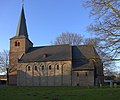
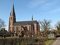
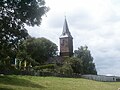
克莱沃的教堂
[编辑]-
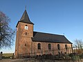 Bimmen, St. Martin
 -
 Düffelward, St. Maurice
 -
 Griethausen, St. Martin
 -
 Keeken, St. Mariae Himmelfahrt
 -
 Keeken, Reformed church
 -
 Kellen, St. Willibrord
 -
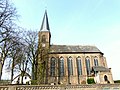
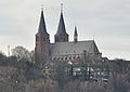 Kleve, St. Mariae Himmelfahrt
 -
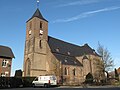
 Materborn, St. Anna
 -
 Rindern, St. Willibrord
 -
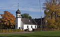
 Schenkenschanz, Reformed church


_PM2011.JPG)
参考资料
[编辑]- ^ Bevölkerung der Gemeinden Nordrhein-Westfalens am 31. Dezember 2020. Landesbetrieb Information und Technik NRW. [2021年6月] (德语).
- ^ 世界地名翻译大辞典. mall.cnki.net.
- ^ Statistik des Deutschen Reichs, Band 450: Amtliches Gemeindeverzeichnis für das Deutsche Reich, Teil I, Berlin 1939; Seite 267
- ^ L. Grootaers & G.G. Kloeke, eds., Taalatlas van Noord- en Zuid-Nederland (Leiden: E.J. Brill, 1939): [1] (页面存档备份,存于互联网档案馆).
- ^ "Most Secret War". R.V. Jones
- ^ The World at War - Episode Nineteen: "Pincers" - Thames Television 1974
- ^ Note, Kleve was bombed by a force of 295 Lancasters and 10 Mosquitoes of No. 1 and No. 8 Groups.
- ^ The Bomber Command War Diaries (页面存档备份,存于互联网档案馆): An Operational Reference Book, By Chris Everitt, Martin Middlebrook
- ^ 9.0 9.1 Statistisches Jahrbuch 2013 (PDF). Stadt Kleve. [December 22, 2015]. (原始内容存档 (PDF)于2020-09-30).
- ^ Sehenswürdigkeiten: Synagogenplatz. Stadt Kleve. [December 22, 2015]. (原始内容存档于2019-08-23).
- ^ Matthias Grass: Erdrutsch-Sieg für Sonja Northing (页面存档备份,存于互联网档案馆), Rheinische Post Kleve, September, 14th 2015
外部链接
[编辑]- 官方网站
 (德文)
(德文) - Tourist Information (页面存档备份,存于互联网档案馆) (德文)
- Edicts of Jülich, Cleves, Berg, Grand Duchy Berg, 1475-1815 (Coll. Scotti) onlineArchive.is的存档,存档日期2012-12-04
- Settlement of Dortmund between Brandenburg and Palatinate-Neuburg and the conflict of succession in Jülich, in full textArchive.is的存档,存档日期2012-12-04