
User:CHih-See Hsie/拜特吉卜林
| Bayt Jibrin بيت جبرين Beit Jibrin originally Bayt Gibril -Gabriel-[來源請求] | |
|---|---|
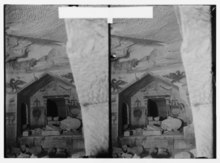
 Historic Bayt Jibrin mansion | |
| Template:Historical map series A series of historical maps of the area around Bayt Jibrin (click the buttons) | |
| Module:Location_map第527行Lua错误:找不到指定的位置图坐标,“Module:Location map/data/Mandatory Palestine”或者“Template:Location map Mandatory Palestine”都不存在 | |
| 坐标:31°36′19″N 34°53′54″E / 31.60528°N 34.89833°E | |
| Palestine grid | 140/112 |
| Geopolitical entity | Mandatory Palestine |
| Subdistrict | Hebron |
| Date of depopulation | 29 October 1948[3] |
| 面积 | |
| • 总计 | 56,185 杜纳亩s(56.2 平方公里 或 21.7 平方英里) |
| 人口(1945) | |
| • 總計 | 2,430[1][2]人 |
| Cause(s) of depopulation | Military assault by Yishuv forces |
| Current Localities | Beit Guvrin (kibbutz)[4] |
Bayt Jibrin or Beit Jibrin (阿拉伯语:بيت جبرين; 希伯來語:בֵּית גֻּבְרִין,羅馬化:Beit Guvrin), known between 200-400 CE as Eleutheropolis (Greek, Ἐλευθερόπολις, "Free City"; 阿拉伯语:إليوثيروبوليس), was a historical town, located 21公里(13英里) northwest of the city of Hebron. Depopulated in 1948, the town had a total land area of 56,185 dunams or 56.1 km2(13,900 acre), of which 0.28 km2(69 acre) were built-up while the rest remained farmland.
拜特吉卜林[a],公元200至400年间称作厄琉忒罗波利斯(希臘語:Ἐλευθερόπολις,直译:自由城,阿拉伯语:إليوثيروبوليس),为希伯伦西北21千米处一座历史古镇,1948年不再住人。该城镇总占地面积56185杜纳亩,合56.1平方千米,其中0.28平方千米为建成区,其余地带均为农地。[2][6]
During the 8th century BCE, the nearby village of Maresha was part of the Kingdom of Judah. During the days of Herod the Great, a Jewish ruler of the Herodian Kingdom, the town was the administrative center for the district of Idumea. After the turmoil of the First Jewish–Roman War and the Bar Kokhba revolt, the town became a thriving Roman colony and a major administrative centre of the Roman Empire under the name of Eleutheropolis. Eleutheropolis became one of the most important cities in the Roman province of Syria Palaestina. The city was then inhabited by Jews, Christians and pagans. Under the British Mandate of Palestine, Bayt Jibrin again served as a district centre for surrounding villages. It was captured by Jewish forces during the 1948 Arab–Israeli War, causing its Arab inhabitants to flee eastward. Today, many of the Palestinian refugees of Bayt Jibrin and their descendants live in the camps of Bayt Jibrin (ʽAzza) and Fawwar in the southern West Bank.
公元前八世纪,附近村落马雷沙[b]为犹大王国一部分。罗马治下希律王国的大希律王一朝,此地则为以土买地区的行政中心。[7]第一次犹太-罗马战争及巴尔科赫巴起义所造成的乱局平息后,该城成为繁荣的罗马殖民地,在帝国之中为重要的行政中心,时名厄琉忒罗波利斯,而发展成为罗马帝国叙利亚巴勒斯坦行省一大城市。当时该城的居民有犹太人、基督徒和其他教徒。[8]英属巴勒斯坦托管地时期,拜特吉卜林又成为周围村落的区域中心,1948年阿以战争,犹太军攻占此地,阿拉伯住民东逃。今日,出身拜特吉卜林的巴勒斯坦难民及其后代多居住于拜特吉卜林[c]及福瓦尔[d]两处难民营,均位于约旦河西岸地区南部。
The kibbutz of Beit Guvrin was established to the north of Bayt Jibrin, on the villages' lands, in 1949. The archaeological sites of Maresha and Beit Guvrin, including their ancient burial caves, are today an Israeli national park known as Beit Guvrin National Park. It is also a UNESCO World Heritage Site. Eleutheropolis remains a titular see in the Roman Catholic Church.
贝特古夫林基布兹于1949年建于拜特吉卜林村内北部土地上。当地马雷沙、贝特古夫林两处考古遗址及其古代墓穴今列作以色列国家公园,名为贝特哥夫林国家公园;2014年,当地列入世界遗产名录。[9]厄琉忒罗波利斯在罗马天主教会仍留有虚衔教座。[10]
Name[编辑]
.jpg)
The town was renamed over the centuries. Its Aramaic name Beth Gabra, preserved by the geographer Ptolemy in the Greek variation of Βαιτογάβρα (Baitogabra), translates as the "house of the [strong] man" or "house of the mighty one". The antecedent might be seen in the name of an Edomite king: Ḳaus-gabri or Kauš-Gabr, found on an inscription of Tiglathpileser III.
千百年来,该镇数易其名。此地在阿拉米语中名为「贝特加卜拉」(Beth Gabra),存于地理学家托勒密著作中,以希腊文转写为「Βαιτογάβρα」,意为「(健)夫之家」。[11]此名的前身或可见于以东某代国王名中,其名卡乌斯-加卜里(Ḳaus-gabri),又作卡乌什-加卜尔(Kauš-Gabr),镌刻于提革拉毘列色三世一处铭文上。[12]
Ptolemy referred to it as Baitogabra.According to historical geographer A. Schlatter, the name Betaris mentioned by Josephus should either be identified with Bittir, or else the T amended to Gamma so as to read Begabrin.
托勒密称此地为拜托伽布拉,[13]而根据神学家、历史地理学家阿道夫·施拉特尔说法,约瑟夫斯笔下「柏塔里斯」(Βηταριν,拉丁語:Betaris)之名,其所指或当定在伯利恒以西的巴地尔,或将其中的「τ」修正为「γ」,从而读作「柏伽布林」(Βηγαβριν)。[註 2][14][15]
In the year 200 CE, Roman Emperor Septimius Severus gave it the status of a city under a new Greek name, Eleutheropolis (Ἐλευθερόπολις), meaning 'City of the Free', and its inhabitants were given the rank of Roman citizens under the laws of ius italicum." In the Peutinger Tables in 393 CE, Bayt Jibrin was called Beitogabri. In the Talmud, compiled between the 3rd and 4th centuries, it was known as Beit Gubrin (or Guvrin). To the Crusaders, it was known as Bethgibelin or Gibelin. Another name in medieval times may have been Beit Jibril, meaning "house of Gabriel". In Arabic, Bayt Jibrin or Jubrin (بيت جبرين) means "house of the powerful", reflecting its original Aramaic name, and the town was probably called Bayt Jibrin or Beit Jibril throughout its rule by various Muslim dynasties.
公元200年,罗马皇帝塞普蒂米乌斯·塞维鲁赋予此地以城市地位,用希腊语定新名厄琉忒罗波利斯,其意为「自由之城」,城中住户根据授予意大利权[註 3]的有关法律皆得到罗马公民地位。[16][17][18][15] 在393年的波伊廷格地图中,此地记作「柏托伽布里」(Betogabri),而在三四世纪结集而成的塔木德中,则称「贝特古卜林」。[註 4][11]十字军将其称为「贝特吉贝林」或「吉贝林」,[19][20]而中世纪时期此地可能还有「贝特吉卜利勒」之称,意为「吉卜利勒之屋」。[20]在阿拉伯语中,此地之名称「拜特吉卜林」或「朱卜林」[e],意为「强力者之屋」,[21]仍反映出其最初的阿拉米语名称,[11]而在众多穆斯林王朝统治下,此地大概即称作拜特吉卜林或贝特吉卜利勒。
History[编辑]
铁器时代的马雷沙[编辑]
The excavations have revealed no remains older than the Iron Age, a time when the Judahite town of Maresha rose on the tell to the south of Bay Jibrin known in Arabic as Tell Sandahanna and in Hebrew as Tel Maresha. This corresponds to several Hebrew Bible mentions of Maresha. However, local folklore tells that the former Arab village of Bayt Jibrin was first inhabited by Canaanites. After the destruction of the Kingdom of Judah in 586 BCE, the city of Maresha became part of the Edomite kingdom. In the late Persian period a Sidonian community settled in Maresha, and the city is mentioned three times in the Zenon Papyri (259 BCE).
考古发掘的结果,当地遗迹均不早于铁器时代,当时犹大王国的城镇马雷沙坐落于拜特吉卜林以南一座土墩上,今在阿拉伯语中称为桑代汉奈土丘[f],在希伯来语则称为马雷沙土丘[g]。[22]此地与希伯来圣经中几处提及马雷沙的内容相呼应。然而,当地则传说旧阿拉伯村庄拜特吉卜林最初是由迦南人定居。[23][24]
犹大王国于公元前586年灭亡后,马雷沙成为以东王国一部分。而波斯帝国统治时代晚期,城中又有西顿人社群落足。在埃及官员芝诺的纸草书(前259年)中,凡三次提及该城。[25]在马加比起义中,马雷沙为阻挡犹太人进攻的堡垒,遭到马加比家族报复。前112年,马雷沙为哈斯蒙尼国王海卡努斯一世所克,城市被毁,此后以土买地区由哈斯蒙尼王朝控制,以东人则被迫改信犹太教。数十年后,庞培攻克哈斯蒙尼王国,于前67年将马雷沙一带划给其他宗教信徒;前40年,末代哈斯蒙尼国王安提柯二世联合安息帝国将此「强健之城」夷为平地,以后再未重建。从此,附近的贝特古夫林接替马雷沙,成为地区主要的中心城镇。[26]
Roman and Byzantine periods[编辑]
In the Jewish War (68 CE), Vespasian slaughtered or enslaved the inhabitants of Betaris. According to Josephus: "When he had seized upon two villages, which were in the very midst of Idumea, Betaris (原文如此) (corrected to read Begabris), and Caphartobas, he slew above ten thousand of the people, and carried into captivity above a thousand, and drove away the rest of the multitude, and placed no small part of his own forces in them, who overran and laid waste the whole mountainous country." However, it continued to be a Jewish-inhabited city until the Bar Kokhba revolt (132-135 CE).
第一次犹太–罗马战争期间(公元68年),韦斯巴芗将「柏塔里斯」城中住民加以奴戮。按照约瑟夫斯的说法,「当他夺取两座村庄,皆位于以土买正中心位置,即柏塔里斯(原文如此)[註 5]及卡法耳托巴斯时,他屠戮了一万以上人口,将超过千人监禁下来,将众人中其余的部分驱离,将自己军力中不少人安插其中,侵掠整座山国,使其沦为丘墟」。[28]然而,此后当地仍是犹太人居住的城市,直到巴尔科赫巴起义(132至135年)为止。[29]

Septimius Severus, Roman Emperor from 193 to 211, granted the city municipal status, under a new Greek name, Eleutheropolis, meaning "City of the Free", and giving its citizens the ius italicum and exempting them from taxes. Coins minted by him, bearing the date 1 January 200, commemorate its founding and the title of polis. 公元193至211年间在位的罗马皇帝塞普蒂米乌斯·塞维鲁授予该城自治权,[30]启用希腊语新名「厄琉忒罗波利斯」,意为「自由之城」,又给予其中市民意大利权,免于赋税。[31][17][32]此人铸有一批硬币,其上铭刻日期为200年1月1日,即为纪念此地建城及冠名「城邦」(πολις)之事。[33] Eleutheropolis, which covered an area of 65公頃(160英畝) (larger at the time than Aelia Capitolina - the Roman city built over the ruins of Jewish Jerusalem), flourished under the Romans, who built public buildings, military installations, aqueducts and a large amphitheater. Towards the end of the 2nd century CE, Rabbi Judah the Prince ameliorated the condition of its Jewish citizens by releasing the city from the obligations of tithing home-grown produce, and from observing the Seventh Year laws with respect to the same produce, as believing this area of the country was not originally settled by Jews returning from the Babylonian captivity. 厄琉忒罗波利斯占地65公頃(160英畝),大于爱利亚加比多连[註 6],在罗马治下繁荣一时,罗马人在此建设公共建筑、军事设施、引水通道,又建有一座大规模的圆形竞技场。直到二世纪末,对该城出产之物,拉比犹大王子免除其上交什一奉献的义务,同时也允许其不必遵奉安息年的规矩,从而改善了城中犹太市民的生存处境,犹大王子如此做,是因为认为国土这一带区域起初并非自巴比伦之囚中归还的犹太人所居住。[34] The vita[需要解释] of Epiphanius of Salamis, born into a Christian family near Eleutheropolis, describes the general surroundings in Late Antique Judaea. The second chapter of the vita describes the details of the important market of Eleutheropolis. 萨拉米斯的爱比法生在厄琉忒罗波利斯附近一个基督徒家庭,其传记对古典时代晚期的犹地亚地区环境有所描述。[35]传记第二章即详细写到厄琉忒罗波利斯地位重要的集市。[36] Seven routes met at Eleutheropolis,有七条道路交汇此地,[30] and Eusebius, in his Onomasticon, uses the Roman milestones indicating the city as a central point from which the distances of other towns were measured. The Madaba Map (dated 542-570 CE) shows Eleutheropolis as a walled city with three towers, a curving street with a colonnade in the central part and an important basilica. In the centre is a building with a yellowish-white dome on four columns. 凯撒利亚的优西比乌也在其《圣地志》[註 7]中以此地为中心点,度量其他城镇的里程。[16]马达巴地图(年代推测为542至570年)中将厄琉忒罗波利斯表现作带有三座塔楼、环绕城墙的城市,其中心区域有一条曲折街道,柱廊覆盖其上,又有一座高级的巴西利卡。城中央为一座建筑,其穹顶颜色黄白,踞于四柱之上。[37] Eleutheropolis was last mentioned in the ancient sources by the near contemporary itinerarium of the Piacenza Pilgrim, about 570. 在古典时代文献中,厄琉忒罗波利斯最后一次提及是在时代相近、由皮亚琴察朝圣者所作的行程录[註 8]中,[38]年份大概在570年。
In the 1st and 2nd centuries CE, Christianity penetrated the city due to its location on the route between Jerusalem and Gaza. The city's first bishop, Justus, was one of the 70 Disciples. Eleutheropolis was a "City of Excellence" in the fourth century and a Christian bishopric with the largest territory in Palaestina. In 325 CE, Eleutheropolis was the seat of Bishop Macrinus, who in that year attended the First Council of Nicaea. Epiphanius of Salamis, Bishop of Salamis in Cyprus, was born at Eleutheropolis; at Ad nearby he established a monastery which is often mentioned in the polemics of Jerome with Rufinus and John, Bishop of Jerusalem. Epiphanius also mentions that Akouas, a disciple of Mani, had been the first to spread Manichaeism in Eleutheropolis and the rest of Palestine during the reign of Aurelian (270-275 AD).
公元一、二世纪,由于该城正坐落于耶路撒冷到加沙城的要道之上,基督教也渐渐传入城中。城中第一名主教犹士都[註 9]为七十门徒之一。厄琉忒罗波利斯在四世纪时称为「卓越之城」,[30]在巴勒斯坦地区领有面积广大的教区。公元325年,厄琉忒罗波利斯为主教马克里努斯(Macrinus)的教座所在,此人当年与会第一次尼西亚公会议。[33]又有塞浦路斯城市萨拉米斯的主教爱比法生于该城,在附近的阿德(Ad)建有修道院,而在哲罗姆与鲁菲努斯、耶路撒冷主教约翰等人的争辩中多次提及。[33]爱比法同时提到,摩尼的门徒阿库亚斯为在厄琉忒罗波利斯及巴勒斯坦其余地区传播摩尼教的第一人,时为奥勒良一朝(270至275年)。[39]
Beit Guvrin is mentioned in the Talmud in the 3rd and 4th centuries, indicating a revival of the Jewish community around that time. The tanna Judah b. Jacob and the amora Jonathan (referred to in the Talmud as "Yonatan me-Bet Guvrin" or Jonathan of Bet Guvrin) were residents of the city. The Talmudic region known as Darom was within the area of Eleutheropolis ("Beit Guvrin"), 三四世纪的塔木德中也提到贝特古夫林,说明这段时间前后有犹太社区在此复兴。[29]坦拿[註 10]犹大·本·雅各[h]与阿莫拉[註 11]约拿单(此人在塔木德中称作约拿单·梅贝特古夫林,[i]或称贝特古夫林的约拿单)二人皆为城中居民。塔木德中称为达罗姆[j]的地区,也在厄琉忒罗波利斯(即贝特古夫林)范围内,[40] later known by its Arabic corruption ad-Dārūm.这一地区其后以其阿拉伯语讹称「达鲁姆」[k]为人所知。[41] Excavations at Eleutheropolis show a prosperous city, and confirm the presence of Jews and Christians in the area. It was described as one of Palestine's five "Cities of Excellence" by 4th-century Roman historian Ammianus Marcellinus. During the Roman-Byzantine era, water was brought into Beit Gubrin (Bayt Jibrin) via an aqueduct that passed through Wādi el-ʻUnqur, a watercourse that originates from a natural spring to the south-west of Hebron, and running in a north-westerly direction, bypassing Idhna on the north, for a total distance of about 25公里(16英里). Remnants of the aqueduct are still extant. 在厄琉忒罗波利斯进行的考古发掘显示当地曾民康物阜,确证犹太人与基督徒都曾在这一带居住。在四世纪罗马历史学家阿米阿努斯·马尔切利努斯笔下,此地与巴勒斯坦另外四座城市一道描述为「卓越之城」。[30]在罗马帝国及拜占庭统治的时期,有引水通道穿过艾勒温库尔溪[l],将水引入城中。艾勒温库尔溪源于希伯伦西南一处天然泉水,流向西北,经过以北城镇伊兹纳[m],全长约25公里(16英里)。[42]引水通道的遗迹至今尚存。 The territory under the administration of Eleutheropolis encompassed most of Idumea, with the districts of Bethletepha, western Edom and Hebron up to Ein Gedi, and included over 100 villages. 厄琉忒罗波利斯所辖地方囊括以土买大多数地区,包括柏特勒忒法(Bethletepha,今拜特纳提夫)、以东地西部地区、希伯伦,直至恩戈地,超过一百座村庄在其辖境。[40]
Bayt Jibrin is mentioned in the Talmud (redacted 5th–6th century CE) under the name Beit Gubrin. In the Peutinger Tables (393 CE), the place is called Beto Gabra, and shown as 16 Roman miles from Ascalon.[43] The true distance is 20 English miles.
在公元393年的波伊廷格地图中,此地称作「柏托伽布拉」(Beto Gabra),距阿斯卡隆(Ascalon,今阿什凯隆)十六罗马里,[註 12]而实际上,这一距离是二十英里。[43]
The Midrash Rabba (Genesis Rabba, section 67) mentions Beit Gubrin in relation to Esau and his descendants (Idumaeans) who settled the region, and which region was renowned for its fertile ground and productivity.
米德拉什拉巴[註 13](创世记拉巴,第67节)提到贝特古夫林,将此地同以扫及其居住此地的子孙(以土买人)相联系,也提到这片地区以其肥沃土壤和丰富出产而闻名。[44]
Early Islamic period[编辑]

The 9th-century historian al-Baladhuri mentions Bayt Jibrin (the name given to it by the Arabs following the Muslim conquest) as one of ten towns in Jund Filastin (military district of Palestine) conquered by the Muslims under Amr ibn al-As during the mid-630s' Muslim conquest. Amr enclosed a domain to Bayt Jibrin, which he named Ajlan, after one of his freemen. 九世纪史学家拜拉祖里有提及拜特吉卜林(此名是穆斯林征服叙利亚后阿拉伯人对当地的称呼),称为巴勒斯坦军区[註 14]十座城镇之一,这片地区是穆斯林在阿姆鲁·本·阿斯领导下、在公元630年代所作征服中攻克。阿姆鲁在拜特吉卜林圈占一片领地,称为埃杰兰[n],是为其手下一名自由人的名字。[45] The 1904 Analecta Bollandiana recounts that in 638 the Muslim army beheaded fifty soldiers in Bayt Jibrin from the Byzantine garrison of Gaza who refused to abandon Christianity and who were then buried in a church built in their honor. 《博兰德短论选集》(Analecta Bollandiana)1904年刊叙述道,638年穆斯林军队在拜特吉卜林将五十名士兵斩首,这些人皆出自东罗马帝国在加沙的守备部队,拒绝离弃基督信仰,他们之后葬在一座为纪念他们而建的教堂中。[33] In the beginning of the power struggle between Ali and Mu'awiya for the position of caliph, Amr left Medina in the Hejaz and took up residence at his estate called Ajlan in Bayt Jibrin with his sons Muhammad and Abdallah. The latter died there. The Umayyad prince and governor of Palestine, Sulayman ibn Abd al-Malik, received the news of his becoming caliph in 715 during his stay in Bayt Jibrin. 在阿里同穆阿维叶为争夺哈里发大位而爆发权力斗争之初,阿姆鲁离开汉志的麦地那,在他位于拜特吉卜林、名为埃杰兰的地产落脚居住,与他同住的还有两子穆罕默德及阿卜杜拉,后者卒于当地。倭马亚王朝的王子兼巴勒斯坦总督苏莱曼·宾·阿卜杜勒-麦立克在715年闻讯得知自己成为哈里发,当时他正驻在拜特吉卜林。[46]
In 750 Palestine came under Abbasid rule. Bayt Jibrin may have already been devastated in 788,[47] but in any event, in 796, it was destroyed by Bedouin tribesmen in an effort to combat Christian influence in the region during a civil war between the Arab tribal federations of the area. According to a monk named Stephen, "it was laid waste, and its inhabitants carried off into captivity".[48] However, by 985, Bayt Jibrin seemed to have recovered, judging by the writings of the Jerusalemite geographer al-Muqaddasi:
公元750年,巴勒斯坦纳入阿拔斯王朝统治。拜特吉卜林在788年或已毁坏,但总之此地之彻底平毁是在796年,当时此地一带几个阿拉伯部落联盟正在内战,贝督因部落民为对抗基督教对地区的影响而作出此事。根据名为司提反的僧侣记载,「它被毁成废墟,住户则掳走监禁」。然而,到985年,拜特吉卜林似乎已经恢复元气,耶路撒冷的地理学家穆卡达西评判道:
| “ | (拜特吉卜林)这座城市一边在山地,一边在平原。它的领土有达鲁姆(古代称达罗马,现在称代兰)的称呼,上面有大理石采石场。这片区域的出产运送到首府(拉姆拉)。这城是周边地土商旅的辐辏,地方富有又繁荣,领着许多好地。它的人口,现在却在减少……[49][50] | ” |
"[Bayt Jibrin] is a city partly in the hill country, partly in the plain. Its territory has the name of Ad Darum (the ancient Daroma and the modern Dairan), and there are here marble quarries. The district sends its produce to the capital (Ar Ramlah). It is an emporium for the neighbouring country, and a land of riches and plenty, possessing fine domains. The population, however, is now on the decrease...."
Today, there is no marble quarry anywhere in Palestine, but al-Muqaddasi probably referred to the underground chalkstone quarries known today as "bell caves".[來源請求]
穆卡达西提到当地出产「大理石」,另外波斯旅行家纳西尔·库斯老1035年游历此地一带,在其《游记》[o]中也记载到有相当软的「大理石」。但综合现代文史考古成果,二人笔下的「大理石」所指大概是白垩;穆卡达西之「大理石采石场」,所指当是今日称为「钟形洞窟」的洞穴。[51]
伊斯兰时期尚有一些传说同拜特吉卜林相关。例如至晚在公元九世纪末,有称拜特吉卜林为四座「乐园之城」其一,据传此种说法出自改信伊斯兰教的犹太人卡卜·阿勒阿赫巴尔;又据十三世纪史学家雅古特·哈迈维引述,拜特吉卜林所在山谷即为《古兰经》蚂蚁章中素莱曼经过的「蚁谷」。[52]
Crusader and Mamluk eras[编辑]

In 1099, Crusaders invaded Palestine and established the Kingdom of Jerusalem. In 1135, King Fulk of Jerusalem erected a castle on the lands of Bayt Jibrin, the first of a series of Crusader fortifications built at this time to ensure control over the ports of Caesarea and Jaffa.In 1136, King Fulk donated the castle to the Knights Hospitallers. In 1168, the Hospitallers were granted a charter to establish a Frankish colony, which they named "Bethgibelin". 公元1099年,十字军攻入巴勒斯坦,建立耶路撒冷王国。1135年,耶路撒冷王富尔克在拜特吉卜林土地上兴建一座堡垒,是为十字军当时所建一连串要塞中的第一座,其目的乃为确保对凯撒利亚、雅法诸港口的控制。[19][23] 翌年富尔克将堡垒捐赠于医院骑士团。1168年,医院骑士团得到特许建立法兰克人的殖民地,命名为「贝特吉贝林」(Bethgibelin)。[53] Christian settlers in Beit Jibrin were promised a share of property looted from the Muslims. It was on the itinerary of Benjamin of Tudela, who found three Jews living there when he visited the country. 居于拜特吉卜林的基督徒受诺可以分得从穆斯林处缴获的战利品。[54]当时基督徒认定此地即古代的别是巴,当地又载于图德拉的本雅明所作行程录中,此人游历附近一带时,发现当地居住有三名犹太人。[55] The Ayyubid army under Saladin sacked Bethgibelin in 1187, after most of the Kingdom of Jerusalem came under Muslim control as a consequence of his victory at the Battle of Hittin. Soon after its capture Saladin ordered the demolition of the Crusader castle. From 1191 to 1192, the town was held in probate by Henry of Champagne, as lord of the Kingdom of Jerusalem, while Saladin and Richard the Lionheart negotiated a ceasefire. 萨拉丁麾下的阿尤布军队于1187年洗劫贝特吉贝林,此前萨拉丁在哈丁战役中得胜,耶路撒冷王国大部分从而已在穆斯林之手。夺占堡垒之后,萨拉丁不久即下令将其拆毁。[56]自1191年至1192年,香槟的亨利二世根据遗嘱领有此城,此人为耶路撒冷王国之主,[註 15]而当时萨拉丁同狮心王理查正商议休战。[57]
However, the Crusaders remained in control of Bethgibelin until 1244, when the Ayyubids reconquered it under Sultan as-Salih Ayyub. By 1283, the Mamluks had taken control and it was listed as a domain of Sultan Qalawun. 1192年,法兰克人复得贝特吉贝林,此后堡垒归之五十余年,直到1244年阿尤布军在萨利赫·阿尤布带领下再次攻克此地。1283年时,马穆鲁克统治此地,列为苏丹嘉拉温的领地。[58] The city prospered under the Egypt-based Mamluk Sultanate and served as a postal station. During Mamluk rule, Bayt Jibrin administratively belonged to Hebron and was under the jurisdiction of the Shafi'i (a school of law in Sunni Islam) qadi (head judge) of that city. 在以埃及为中心的马穆鲁克苏丹国统治下,城市繁荣一时,作为邮驿使用。[23]马穆鲁克时期,拜特吉卜林行政上受希伯伦管辖,由其城中沙斐仪派卡迪负责裁判司法。[59]
Ottoman rule and the 'Azza family[编辑]

Bayt Jibrin and all of Palestine was conquered by the Ottomans after their victory over the Mamluks during the 1516 Battle of Marj Dabiq. Bayt Jibrin subsequently became part of the nahiya (subdistrict) of Hebron (al-Khalīl), which was part of the sanjak ("district") of Gaza. The Ottomans did not exercise strict control over their territories and tended to keep local leaders in their traditional positions as long as they complied with the higher authorities and paid imperial taxes. During Suleiman the Magnificent's reign, in 1552, the destroyed Crusader castle in Bayt Jibrin was partially rebuilt in order to protect the main road between Gaza and Jerusalem.[59] In 1596, the inhabitants of Bayt Jibrin, consisting of 50 Muslim families, paid taxes on wheat, barley and sesame seeds, as well as goats and beehives.
拜特吉卜林乃至巴勒斯坦全地之为奥斯曼帝国所克,是在奥斯曼于1516年达比克草原战役战胜马穆鲁克以后。拜特吉卜林随后成为哈利勒纳希耶的一部分,[註 16]而又从属于加沙桑贾克。奥斯曼人在领土上并未实行严密的统治,而倾向允许当地首领因袭地位,只需顺从上级辖制,向帝国缴纳赋税即可。[23]在苏莱曼大帝统治下,1552年,拜特吉卜林已毁的十字军堡垒部分得到重建,以保护加沙与耶路撒冷之间干道安全。1596年,有记载拜特吉卜林的住户共五十家,皆为穆斯林,而缴纳小麦、大麦、芝麻为赋税,也缴纳山羊同蜂巢。[60]
In the 19th century, Bayt Jibrin was the seat of the 'Azza family, who had ruled the area since migrating to Palestine from Egypt. In the 1840s, after the Ottomans attempted to crush local leaders in the Hebron Hills for their refusal to pay taxes, the 'Azza family joined a revolt against Ottoman rule. They had aligned themselves to the 'Amr clan of the Hebron-area village of Dura. Between 1840 and 1846, hostilities were raging between the Qays and Yaman tribo-political factions in southern Palestine. The 'Azza and 'Amr families, part of the Qays confederation, were constantly clashing with the Yaman-aligned Abu Ghosh clan, who were based in the vicinity of Jerusalem. In 1846, the shaykh (chief) of Bayt Jibrin, Muslih al-'Azza (known as the "giant of Bayt Jibrin"), the leader of the 'Amr clan, and other local leaders were exiled, but were allowed to return in the early 1850s.
十九世纪,拜特吉卜林为埃泽[p]家族的宝座村,[註 17]这一家族自从埃及迁徙至巴勒斯坦以来,一直管治当地。[61]1840年代,奥斯曼意图镇压希伯伦山的当地首领,以惩罚其拒绝缴税之行为,此事后埃泽家族亦加入反抗奥斯曼统治的叛乱,同希伯伦地区杜拉村的阿姆鲁家族联合。1840至1846年间,巴勒斯坦南部卡伊斯[q]、亚曼[r]两部落联盟间战火炽盛,埃泽、阿姆鲁两家皆在卡伊斯部落联盟,同亚曼一派、驻在耶路撒冷附近的阿布哥什家族[s]争战不休。[62]1846年,拜特吉卜林谢赫穆斯利赫·阿勒埃泽[t]、阿姆鲁家族首领乃至当地其他首领皆遭流放,但在1850年代初又获准回归。[63]

In 1855, the newly appointed Ottoman pasha ("governor") of the sanjak ("district") of Jerusalem, Kamil Pasha, attempted to subdue the rebellion in the Hebron region. Kamil Pasha marched towards Hebron with his army in July 1855, and after crushing the opposition, he ordered the local shaykhs to summon to his camp. 1855年,耶路撒冷桑贾克新到任的奥斯曼帕夏卡米勒帕夏尝试平复希伯伦地区的叛乱,遂率军于1855年7月向希伯伦进发。遇到抵抗后,他命令当地谢赫到其营中集合。[64] Several of the shaykhs, including the leader of the 'Amr clan and Muslih al-'Azza, did not obey the summons. Kamil Pasha then requested that the British consul in Jerusalem, James Finn, serve as an envoy and arrange a meeting with Muslih. Finn sent his vice-consul to assure Muslih of his safety in Hebron and convinced him to meet with Kamil Pasha. Muslih was well received in Hebron and returned to Bayt Jibrin escorted by twenty of the governor's men. Soon after, the Kamil Pasha paid a visit to Bayt Jibrin to settle affairs and collect the town's overdue taxes. 某些谢赫如阿姆鲁家族首领及穆斯利赫·阿勒埃泽等人抗命不来,卡米勒帕夏于是请求耶路撒冷的英方领事詹姆斯·芬恩作为使节同穆斯利赫组织会见。芬恩派遣副领事向穆斯利赫保证其在希伯伦安全无虞,说服其与卡米勒帕夏会面。穆斯利赫在希伯伦得到礼遇,在帕夏手底二十人护送下回到拜特吉卜林。卡米勒帕夏旋即访问拜特吉卜林,从而调解事态、收缴镇上未付的税收。[64][65] Kamil Pasha took an oath of loyalty from all the local shaykhs in the Hebron region, including those under the rule of Muslih al-'Azza. 卡米勒帕夏要求希伯伦当地所有谢赫宣誓效忠,受穆斯利赫·阿勒埃泽管治者亦不例外。[64]
In 1838, American archeologist Edward Robinson identified Bayt Jibrin as the site of both ancient Eleutheropolis and ancient Bethgebrim. He cited William of Tyre's reference to the Arabic name. Later travelers who visited Bayt Jibrin during that time were very impressed both by the shaykh of Bayt Jibrin, as well as by his "castle" or "manor". At the time, the remains of the Crusader fortress still served for defensive purposes in the village. According to Bayt Jibrin's shaykh, in 1863, he was in command of 16 villages in the area and pledged "to provide as many as 2,000 men to the government if necessary." In 1864, however, Muslih's brother told a traveler that Muslih and his property had been seized on "false charges of treason," and that he had been banished to Cyprus and then beheaded.
1838年,美国考古学者爱德华·罗宾逊认定拜特吉卜林正是古代厄琉忒罗波利斯和柏特革布林(Bethgebrim)二者遗址所在,并引用提尔的威廉笔下文字作为其阿拉伯名称的参考。[66]此后这一时期拜访拜特吉卜林的游人皆对当地谢赫和其「堡垒」「宅第」印象深刻。当时十字军要塞的废墟在村中仍起到防卫职能。[67]按拜特吉卜林谢赫的说法,1863年他统管当地十六座村落,并要承诺「如有必需,就向官府提供二千人之多的男丁」。[68]然而1864年,穆斯利赫之弟向游人透露,出于「叛国的虚假指控」,穆斯利赫人遭逮捕、家产抄没,他本人被放逐到塞浦路斯,随即在当地处斩。[69]
Socin found from an official Ottoman village list from about 1870 that Bayt Jibrin had a population of 508, with a total of 147 houses, though the population count included men, only.
Bayt Jibrin's status began to decline throughout the 19th century. According to Western travelers it was "a small and insignificant village". The primary factors that contributed to the decline were the Bedouin raids on Bayt Jibrin's countryside villages, the 'Azza revolt, tribal warfare among the inhabitants of the towns and villages throughout Palestine and epidemics which struck the town and the nearby area.
十九世纪以来,拜特吉卜林地位渐渐衰落。根据西方游人的说法,其为「又小又不起眼的村庄」。至于衰落,推动此事主要的因素在于贝督因对周遭乡里的突袭、埃泽的叛乱、遍及巴勒斯坦全地城乡住民的部落战事、在镇中及附近地区肆虐的瘟疫。[62]东方学家阿尔伯特·佐钦从1870年前后一份官方出具的奥斯曼村落名录中发现,拜特吉卜林有人口508人,房屋计147座,不过人口一项数据仅统计男性。[70][71]1896年,估计当地人口则有1278人。[72]
In 1896 the population of Bet dschibrin was estimated to be about 1,278 persons.
British Mandate era[编辑]
After the British Army captured Palestine from the Ottomans in 1917–1918,[73] 英国陆军1917至1918年自奥斯曼夺取巴勒斯坦后, Bayt Jibrin resumed its role as an important town in the District of Hebron. The population was entirely Muslim, and had two schools, a medical clinic, a bus and a police station. The town's inhabitants cultivated grain and fruit, and residents from nearby towns flocked to its weekly market or souk. During the winter of 1920-1921 there was a severe outbreak of malaria. 157 villagers (one-sixth of the population) died with the mortality rate in the district reaching 68 per 1,000. Crops remained unharvested due to lack of people strong enough to work in the fields. The British authorities began a program of sealing open wells, improving drainage and distributing quinine across Palestine. 拜特吉卜林作为希伯伦区重镇恢复了往日地位。城中人口全为穆斯林,有两座学校,一间诊所,一辆公交车及一处警局。住户种植谷物、水果,周围城镇的居民则云集城中一周一度的集市(苏克)。[21]1920、1921年间冬季,当地爆发严重的疟疾。村民中157人(占人口六分之一)死亡,区内死亡率攀升至千分之六十八。由于体力足以田作的人手不足,庄稼亦无从收获。英方当局启动工程防疫,封闭露天水井、改善排水、在巴勒斯坦全境分发奎宁。[74][75] In the 1922 census of Palestine conducted by the British Mandate authorities, Bayt Jibrin had a population of 1,420, all Muslim, increasing the 1931 census to 1,804, still all Muslim, in a total of 369 houses. 1922年巴勒斯坦人口普查由英属托管地当局组织,结果拜特吉卜林有人口1420人,全为穆斯林。[76]1931年人口普查中,人口升至1804人,仍然全为穆斯林,居于369座房屋中。[77]
On 10 January 1938, during the Palestinian Arab revolt of 1936-1939, J. L. Starkey, a well-known British archaeologist, was killed by a group of armed Arabs on the track leading from Bayt Jibrin to Hebron.
1938年1月10日,在巴勒斯坦阿拉伯人的起义中,知名的英国考古学者J·L·斯塔基在自拜特吉卜林到希伯伦的途中为一群武装阿拉伯人所害。[78]
In the 1945 statistics Bayt Jibrin had 2,430 Muslim inhabitants, with a total of 56,185 dunams of land. Of this, 2,477 dunums were irrigated or used for plantations, 31,616 dunams used for cereals, 在1945年巴勒斯坦村长统计中,拜特吉卜林有穆斯林住户2430人,[1]土地总面积56185杜纳亩。[2]全部土地中2477杜纳亩有灌溉或开辟有种植园,31616杜纳亩则用于种植谷物,[79] while 287 dunams were built-up (urban) areas. 又有287杜纳亩为建成区。[6]
Bayt Jibrin was in the territory allotted to the Arab state under the 1947 UN Partition Plan.
在1947年联合国分治方案中,拜特吉卜林位于划分给阿拉伯国的土地上。[80]
1948 war[编辑]

The First Battalion of the Egyptian Army were ordered to take up position in Bayt Jibrin during the second half of May during the 1948 Arab-Israeli War. At the same time, The New York Times correspondent reported that thousands of Jaffa's inhabitants had fled inland, including "large numbers" to the Bayt Jibrin area. In October 1948, the Israeli Army (IDF) launched Operation Yoav, which differed from operations three months earlier, as the IDF was now equipped with aircraft, artillery, and tanks. On October 15–16, the IDF launched bombing and strafing attacks on a number of towns and villages, including Bayt Jibrin. According to Morris, the towns caught in the fighting were neither psychologically nor defensively prepared for aerial strikes, and Israeli Air Force bombing of Bayt Jibrin on October 19 set off a "panic flight" of residents from the town.
1948年阿以战争爆发,当年5月下半月,埃及陆军第一营受命攻占拜特吉卜林。同时,纽约时报的通讯记者报道称上千名雅法住户逃入内陆,其中「数量庞大」的一部分涌入拜特吉卜林一带。[81]10月,以色列陆军发动约押行动,以军当时已装备有飞机、火炮、坦克,故此时作战大不同于三个月前。15至16日,以军对许多村镇展开轰炸扫射,拜特吉卜林亦在其列。[82]根据历史学家本尼·莫里斯所述,卷入战争的城镇对空袭既无心理准备,更未有所防御,以色列空军10月19日对拜特吉卜林的轰炸引发镇上居民「恐慌逃亡」。[83]
On October 23, a United Nations-imposed ceasefire went into effect, however, there was an IDF raid on the neighboring police fort on the night of October 24, which resulted in more villagers fleeing Bayt Jibrin. Israeli troops from the Giv'ati Brigade then occupied Bayt Jibrin and its police fort on October 27. In 2008, a former resident of the town who was eight months old at the time of the raid, described his family's ordeal as follows:
23日,联合国强制的停火生效,然而,次日夜间仍有以军突袭临近的治安堡垒,导致更多村民逃离拜特吉卜林。[84]出自吉瓦提旅的以色列部队随即于27日占领拜特吉卜林及其治安堡垒。[84]2008年,曾在镇上居住的一名住户如此描述其家受到的磨难,此人在以军突袭时年龄八个月:
In the 1948 war, the village was attacked by Israeli military units and bombed by Israeli aircraft. By that time, Beit Jibreen already hosted many refugees from neighboring villages. The fighting and bombing frightened the people. They escaped the fighting and sought shelter in the surrounding hills. [My] family found protection in a cave 5 km east of the village. They had left everything in their home, hoping to return after a few days when the attack would be over. The Israelis, however, did not allow them to return. Several men of Beit Jibreen were killed when they tried to go back.
1948年打仗时,村子被以色列军队打来,还挨了以色列飞机的炸。那时拜特吉卜林已经招待了不少附近村子来的难民。又厮杀又轰炸,把人们给吓坏了。他们就逃走不打,到周围的山上找地方躲起来。(我)家里在村子东边五公里一个山洞里找到掩护,把所有东西都落在家里,盼着不打过来了,过几天就能回去。以色列人却不准他们回去,拜特吉卜林有几个人想法子往回走,就给杀掉了。[85]
In 1949, kibbutz Beit Guvrin, was founded on the former town's lands.
1949年,拜特古夫林基布兹在原先城镇的土地上建立。[4]
-
 Bayt Jibrin after occupation by Harel Brigade, 1948
 -
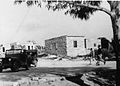
 Building on outskirts of Bayt Jibrin, 1948
 -
 Beit Jibrin police station. 1948
 -
 Beit Guvrin Police station. 1948
 -
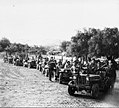 Members of the 89th Battalion outside Beit Gurvin, during Operation Yoav, October 1948


Geography[编辑]
Bayt Jibrin was situated in an area of plains and soft hills known as the Shfela (Shephelah) in Hebrew, located between the coastal plain to the west and the Hebron Hills to the east. The village was 21公里(13英里) northwest of Hebron. The average elevation of Bayt Jibrin is 275米(902英尺) above sea level. Nearby localities included the depopulated villages of Kudna to the north, al-Qubayba to the southwest, al-Dawayima to the south and the existing Palestinian towns of Beit Ula to the east and Idhna to the southeast. Historically, it was located on the main road between Cairo and Hebron, via Gaza.
拜特吉卜林位在希伯伦西北21千米处,处于一片平原低山共存的地带,在希伯来语中称为「示非拉」,[86]其平均海拔275米,西面沿海平原,东向希伯伦山。[23]其邻近居民点,就已废村落而言则北有库德纳、西南有库拜拜、南有代瓦伊马,尚存的巴勒斯坦村镇则东有拜特奥拉、东南有伊兹纳。[87]历史上,此地坐落于连接开罗希伯伦两地、经过加沙的干道之上。[88]
In 1945, Bayt Jibrin's total land area was 56.1 km2(21.7 sq mi), 98% of which was Arab-owned. The town's urban area consisted of 287 m2(0.071 acre), with 33.2 km2(8,200 acre) of cultivable land and 21.6 km2(5,300 acre) of non-cultivable land. 54.8% of the town's land was planted with cereal crops, 6.2% with olives and 4.4% with irrigated crops.
1945年,拜特吉卜林总土地面积56.1平方千米,其中98%为阿拉伯人所有。村镇城市化区域287杜纳亩,可耕种土地33.2平方千米,不可耕种土地则21.6平方千米。村镇土地中,54.8%种植谷物,6.2%种植橄榄,4.4%则为需要灌溉的作物。[2][6]
The Bayt Jibrin region contains a large number of caverns, both natural formations and caves dug in the soft chalk by inhabitants of the region over the centuries for use as quarries, burial grounds, animal shelters, workshops and spaces for raising doves and pigeons. There is estimated to be 800 such caverns, many linked by an underground maze of passageways. Eighty of them, known as the Bell Caves, are located on the grounds of the Beit Guvrin National Park.
拜特吉卜林地带有数目庞大的洞穴,既有自然形成者,亦有当地住户开凿者,千百年来当地住民在质地柔软的白垩中开凿洞窟以作采石场、墓地、畜棚、工坊等用途,同时也利用这些洞窟饲养鸽子。估计当地有此类洞穴800个,[89]其中许多都以走道形成的地下迷宫相连接。这些洞窟中有八十个称为「钟形洞窟」,位于贝特古夫林国家公园范围内。[90]
Archaeology[编辑]
Today many of the excavated areas of Maresha and Beit Guvrin can be visited as part of the Israeli Beit Guvrin-Maresha National Park. Furthermore, the Archaeological Seminars Institute, under the license of the Israel Antiquities Authority, conducts excavations of Maresha's many quarried systems, and invites visitors to participate.[來源請求]
今日马雷沙及贝特古夫林许多已发掘地段包括于以色列国贝特古夫林-马雷沙国家公园内部,可供参观。此外,有一家名为考古研讨学会的私营机构,其在以色列文物局发证许可下,对马雷沙许多采石体系进行发掘,并邀请访客参与。[91]
In 1838, the American Bible scholar Edward Robinson visited Bayt Jibrin, and identified it as ancient Eleutheropolis. The remains of the city of Maresha on Tell Sandahanna/Tel Maresha were first excavated in 1898-1900 by Bliss and Macalister, who uncovered a planned and fortified Hellenistic city encircled by a town wall with towers. Two Hellenistic and one Israelite stratum were identified by them on the mound. Between 1989 and 2000, large-scale excavations were held by the Israel Antiquities Authority (IAA) under the direction of Prof. Amos Kloner and conducted mainly in the Lower City of Maresha, concentrating both on the surface and on the subterranean complexes. Excavations continued in several subterranean complexes between 2001 and 2008.[來源請求]
1838年圣经学者爱德华·罗宾逊造访拜特吉卜林,认定当地就是古代厄琉忒罗波利斯所在。[92]马雷沙城的遗迹位于桑代汉奈土丘(马雷沙土丘)上,其首次发掘则在1898至1900年,由考古学家F·J·布利斯及R·A·S·麦卡利斯特开展。此二人发掘出一座有规划、具城防的希腊化城市,周遭环绕城墙,墙上有塔楼。二人在土丘上辨识出一层塞琉古文化层、一层以色列文化层。[93]1989至2000年间,以色列文物局在阿摩司·克洛内尔教授领导下开展大规模发掘工作,主要发掘马雷沙下城,[註 18]且对地表地底的遗迹群都有关注。此后尚有几处地底遗迹群的发掘工作自2001持续到2008年。
The largely preserved remains of the amphitheater built by the Romans were excavated by Kloner. Among other unique finds was a Roman bath that has been confirmed to be the largest in Israel and the Palestinian territories.[94] Many of the ancient city's olive presses, columbaria and water cisterns can still be seen. Less than 10 percent of the caves on Tel Maresha have been excavated.
古代罗马人修建的圆形剧场遗址保存大部完好,为克洛内尔所发掘。其他特别的发现尚有罗马浴室,经确信是以色列、巴勒斯坦两地所发现最大的一座。古城中许多橄榄油榨、纳骨堂、蓄水池今日仍可见。桑代汉奈土丘的洞穴中,仅有一成得到发掘。[95]
The ruins of three Byzantine-era churches are located in Bayt Jibrin. A church on a northern hill of the town, later used as a private residence, had elaborate mosaics depicting the four seasons which were defaced in the 1948 Arab-Israeli War. A church south of the town, known as Khirbet Sandahanna, was dedicated to Saint Anne. The New Testament does not give any information about the mother of the Virgin Mary, but the widely circulated apocryphal Gospel of James gives her name as Anne, and her birthplace as Bethlehem. In another Christian tradition though, Bayt Jibrin is the birthplace of Saint Anne. The initial Byzantine church was rebuilt by Crusaders in the 12th century. Today, the apse with its three arched windows and half-dome ceiling are still intact.
有三座东罗马时期的教堂遗址位于拜特吉卜林。一在镇北山上,后用作私人住宅,其上有精致的马赛克,描绘四季景象,而在1948年阿以战争中遭污损;[48]一在镇南,人称桑代汉奈遗址[u],奉献于圣安娜。[註 19]关于耶稣的母亲马利亚,《新约圣经》中并无任何提及其母的信息,然而在广为流传的新约外典《雅各福音》中,则记载其名为安娜,生于伯利恒。另有一种基督教传统则认为安娜生于拜特吉卜林。[94]三座教堂中第一座于十二世纪由十字军重建,今日,其后殿及半穹顶的天花板保存尚完整,后殿开有三面拱形窗。[48]
The wider area of the Shfela has been inhabited for much longer. Excavations were conducted by the Israel Antiquities Authority (IAA) about 12 kilometres northeast from Bayt Jibrin at a site located on the same wadi, Nahal Guvrin, near moshav Menuha. The IAA has unearthed there artifacts from a village believed to be 6,500 years old, placing it at the end of the Stone Age or at the beginning of the Chalcolithic or "copper-and-stone age". The finds include pottery vessels and stone tools, among them flint sickle blades, cultic objects, clay figurines of horned animals, ceramic spindle whorls and animal bones belonging to pigs, goats, sheep and larger herbivores. The inhabitants probably chose this area due to the arable land and copious springs flowing even in the rainless summer months. Archaeologists believe the villagers grew grain, as indicated by the sickle blades and the grinding and pounding tools, and raised animals that supplied milk, meat and wool, as attested to by the spindle whorls. The settlement was small in scope, approximately 1.5 dunams, but there is evidence of bartering, based on the presence of basalt vessels and other lithic objects brought to the site from afar.
示非拉地区属拜特吉卜林以外的部分,住人时间远长于此地。以色列文物局又有在拜特吉卜林东北12千米一处遗址进行发掘,此地同拜特吉卜林在同一干河(古夫林溪[v])上,靠近梅努哈莫沙夫。该局在当地一座据信有六千五百年历史的村庄出土诸多文物,将其处年代定在石器时代末期或红铜时代,即所谓「铜石并用时代」发端之时。考古发现有陶制容器,并有石器,其中包括黑燧石石镰、膜拜用具、有角动物泥塑像、陶瓷锭盘,又发现有各种动物骨骼,包括猪、山羊、绵羊乃至更大型食草动物的骨骼。当地住民选择此地,大概因其土地适宜耕种,又有丰沛泉水,即使在无降水的夏季月份仍然涌流。考古学者猜测,当年村民种植谷物,因石镰、磨具、碾具皆指向这一点;村民又饲养动物,以获取奶、肉、绒毛,而锭盘可证实有此事。此聚落规模可称为小,仅约1.5杜纳亩,然而有证据表明当地已经存在交易行为,因其处出现有玄武岩容器及其他一些石制物件,皆为自远方携来此地。[96]
Demographics[编辑]
During the Roman period, Bayt Jibrin had a mixed population of Jews, Christians and pagans. Under Muslim rule, Islam gradually became the dominant religion and by the 20th century, the entire population was Muslim.
罗马时代,拜特吉卜林人口混杂,有犹太人、基督徒及其他教徒。[30]在穆斯林统治下,伊斯兰渐而成为居主导地位的宗教,到二十世纪时,当地人口全为穆斯林。[23]
In Ottoman tax records from 1596, the town had a population of 275 inhabitants. In the late 19th century its population reached 900, while in 1896 the population was estimated to be about 1,278 persons. In 1912 it was estimated to be about 1,000, and to 1,420 in the next decade. According to the 1931 census of Palestine, Bayt Jibrin's population was 1,804. A 1945 land and population survey by Sami Hadawi reported a sharp increase to 2,430. The general growth pattern over every 9–11 years from 1912 to 1945 was around 400–500. In 1948, the projected population was 2,819.
在1596年奥斯曼征税记录中,可见拜特吉卜林镇有住民275人之人口。十九世纪时当地人口达到900人,1896年则估计有1278人。[72]1912年,人口估计有1000人,[97]后十年增长至1420人。[76]根据1931年巴勒斯坦人口普查结果,拜特吉卜林人口1804人。[77]巴勒斯坦学者萨米·赫达维在1945年进行土地人口调查,报告称人口急速升至2430人。[2]自1912年至1945年,总体人口增长呈现出每九至十一年增长四百至五百人的情态。1948年,当时预计的人口为2819人。[98]
The number of refugees from Bayt Jibrin, including their descendants, was estimated to be 17,310 in 1998. Many live in the al-'Azza (also called Bayt Jibrin) and Fawwar camps in the southern West Bank.
论及拜特吉卜林难民及其后代的数量,1998年估算其为17310人。这些难民许多生活在埃泽(又名拜特吉卜林)、福瓦尔两处难民营,均位于约旦河西岸南部。[98]
Culture[编辑]

Embroidery[编辑]
Bayt Jibrin, together with Hebron and the surrounding villages, was known for its fine Palestinian embroidery.[99] An example is a woman's jillayeh (wedding dress) from Bayt Jibrin, dated about 1900, in the Museum of International Folk Art (MOIFA) collection in Santa Fe, New Mexico. The dress is made of handwoven indigo linen with long, pointed wing-sleeves. The qabbeh ("chest-piece") is embroidered with the qelayed pattern; the maya ("water") motif, el-ferraneh ("the bakers wife") pattern, and the saru ("cypress") motif. The side panels are also covered with cross-stitch embroidery in a variety of traditional patterns.[100]
Also on show is a late 19th-century shambar (large veil) from Bayt Jibrin worn at weddings and festivals. It is made of embroidered handwoven black silk with a separate heavy red silk fringe.[101][102] A woman wore the shambar mainly on her wedding day, positioned so that when she covered her face the embroidered end would show. Another item in the collection is a headdress (iraqiyeh) embroidered with cross-stitch and decorated with Ottoman coins minted in AH 1223 (1808), as well as Maria Theresa coins. The iraqiyeh was worn by married women and elaborate pieces were passed down as family heirlooms. Long embroidered headbands made of cotton hanging from both sides were wrapped around the woman's braids to facilitate the bundling of her hair, then secured to the back of the headdress.[103]
Shrines[编辑]

In Islamic tradition, Bayt Jibrin is the burial place of the sahaba (companion) of the prophet Muhammad, Tamim al-Dari,[23] who was famously known for his piety and briefly served as the governor of Jerusalem in the late 7th century. Al-Dari and his family were granted trusteeship over the Hebron Hills, including Bayt Jibrin, and were assigned as the supervisors of the Cave of the Patriarchs (Ibrahimi Mosque) in Hebron. His sanctuary is the most venerated site in Bayt Jibrin, located just northwest of it. Until the present day, al-Dari's sanctuary has been a place of local Muslim pilgrimage.[105] Other Islamic holy sites in the village include Maqam for a local shaykh named Mahmud and a tomb for a shaykha (female religious figure) named Ameina.[87]
See also[编辑]
- Beit Guvrin-Maresha National Park
- Ibelin, Crusader castle at Tel Yavne on the Mediterranean coastal plain
- Justus of Eleutheropolis
- Kibbutz Beit Guvrin
- Depopulated Palestinian locations in Israel
- List of villages depopulated during the Arab-Israeli conflict
- Maresha
- National Parks of Israel
- Peter of Eleutheropolis
- Zebennus
注释[编辑]
释音[编辑]
- ^ 阿拉伯语:بَيْت جِبْرِين,羅馬化:Bayt Jibrīn,希伯來語:בֵּית גּוּבְרִין,羅馬化:Bet Guvrin,「贝特古夫林」[註 1]
- ^ 希伯來語:מָרֵשָׁה,羅馬化:Mareshah
- ^ 又名埃泽,阿拉伯语:العَزَّة,羅馬化:al-‘Azzah
- ^ 阿拉伯语:الفَوَّار,羅馬化:al-Fawwār
- ^ 阿拉伯语:بيت جبرين,羅馬化:Byt Jbryn,只标记辅音
- ^ 阿拉伯语:تَلّ صَندَحَنَّة,羅馬化:Tall Ṣandaḥannah
- ^ 希伯來語:תֵּל מָרֵשָׁה,羅馬化:Tel Mareshah
- ^ 希伯來語:יְהוּדָה בֶּן-יַעֲקֹב,羅馬化:Yehudah ben-Ya‘aḳov
- ^ 希伯來語:יוֹנָתָן מֵבֵּית גּוּבְרִין,羅馬化:Yonatan me-Bet Guvrin
- ^ 希伯來語:דָּרוֹם,羅馬化:Darom
- ^ 阿拉伯语:الداروم,羅馬化:al-Dārūm
- ^ 希伯來語:וָאדִי אל־עונקור,羅馬化:Wadi el-‘Unḳur
- ^ 阿拉伯语:إذنا,羅馬化:Idna
- ^ 阿拉伯语:عَجْلَان,羅馬化:‘Ajlān
- ^ 波斯語:سَفَرنامه,羅馬化:Safarnāmah
- ^ 阿拉伯语:العَزَّة,羅馬化:al-‘Azzah
- ^ 阿拉伯语:قَيْس,羅馬化:Qays
- ^ 阿拉伯语:یَمَان,羅馬化:Yamān
- ^ 阿拉伯语:آل أَبُو غوش,羅馬化:Āl Abū Ghawsh
- ^ 阿拉伯语:مُصْلِح العَزَّة,羅馬化:Muṣliḥ al-‘Azzah,人称「拜特吉卜林巨人」
- ^ 阿拉伯语:خِرْبَة صَندَحَنَّة,羅馬化:Khirbat Ṣandaḥannah
- ^ 希伯來語:נַחַל גּוּבְרִין,羅馬化:Naḥal Guvrin
释事[编辑]
- ^ 一作「伯姑林」。[5]
- ^ 约瑟夫斯《犹太战史》的原文是希腊文。
- ^ Ius Italicum,授予不在意大利的城市以等同意大利城市的权利。
- ^ 「古卜林」一作「古夫林」。
- ^ Betaris,当作「柏伽布里斯」(Begabris)。[27]
- ^ 罗马人在犹太圣城耶路撒冷废墟上建立的殖民地。
- ^ Ὀνομαστικόν,又译「圣经地名汇编」「地理志」等,该词的本义是指一种列举专有名词(尤其是人名)的书籍。
- ^ Itinerarium,古罗马一种旅途指南,列举行程所经各地及相距里程。
- ^ 即《使徒行傳》第1章第23节参中提到「叫作巴撒巴又称呼犹士都的约瑟」。
- ^ 亞拉姆語:תַּנָּא,罗马化:Tana,《密释纳》成书前的犹太口传律法学者。
- ^ 亞拉姆語:אֲמוֹרָא,罗马化:Amora,对《密释纳》作评注的拉比。
- ^ 约合今14.7英里。
- ^ 希伯來語:מִדְרָשׁ רַבָּה,羅馬化:Midrash Rabah,「米德拉什」指犹太教对犹太教律法及伦理作出解释的圣经注释,分「哈拉卡」「哈加达」两种;「拉巴」本义为「大」,此指哈加达米德拉什中对妥拉及五书卷进行注释的部分,中文有译作「大注释书」者。
- ^ 阿拉伯语:جُنْد فِلَسْطِيْن,羅馬化:Jund Filasṭīn,这里的「军区」为意译,指哈里发国早期在所征服领土的阿拉伯武装殖民地基础上设置的军事分区,此类分区尤以黎凡特地区所设者为著名。
- ^ 亨利二世拒绝称王,故称「耶路撒冷王国之主」。
- ^ 哈利勒即希伯伦,纳希耶(阿拉伯语:نَاحِيَة,羅馬化:nāḥiyah)是一种行政区划,在奥斯曼帝国次于卡扎(县)和桑贾克(旗)。新疆维吾尔自治区的「县」(維吾爾語:ناھىيىسى,拉丁维文:Nahiyisi)与之是同源词。
- ^ 「宝座村」(阿拉伯语:قَرْيَة الْكُرْسِي,羅馬化:qaryat al-kursī)指巴勒斯坦中部山区一些谢赫家族作政治军事驻地使用的村庄,此类村庄尤以奥斯曼帝国后半叶出现者为多。
- ^ 马雷沙分上下两城,上城位于桑代汉奈土丘顶部,即布利斯、麦卡利斯特二人发掘出的希腊化城市;下城位于底部,环绕上城。[26]
- ^ 「桑代汉奈」是「圣安娜」在阿拉伯语中的讹称。「安娜」在希伯来语中为חַנָּה,罗马化:Ḥanah。
References[编辑]
- ^ 1.0 1.1 Department of Statistics, 1945, p. 23 互联网档案馆的存檔,存档日期2015-12-22.
- ^ 2.0 2.1 2.2 2.3 2.4 Village Statistics, Government of Palestine. 1945. Quoted in Hadawi 1970,第50頁 互联网档案馆的存檔,存档日期2011-06-04.
- ^ Morris 2004,第xix頁,village #322. Also gives the cause of depopulation.
- ^ 4.0 4.1 Morris 2004,第xxii頁,settlement #166.
- ^ 伯姑林/瑪利沙. 聖光聖經地理資訊網. 2015-07-21 [2024-06-07].
- ^ 6.0 6.1 6.2 Village Statistics, Government of Palestine. 1945. Quoted in Hadawi 1970,第143頁 Archive.is的存檔,存档日期2013-01-31
- ^ Ben-Yosef 1980,第255頁,Beit Gubrin,本节由Meron Benvenishti撰写,Nadav Lepinski编辑
- ^ Zissu, B., Ecker, A., and Klein, E, 2017, "Archaeological Explorations North of Bet Guvrin (Eleutheropolis)", in: Speleology and Spelestology, Proceedings of the VIII International Scientific Conference. Nabereznye Chelny, pp. 183-203.
- ^ Region of the Caves & Hiding: bet Guvrin-Maresha 互联网档案馆的存檔,存档日期2017-10-27.. UNESCO World Heritage Centre.
- ^ Eleutheropolis in Palaestina (Titular See)
- ^ 11.0 11.1 11.2 Sharon 1999,第109頁, following Robinson & Smith 1856,第28頁,nn, 1 and 6
- ^ Peters & Theirsch 1905,第7頁.
- ^ The Protestant Theological and Ecclesiastical Encyclopedia (1860) By John Henry Augustus Bomberger, Johann Jakob Herzog p 178
- ^ Schlatter, A. Die hebräischen Namen bei Josephus. Beiträge zur Förderung christlicher Theologie (Gütersloh: Bertelsmann). 1913, 17 (3/4) (德语)., s.v. Betabrin. Cf. The Jewish Wars Josephus Flavius IV:447. Note: Page 270 in the 1981 Penguin Classics edition.
- ^ 15.0 15.1 Robinson & Smith 1856,第67頁
- ^ 16.0 16.1 Macalister, R.A. Stewart. Eleutheropolis. Chisholm, Hugh (编). Encyclopædia Britannica 9 (第11版). London: Cambridge University Press: 263. 1911.
- ^ 17.0 17.1 Negev, Avraham; Gibson, Shimon. Archaeological Encyclopedia of the Holy Land. Continuum. 2001: 78. ISBN 978-0-8264-1316-1.
- ^ Murphy-O'Connor, Jerome. The Holy Land: An Oxford Archaeological Guide from Earliest Times to 1700. OUP Oxford. 28 February 2008: 217–ff. ISBN 978-0-19-152867-5.
- ^ 19.0 19.1 Richard 1921,第140頁.
- ^ 20.0 20.1 The Guide to Israel, Zev Vilnay, Hamakor Press, Jerusalem 1972, p.276
- ^ 21.0 21.1 Khalidi 1992,第209-210頁.
- ^ Avraham Negev and Shimon Gibson (editors), Archaeological Encyclopedia of the Holy Land, Continuum 2001, p 315.
- ^ 23.0 23.1 23.2 23.3 23.4 23.5 23.6 Khalidi 1992,第209頁
- ^ Nashashibi, 1997, Bayt Jibrin Before 1948 Center for Research and Documentation of Palestinian Society, Birzeit University.
- ^ Regev, Dalit. The Power of the Written Evidence: A Hellenistic Burial Cave at Marisa. Mediterranean Archaeology (Meditarch). 2017, 30: 19–50. JSTOR 26727142 (英语).
- ^ 26.0 26.1 Kloner, Amos; Zissu, Boaz. The Subterranean Complexes of Maresha: An Urban Center from the Hellenistic Period in the Judean Foothills, Israel. Opera Ipogea. 2013, 15 (2): 45–62.
- ^ Robinson & Smith 1856,第67頁,nn. 7, citing Reland who cites in turn Tyrannius Rufinus, based on his Latin translation of Josephus' The Jewish War (4.8.1.).
- ^ Josephus, De Bell. Jud., IV.viii.1 互联网档案馆的存檔,存档日期2016-03-06.
- ^ 29.0 29.1 Beit Guvrin, Maresha caves now world heritage site. San Diego Jewish World. 23 June 2014. (原始内容存档于17 June 2015).
- ^ 30.0 30.1 30.2 30.3 30.4 Kloner 1999
- ^ Sharon 1999,第111頁.
- ^ Murphy-O'Connor, Jerome. The Holy Land: An Oxford Archaeological Guide from Earliest Times to 1700. OUP Oxford. 28 February 2008: 217–. ISBN 978-0-19-152867-5.
- ^ 33.0 33.1 33.2 33.3
 本條目包含已處於公共領域的Vailhé, Siméon. Eleutheropolis. Herbermann, Charles (编). 天主教百科全書 5. Robert Appleton Company: 380. 1909.
- ^ Jerusalem Talmud, Demai 2:1. Since the region of Beit Jibrin (Eleutheropolis) was typically seen as not settled by Jews returning from the Babylonian captivity, it therefore had not the same consecrated status as other areas of the country, making its Jewish citizens exempt from tithing home-grown produce.
- ^ The Panarion of Epiphanius of Salamis: Book I (Sects 1-46) By Epiphanius, Epiphanius of Salamis, Translated by Frank Williams BRILL, (1987) ISBN 90-04-07926-2 p xi
- ^ Safrai, Zeev (1994) The Economy of Roman Palestine Routledge, ISBN 0-415-10243-X p 257
- ^ Places of Section 6: Mountain of Judah and Shephelah:84. Eleutheropolis - (Bayt Jibrin). [5 August 2012]. (原始内容存档于15 July 2012). Madaba Map Online
- ^ Anonymus Placentinus Itinerarium 32
- ^ Lieu, Samuel N.C. Manichaeism in the Later Roman Empire and Medieval China: a Historical Survey. Pages 68-69. Manchester University Press, 1985.
- ^ 40.0 40.1 "Encyclopedia Judaica", Bet Guvrin, p.731, Keter Publishing, Jerusalem, 1978
- ^ Al-Muqaddasi, Description of Syria, Including Palestine, ed. Guy Le Strange, London 1886, p. 53
- ^ Ben-Yosef 1980,第196-198頁,Wādi el-ʻUnqur,本节由David Amit撰写
- ^ 43.0 43.1 Conder & Kitchener 1883,第257頁
- ^ Freedman, Harry; Simon, Maurice (编). Midrash Rabbah. 2: Genesis. 由Freedman, Harry翻译. London: Soncino Press. 1939: 610 (英语).
And of the dew of heaven from above (ib.), to Beth Gubrin.
[「天上的甘露(《創世記》第27章第39节参)」(同上节),指贝特古卜林。] - ^ The conquered towns included "Ghazzah (Gaza), Sabastiyah (Samaria), Nabulus (Shechem), Kaisariyyah (Cæsarea), Ludd (Lydda), Yubna, Amwas (Emmaus), Yafa (Joppa), Rafah, and Bait Jibrin". (Bil. 138), quoted in Le Strange, 1890, p.28 互联网档案馆的存檔,存档日期2011-06-29.
- ^ Sharon 1999,第115頁. Quoting al-Baladhuri, al-Waqidi and Yaqut al-Hamawi.
- ^ Gil, Moshe; Broido, Ethel, A history of Palestine, 634-1099, Cambridge University Press: 283, 1997, ISBN 978-0-521-59984-9
- ^ 48.0 48.1 48.2 Eleutheropolis - (Bayt Jibrin) 互联网档案馆的存檔,存档日期2016-03-06. Studium Biblicum Franciscanum - Jerusalem. 2000-12-19.
- ^ Muk., 174, quoted in Le Strange, 1890, p.412 互联网档案馆的存檔,存档日期2011-06-29.
- ^ Al-Muqaddasi 1994,第157頁
- ^ Zissu, Boaz; Kloner, Amos. The Bell-Shaped Quarries of the Judean Foothills, Israel. Opera Ipogea. 2014, 16 (2): 47–60.
- ^ Sharon 1999,第120-121頁.
- ^ Richard 1921,第96頁.
- ^ The Fall of the Latin Kingdom of Jerusalem, Joshua Prawer, Israel Argosy, p.186, Jerusalem Post Press, Jerusalem, 1956
- ^ Robinson & Smith 1856,第29頁
- ^ Sharon 1999,第121頁.
- ^ Richard 1921,第230頁.
- ^ Sharon 1999,第121-122頁.
- ^ 59.0 59.1 Sharon 1999,第122頁.
- ^ Hütteroth & Abdulfattah 1977,第149頁
- ^ Darwaza, Muhammad ´Izzat. Al -´arab wa-l-´uruba min al-qarn al-thalit hatta al-qarn al-rabi´ ´ashar al-hijri, vol 2 (Damascus, 1960), pp 138-140, quoted in Schölch 1993,第189頁.
- ^ 62.0 62.1 Sharon 1999,第123-124頁.
- ^ Schölch 1993,第234-235頁. Note 708 states that there is more information about them in Finn, Byeways in Palestine 互联网档案馆的存檔,存档日期2012-11-09., pp. 176-183 (in 1849 an elderly fellah from the district asked Finn to inform the sultan in Constantinople of the cruel harassment of the peasants by Muslih al-´Azza and his family.)
- ^ 64.0 64.1 64.2 Schölch 1993,第236-237頁.
- ^ Finn 1878,第305-308頁
- ^ Robinson & Smith 1841,第360頁,另见同页注释4,引提尔的威廉:“Urbem veterem et dirutam ... Arabice Bethgebrim”
[将古老而废弃的城……在阿拉伯语称「柏特革布林」] - ^ Van de Velde, 1854, vol. 2, p. 157; Conder and Kitchener, 1883, SWP III, p. 257, p. 266; Guérin, 1869, p. 331. All quoted in Schölch 1993,第189頁.
- ^ Furrer, Konrad: Wanderungen durch das Heilige Land, Zurich, 1891, pp 118-25. Quoted in Schölch 1993,第189頁.
- ^ Trisdam 1865,第378頁
- ^ Socin 1879,第146頁
- ^ Hartmann 1883,第143頁 noted 148 houses
- ^ 72.0 72.1 Schick 1896,第126頁 互联网档案馆的存檔,存档日期2016-03-12.
- ^ The Palestine Theatre, 1915-1918. (原始内容存档于11 June 2011).
- ^ An Empire in the Holy Land: Historical Geography of the British Administration in Palestine, 1917-1929 Gideon Biger, St. Martin's Press, 1994
- ^ Palestine, E. Quarterly Statement for 1875. London. 1822: 152.
- ^ 76.0 76.1 Barron, 1923, Table V, Sub-district of Hebron, p. 10
- ^ 77.0 77.1 Mills 1932,第28頁
- ^ UN Archives[永久失效連結] REPORT by His Majesty's Government in the United Kingdom of Great Britain and Northern Ireland to the Council of the League of Nations on the Administration of Palestine and Trans-Jordan for the year 1938
- ^ Village Statistics, Government of Palestine. 1945. Quoted in Hadawi 1970,第93頁 Archive.is的存檔,存档日期2012-09-07
- ^ Map of UN Partition Plan. United Nations. [6 December 2007]. (原始内容存档于1 December 2007).
- ^ NYT, 4/5/48, quoted in Khalidi 1992,第209-210頁.
- ^ Morris 2004,第465頁.
- ^ Morris 2004,第414, 468頁.
- ^ 84.0 84.1 Morris 2004,第468頁.
- ^ Palestinian Refugees - A Personal Story. Badil. (原始内容存档于27 September 2007).
- ^ Ben-Arieh, Yehoshua. Pits and Caves in the Shephelah of Israel compared with Similar Pits in East Anglia. Geography. 1969, 54 (2): 186–192. JSTOR 40566784.
- ^ 87.0 87.1 Abu-Sitta 2007,第117頁
- ^ Sharon 1999,第117頁.
- ^ Gems in Israel: Bell Cave at Beit Guvrin. (原始内容存档于29 January 2009).
- ^ Israel Nature and National Parks Protection Authority. (原始内容存档于28 August 2009).
- ^ . Archaeological Seminars Institute https://www.digforaday.com/. [2024-06-13]. 缺少或
|title=为空 (帮助) - ^ Biblical researches in Palestine, 1838-52. A journal of travels in the year 1838. P. 57ff: Eleutheropolis 互联网档案馆的存檔,存档日期2011-05-20. 1856,
- ^ Bliss, Macalister & Wünsch 1902,第52-61頁,The Excavations at Tell Sandaḥannah.
- ^ 94.0 94.1 Sharon 1999,第14頁.
- ^ Gerszberg, Caren Osten. Amateur Archaeologists Get the Dirt on the Past. The New York Times. 16 July 2006. (原始内容存档于11 October 2017).
- ^ A 6,500-year-old farming village was exposed in excavations that are being conducted along the route of the national gas carrier in the fields of Moshav Menuha - near Nahal Guvrin. Israel Antiquities Authority. 24 April 2006. (原始内容存档于5 February 2009).
- ^ Baedecker, in his handbook, 1912, p.116-117, quoted in Khalidi 1992,第209頁
- ^ 98.0 98.1 Welcome to Bayt Jibrin. Palestine Remembered. [6 December 2007].
- ^ Palestinian costume before 1948 - by region Palestine Costume Archive. Retrieved on 01.15.2008.
- ^ Stillman 1979,第58-59頁,有插图.
- ^ Stillman 1979,第66頁,有插图.
- ^ Stillman 1979,插图15,第33页对侧.
- ^ Weir 1989,第184頁
- ^ Petersen 2001,第122頁
- ^ Sharon 1999,第140-141頁.
Bibliography[编辑]
- Abu-Sitta, S. The Return Journey. London: Palestine Land Society. 2007. ISBN 978-0-9549034-1-1.
- Al-Muqaddasi. The Best Divisions for Knowledge of the Regions. 由Basil Anthony Collins翻译. Reading: Garnet Publishing. 1994. ISBN 1-873938-14-4.
- Ben-Yosef, Sefi (编). מדריך ישראל : אנציקלופדיה שימושית לידיעת הארץ [以色列指南:了解国土知识有用的百科全书] 9. Jerusalem: Keter Publishing House. 1980. OCLC 745203905 (希伯来语).
- Barron, J. B. (编). Palestine: Report and General Abstracts of the Census of 1922. Government of Palestine. 1923.
- Bliss, Frederick Jones; Macalister, Robert Alexander Stewart; Wünsch, Richard. Excavations in Palestine During the Years 1898-1900 2. London: Committee of the Palestine Exploration Fund. 1902.
- Blumberg, Arnold. A View from Jerusalem, 1849-1858. The Consular Diary of James and Elisabeth Anne Finn. Associated University Presses. 1980. ISBN 0-8386-2271-2.
- Conder, C.R.; Kitchener, H.H. The Survey of Western Palestine: Memoirs of the Topography, Orography, Hydrography, and Archaeology 3. London: Committee of the Palestine Exploration Fund. 1883.
- Dauphin, C. La Palestine byzantine, Peuplement et Populations. BAR International Series 726. III: Catalogue. Oxford: Archeopress. 1998. ISBN 0-860549-05-4 (French).
- Finn, J. Byeways in Palestine. London: James Nisbet. 1877. Search for "Bait Jibreen" (Spring 1849: pp. 176, 178-182, stay at Bait Jibreen, at the house of the brother of the sheik)(Spring 1853, note 182: fighting in Bayt Jibreen, at least 35 killed.)
- Finn, J. Finn, E. A. , 编. Stirring Times, or, Records from Jerusalem Consular Chronicles of 1853 to 1856. Edited and Compiled by His Widow E. A. Finn. With a Preface by the Viscountess Strangford 2. London: C.K. Paul & co. 1878.
- Furrer, Konrad. Wanderungen durch Palästina. Orell, Fussli und comp: 97ff. 1865. Later edition quoted in Schölch
- Guérin, V. Description Géographique Historique et Archéologique de la Palestine. 1: Judee, pt. 2. Paris: L'Imprimerie Nationale. 1869 (French).
- Hadawi, S. Village Statistics of 1945: A Classification of Land and Area ownership in Palestine. Palestine Liberation Organization Research Center. 1970 [2 June 2008]. (原始内容存档于8 December 2018). 已忽略未知参数
|df=(帮助) - Hartmann, M. Die Ortschaftenliste des Liwa Jerusalem in dem türkischen Staatskalender für Syrien auf das Jahr 1288 der Flucht (1871). Zeitschrift des Deutschen Palästina-Vereins. 1883, 6: 102–149.
- Hütteroth, Wolf-Dieter; Abdulfattah, Kamal. Historical Geography of Palestine, Transjordan and Southern Syria in the Late 16th Century. Erlanger Geographische Arbeiten, Sonderband 5. Erlangen, Germany: Vorstand der Fränkischen Geographischen Gesellschaft. 1977. ISBN 3-920405-41-2.
- Josephus. The Jewish War. Penguin Classics. 由Williamson, G.A.翻译 Revised. Penguin Books. 1981 [First published 1959]. ISBN 0-14-044420-3. with Introduction, notes and appendices by E. Mary Smallwood.
- Khalidi, W. All That Remains: The Palestinian Villages Occupied and Depopulated by Israel in 1948. Washington D.C.: Institute for Palestine Studies. 1992. ISBN 0-88728-224-5.
- Kloner, Amos. The City of Eleutheropolis. The Madaba Map Centenary 1897-1997. Jerusalem. 1999: 244–246. (原始内容存档于2005-04-13).
- Le Strange, G. Palestine Under the Moslems: A Description of Syria and the Holy Land from A.D. 650 to 1500. Committee of the Palestine Exploration Fund. 1890.
- Mills, E. (编). Census of Palestine 1931. Population of Villages, Towns and Administrative Areas. Jerusalem: Government of Palestine. 1932.
- Morris, B. The Birth of the Palestinian Refugee Problem Revisited. Cambridge University Press. 2004. ISBN 978-0-521-00967-6.
- Morris, B. 1948: A History of the First Arab-Israeli War. Yale University Press. 2008. ISBN 9780300126969.
- Palmer, E.H. The Survey of Western Palestine: Arabic and English Name Lists Collected During the Survey by Lieutenants Conder and Kitchener, R. E. Transliterated and Explained by E.H. Palmer. Committee of the Palestine Exploration Fund. 1881.
- Peters, J.P.; Theirsch, H. Painted Tombs in the necropolis of Marissa (Marêshah). London: Palestine Exploration Fund. 1905: 7. ISBN 9780790530994.
- Petersen, Andrew. A Gazetteer of Buildings in Muslim Palestine (British Academy Monographs in Archaeology) 1. Oxford University Press. 2001. ISBN 978-0-19-727011-0.
- Pringle, D. The Churches of the Crusader Kingdom of Jerusalem: A-K (excluding Acre and Jerusalem) I. Cambridge University Press. 1993. ISBN 0-521-39036-2.
- Pringle, D. Secular buildings in the Crusader Kingdom of Jerusalem: an archaeological Gazetter. Cambridge University Press. 1997. ISBN 0521-46010-7.
- Richard, Jean. Histoire des croisades [The Crusades c. 1071—c. 1291]. 由Birrell, Jean翻译. Cambridge University Press. 1921. ISBN 0-521-62566-1. 2001年重印
- Robinson, E.; Smith, E. Biblical Researches in Palestine, Mount Sinai and Arabia Petraea: A Journal of Travels in the year 1838 2. Boston: Crocker & Brewster. 1841. Visited "Beit Jibrin" in 1838.
- Robinson, E.; Smith, E. Biblical Researches in Palestine, and in the Adjacent Regions. Journal of Travels in the Year 1838 2. London / Boston: Crocker & Brewster. 1856: 67 (note 7). OCLC 425957927.
- Schick, C. Zur Einwohnerzahl des Bezirks Jerusalem. Zeitschrift des Deutschen Palästina-Vereins. 1896, 19: 120–127.
- Schölch, Alexander. Palestine in Transformation, 1856-1882. Institute for Palestine Studies. 1993. ISBN 0-88728-234-2.
- Sharon, M. Corpus Inscriptionum Arabicarum Palaestinae, B-C 2. BRILL. 1999. ISBN 90-04-11083-6.
- Sharon, M. Corpus Inscriptionum Arabicarum Palaestinae, D-F 3. BRILL. 2004. ISBN 90-04-13197-3. (Bayt Jibrin p. xxxiv)
- Socin, A. Alphabetisches Verzeichniss von Ortschaften des Paschalik Jerusalem. Zeitschrift des Deutschen Palästina-Vereins. 1879, 2: 135–163.
- Stillman, Yedida Kalfon. Palestinian Costume and Jewelry. Albuquerque: University of New Mexico Press. 1979. ISBN 0-8263-0490-7.
- Thomson, W.M. The Land and the Book: Or, Biblical Illustrations Drawn from the Manners and Customs, the Scenes and Scenery, of the Holy Land 2 1st. New York: Harper & brothers. 1859: 358–360, 371, 375.
- Tristram, H.B. Land of Israel, A Journal of travel in Palestine, undertaken with special reference to its physical character. London: Society for Promoting Christian Knowledge. 1865. (Mohammed Isa of Bayt Jibrin: February–April 1864, p. 374, p. 377, p. 378, p. 381 and p. 506)
- Velde, van de, C.W.M. Narrative of a journey through Syria and Palestine in 1851 and 1852 2. William Blackwood and son. 1854. (Search for "Beit Jebrin" og "Mosleh-el-Hasy": p. 72, 73, 138, 139, 142, 147–154, 157, 185, 190, 191)
- Village Statistics, April, 1945. Government of Palestine. 1945.
- Weir, Shelagh. Palestinian Costume (exhibition catalog). London: British Museum Publications. 1989. ISBN 0-7141-2517-2.
External links[编辑]
- Welcome To Bayt Jibrin
- Bayt Jibrin, Zochrot
- Survey of Western Palestine, Map 20: IAA, Wikimedia commons
- Bayt Jibrin from the Khalil Sakakini Cultural Center.
- Bayt Jibrin by Rami Nashashibi (1996), Center for Research and Documentation of Palestinian Society.
- The Imaginary Village by Sandy Tolan & Melissa Robbins
- Testimony: Army demolishes village housing over 200 Palestinians, west of the Barrier, Oct. 2007, Btselem
- Army demolishes village housing over 200 Palestinians, west of the Barrier, 25 November 2007, Btselem
- Edward Robinson: Biblical researches in Palestine, 1838-52. A journal of travels in the year 1838. (1856) p. 57ff: Eleutheropolis
 Eleutheropolis. Encyclopædia Britannica VIII 9th: 128. 1878.
- Amos Kloner, 1999. "The City of Eleutheropolis": in The Madaba Map Centenary 1897-1997, (Jerusalem) pp 244–246. Eleutheropolis in the late Roman and Byzantine period
- Archaeological World: Eleutheropolis
- Catholic Encyclopedia 1908, s.v. "Eleutheropolis"
- Jewish Encyclopedia: "Eleutheropolis"
- pictures of Eleutheropolis
- Early pictures of mosaics at Eleutheropolis, many now in Istanbul:
- Mosaic of warrior, (approximately 1900 to 1926)
- Mosaic of tethered horse, (approximately 1900 to 1926)
- Another view of mosaic floor, (approximately 1900 to 1926)
- Mosaic of Greek inscription, (approximately 1900 to 1926)
- Mosaic of maiden with fruit, (approximately 1900 to 1926)
- Mosaic of maiden with fruit, (approximately 1900 to 1926)
Template:Palestinian Arab villages depopulated during the 1948 Palestine War Template:Crusader sites
- Arab villages depopulated during the 1948 Arab–Israeli War
- Castles and fortifications of the Kingdom of Jerusalem
- Castles and fortifications of the Knights Hospitaller
- Castles in Israel
- Catholic titular sees in Asia
- District of Hebron
- Former populated places in Southwest Asia
- History of Palestine (region)
- Mandatory Palestine
- Throne villages
- Talmud places
- Archaeological sites in Israel
- Roman sites in Israel
- 200s establishments in the Roman Empire
- 8th-century disestablishments in the Abbasid Caliphate
- 790s disestablishments