
烏托邦平原
 海盜2號着陸器在烏托邦平原拍攝的晨霜狀冰凍(偽色) | |
| 位置 | 埃忒里亞西北的伊希斯平原東北部 |
|---|---|
| 坐標 | 46°42′N 117°30′E / 46.7°N 117.5°E座標:46°42′N 117°30′E / 46.7°N 117.5°E |
烏托邦平原(Utopia Planitia)是火星烏托邦區一處廣袤的平原[1],是火星[a]及太陽系中公認最大的撞擊盆地,直徑估計達3300公里[3]。它坐落在火星卡西烏斯區、阿蒙蒂斯區和刻布壬尼亞區之間,位於阿耳古瑞平原的對跖點上,其中心坐標為46°42′N 117°30′E / 46.7°N 117.5°E[1]。1976年9月3日美國海盜2號着陸器和2021年5月14日中國天問一號任務中祝融號火星車分別着陸在該火星區域並進行了探測[4][5]。
托邦平原上的許多岩石似乎都散鋪在表面,仿佛風吹走了它們下方大部分的土壤[6][7]。上涌的地下礦物溶液在表面蒸發形成一層堅硬的表層地殼[8],部分區域表面顯示出像用冰淇淋勺挖出的扇形地形,這種表面被認為是由富含水冰的永久凍土層退化而成[9]。在烏托邦平原(約北緯35–50度、東經80–115度),很多特徵看上去類似地球上所發現的冰核丘[10]。
2016年11月22日,美國宇航局報告稱,在烏托邦平原地區發現了大量地下冰。據估計,檢測到的水量相當於一座蘇必利爾湖[11][12][13]。
扇形地形[編輯]


扇形地形常見於火星南北45度到60度之間的中緯度地區,其中在北半球的烏托邦平原地區[14][15]和南半球的佩紐斯和安菲特里忒破火山口地區[16][17]尤為突出。這種地形由帶扇貝或荷葉狀邊緣、無隆起邊壘的低淺窪地構成,通常稱為扇形窪地或簡稱貝狀。扇形窪地可能孤立,也可能聚集,有時似乎會合併在一起。一處典型的扇形窪地顯示出一側面向赤道的緩坡和另一側面向極地的陡坡,這種不對稱地形可能是因日照差異所造成。扇形窪地被認為是升華造成的地下物質(可能是間隙冰)流失而形成,這一過程至今可能仍在發生[18]。
-
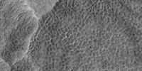
![HiWIsh計劃下高分辨率成像科學設備顯示的扇形狀地面,發表在《伊卡洛斯》雜誌上的一項研究發現,在當前火星氣候條件下,水冰升華造成的地下損耗可形成扇形地貌。他們的模型預測,當地下藏有大量深達數十米的純冰時,可能會出現類似形狀[19]。](//upload.wikimedia.org/wikipedia/commons/thumb/9/95/ESP_037461_2255scallopstop.jpg/190px-ESP_037461_2255scallopstop.jpg) HiWIsh計劃下高分辨率成像科學設備顯示的扇形狀地面,發表在《伊卡洛斯》雜誌上的一項研究發現,在當前火星氣候條件下,水冰升華造成的地下損耗可形成扇形地貌。他們的模型預測,當地下藏有大量深達數十米的純冰時,可能會出現類似形狀[19]。
HiWIsh計劃下高分辨率成像科學設備顯示的扇形狀地面,發表在《伊卡洛斯》雜誌上的一項研究發現,在當前火星氣候條件下,水冰升華造成的地下損耗可形成扇形地貌。他們的模型預測,當地下藏有大量深達數十米的純冰時,可能會出現類似形狀[19]。 -
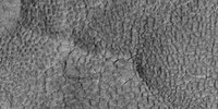
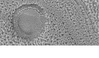
 HiWIsh計劃下高分辨率成像科學設備顯示的扇形地面特寫。表面被劃分成多邊形,這些形狀在地表凍結和融化的地區很常見。註:這是前一幅圖像的放大版。
 -
 HiWIsh計劃下高分辨率成像科學設顯示的扇形地面。
 -
 HiWIsh計劃下高分辨率成像科學設備拍攝的扇形地面特寫。表面被劃分成多邊形,這些形狀在地表凍結和融化的地區很常見。註:這是前一幅圖像的放大版。
![HiWIsh計劃下高分辨率成像科學設備顯示的扇形狀地面,發表在《伊卡洛斯》雜誌上的一項研究發現,在當前火星氣候條件下,水冰升華造成的地下損耗可形成扇形地貌。他們的模型預測,當地下藏有大量深達數十米的純冰時,可能會出現類似形狀[19]。](/wiki/File:ESP_037461_2255scallopstop.jpg)


底座形撞擊坑[編輯]
-

-
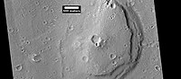
 前一幅底座形撞擊坑照片的東部(右側)特寫,顯示了垂坡上的多邊形圖案。由於隕坑邊緣有垂坡和多邊形,據信在保護層下面存在有水冰。註:這是前一幅圖像的放大版。


多邊形圖案地面[編輯]
多邊形、圖案狀的地面在火星的某些地區很常見[20][21][22][23][24][25]。通常認為是由地表冰升華所引起的。升華是固體冰直接轉變為氣體,類似與地球上的乾冰。火星上顯示多邊形地面的地方可能表明未來定居者可在那裡找到水冰。覆蓋層形成的圖案地面,稱為緯度相關覆蓋層,是在氣候不同時,從天空中飄落的冰塵顆粒所形成[26][27][28][29]。
-

-
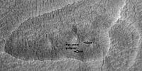 HiWish計劃下高分辨率成像科學設備顯示的卡西烏斯區圖案地面,箭頭指示了中央凸起的多邊形。該圖像使用HiView放大。
 -
 HiWIsh計劃下高分辨率成像科學設備顯示的卡西烏斯區地面,標註為中央下凹和中央凸起多邊形的扇形地形。該圖像使用HiView放大。
 -
 HiWIsh計劃下高分辨率成像科學設備顯示的卡西烏斯區中央下凹多邊形地面,圖像使用HiView放大。
 -
 HiWIsh計劃下高分辨率成像科學設備顯示的卡西烏斯區中央凸起和中央下凹的多邊形地面,圖像使用HiView放大。


烏托邦平原的其他特徵[編輯]
-
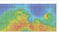 顯示烏托邦及周邊其他地區邊界的激光高度計地圖
 -
 HiWish計劃下高分辨率成像科學設備顯示的烏托邦平原隕坑坑底上的凹洞和窪陷,這些形狀可能是冰離開地面後所造成。
 -

-
 HiWish計劃下高分辨率成像科學設備顯示的層狀桌山。
 -
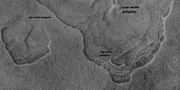
 背景相機拍攝的下一幅圖像的背景圖:赫拉德谷分層,照片顯示了岩層、流線型體和指示水流方向的箭頭。
 -
 HiWIsh計劃下高分辨率成像科學設備顯示的沿赫拉德谷暴露的分層。


圖集[編輯]

流行文化[編輯]
在《星際迷航》電視連續劇中,位於火星表面和上方非同步軌道中的烏托邦平原是星際聯邦的一座大型造艦基地[30],在那裡建造了企業號、挑戰號、航海者號和聖保羅號等星艦[30]。
烈焰紅唇組合在2002年發行的專輯《良美大戰粉紅機器人》中的一首歌曲「乘氣球靠近帕弗尼斯山(烏托邦平原)」亦是以該地區為題。
火星交互地圖[編輯]

另請查看[編輯]
注釋[編輯]
參考文獻[編輯]
- ^ 1.0 1.1 Utopia Planitia. Gazetteer of Planetary Nomenclature. USGS Astrogeology Science Center. [2015-03-10]. (原始內容存檔於2021-05-18).
- ^ Utopia. Gazetteer of Planetary Nomenclature. USGS Astrogeology Science Center. [2022-04-01]. (原始內容存檔於2021-05-18).
- ^ McGill, G. E. Buried topography of Utopia, Mars: Persistence of a giant impact depression. Journal of Geophysical Research. 1989-03-10, 94: 2753–2759. Bibcode:1989JGR....94.2753M. doi:10.1029/JB094iB03p02753.
- ^ China succeeds on country's first Mars landing attempt with Tianwen-1. nasaspaceglight.com. [May 15, 2021]. (原始內容存檔於2021-05-14).
- ^ China's first Mars rover Tianwen-1 launches this week. Here's what it will do.. Space.com. [2022-04-01]. (原始內容存檔於2021-05-19).
- ^ Mutch, T. et al. 1976. The Surface of Mars: The View from the Viking 2 Lander. Science: 194. 1277–1283.
- ^ Hartmann, W. 2003. A Traveler's Guide to Mars. Workman Publishing. NY NY.
- ^ Arvidson, R. A. Binder, and K. Jones. 1976. The Surface of Mars. Scientific American: 238. 76–89.
- ^ Sejourne, A. et al. 2012. Evidence of an eolian ice-rich and stratified permafrost in Utopia Planitia, Mars. Icarus. 60:248-254.
- ^ Soare, E., et al. 2019.Possible (closed system) pingo and ice-wedge/thermokarst complexes at the mid latitudes of Utopia Planitia, Mars. Icarus. https://doi.org/10.1016/j.icarus.2019.03.010
- ^ 11.0 11.1 Staff. Scalloped Terrain Led to Finding of Buried Ice on Mars. NASA. November 22, 2016 [November 23, 2016]. (原始內容存檔於2018-12-26).
- ^ 12.0 12.1 Lake of frozen water the size of New Mexico found on Mars – NASA. The Register. November 22, 2016 [November 23, 2016]. (原始內容存檔於2018-12-26).
- ^ 13.0 13.1 Mars Ice Deposit Holds as Much Water as Lake Superior. NASA. November 22, 2016 [November 23, 2016]. (原始內容存檔於2018-12-26).
- ^ Lefort, A.; Russell, P. S.; Thomas, N.; McEwen, A. S.; Dundas, C. M.; Kirk, R. L. Observations of periglacial landforms in Utopia Planitia with the High Resolution Imaging Science Experiment (HiRISE). Journal of Geophysical Research. 2009, 114 (E4): E04005 [2022-04-01]. Bibcode:2009JGRE..114.4005L. doi:10.1029/2008JE003264. (原始內容存檔於2021-12-10).
- ^ Morgenstern, A; Hauber, E; Reiss, D; van Gasselt, S; Grosse, G; Schirrmeister, L. Deposition and degradation of a volatile-rich layer in Utopia Planitia, and implications for climate history on Mars (PDF). Journal of Geophysical Research: Planets. 2007, 112 (E6): E06010 [2022-04-01]. Bibcode:2007JGRE..112.6010M. doi:10.1029/2006JE002869
 . (原始內容 (PDF)存檔於2021-07-10).
- ^ Lefort, A.; Russell, P.S.; Thomas, N. Scalloped terrains in the Peneus and Amphitrites Paterae region of Mars as observed by HiRISE. Icarus. 2010, 205 (1): 259. Bibcode:2010Icar..205..259L. doi:10.1016/j.icarus.2009.06.005.
- ^ Zanetti, M.; Hiesinger, H.; Reiss, D.; Hauber, E.; Neukum, G. Scalloped Depression Development on Malea Planum and the Southern Wall of the Hellas Basin, Mars (PDF). Lunar and Planetary Science. 2009, 40. p. 2178, abstract 2178 [2022-04-01]. Bibcode:2009LPI....40.2178Z. (原始內容 (PDF)存檔於2016-06-16).
- ^ HiRISE | Scallops and Polygons in the Utopia Planitia (PSP_007173_2245). hirise.lpl.arizona.edu. [2022-04-01]. (原始內容存檔於2022-04-14).
- ^ Dundas, C., S. Bryrne, A. McEwen. 2015. Modeling the development of martian sublimation thermokarst landforms. Icarus: 262, 154-169.
- ^ Kostama, V.-P., M. Kreslavsky, Head, J. 2006. Recent high-latitude icy mantle in the northern plains of Mars: Characteristics and ages of emplacement. Geophys. Res. Lett. 33 (L11201). doi:10.1029/2006GL025946.
- ^ Malin, M., Edgett, K. 2001. Mars Global Surveyor Mars Orbiter Camera: Interplanetary cruise through primary mission. J. Geophys. Res. 106 (E10), 23429–23540.
- ^ Milliken, R., et al. 2003. Viscous flow features on the surface of Mars: Observations from high-resolution Mars Orbiter Camera (MOC) images. J. Geophys. Res. 108 (E6). doi:10.1029/2002JE002005.
- ^ Mangold, N. 2005. High latitude patterned grounds on Mars: Classification, distribution and climatic control. Icarus 174, 336–359.
- ^ Kreslavsky, M., Head, J. 2000. Kilometer-scale roughness on Mars: Results from MOLA data analysis. J. Geophys. Res. 105 (E11), 26695–26712.
- ^ Seibert, N., J. Kargel. 2001. Small-scale martian polygonal terrain: Implications for liquid surface water. Geophys. Res. Lett. 28 (5), 899–902. S
- ^ Hecht, M. 2002. Metastability of water on Mars. Icarus 156, 373–386
- ^ Mustard, J., et al. 2001. Evidence for recent climate change on Mars from the identification of youthful near-surface ground ice. Nature 412 (6845), 411–414.
- ^ Kreslavsky, M.A., Head, J.W., 2002. High-latitude Recent Surface Mantle on Mars: New Results from MOLA and MOC. European Geophysical Society XXVII, Nice.
- ^ Head, J.W., Mustard, J.F., Kreslavsky, M.A., Milliken, R.E., Marchant, D.R., 2003.Recent ice ages on Mars. Nature 426 (6968), 797–802.
- ^ 30.0 30.1 Okuda, Michael; Denise Okuda & Debbie Mirek. The Star Trek Encyclopedia. Pocket Books. 1999. ISBN 0-671-53609-5.
外部連結[編輯]
- 火星北極激光測高 (頁面存檔備份,存於網際網路檔案館) – 烏托邦平原位於右上角
- 谷歌火星地圖 (頁面存檔備份,存於網際網路檔案館) – 以烏托邦平原為中心
- 海盜2號網站:烏托邦平原 美國宇航局)
- PIA00576: 烏托邦平原的日出(美國宇航局圖片新聞) (頁面存檔備份,存於網際網路檔案館)
- PIA00530: 烏托邦平原的霜凍(美國宇航局圖片新聞) (頁面存檔備份,存於網際網路檔案館)
- PIA03796: 烏托邦平原(美國宇航局圖片新聞) (頁面存檔備份,存於網際網路檔案館)
| ||||||||||||||||||||||||||||||||||||||||||||||||||||||||||||||||||||||||||||||||||||||||
| ||||||||||||||||||||||||||||||||||||||||||||||||||||||||||||||||||||||||||||||||||||||||||