
火星湖泊:修订间差异
←建立内容为“<ref name="NAT-20200928">{{cite journal |author=Lauro, Sebastian Emanuel |display-authors=et al. |title=Multiple subglacial water bodies below the south pole of Mars unveiled by new MARSIS data |url=https://www.nature.com/articles/s41550-020-1200-6 |date=28 September 2020 |journal=Nature Astronomy |doi=10.1038/s41550-020-1200-6 |access-date=29 September 2020 |arxiv=2010.00870 }}</ref><ref name="NNEWS-20200928">{{cite journal |last=O'Callagh…”的新页面 |
无编辑摘要 |
||
| 第1行: | 第1行: | ||
[[File:PIA10741 Possible Ice Below Phoenix.jpg|thumb|300px|right|<center>[[凤凰号火星探测器|“凤凰号”着陆器]]下方视图,一小块暴露的明亮地表可能是冰。</center>]] |
|||
<ref name="NAT-20200928">{{cite journal |author=Lauro, Sebastian Emanuel |display-authors=et al. |title=Multiple subglacial water bodies below the south pole of Mars unveiled by new MARSIS data |url=https://www.nature.com/articles/s41550-020-1200-6 |date=28 September 2020 |journal=[[Nature Astronomy]] |doi=10.1038/s41550-020-1200-6 |access-date=29 September 2020 |arxiv=2010.00870 }}</ref><ref name="NNEWS-20200928">{{cite journal |last=O'Callaghan |first=Jonathan |title=Water on Mars: discovery of three buried lakes intrigues scientists - Researchers have detected a group of lakes hidden under the red planet’s icy surface. |url=https://www.nature.com/articles/d41586-020-02751-1 |date=28 September 2020 |journal=[[Nature (journal)|Nature]] |doi=10.1038/d41586-020-02751-1 |access-date=29 September 2020 }}</ref>。 |
|||
1965年夏天,来自[[火星]]的首幅特写照片显示了一片没有水迹象的不毛之地<ref name="space">{{cite web |url=http://www.space.com/18787-mariner-4.html |title=Mariner 4: First Spacecraft to Mars |publisher=space.com|access-date=4 July 2015}}</ref><ref name="planetary">{{cite web |url=http://www.planetary.org/blogs/emily-lakdawalla/2012/12100800-mariner-4-mars.html |title=Blast from the past: Mariner 4's images of Mars | The Planetary Society |publisher=planetary.org |access-date=4 July 2015}}</ref><ref>Snyder, C., V. Moroz. 1992. Spacecraft exploration of Mars. In Kieffer, H., B. Jakosky, C. Snyder, M. Matthews, (eds). 1992. Mars. University of Arizona Press. Tucson.</ref>。然而,数十年来,随着更先进探测器使用更好的相机对该行星更多地区的成像,火星显示了过去的河谷、湖泊以及冰川和地表中存在冰的证据<ref name="astronomycafe">{{cite web |url=http://www.astronomycafe.net/qadir/q1444.html |title=What is the evidence for water on Mars? |publisher=astronomycafe.net |access-date=4 July 2015}}</ref>。人们发现,火星气候在整个地质时期表现出巨大的变化,因为它的自转轴并不像地球那样被一颗大卫星所稳定<ref>Madeleine, J. et al. 2007. Mars: A proposed climatic scenario for northern mid-latitude glaciation. Lunar Planet. Sci. 38. Abstract 1778.</ref><ref>Madeleine, J. et al. 2009. Amazonian northern mid-latitude glaciation on Mars: A proposed climate scenario. Icarus: 203. 300–405.</ref><ref>{{cite journal | last1 = Mischna | first1 = M. | display-authors = etal | year = 2003 | title = On the orbital forcing of Martian water and CO<sub>2</sub> cycles: A general circulation model study with simplified volatile schemes | journal = J. Geophys. Res. | volume = 108 | issue = E6| page = 5062 | doi = 10.1029/2003je002051 | doi-access = free }}</ref>。此外,部分研究人员认为,由于地热效应、化学成分或小行星的撞击,液态水在火星地表上可能曾存在过一段时间<ref>Newsom, H. 2010. Heated Lakes on Mars. In Cabrol, N. and E. Grin (eds.). 2010. Lakes on Mars. Elsevier. NY.</ref><ref>{{cite journal | last = Fairén | first = A. G. | display-authors=etal |year = 2009 | title = Stability against freezing of aqueous solutions on early Mars | url = https://zenodo.org/record/1233311| journal = Nature | volume = 459 | issue = 7245 | pages = 401–404 | doi=10.1038/nature07978 | pmid = 19458717 | bibcode = 2009Natur.459..401F | s2cid = 205216655 }}</ref><ref>{{cite journal |last1=Abramov |first1=O. |last2=Kring |first2=D. |year=2005 |title=Impact-induced hydrothermal activity on early Mars |url= https://semanticscholar.org/paper/2885ed28817ea03d01aab9472849d6b249f953e4|journal=Journal of Geophysical Research |volume= 110|issue= E12|pages=E12S09 |doi=10.1029/2005je002453 |bibcode=2005JGRE..11012S09A|s2cid=20787765 |doi-access=free }}</ref><ref>{{cite journal |last1=Newsom |first1=H |year=1980 |title=Hydrothermal alteration of impact melt sheets with implications for Mars |journal=Icarus |volume=44 |issue=1 |pages=207–216 |doi=10.1016/0019-1035(80)90066-4 |bibcode=1980Icar...44..207N}}</ref><ref>{{cite journal |last1=Newsom |first1=H. |display-authors=etal |year=1996 |title=Impact crater lakes on Mars |journal=J. Geophys. Res. |volume=101 |issue=E6 |pages=14951–9144955 |doi=10.1029/96je01139 |bibcode=1996JGR...10114951N}}</ref><ref>{{cite journal |last1=McKay |first1=C. |last2=Davis |first2=W. |year=1991 |title=Duration of liquid water habitats on early Mars |journal=Icarus |volume=90 |issue=2 |pages=214–221 |doi=10.1016/0019-1035(91)90102-y |pmid=11538097 |bibcode=1991Icar...90..214M}}</ref>。本篇描述了一些可能出现过大型湖泊的地方。 |
|||
==概述== |
|||
除了看到过去的地表水特征外,研究人员还发现了过去其他类型的间接证据,在很多地方的探测到了需要水才能形成的矿物<ref>{{cite journal | last1 = Bibring | first1 = J. | display-authors = etal | year = 2006 | title = Global mineralogical and aqueous history derived from OMEGA observations | journal = Science | volume = 312 | issue = 5772| pages = 400–404 | doi = 10.1126/science.1122659 | pmid = 16627738 | bibcode = 2006Sci...312..400B | doi-access = free }}</ref><ref>Murchie, S., et al. 2008. First results from the Compact Reconnaissance Imaging Spectrometer for Mars (CRISM), LPSC XXXIX abstract 1472.</ref><ref>Zolotov, M., M. Mironenko. 2008. Formation and fate of phyllosilicates on the surface of Mars: Geochemical modeling of aqueous weathering. LPSC XXXIX, Abstract 3365.</ref><ref>Carr, M., J. Head. In Cabrol, N. and E. Grin (eds.). 2010. Lakes on Mars. Elsevier. NY</ref><ref>{{cite journal | last1 = Gendrin | first1 = A. | display-authors = etal | year = 2005 | title = Sulfates in Martian Layered Terrains: The OMEGA/Mars express view | journal = Science | volume = 307 | issue = 5715| pages = 1587–1591 | doi = 10.1126/science.1109087 | pmid = 15718429 | s2cid = 35093405 }}</ref>。“[[2001火星奥德赛号]]”轨道飞行器上的一台仪器绘制了浅表层的水分布图<ref name="universetoday">{{cite web |url=http://www.universetoday.com/8386/evidence-of-vast-quantities-of-water-ice-on-mars/ |title=Evidence of Vast Quantities of Water Ice on Mars |publisher=universetoday.com |access-date=4 July 2015|date=2002-05-28 }}</ref><ref name="arizona">{{cite web |url=http://grs.lpl.arizona.edu/latestresults.jsp |archive-url=https://web.archive.org/web/20081013115534/http://grs.lpl.arizona.edu/latestresults.jsp |archive-date=2008-10-13 |url-status=dead |title=Lunar & Planetary Lab at The University of Arizona |access-date=4 July 2015}}</ref><ref name="asu">{{cite web |url=http://themis.asu.edu/news/ground-ice-mars-patchy-and-variable |title=Ground ice on Mars is patchy and variable | Mars Odyssey Mission THEMIS |publisher=themis.asu.edu |access-date=4 July 2015}}</ref>。当[[凤凰号火星探测器|“凤凰号”着陆器]]在遥远的北方着陆时,减速火箭的喷流暴露出了地下冰<ref name="wordpress">{{cite web |url=https://phoenixonmars.wordpress.com/2008/05/31/ice-under-the-lander/ |title=Ice Under the Lander? | Phoenix on Mars |publisher=phoenixonmars.wordpress.com |access-date=4 July 2015|date=2008-05-31 }}</ref><ref name="nasa-20080620">{{cite web |url=http://www.nasa.gov/mission_pages/phoenix/news/phoenix-20080620.html |title=Confirmation of Water on Mars |work=Phoenix Mars Lander |date=20 June 2008 |publisher=NASA |archive-url=https://web.archive.org/web/20080701104400/http://www.nasa.gov/mission_pages/phoenix/news/phoenix-20080620.html |archive-date=1 July 2008 |url-status=live}}</ref>。 |
|||
当水流流入一片大型水域(如湖泊)时,可能会形成一处三角洲,火星上许多陨石坑和洼地都显示出与地球上相似的三角洲。此外,如果一座湖泊位于洼地中,那么汇入它的所有河道都会终止于相同的高度。这种布局在火星上被认为含有大量水体的地区附近都可看到,包括北部一座[[火星海洋假说|可能的海洋]]周围。 |
|||
火星上过去的湖泊构造已被各类研究人员研究过很长一段时间了<ref>{{cite journal | last1 = De Hon | first1 = R | year = 1992 | title = Martian lake basins and lacustrine plains | journal = Earth Moon Planets | volume = 56 | issue = 2| pages = 95–122 | doi = 10.1007/bf00056352 | s2cid = 120002712 }}</ref><ref name="Cabrol, N. 1999">{{cite journal | last1 = Cabrol | first1 = N. | last2 = Grin | first2 = E. | year = 1999 | title = Distribution, classification, and ages of martian impact crater lakes | doi = 10.1006/icar.1999.6191 | journal = Icarus | volume = 142 | pages = 160–172 }}</ref><ref>{{cite journal | last1 = Cabrol | first1 = N. | last2 = Grin | first2 = E. | year = 2001 | title = The evolution of lacustrine environments on Mars: Is Mars only hydrologically dormant | journal = Icarus | volume = 149 | issue = 2| pages = 291–328 | doi = 10.1006/icar.2000.6530 }}</ref>,一项研究在火星陨石坑中发现了205座可能的封闭型盆地湖泊,它们都有一道切开坑壁并流入盆地的入口峪,但没有可看到的流出豁口,这些盆地的总容量相当于火星上1.2米的全球等效深度。然而,这一数量也只占目前火星水冰储量的一小部分<ref name="C. Fassett, J. Mustard 2015">{{cite journal | last1 = Goudge | first1 = T. | last2 = Aureli | first2 = K. | last3 = Head | first3 = J. | last4 = Fassett | first4 = C. | last5 = Mustard | first5 = J. | year = 2015 | title = Classification and analysis of candidate impact crater-hosted closed-basin lakes on Mars | doi = 10.1016/j.icarus.2015.07.026 | journal = Icarus | volume = 260 | pages = 346–367 }}</ref>;另一项研究发现了210座开放型盆地湖泊,这些湖泊既有入口又有出口,因此,水一定已进入了盆地,并达到流出口的高度,其中一些湖泊的容积与地球上的[[里海]]、[[黑海]]和[[贝加尔湖]]相当<ref>{{cite journal | last1 = Fassett | first1 = C. J. Head | year = 2008 | title = Valley network-fed, open-basin lakes on Mars: Distribution and implications for Noachian surface and subsurface hydrology | journal = Icarus | volume = 198 | issue = 1| pages = 37–56 | doi = 10.1016/j.icarus.2008.06.016 | bibcode = 2008Icar..198...37F }}</ref>。2018年,在月球和行星科学会议上发表的一项研究显示,在希腊区西北部发现了64座古湖泊,研究小组认为,这些湖泊是由覆盖了希腊盆地和东南低地的海洋所形成。该区域的[[火星专用小型侦察影像频谱仪|紧凑型火星侦察成像光谱仪]]数据显示有铁/镁[[蒙脱石]]、无水氯化物以及可能还有[[碳酸盐]]等[[矿物水合作用|水合矿物]]<ref>Zhao, J., et al. 2018. PALEOLAKES IN THE NORTHWEST HELLAS REGION: IMPLICATIONS FOR PALEO-CLIMATE AND REGIONAL GEOLOGIC HISTORY. 49th Lunar and Planetary Science Conference 2018 (LPI Contrib. No. 2083).</ref>。2016年,一组研究团队提出了这样一座海洋<ref>Salese F. et al. (2016) JGR, 120, 2555–2570.</ref>,在[[阿拉伯台地 (火星)|阿拉伯高地]]发现了48座可能已消失的湖泊,其中一些被归类为开放式盆地系统,因为它们显示了[[溢出河道]]证据,这些湖泊的大小从数十米到数十公里不等,其中很多是通过寻找[[倒转地形]]发现的<ref>Davis, J., et al. 2018. INVERTED PALAEOLAKES IN ARABIA TERRA, MARS: EVIDENCE FOR FLUCTUATING EROSION AND DEPOSTION IN THE NOACHIAN. 49th Lunar and Planetary Science Conference 2018 (LPI Contrib. No. 2083). 1902</ref>。 |
|||
据信,[[示巴高地]]撞击坑中的一些湖泊形成于坑壁上融化的冰川,这些水流将所携带的沟壑碎屑堆积在坑底,当碎屑附近的地面被侵蚀后,在一些陨坑坑底形成了倒转河道<ref>Boatwright, B., et al. 2021. INVERTED FLUVIAL CHANNELS IN TERRA SABAEA, MARS: GEOMORPHIC EVIDENCE FOR |
|||
PROGLACIAL LAKES AND WIDESPREAD HIGHLANDS GLACIATION IN THE LATE NOACHIAN. 52nd Lunar and Planetary Science Conference 2021 (LPI Contrib. No. 2548). 1641.pdf</ref> <ref>https://www.brown.edu/news/2021-03-30/crater-lake</ref>。 |
|||
在2018年发表的一项研究中,研究人员在希腊盆地东北部发现了34座古湖泊及相关河道。它们中有些靠近[[哈德里亚卡山|哈德里亚乌斯火山]],来自[[火山]]的[[岩脉]]可能形成了热液系统,从而使冰融化;还有一些似乎是由降水形成,而另一些则产生于[[火星的地下水|地下水]]<ref>{{Cite journal | doi=10.1089/ast.2018.1816|pmid = 30289279|title = Paleolakes of Northeast Hellas: Precipitation, Groundwater-Fed, and Fluvial Lakes in the Navua–Hadriacus–Ausonia Region, Mars| journal=Astrobiology| volume=18| issue=11| pages=1435–1459|year = 2018|last1 = Hargitai|first1 = Henrik I.| last2=Gulick| first2=Virginia C.| last3=Glines| first3=Natalie H.|bibcode = 2018AsBio..18.1435H}}</ref><ref>{{Cite web | url=https://www.seti.org/groundwater-and-precipitation-provided-water-form-lakes-along-northern-rim-hellas-basin-throughout | title=Groundwater and Precipitation Provided Water to Form Lakes along the Northern Rim of Hellas Basin throughout Mars's History | SETI Institute}}</ref><ref>{{cite journal | last1 = Hargitai | first1 = H. | display-authors = etal | year = 2018 | title = Groundwater-Fed, and Fluvial Lakes in the Navua–Hadriacus–Ausonia Region, Mars | journal = Astrobiology | volume = 18| pages = 1435–1459| doi = 10.1089/ast.2018.1816 | pmid = 30289279 | bibcode = 2018AsBio..18.1435H }}</ref>。 |
|||
此外,火星上的一些盆地构成了湖链系统的一部分<ref name="Cabrol, N. 1999" />,如长约4500公里(2800英里)的[[火星谷地列表#洛东谷|洛东]]/[[斯卡曼德洛斯谷|斯卡曼德洛斯]]/[[马默耳斯谷]]湖系,其流域面积与密苏里-密西西比河相似<ref>{{cite journal | last1 = Irwin | first1 = R. |display-authors=etal | year = 2005 | title = An intense terminal epoch of widespread fluvial activity on early Mars. 2. Increased runoff and paleolake development | journal = J. Geophys. Res. | volume = 110| issue = E12| pages = E12S15 | doi = 10.1029/2005JE002460 | bibcode=2005JGRE..11012S15I| doi-access = free }}</ref>。另一条是1800公里长的萨马拉/希美拉水系<ref>{{cite journal |last1=Fassett |first1=C. |last2=Head |first2=J. |year=2008 |title=Valley network-fed, open-basin lakes on Mars: Distribution and implications for Noachian surface and subsurface hydrology |journal=Icarus |volume=198 |issue= 1|pages=37–56 |doi=10.1016/j.icarus.2008.06.016 |bibcode=2008Icar..198...37F|citeseerx=10.1.1.455.713 }}</ref>,在[[珍珠湾区]]已发现了许多绵长的湖泊链<ref>{{cite journal |last1=Grant |first1=J. T. Parker |year=2002 |title=Drainage evolution in the Margaritifer Sinus region, Mars |journal=J. Geophys. Res. |volume=107 |issue= E9|page=5066 |doi=10.1029/2001JE001678 |bibcode=2002JGRE..107.5066G|doi-access=free }}</ref>。 |
|||
相较于流域面积,一些湖泊的容积似乎较高。因此,被认为其中一些是来自地下水,进一步的证据是盆地底表上存在的瘤状岩,这些岩垛可能是大量水流离开地面时形成的<ref>Head, J., S. Pratt. 2001. Closed chaos basins on Mars: Evidence for regional groundwater drawdown and collapse. Lunar Planet. Sci. XXXII. Abstract 1774.</ref><ref>{{cite journal |last1=Irwin |first1=R. |display-authors=etal |year=2002 |title=A large paleolake basin at the head of Ma'adim Vallis, Mars |journal=Science |volume=296 |issue= 5576|pages=2209–2212 |doi=10.1126/science.1071143 |pmid=12077414|bibcode=2002Sci...296.2209R|s2cid=23390665 }}</ref><ref>{{cite journal |last1=Irwin |first1=R. |display-authors=etal |year=2004 |title=Geomorphology of Ma'adim Vallis, Mars, and associated paleolake basins |journal=J. Geophys. Res. |volume=109 |issue= E12|page=E12009 |doi=10.1029/2004JE002287 |bibcode=2004JGRE..10912009I}}</ref>。 |
|||
2019年2月,一组欧洲科学家发表了可能与火星海洋相连的远古全球地下水系统的地质证据<ref name="ESA-20190228">{{cite news |author=ESA Staff |title=First Evidence of "Planet-Wide Groundwater System" on Mars Found |url=https://www.esa.int/Our_Activities/Space_Science/Mars_Express/First_evidence_of_planet-wide_groundwater_system_on_Mars |date=28 February 2019 |work=[[European Space Agency]] |access-date=28 February 2019 }}</ref><ref name="FTR-20190228">{{cite news |last=Houser |first=Kristin |title=First Evidence of "Planet-Wide Groundwater System" on Mars Found |url=https://futurism.com/the-byte/mars-groundwater-system-planet-wide |date=28 February 2019 |work=Futurism.com |access-date=28 February 2019 }}</ref><ref name="ReferenceA">{{Cite journal | doi=10.1029/2018JE005802| pmid=31007995| pmc=6472477| title=Geological Evidence of Planet‐Wide Groundwater System on Mars| journal=Journal of Geophysical Research: Planets| volume=124| issue=2| pages=374–395| year=2019| last1=Salese| first1=Francesco| last2=Pondrelli| first2=Monica| last3=Neeseman| first3=Alicia| last4=Schmidt| first4=Gene| last5=Ori| first5=Gian Gabriele| bibcode=2019JGRE..124..374S}}</ref><ref>{{Cite web | url=https://www.leonarddavid.com/planet%E2%80%90wide-groundwater-system-on-mars-new-geological-evidence/ |title = Mars: Planet‐Wide Groundwater System – New Geological Evidence|date = 19 February 2019}}</ref>。这项研究涵盖了24座显示没有入口或出口的陨石坑,因此,湖水应该来自地下。所有的陨石坑都位于火星北半球,坑底深度都低于火星“海平面”(鉴于火星缺乏海洋,根据高程和大气压定义的平面)约4000米,坑底地貌只有在有水的情况下才能形成。许多陨坑分布有多种特征,表明坑中的水位随时间而涨落,部分陨坑中存在三角洲和台阶坡<ref>http://astrobiology.com/2019/02/first-evidence-of-a-planet-wide-groundwater-system-on-mars.html</ref>。在一些陨坑的坑底发现了只能形成于水中的各类粘土和浅色矿物,此外,其中一些陨坑中还发现有分层结构。综上所述,这些观察结果强烈表明在这些地方曾出现过水<ref name="ReferenceA"/>。这些被研究过的陨石坑分别为佩蒂特、[[萨根撞击坑|萨根]]、[尼克尔森撞击坑 (火星)| 尼克尔森]]、[麦克劳林撞击坑| 麦克劳林]]、杜·马瑟雷、汤博、[[莫哈韦陨击坑|莫哈韦]]、居里、奥亚马和瓦胡等。似乎只要一座撞击坑足够深,水就会从地下涌出,形成一座湖泊<ref name="ReferenceA"/>。 |
|||
==可能的三角洲照片== |
|||
<gallery class="center" widths="190px" heights="180px"> |
|||
Image:Delta in Margaritifer Sinus.jpg|[[热辐射成像系统]]所观察到[[珍珠湾区]]可能的三角洲。 |
|||
Image:Distributary fan-delta.jpg|[[霍顿撞击坑]]东北[[埃伯斯瓦尔德撞击坑]]中可能的三角洲,[[火星全球探勘者号]]拍摄于[[珍珠湾区]]。 |
|||
Image:Delta in Lunae Palus.jpg|[[热辐射成像系统]]在[[卢娜沼区]]观察到的三角洲。Image:Delta as seen by HiRISE.jpg|[[高分辨率成像科学设备]]显示[[卢娜沼区]]一座陨坑中的三角洲。 |
|||
Image:605555-PIA15097-JezeroCrater-Delta.jpg|[[耶泽罗撞击坑]]三角洲-水的化学蚀变([[:File:260184-JezeroCrater-Delta-Full.jpg|高清]]) |
|||
</gallery> |
|||
==火星海洋== |
|||
{{main|火星海洋假说}} |
|||
[[Image:AncientMars.jpg|350px|thumb|艺术家根据[[火星海洋假说#观测证据史|地质数据]]描绘的古代火星及海洋想象图]] |
|||
[[Image:MarsTopoMap-PIA02031 modest.jpg|350px|thumb|火星北半球蓝色低地区被推测是原始液态海洋所在地<ref name="Brandenburg 1987" />。]] |
|||
[[火星海洋假说]]推测在该行星[[火星地质|地质史]]早期,近三分之一的[[火星地理|火星表面]]都被液态海洋覆盖<ref name="Cabrol, N 2010">Cabrol, N. and E. Grin (eds.). 2010. Lakes on Mars. Elsevier. NY</ref><ref name="Clifford">{{cite journal |last1=Clifford |first1=S. M. |last2=Parker |first2=T. J. |year=2001 |title=The Evolution of the Martian Hydrosphere: Implications for the Fate of a Primordial Ocean and the Current State of the Northern Plains |journal=Icarus |volume=154 |issue= 1|pages=40–79 |doi=10.1006/icar.2001.6671 |bibcode=2001Icar..154...40C}}</ref>。这片被称为“古海洋”的<ref name="Brandenburg 1987">{{citation |first=John E. |last=Brandenburg |title=The Paleo-Ocean of Mars |journal=Meca Symposium on Mars: Evolution of Its Climate and Atmosphere |pages=20–22 |date=1987 |bibcode=1987meca.symp...20B }}</ref>和“北大洋”<ref name="Baker">{{cite journal |last1=Baker |first1=V. R. |last2=Strom |first2=R. G. |last3=Gulick |first3=V. C. |last4=Kargel |first4=J. S. |last5=Komatsu |first5=G. |last6=Kale |first6=V. S. |year=1991 |title=Ancient oceans, ice sheets and the hydrological cycle on Mars |journal=Nature |volume=352 |issue= 6336|pages=589–594 |doi=10.1038/352589a0 |bibcode=1991Natur.352..589B|s2cid=4321529 }}</ref>的原始海洋大约在38亿年前,可能淹没了北半球位于行星平均高度4-5公里(2.5-3英里)以下的[[北方大平原]]盆地。存在这片海洋的证据包括类似古海岸线的地理特征以及[[火星土壤]]和[[火星大气层|大气]]的化学性质<ref name="sciencedaily">{{cite web|url=https://www.sciencedaily.com/releases/2015/03/150305140447.htm |archive-url=https://web.archive.org/web/20150308114050/https://www.sciencedaily.com/releases/2015/03/150305140447.htm |archive-date= 8 March 2015 |url-status=dead |title=Mars: The planet that lost an ocean's worth of water |work=ScienceDaily |access-date=4 July 2015 }}</ref><ref name="msn">{{cite web |url=https://www.msn.com/en-us/news/technology/nasa-finds-evidence-of-a-vast-ancient-ocean-on-mars/ar-BBih9Y1?ocid=mailsignout |title=Nasa finds evidence of a vast ancient ocean on Mars |publisher=msn.com|access-date=4 July 2015}}</ref><ref>{{cite journal |last1=Villanueva |first1=G. |last2=Mumma |first2=M. |last3=Novak |first3=R. |last4=Käufl |first4=H. |last5=Hartogh |first5=P. |last6=Encrenaz |first6=T. |last7=Tokunaga |first7=A. |last8=Khayat |first8=A. |last9=Smith |first9=M. |year=2015 |title=Strong water isotopic anomalies in the martian atmosphere: Probing current and ancient reservoirs |url= https://zenodo.org/record/1231265|journal=Science |volume= 348 |issue=6231|pages= 218–221 |doi=10.1126/science.aaa3630 |pmid=25745065|bibcode=2015Sci...348..218V |s2cid=206633960 }}</ref>。然而,要拥有这样一片海洋,早期的火星需要有一圈[[磁层]]、一层更稠密的大气层和更温暖的气候才能让液态水留在表面<ref name="ReadandLewis">Read, Peter L. and S. R. Lewis, "The Martian Climate Revisited: Atmosphere and Environment of a Desert Planet", Praxis, Chichester, UK, 2004.</ref>。 |
|||
===观测证据=== |
|||
1976年,[[海盗号|海盗号轨道器]]首次展示的特征揭示了极地附近两条可能的古海岸线:[[阿拉伯台地 (火星)|阿拉伯]]和[[都特罗尼勒斯桌山群|都特罗尼勒斯海岸线]],每一条都长达数千公里<ref name="Sc Daily 2007">{{cite news |author=Staff |title=Mars Probably Once Had A Huge Ocean |date=13 June 2007 |publisher=Science Daily |url=https://www.sciencedaily.com/releases/2007/06/070613131912.htm |work=University of California – Berkeley |access-date=19 February 2014}}</ref>。目前[[火星地理]]中的一些物理特征表明过去存在一座原始海洋:汇入更大河道的沟壑群意味着受到液体介质的侵蚀,类似于地球上的古河床;宽25公里、深数百米的巨大河道似乎直接从南部高地的地下[[含水层|蓄水层]]流入到北部低地<ref name="ReadandLewis" />;火星北半球大部分地区海拔比其他地区要低得多([[火星分界]]),而且非常平坦。低海拔将导致水流(如果存在的话)汇聚在那里,海洋会使它下面的底表变得更平坦。 |
|||
数十年来,人们对北方辽阔海洋的认可度时起时落。1998年始,科学家麦克马林和肯尼思·埃德吉特使用“[[火星全球探勘者]]”上分辨率比“海盗号”轨道飞行器高5至10倍的摄像机对科学文献中其他人所提海岸线的地方进行了调查<ref name="Astrobio Mag 2001">{{cite news |author=Staff |title=Mars Ocean Hypothesis Hits the Shore |date=26 January 2001 |url=http://www.astrobio.net/pressrelease/58/mars-ocean-hypothesis-hits-the-shore |work=Astrobiology Magazine |access-date=19 February 2004}}</ref>。但他们的分析充其量也没有定论,报告说,海岸线的海拔高度从一座山峰绵延数千公里至下一座山峰,起伏相差数公里<ref>{{cite journal | last1 = Malin | first1 = M. C. | last2 = Edgett | first2 = K. S. | year = 1999 | title = Oceans or Seas in the Martian Northern Lowlands: High Resolution Imaging Tests of Proposed Coastlines | journal = Geophys. Res. Letters | volume = 26 | issue = 19| pages = 3049–3052 | doi = 10.1029/1999gl002342 | doi-access = free }}</ref>。这份报告不但让人质疑这些特征是否真的标志着一道消失已久的海岸线,反而被视为反对火星海岸线(和海洋)假说的论据。 |
|||
2009年发表的研究表明,河道密度比以前估计的要高得多。火星上河谷最多的地区可以与地球上的情况相媲美。研究小组开发了一项计算机程序,通过在地形数据中搜索U形结构来识别河谷<ref>{{cite news |author=Staff |title=Martian North Once Covered by Ocean |date=26 November 2009 |url=http://www.astrobio.net/pressrelease/3322/martian-north-once-covered-by-ocean |work=Astrobiology Magazine |access-date=19 February 2014}}</ref><ref>{{cite journal | last1 = Luo | first1 = W. | last2 = Stepinski | first2 = T. | year = 2009 | title = Computer‐generated global map of valley networks on Mars | journal = Journal of Geophysical Research: Planets | volume = 114 | issue = E11| page = E11 | doi = 10.1029/2009JE003357 | bibcode = 2009JGRE..11411010L | url = http://commons.lib.niu.edu/handle/10843/13357 | hdl = 10843/13357 | hdl-access = free }}</ref><ref>{{Cite journal | doi=10.1029/2009JE003357|title = Computer-generated global map of valley networks on Mars| journal=Journal of Geophysical Research| volume=114|issue = E11|pages = E11010|year = 2009|last1 = Luo|first1 = Wei| last2=Stepinski| first2=T. F.| hdl=10843/13357|bibcode = 2009JGRE..11411010L|hdl-access = free}}</ref>,发现的大量河谷渠道有力地支持了火星过去的降雨,火星河谷的全球分布模式也可用一座浩瀚的北方海洋来解释。北半球的大洋还解释了为何河谷网道会有一道自然的南部界限:火星最南端地区离贮水区最远,从而降雨量很少,无法形成河谷。同样,降雨稀少也解释了火星河谷为何由北向南会逐渐变浅<ref>{{cite news |author=Staff |title=New Map Bolsters Case for Ancient Ocean on Mars |date=23 November 2009 |url=http://www.space.com/7584-map-bolsters-case-ancient-ocean-mars.html |work=Space.com |access-date=19 February 2014}}</ref>。 |
|||
2010年对火星上河流三角洲进行的一项研究显示,它们中有17处位于拟议的海岸线高度 <ref>{{cite journal |last1=DiAchille |first1=G |last2=Hynek |first2=B. |year=2010 |title=Ancient ocean on Mars supported by global distribution of deltas and valleys |journal=Nat. Geosci. |volume=3 |issue= 7|pages=459–463 |doi=10.1038/ngeo891 |bibcode=2010NatGe...3..459D}}</ref>。如果这些三角洲都靠近一片大型水域,则就确如预期所料<ref>{{cite journal |last1=DiBiasse |last2=Limaye |first2=A. |last3=Scheingross |first3=J. |last4=Fischer |first4=W. |last5=Lamb |first5=M. |year=2013 |title=Deltic deposits at Aeolis Dorsa: Sedimentary evidence for a standing body of water on the northern plains of Mars |url= https://authors.library.caltech.edu/39420/1/jgre20100.pdf|journal=Journal of Geophysical Research: Planets |volume=118 |issue= 6|pages=1285–1302 |doi=10.1002/jgre.20100|bibcode=2013JGRE..118.1285D |doi-access=free }}</ref>。 |
|||
2012年发表的研究使用了[[火星快车号]]轨道飞行器上的[[玛西斯雷达]]数据,该仪器的测量结果揭示了区域地表的[[相对电容率|介电常数]]类似于低密度沉积物、大块地面冰沉积物或两者的组合,与富含[[熔岩]]的表面不同<ref>{{cite journal |last1=Mouginot |first1=J. |last2=Pommerol |first2=A. |last3=Beck |first3=P. |last4=Kofman |first4=W. |last5=Clifford |first5=S. |year=2012 |title=Dielectric map of the Martian northern hemisphere and the nature of plain filling materials |url= https://boris.unibe.ch/18086/1/grl28854.pdf|journal=Geophysical Research Letters |volume=39 |issue= 2|page=L02202 |doi=10.1029/2011GL050286 |bibcode=2012GeoRL..39.2202M|doi-access=free }}</ref>,因此,支持一座业已消失的大型北方海洋假说。 |
|||
2015年3月,科学家们表示,有证据表明,远古时期火星北半球的水量可能构成了一座约相当于地球[[北冰洋]]大小的海洋<ref>{{cite journal |last1=Villanueva |first1=G. L. |last2=Mumma |first2=M. J. |last3=Novak |first3=R. E. |last4=Käufl |first4=H. U. |last5=Hartogh |first5=P. |last6=Encrenaz |first6=T. |last7=Tokunaga |first7=A. |last8=Khayat |first8=A. |last9=Smith |first9=M. D. |year=2015 |title= Strong water isotopic anomalies in the martian atmosphere: Probing current and ancient reservoirs |url=https://zenodo.org/record/1231265|journal=Science |volume= 348 |issue=6231|pages= 218–221 |doi=10.1126/science.aaa3630 |pmid=25745065|bibcode=2015Sci...348..218V |s2cid=206633960 }}</ref>。这一发现源自从望远镜观测到的现代[[火星大气层]]中水/[[氘]]比与地球上这一比率的比较。据推测,火星极地沉积物中的[[氘]]含量是地球上的八倍(VSMOW),表明古代火星的含水量明显更高。从地图获得的代表性大气值(七倍)并不受当地火星车测量的气候效应影响,尽管望远镜的测量值也处于“[[好奇号]]”火星车在盖尔撞击坑测得的5–7倍的富集范围内<ref>{{cite journal |last1=Webster |first1=C.R. |display-authors=etal |year=2013 |title=Isotope Ratios of H, C, and O in CO2 and H2O of the Martian Atmosphere |url= https://authors.library.caltech.edu/102999/1/260.full.pdf|journal=Science |volume=341 |issue= 6143|pages=260–263 |doi=10.1126/science.1237961 |pmid=23869013|bibcode=2013Sci...341..260W|s2cid=206548962 }}</ref>。 |
|||
==水手谷峡谷系统== |
|||
{{Infobox feature on celestial object |
|||
|name = 科普剌塔斯[[四方格区]] |
|||
|image = [[File:USGS-Mars-MC-18-CopratesRegion-mola.png|300px]] |
|||
|caption = 根据[[火星轨道器激光高度计]]数据绘制的[[科普莱特斯区|科普剌塔斯区]]地图,最高海拔为红色,最低海拔为蓝色。 |
|||
|coordinates = {{coord|15|S|67.5|W|globe:mars_type:landmark|display=inline}} |
|||
}} |
|||
位于[[科普莱特斯区|科普剌塔斯区]]的[[水手号谷|水手谷]]是太阳系中最大的峡谷系统,许多证据表明,整个峡谷系统曾全部或部分坐落着湖泊。峡谷崖壁上一般分布着众多的岩层,一些峡谷底部堆满了大量层状沉积物,一些研究人员认为,这些岩层都是以前峡谷中溢满液态水时形成的<ref name="Cabrol, N 2010" /><ref>McCauley, J. 1978. Geologic map of the Coprates quadrangle of Mars. U.S. Geol. Misc. Inv. Map I-897</ref><ref>{{cite journal |last1=Nedell |first1=S. |display-authors=etal |year=1987 |title=Origin and evolution of the layered deposits in the Valles Marineris, Mars |journal=Icarus |volume=70 |issue= 3|pages=409–441 |doi=10.1016/0019-1035(87)90086-8 |bibcode=1987Icar...70..409N}}</ref><ref>Weitz, C. and T. Parker. 2000. New evidence that the Valles Marineris interior deposits formed in standing bodies of water. LPSC XXXI. Abstract 1693</ref>。 |
|||
水手谷中的各个部分,特别是[[坎多尔峡谷]]和[[朱芬塔峡谷]]中被称为“内部分层沉积物”(ILDs)的层状沉积物,使得许多研究人员怀疑它们是在整个区域为一整座巨大湖泊时所形成。但也出现了许尝试解释它们的其他的看法<ref>Cabrol, N. and E. Grin (Eds.). 2010. Lakes on Mars. Elsevier. NY</ref>。2015年3月在西坎多尔峡谷进行的高分辨率构造和地质测绘表明,坎多尔峡谷底部的沉积物是在潮湿的[[内流盆地|干盐湖]]环境中沉积的盆地填充物,因此,水参与了它们的形成过程<ref name="Okubo, C 2015">Okubo, C. 2015. HIGH-RESOLUTION STRUCTURAL AND GEOLOGIC MAPPING IN CANDOR CHASMA. 46th Lunar and Planetary Science Conference. 1210.pdf</ref>。 |
|||
在内部分层沉积物中发现了通常需要水才能形成的矿物,从而支持峡谷中水的存在。[[欧洲航天局]]的[[火星快车号]]发现了[[硫酸盐]]和硫镁矾的可能证据,这二种矿物都必须在水中形成<ref name="asu2">{{cite web |url=http://themis.asu.edu/features/candorchasma |title=Bath Salts in Candor Chasma? | Mars Odyssey Mission THEMIS |publisher=Themis.asu.edu |access-date=18 August 2012}}</ref>;此外,还检测到灰色[[赤铁矿]]结晶形式的氧化铁,其形成通常需要水<ref name="Cabrol, N 2010" /><ref name="Christensen, P. 2001">{{cite journal |last1=Christensen |first1=P. |display-authors=etal |year=2001 |title=Global mapping of Martian hematite mineral deposits: Remnants of water-driven processes on early Mars |journal=J. Geophys. Res. |volume=106 |issue= E10|pages=23873–23885 |doi=10.1029/2000je001415 |bibcode=2001JGR...10623873C|doi-access=free }}</ref><ref>{{cite journal |last1=Weitz |first1=C. |display-authors=etal |year=2008 |title=Gray hematite distribution and formation in Ophir and Candor Chasmata |journal=J. Geophys. Res. |volume=113 |issue= E2|page=E02016 |doi=10.1029/2007je002930 |bibcode=2008JGRE..113.2016W}}</ref>。虽然这些尚不足证明整个水手谷是一座湖泊,但对于较小湖泊的存在,却提供了相当有力的事证。 |
|||
'''[[梅拉斯峡谷]]'''被认为曾经有过一座湖泊,因为它是水手峡谷系统最深的部分,较周围地表低11公里(7英里)。从这里到流入北方平原的[[溢出河道]],有一片约有0.03度的向上坡地,这意味着如果峡谷注满液体,在流出到北部平原之前,将形成一座1公里深的湖泊<ref name="Cattermole">{{cite book |author=Cattermole, Peter John |title=Mars: the mystery unfolds |publisher=Oxford University Press |date=2001 |page=[https://archive.org/details/marsmysteryunfol00catt/page/105 105] |isbn=978-0-19-521726-1 |url-access=registration |url=https://archive.org/details/marsmysteryunfol00catt/page/105 }}</ref>。梅拉斯峡谷也是水手谷中最宽的部分<ref name="PSP_004054_1675">{{cite web |url=http://hirise.lpl.arizona.edu/PSP_004054_1675 |title=HiRISE | Eroding Layers in Melas Chasma (PSP_004054_1675) |publisher=hirise.lpl.arizona.edu|access-date=4 July 2015}}</ref>,位于[[伊乌斯峡谷]]以东的[[科普莱特斯区|科普剌塔斯区]]南纬9.8度、东经283.6度处。它穿过了一座古湖泊的层状[[沉积物]],该湖泊形成于西面河谷水道的径流<ref name="arizona2">{{cite web |url=http://hirise.lpl.arizona.edu/PSP_002828_1700 |title=HiRISE | MSL Landing Site in Melas Chasma (PSP_002828_1700) |publisher=hirise.lpl.arizona.edu |access-date=4 July 2015}}</ref>。梅拉斯峡谷过去水资源丰富的支持证据来自[[火星勘测轨道器]]发现的[[水合]][[硫酸盐]],它们的形成需要水ref name="Murchie, S. 2009">Murchie, S. et al. 2009. A synthesis of Martian aqueous mineralogy after 1 Mars year of observations from the Mars Reconnaissance Orbiter. ''Journal of Geophysical Research'' 114.</ref>。此外,在2015年对梅拉斯峡谷西南部进行的研究中,利用高分辨率图像、地形和光谱数据,发现了11处扇形地貌。这些扇形区增添了更多的证据,证明梅拉斯峡谷曾经拥有一座水位波动的湖泊<ref>{{cite journal | last1 = Williams | first1 = R. | last2 = Weitz | first2 = C. | year = 2014| title = Reconstructing the aqueous history within the southwestern Melas basin, Mars: Clues from stratigraphic and morphometric analyses of fans | journal = Icarus | volume = 242 | pages = 19–37 | doi = 10.1016/j.icarus.2014.06.030 }}</ref><ref>Davis, J., P. Grindrod, R. Williams, S. Gupta, M. Balme. 2015. STRATIGRAPHIC EVIDENCE OF EPISODIC FLUVIAL ACTIVITY IN THE SOUTH MELAS CHASMA BASIN, VALLES MARINERIS, MARS. 46th Lunar and Planetary Science Conference. 1932.pdf</ref>。当地河谷水道的径流可能在梅拉斯峡谷西南部形成了一座湖泊<ref>Quantin, et al. 2005.</ref><ref>Metx, et al. 2009.</ref>。 |
|||
科学家们描述了水手谷东部,特别是[[科普来特斯峡谷|科普剌塔斯峡谷]]中一座湖泊的强力证据。该湖泊平均深度只有842米—比水手谷部分深达5-10公里的地区要浅得多,但它110000公里'''<sup>3</sup>'''的容积堪比地球上的[[里海]。此类湖泊的主要证据是存在沿水平面显示的阶坡,表明湖面水位所处的位置。此外,[[厄俄斯峡谷]]中预计流水溢出的低点明显显现出河流特征,看上去好似水流聚集在一处狭小区域并造成严重的侵蚀<ref>Harrison, K., M. Chapman. 2010. Episodic ponding and outburst flooding associated with chaotic terrains in Valles Marineris In Cabrol, N. and E. Grin (eds.). 2010. Lakes on Mars. Elsevier. NY.</ref><ref>{{cite journal | last1 = Harrison | first1 = K. | last2 = Chapman | first2 = M. | year = 2008 | title = Evidence for ponding and catastrophic floods in central Valles Marineris, Mars | journal = Icarus | volume = 198 | issue = 2| pages = 351–364 | doi = 10.1016/j.icarus.2008.08.003 }}</ref>。 |
|||
<gallery class="center" widths="190px" heights="180px"> |
|||
Image:Coprates layers.JPG|[[火星轨道器相机公共目标计划]]下,[[火星全球探勘者号]]拍摄的科普剌塔斯峡谷崖壁上的地层。 |
|||
</gallery> |
|||
==希腊盆地== |
|||
[[希腊区]]包含了[[希腊盆地]]的一部分,它是火星表面所知最大的撞击坑,也是太阳系中第二大陨石坑,其深度为7152米<ref name="stanhellas">[http://www-star.stanford.edu/projects/mgs/sum/s0403210230.html Martian Weather Observation] {{webarchive|url=https://web.archive.org/web/20080531235046/http://www-star.stanford.edu/projects/mgs/sum/s0403210230.html |date=31 May 2008 }} One ''Mars Global Surveyor'' radio science experiment measured 11.50 mbar at 34.4° S 59.6° E −7152 meters.</ref> (23000英尺),低于火星标准地形[[大地测量系统|基准面]]。该盆地位于火星南部高地,被认为形成于大约39亿年前的[[后期重轰炸期]]期间。据信,在该星球历史早期,希腊盆地中存在一座深度可能为5.5公里的大型湖泊<ref name="ReferenceB">Cabrol, N. and E. Grin (eds.). 2010. Lakes on Mars. Elsevier. NY.</ref><ref>Voelker, M., et al. 2016. DISTRIBUTION AND EVOLUTION OF LACUSTRINE AND FLUVIAL FEATURES IN HELLAS PLANITIA, MARS, BASED ON PRELIMINARY RESULTS OF GRID-MAPPING. 47th Lunar and Planetary Science Conference (2016) 1228.pdf.</ref>,已发现了它可能的海岸线<ref>{{cite journal | last1 = Crown | first1 = D. |display-authors=etal | year = 2005 | title = Styles and timing of volatile-driven activity in the eastern Hellas region of Mars | journal = J. Geophys. Res. | volume = 110| issue = E12| pages = E12S22 | doi = 10.1029/2005JE002496 | bibcode=2005JGRE..11012S22C| hdl = 2060/20050167199 | doi-access = free }}</ref><ref>{{cite journal |last1=Moore |first1=J. |last2=Wilhelms |first2=D. |year=2001 |title=Hellas as a possible site of ancient ice-covered lakes on Mars |journal=Icarus |volume=154 |issue=2 |pages=258–276 |doi=10.1006/icar.2001.6736 |bibcode=2001Icar..154..258M|hdl=2060/20020050249 |hdl-access=free }}</ref>。在火星轨道相机拍摄的窄角图像中,可明显看到这些海岸线交替的阶坡和陡壁。在希腊盆地中的[[特比陨击坑]]北侧坑壁上,可见到的沉积在盆地内,后因侵蚀而暴露出来的地层,就是一则很好的示例,过去认为特比陨击坑分布有一片巨大的三角洲<ref>Ansan, V. et al. 2005. Analysis of layered deposits in Terby crater Hellas region, Mars using multiple datasets MOC, THEMIS, and OMEGA/MEX date. Lunar Planet. Sci., XXXVI (CD-ROM). Abstract 1324.</ref> 。但后来的观察结果使研究人员认识到,这些序列地层可能是延伸至整个希腊盆地地层组的一部分。特比陨击坑北侧坑壁中没有足够大的河谷可携带形成地层所需的大量沉积物<ref name="ReferenceB" />。其他的观察结果则否认特比坑中含有三角洲。此外,火星轨道激光高度计数据显示,这些沉积单元的接触面标示出一种情况,即环绕该盆地数千公里的等高线<ref>Wilson, S., et al. 2010. Evidence for ancient lakes in the Hellas region. In Cabrol, N. and E. Grin (eds.). 2010. Lakes on Mars. Elsevier. NY.</ref>。 |
|||
<gallery class="center" widths="190px" heights="180px"> |
|||
Image:Terby crater .jpg|特比陨击坑中的岩层可能是在希腊盆地充满水时所形成。Wikiterby.jpg|[[火星勘测轨道飞行器]]背景相机拍摄的特比陨击坑北侧壁上的岩层,在后续的两幅图像中,该图像部分被放大。 |
|||
Wikiterbyclose.jpg|火星勘测轨道飞行器背景相机拍摄的特比陨击坑北侧壁上的岩层。 |
|||
Wikiterbyclose2.jpg|特比陨击坑北侧壁上显示出的很多分层。 |
|||
</gallery> |
|||
据认为由水流形成的河道从四面八方进入盆地<ref>{{cite journal |last1=Carr |first1=M. |last2=Chung |first2=F. |year=1997 |title=Martian drainage densities |journal=J. Geophys. Res. |volume=102 |issue= E4|pages=9145–9152 |doi=10.1029/97je00113 |bibcode=1997JGR...102.9145C|doi-access=free }}</ref><ref>Greeley, R., J. Guest. 1987. Geologic map of the eastern equatorial region of Mars. U.S. Geological Survey Miscellaneous Investigations Series I-1802-B, scale 1:15,000,000</ref><ref>Leonard, G., K. Tanaka. 2001. Geologic map of the Hellas region of Mars, U.S. Geological Survey Miscellaneous Investigations Series I-2694, scale 1:5,000,000</ref><ref>Tanaka, K., G. Leonard. 1995. Geology and landscape of the Hellas region of Mars, J. Geophys. Res. 100 (E3), 5407_5432</ref>。 |
|||
[[Image:Dao Vallis.JPG|thumb|[[成像系热辐射统]]显示的[[道谷]],点击图片可查看道谷与周边其他特征的关系,尤其是河道。]] |
|||
[[道谷]]发源于一座名为[[哈德里亚卡山|哈德里亚卡火山口]]的大型火山附近,因此,人们认为它容纳了从大量冻土中被炽热[[岩浆]]融化出的水<ref name="Carr 2006">{{cite book |last=Carr |first=Michael H. |publisher=Cambridge University Press |isbn= 978-0-521-87201-0 |title= The Surface of Mars |date=2006 |page={{page needed|date=January 2011}}}}</ref>。相邻图像中河道左侧的圆形洼地表明,地下水的侵蚀也产生了水<ref name="themis.asu.edu">{{cite web |url=http://themis.asu.edu/zoom-20020807a |title=Dao Vallis | Mars Odyssey Mission THEMIS |publisher=themis.asu.edu |access-date=4 July 2015}}</ref>。 |
|||
希腊流域几乎可能是整个北部平原面积的五分之一。在当今火星气候下,希腊盆地中的湖泊会在顶层形成厚厚的冰,最终会因[[升华]]而消逝,冰直接从固态变成气体,就像地球上的干冰(固态C二氧化碳)一样<ref name="Moore, Wilhelms">{{cite journal |last1= Moore |first1=J |last2=Wilhelms |first2=Don E. |title=Hellas as a possible site of ancient ice-covered lakes on Mars |journal=Icarus |volume=154 |issue=2 |pages=258–276 |date=2001 |doi=10.1006/icar.2001.6736 |bibcode=2001Icar..154..258M|hdl=2060/20020050249 |hdl-access=free }}</ref>。冰川特征(末端[[冰碛]]、[[鼓丘]]和[[蛇形丘]])可能是在水凝结成冰时所形成<ref name="Carr 2006" /><ref>{{cite journal |last1=Kargel |first1= J. |first2= R. |last2=Strom |date= 1991 |title= Terrestrial glacial eskers: analogs for martian sinuous ridges |journal= LPSC |volume=XXII |pages= 683–684 |bibcode=1991LPI....22..683K |url=http://www.lpi.usra.edu/meetings/lpsc1991/pdf/1340.pdf }}</ref>。希腊盆地中的湖泊可能曾持续了很长一段时间,特别是如有地热源的话,因此,微生物生命可能有时间在那里繁衍<ref name="ReferenceB" />。 |
|||
<gallery class="center" widths="190px" heights="180px"> |
|||
Image:Hellas basin topo.jpg|希腊盆地区地形,陨坑低于火星标准地形[[大地测量系统|基准面]]7152米(23000英尺) <ref name="universetoday2">{{cite web|url=http://www.universetoday.com/94410/ice-sculptures-fill-the-deepest-parts-of-mars/|title=Ice Sculptures Fill The Deepest Parts of Mars|publisher=universetoday.com|access-date=12 July 2015|date=2012-04-03}}</ref>。 |
|||
Image:False color of Hellas Planitia.jpeg|显示了陨坑巨大深度的希腊盆地地图,它是火星上最深的撞击坑,表面气压最高:1155[[帕斯卡|帕]] <ref name="nasaspaceflight">{{cite web|url=http://forum.nasaspaceflight.com/index.php?topic=22046.0|title=Mega-scale civil engineering on Mars|publisher=forum.nasaspaceflight.com|access-date=12 July 2015}}</ref> (11.55[[巴|毫巴]]、0.17磅/英寸<sup>2</sup>或0.01个标准大气压)。 |
|||
</gallery> |
|||
==盖尔撞击坑= |
|||
{{main|盖尔撞击坑}} |
|||
[[Image:Topographic Map of Gale Crater.jpg|thumb|200px|盖尔撞击坑彩色示意地形图,圆圈指示了“好奇号”在陨坑西北底部名为[[伊奥利亚沼|埃俄利斯沼]]的着陆区([[高分辨率立体相机]]数据)。]] |
|||
盖尔撞击坑是火星上靠近[[埃俄利斯区]]西北部的一座[[陨石坑]],直径154公里(96英里),坑内坐落着一座比[[西雅图]][[雷尼尔山]]还高的中央峰-[[夏普山 (火星)|埃俄利斯山]](先前曾非正式命名为[[夏普山 (火星)|夏普山]],以纪念地质学家罗伯特·夏普)。有确凿的证据表明,盖尔撞击坑中曾拥有过一座大湖<ref name="AB-20151008">{{cite web |author=Staff |title=Wet Paleoclimate of Mars Revealed by Ancient Lakes at Gale Crater |url=http://astrobiology.com/2015/10/wet-paleoclimate-of-mars-revealed-by-ancient-lakes-at-gale-crater.html |date=October 8, 2015 |work=Astrobiology web |access-date=October 9, 2015}}</ref><ref name="NASA-20151008">{{cite web |last=Clavin |first=Whitney |title=NASA's Curiosity Rover Team Confirms Ancient Lakes on Mars |url=http://www.jpl.nasa.gov/news/news.php?feature=4734 |date=October 8, 2015 |work=[[NASA]] |access-date=October 9, 2015}}</ref><ref name="SCI-20151009">{{cite journal |author=Grotzinger, J.P. |display-authors=etal |title=Deposition, exhumation, and paleoclimate of an ancient lake deposit, Gale crater, Mars |date=October 9, 2015 |journal=[[Science (journal)|Science]] |volume=350 |number=6257 |doi=10.1126/science.aac7575 |pages=aac7575 |pmid=26450214|bibcode=2015Sci...350.7575G |s2cid=586848 }}</ref>。2012年8月6日,火星科学实验室降落在[[盖尔撞击坑]]中[[夏普山 (火星)|埃俄利斯山]]附近的[[伊奥利亚沼|埃俄利斯沼]]内<ref name="NASA-20151008" /><ref name="SCI-20151009" /><ref name="NASA-20120810">{{cite web |author=NASA Staff |author-link=NASA |title=Curiosity's Quad – IMAGE |url=http://mars.jpl.nasa.gov/msl/multimedia/images/?ImageID=4408 |date=10 August 2012 |publisher=[[NASA]] |access-date=11 August 2012}}</ref><ref name="NASA-20120328">{{cite web |last=Agle |first=D. C. |title='Mount Sharp' On Mars Links Geology's Past and Future |url=http://www.nasa.gov/mission_pages/msl/news/msl20120328.html |date=28 March 2012 |publisher=[[NASA]] |access-date=31 March 2012}}</ref><ref name="Space-20120329">{{cite web |author=Staff |title=NASA's New Mars Rover Will Explore Towering 'Mount Sharp' |url=http://www.space.com/15097-mars-mountain-sharp-curiosity-rover.html |date=29 March 2012 |publisher=[[Space.com]] |access-date=30 March 2012}}</ref><ref>{{cite web |url=http://dsc.discovery.com/news/2008/11/21/mars-landing-sites-02.html |title=Archived copy |access-date=2009-02-15 |url-status=dead |archive-url=https://web.archive.org/web/20090225074621/http://dsc.discovery.com/news/2008/11/21/mars-landing-sites-02.html |archive-date=25 February 2009 |df=dmy-all }}</ref><ref>http://www.space.com/missionlaunches/mars-science-laboratory-curiosity-landing-sites-100615.htm{{dead link|date=December 2017 |bot=InternetArchiveBot |fix-attempted=yes }}</ref>。 |
|||
2012年8月5日,[[火星科学实验室]][[好奇号|“好奇号”]]漫游车降落在盖尔撞击坑内一座层状山丘下。随着任务的展开,美国宇航局公布的发现和结论详细例举出越来越多的证据,表明盖尔曾经有过一座大湖。2012年9月27日,科学家宣布“好奇号”发现了表明[[火星水文|火星之水]]曾“奔腾流动”的古[[河床]]证据<ref name="NASA-20120927">{{cite web|last1=Brown |first1=Dwayne |last2=Cole |first2=Steve |last3=Webster |first3=Guy |last4=Agle |first4=D.C. |title=NASA Rover Finds Old Streambed On Martian Surface |url=http://www.nasa.gov/home/hqnews/2012/sep/HQ_12-338_Mars_Water_Stream.html |date=27 September 2012 |publisher=[[NASA]] |access-date=28 September 2012}}</ref><ref name="NASA-20120927a">{{cite web |author=NASA |title=NASA's Curiosity Rover Finds Old Streambed on Mars – video (51:40) |url=https://www.youtube.com/watch?v=fYo31XjoXOk |date=27 September 2012 |publisher=[[NASA]]television |access-date=28 September 2012|author-link=NASA }}</ref><ref name="AP-20120927">{{cite news |last=Chang |first=Alicia |title=Mars rover Curiosity finds signs of ancient stream |url=http://apnews.excite.com/article/20120927/DA1IDOO00.html |date=27 September 2012 |agency=Associated Press |access-date=27 September 2012}}</ref>。2013年12月9日,美国宇航局报告说,盖尔撞击坑中有一座可能为[[微生物]]宜居环境的古[[湖泊|淡水湖]]<ref name="NYT-20131209">{{cite news |last=Chang |first=Kenneth |title=On Mars, an Ancient Lake and Perhaps Life |url=https://www.nytimes.com/2013/12/10/science/space/on-mars-an-ancient-lake-and-perhaps-life.html |date=9 December 2013 |work=[[New York Times]] |access-date=9 December 2013}}</ref><ref name="SCI-20131209">{{cite journal |author=Various |title=Science – Special Collection – Curiosity Rover on Mars |url=http://www.sciencemag.org/site/extra/curiosity/ |date=9 December 2013 |journal=[[Science (journal)|Science]] |access-date=9 December 2013}}</ref>。“好奇号”发现了细粒沉积岩,这代表了一座原本适合化能无机自养型生命的古湖泊。这种液态水环境具有中性[[pH值]]、低盐度以及适用于某些微生物的[[铁]]和[[硫]],并测量到了生命所需的[[碳]]、[[氢]]、[[氧]]、[[硫]]、[[氮]]等元素。盖尔撞击坑中的古湖泊可能曾存续了数百到数万年<ref name="sciencemag">{{cite journal|title=A Habitable Fluvio-Lacustrine Environment at Yellowknife Bay, Gale Crater, Mars |journal=Science |volume=343 |issue=6169 |pages=1242777 |doi=10.1126/science.1242777 |pmid=24324272 |year=2014 |last1=Grotzinger |first1=J. P. |last2=Sumner |first2=D. Y. |last3=Kah |first3=L. C. |last4=Stack |first4=K. |last5=Gupta |first5=S. |last6=Edgar |first6=L. |last7=Rubin |first7=D. |last8=Lewis |first8=K. |last9=Schieber |first9=J. |last10=Mangold |first10=N. |last11=Milliken |first11=R. |last12=Conrad |first12=P. G. |last13=Desmarais |first13=D. |last14=Farmer |first14=J. |last15=Siebach |first15=K. |last16=Calef |first16=F. |last17=Hurowitz |first17=J. |last18=McLennan |first18=S. M. |last19=Ming |first19=D. |last20=Vaniman |first20=D. |last21=Crisp |first21=J. |last22=Vasavada |first22=A. |last23=Edgett |first23=K. S. |last24=Malin |first24=M. |last25=Blake |first25=D. |last26=Gellert |first26=R. |last27=Mahaffy |first27=P. |last28=Wiens |first28=R. C. |last29=Maurice |first29=S. |last30=Grant |first30=J. A. |display-authors=29 |citeseerx=10.1.1.455.3973 |bibcode=2014Sci...343A.386G |s2cid=52836398 }}</ref>。 |
|||
“好奇号”在盖尔撞击坑黄刀湾沉积岩(泥岩)中发现了只有在有水情况下才能形成的[[粘土矿物]](三八位层状矿物),该泥岩样本分别被命名为[[火星岩石列表#2012年-“好奇号”火星车(火星科学实验室)|约翰·克莱恩]]和[[坎伯兰]]。据估计,它们形成的时间晚于[[诺亚纪]]年代,这意味着那里的水存在的时间可能比以前所想的要更长。 |
|||
{{Multiple image|direction=vertical|align=right|width=200|image1=PIA17594-MarsCuriosityRover-JohKleinMudstoneDrillHole-20130510.jpg|image2=PIA17599-MarsCuriosityRover-CumberlandRock-Spectra-20121209.jpg|image3=PIA17598-MarsCuriosityRover-Mudstone-ClayMineralStructure-20131209.jpg|caption1=“[[火星岩石列表#2012年-“好奇号”火星车(火星科学实验室)|约翰·克莱因]”[[泥岩]]上[[好奇号#机械手臂|(1.6厘米(0.63英寸)的钻孔]]。|caption2=[[火星岩石列表#2012年-“好奇号”火星车(火星科学实验室)|坎伯兰]][[泥岩]]的光谱分析。|caption3=[[泥岩]]中的[[粘土矿物]]。|footer=2013年5月,[[好奇号|“好奇号”漫游车]]在[[火星]]黄刀湾附近进行的[[泥岩]]勘查。}} |
|||
盖尔撞击坑中分布着许多[[冲积扇]]和[[三角洲]],它们提供了过去湖泊水位的信息。这些地层为:薄饼三角洲、西部三角洲、法拉谷三角洲和和皮斯谷冲积扇<ref>Dietrich, W., M. Palucis, T. Parker, D. Rubin, K.Lewis, D. Sumner, R. Williams. 2014. Clues to the relative timing of lakes in Gale Crater. Eighth International Conference on Mars (2014) 1178.pdf.</ref>。 |
|||
在2014年12月8日的新闻发布会上,火星科学家详述了“好奇号”探测车的观测结果,表明火星[[夏普山]]是由数千万年来堆积在大型湖床上的沉积物所构成。这一发现表明,古代火星的气候可能在该星球上的许多地方形成了长久的湖泊。岩层表明这座巨大的湖泊曾被多次注满和蒸发,证据是许多相互堆叠的三角洲<ref name="NASA-20141208">{{cite web |last1=Brown |first1=Dwayne |last2=Webster |first2=Guy |title=Release 14-326 – NASA's Curiosity Rover Finds Clues to How Water Helped Shape Martian Landscape |url=http://www.nasa.gov/press/2014/december/nasa-s-curiosity-rover-finds-clues-to-how-water-helped-shape-martian-landscape/ |date=8 December 2014 |work=[[NASA]] |access-date=8 December 2014}}</ref><ref name="NYT-20141208">{{cite news |last=Kaufmann |first=Marc |title=(Stronger) Signs of Life on Mars |url=https://www.nytimes.com/2014/12/09/science/-stronger-signs-of-life-on-mars.html |date=8 December 2014 |work=[[New York Times]] |access-date=8 December 2014}}</ref><ref name="sciencedaily2">{{cite web|url=https://www.sciencedaily.com/releases/2014/12/141208122903.htm|archive-url=https://web.archive.org/web/20141213204457/https://www.sciencedaily.com/releases/2014/12/141208122903.htm |archive-date=2014-12-13 |url-status=dead|title=NASA's Curiosity rover finds clues to how water helped shape Martian landscape – ScienceDaily|access-date=4 July 2015}}</ref><ref name="nasa">{{cite web|url=http://www.jpl.nasa.gov/video/details.php?id=1346|title=JPL | Videos | The Making of Mount Sharp|publisher=jpl.nasa.gov|access-date=4 July 2015}}</ref><ref name="nasa2">{{cite web|url=http://www.jpl.nasa.gov/news/news.php?feature=4398|title=JPL | News | NASA's Curiosity Rover Finds Clues to How Water Helped Shape Martian Landscape|publisher=jpl.nasa.gov|access-date=4 July 2015}}</ref><ref name="usgs">{{cite journal|url=https://pubs.er.usgs.gov/publication/70047207|title=Martian fluvial conglomerates at Gale Crater|journal=Science|volume=340|issue=6136|pages=1068–1072|access-date=4 July 2015|doi=10.1126/science.1237317|pmid=23723230|year=2013|last1=Williams|first1=R. M. E.|last2=Grotzinger|first2=J. P.|last3=Dietrich|first3=W. E.|last4=Gupta|first4=S.|last5=Sumner|first5=D. Y.|last6=Wiens|first6=R. C.|last7=Mangold|first7=N.|last8=Malin|first8=M. C.|last9=Edgett|first9=K. S.|last10=Maurice|first10=S.|last11=Forni|first 11=O.|last12=Gasnault|first12=O.|last13=Ollila|first13=A.|last14=Newsom|first14=H. E.|last15=Dromart|first15=G.|last16=Palucis|first16=M. C.|last17=Yingst|first17=R. A.|last18=Anderson|first18=R. B.|last19=Herkenhoff|first19=K. E.|last20=Le Mouelic|first20=S.|last21=Goetz|first21=W.|last22=Madsen|first22=M. B.|last23=Koefoed|first23=A.|last24=Jensen|first24=J. K.|last25=Bridges|first25=J. C.|last26=Schwenzer|first26=S. P.|last27=Lewis|first27=K. W.|last28=Stack|first28=K. M.|last29=Rubin|first29=D.|last30=Kah|first30=L. C.|display-authors=29|bibcode=2013Sci...340.1068W|s2cid=206548731}}</ref><ref>{{cite journal |last1=Williams |first1=R. |display-authors=etal |year=2013 |title=Martian fluvial conglomerates at Gale Crater |journal=Science |volume= 340| issue=6136|pages= 1068–1072| doi=10.1126/science.1237317 |pmid=23723230|bibcode=2013Sci...340.1068W|s2cid=206548731 }}</ref>。 |
|||
[[File:PIA17603 Erosion by Scarp Retreat in Gale Crater, Annotated Version.jpg|thumb|right|300px|2013年2月14日[[好奇号|“好奇号”]]漫游车拍摄的“[[火星上的岩石列表|#2012年-“好奇号”火星车(火星科学实验室)|羊床]]”[[泥岩]](左下)及周边视图。]] |
|||
盖尔撞击坑被认为是一座封闭型盆地湖泊,因为它只有流入,而没有流出河道。<ref name="C. Fassett, J. Mustard 2015" />。 |
|||
[[粘土]]及[[硫酸盐]][[矿物]]只在有水环境中才能形成,它们也能保存过去生命的印迹。盖尔撞击坑岩石中记录的水历史,为“好奇号”研究火星是否曾是微生物栖息地提供了许多线索。盖尔撞击坑的特别之处是可以同时观察到在不同水环境中形成的[[粘土]]和[[硫酸盐]]矿物。 |
|||
{{Multiple image |direction=horizontal |align=center |width=250 |image1=PIA16158-Mars Curiosity Rover-Water-AlluvialFan.jpg |image2=PIA16156-Mars Curiosity Rover-Water-AncientStreambed.jpg |image3=PIA16189 fig1-Curiosity Rover-Rock Outcrops-Mars and Earth.jpg |caption1=靠近“好奇号”椭圆着陆区和[[布雷德伯里着陆场|着陆点]](在+号标注)的[[皮斯谷]]及相关[[冲积扇]]。|caption2=火星上的“[[霍塔岩|霍塔]]”[[露头|岩石露头]]-2012年9月14日“好奇号”观察到的古老[[河床]]([http://photojournal.jpl.nasa.gov/figures/PIA16156_fig1.jpg 特写]) ([https://web.archive.org/web/20130521042719/http://mars.jpl.nasa.gov/msl/images/pia16223-stereoHattah-Mastcam-br2.jpg 立体版])。|caption3=火星上的[[林克岩|林克]][[露头|岩石露头]]与地球上的[[砾岩|河流砾岩]]比较,表明溪流中“奔腾”流动的水流。|footer=<center>2012年9月26日,“好奇号”在前往[[格莱内尔格]]途。</center> |header=盖尔撞击坑中[[火星水文|火星水]]的证据<ref name="NASA-20120927" /><ref name="NASA-20120927a" /><ref name="AP-20120927" />}} |
|||
{{clear}} |
|||
==霍顿撞击坑== |
|||
{{main|霍顿撞击坑}} |
|||
{{Infobox crater data |
|||
| titlecolor = #FA8072 |
|||
| title = 霍顿撞击坑 |
|||
| image = [[File:Martian impact crater Holden based on day THEMIS.png|200px]] |
|||
| caption = 霍顿撞击坑[[热辐成像系统]]白昼图像 |
|||
| coordinate_title = [[火星#地理|坐标] |
|||
| globe = 火星 |
|||
}} |
|||
{{Infobox feature on celestial object |
|||
|name = 乌斯钵谷 |
|||
|image = Uzboi_Vallis_based_on_day_THEMIS.png |
|||
|caption = 乌斯钵谷[[热辐成像系统]]白昼图像 |
|||
|length = 366.0 |
|||
|naming = 俄罗斯一条干河床 |
|||
}} |
|||
'''霍顿撞击坑'''是[[珍珠湾区]]一座直径40公里的[[陨石坑]],其名称取自美国[[天文学家]]、[[太平洋天文学会]]创始人爱德华·辛格登·霍顿(Edward Singleton Holden)<ref name="google.com">{{cite web|url=https://www.google.com/mars/|title=Google Mars|access-date=4 July 2015}}</ref>。与火星上其他一些陨石坑一样,霍顿撞击坑有一条溢出河道—[[乌斯钵谷]]与之相通,陨坑内的一些特征,尤其是湖泊沉积物,似乎是由流水所形成<ref name="blogs.agu.org">{{cite web|url=http://blogs.agu.org/martianchronicles/2010/09/29/the-4th-msl-landing-site-workshop-day-2-holden-crater/|title=The 4th MSL Landing Site Workshop: Day 2 – Holden Crater – Martian Chronicles – AGU Blogosphere|publisher=blogs.agu.org|access-date=4 July 2015|date=2010-09-29}}</ref>。 |
|||
该陨坑的坑壁上被切刻出道道[[火星冲沟|冲沟]],一些冲沟的末端是水流搬运物形成的扇形冲积堆<ref name="blogs.agu.org" /><ref>{{cite journal | last1 = Moore | first1 = J. A. Howard | year = 2005 | title = Large alluvial fans on Mars | journal = Journal of Geophysical Research | volume = 110 | issue = E4| page = E04005 | doi=10.1029/2004je002352 | bibcode=2005JGRE..110.4005M| doi-access = free }}</ref>。该陨坑引起了科学家们的极大兴趣,因为它清楚地暴露出了一些湖泊沉积物<ref name="asu4">{{cite web|url=http://themis.asu.edu/feature/25|title=Holden Crater: Where Waters Ran | Mars Odyssey Mission THEMIS|publisher=themis.asu.edu|access-date=12 July 2015}}</ref>。[[火星侦察轨道器]]发现这些地层中含有[[粘土]] <ref name="Murchie, S. 2009" /><ref name="blogs.agu.org" /><ref>Grotzinger, J. and R. Milliken (eds.) 2012. Sedimentary Geology of Mars. SEPM</ref><ref name="arizona5">{{cite web|url=http://hirise.lpl.arizona.edu/PSP_008193_1535|title=HiRISE | Proposed MSL Landing Site in Holden Crater (PSP_008193_1535)|publisher=hirise.lpl.arizona.edu|access-date=12 July 2015}}</ref>,粘土只有在有水情况下才能形成。该地区被怀疑曾流淌过大量的水流,并发生在一处比[[休伦湖]]更大的水体在冲破坑壁阻挡后所引发的巨流<ref>{{cite journal | last1 = Grant | first1 = J. | display-authors = etal | year = 2010 | title = A lake in Uzboi Vallis and implications for late Noachian-Early Hesperian climate on Mars | journal = Icarus | volume = 212 | pages = 110–122 | doi = 10.1016/j.icarus.2010.11.024 }}</ref><ref name="arizona3">{{cite web|url=http://hirise.lpl.arizona.edu/PSP_003077_1530|title=HiRISE | Megabreccia at Holden Crater (PSP_003077_1530)|publisher=hirise.lpl.arizona.edu|access-date=4 July 2015}}</ref>。霍顿撞击坑是一座古老的陨坑,里面分布着许多更小的撞击坑,其中许多坑内都填满了淤积物。事实上,霍顿撞击坑中暴露的沉积物超过150米,尤其在陨坑西南部,坑内的中央山脉也被沉积物遮蔽,大部分沉积物可能来自河流和湖泊的堆积<ref>Grant, J., R. Irwin, S. Wilson. 2010. Aqueous depositional settings in Holden crater, Mars. In Cabrol, N. and E. Grin (eds.). 2010. Lakes on Mars. Elsevier. NY</ref>。霍顿撞击坑也位于[[乌斯钵-拉冬-摩拉瓦谷]]溢流水系中。 |
|||
<gallery class="center" widths="190px" heights="180px"> |
|||
Image:Holden Crater Close-up.JPG|[[热辐射成像系统]]显示的[[珍珠湾区]]霍顿撞击坑坑壁上的河道特写。 |
|||
</gallery> |
|||
===霍顿撞击坑地质史=== |
|||
对霍顿撞击坑周边整个区域的研究,使人们了解到塑就该陨坑以及两座不同湖泊的一系列复杂事件<ref>Grant, J. 1987. The geomorphic evolution of Eastern Margaritifer Sinus, Mars. Adv. Planet. Geol. NASA Tech memo. 89889871, 1–268.</ref>。从[[阿耳古瑞平原|阿耳古瑞盆地]]一座大型湖泊中泄出的水流形成了一系列被称作“乌斯钵-拉东-摩拉瓦水系”的大型河流<ref>Baker, V. 1982. The Channels of Mars. University of Texas Press, Austin, TX.</ref><ref>{{cite journal | last1 = Philillips | first1 = R. | display-authors = etal | year = 2001 | title = Ancient geodynamics and global-scale hydrology on Mars | journal = Science | volume = 291 | issue = 5513| pages = 2587–2591 | doi = 10.1126/science.1058701 | pmid = 11283367 | s2cid = 36779757 }}</ref><ref>Saunders, S. 1979. Geologic map of the Margaritifer Sinus quadrangle of Mars, U.S. Geol. Surv. Misc. Invest. Ser. Map I-1144, scale 1:5M.</ref>。当撞击发生并产生出霍顿撞击坑后,该水系被一道几乎1公里高的坑壁阻断。被坑壁拦挡的水流,可能还有地下渗出的水,一起汇聚成了第一座湖<ref name="ReferenceB" /><ref>{{cite journal | last1 = Malin | first1 = M. | last2 = Edgett | first2 = K. | year = 2000 | title = Evidence for recent groundwater seepage and surface runoff on Mars | journal = Science | volume = 302 | issue = 5652| pages = 1931–1934 | doi = 10.1126/science.1090544 | pmid = 14615547 | s2cid = 39401117 }}</ref><ref>{{cite journal |last1=Moore |first1=J. |last2=Howard |first2=A. |year=2005 |title=Large alluvial fans on Mars |journal=J. Geophys. Res. |volume=110 |issue=E4|page=E04005 |doi=10.1029/2004je002352 |bibcode=2005JGRE..110.4005M|doi-access=free }}</ref>,该湖泊幽深而持久,湖中淤积了最底层的沉积岩。由于霍顿坑壁的阻挡,大量的水流被排入[[乌斯钵谷]],加上[[尼格尔谷]]的汇入,水流量达到4800米<sup>3</sup>/秒<ref>{{cite journal |last1=Irwin |first1=J. |last2=Craddock |first2=R. |last3=Howard |first3=R. |year=2005 |title=Interior channels in Martian valley networks: Discharge and runoff production |journal=Geology |volume=33 |issue=6|pages=489–492 |doi=10.1130/g21333.1|bibcode=2005Geo....33..489I }}</ref>。当水位涨至某一高度时,蓄水冲破了霍顿撞击坑坑壁,形成第二座200-250米深、寿命较短的湖泊<ref>Grant, J., R. Irwin, S. Wilson. 2010. Aqueous depositional settings in Holden crater, Mars In Cabrol, N. and E. Grin (eds.). 2010. Lakes on Mars. Elsevier. NY.</ref>。深度至少50米的水流以[[密西西比河]]5-10倍的流速冲入进霍顿撞击坑<ref>http://www.uahirise.org/epo/nuggets/lake-uzboi-vallis.pdf</ref><ref name="Grant, J. 2002">{{cite journal |last1=Grant |first1=J. |last2=Parker |first2=T. |year=2002 |title=Drainage evolution of the Margaritifer Sinus region, Mars |journal=J. Geophys. Res. |volume=107 |issue=E9|page=5066|doi=10.1029/2001JE001678 |bibcode=2002JGRE..107.5066G|doi-access=free }}</ref><ref>{{cite journal |last1=Komar |first1=P |year=1979 |title=Comparisons of the hydraulics of water flows in Martian outflow channels with flows of similar scale on Earth |journal=Icarus |volume=37 |issue=1|pages=156–181 |doi=10.1016/0019-1035(79)90123-4 |bibcode=1979Icar...37..156K}}</ref><ref>{{cite journal |last1=Grant |first1=J. |display-authors=etal |year=2008 |title=HiRISE imaging of impact megabreccia and sub-meter aqueous strata in Holden Crater, Mars |journal=Geology |volume=36 |issue=3|pages=195–198 |doi=10.1130/g24340a.1|bibcode=2008Geo....36..195G}}</ref><ref>{{cite journal |last1=Irwin |display-authors=etal |year=2005 |title=An intense terminal epoch of widespread fluvial activity on early Mars: 2. Increased runoff and paleolake development |journal=J. Geophys. Res. |volume=110 |issue=E12|page=E12S14 |doi=10.1029/2005JE002460 |bibcode=2005JGRE..11012S15I|doi-access=free }}</ref>,所遗存的阶坡和大岩石(数十米宽)支持了这种高流出率<ref name="ReferenceB" /><ref name="Grant, J. 2002" /><ref>{{cite journal |last1=Boothroyd |first1=J |year=1983 |title=Fluvial drainage systems in the Ladon Basin area: Margaritifer Sinus area, Mars |journal=Geol. Soc. Am. Abstr. Programs |volume=15 |page=530}}</ref><ref>Grant, J. 1987. The geomorphic evolution of Eastern Margaritifer Sinus, Mars. Adv. Planet. Geol. NASA Tech memo. 89871, 1–268.</ref><ref>Parker, T. 1985. Geomorphology and geology of the southwestern Margaritifer Sinus-northern Argyre region of Mars, California State University, M. S. Thesis, Los Angeles, California</ref>。 |
|||
==西埃律西昂平原古湖== |
|||
有证据表明在埃律西昂西部有一座大型湖泊,然而,一些研究人员认为这种地形可用大熔岩流来解释<ref name="ReferenceB" /><ref>Jaeger, W., et al. 2008. Emplacement of [[Athabasca Vallis]] flood lavas, Lunar Plan. Sci. Conf. XXIX (CDROM). Abstr. # 1836.</ref>。这座假想湖泊的流域面积超过150公里<sup>2</sup>,覆盖着断裂的地块和蜿蜒的山脊,看上去就像地球上的大块浮冰<ref>Brackenridge, G. 1993. Modern shelf ice, equatorial Aeolis quadrangle, Mars. Lunar Plan. Sci. Conf. XXIV. Abstr. # 175.</ref><ref name="Murray, J. 2005" /><ref>Rice, J. et al. 2002. Morphology of fresh outflow channel deposits on Mars. Lunar Plan. Sci. Conf. XXXIII (CDROM). Abstr. #2026.</ref>。该区域多边形地形中呈现的[[图案地面]]和侵蚀模式支持了含冰物质,因此是一座湖泊。此外,流线型岛屿、瀑布和树枝状河道系统的存在表明,来自湖泊中的水流形成了这种结构<ref>Balme, M. et al. 2010. The Western Elysium Planitia Palelake. In Cabrol, N. and E. Grin (eds.). 2010. Lakes on Mars. Elsevier. NY.</ref>。这里的一些地表分布有“[[无根火山锥|无根锥]]”,一种带有凹坑的土堆。它们可能是熔岩在富冰地表上流动时,熔岩与地下冰一起爆炸所导致。冰融化并变成蒸汽,在爆炸中膨胀,形成圆锥体或圆环。[[冰岛]]也发现了类似的特征,当熔岩覆盖被水浸透的基底时<ref>{{cite journal |last1=Fagents |first1=A. |last2=Lanagan |first2=P. |last3=Greeley |first3=R. |year=2002 |title=Rootless cones on Mars: a consequence of lava-ground ice interaction |journal= Geological Society, London, Special Publications|volume=202 |issue=1|pages=295–317 |doi=10.1144/gsl.sp.2002.202.01.15|bibcode=2002GSLSP.202..295F |s2cid=129657022 }}</ref><ref name="hawaii">{{cite web|url=http://www.psrd.hawaii.edu/June01/lavaIceMars.html|title=PSR Discoveries: Rootless cones on Mars|publisher=psrd.hawaii.edu|access-date=4 July 2015}}</ref><ref>Jaeger, W., L. Keszthelyi, A. McEwen, C. Dundas, P. Russell, and the HiRISE team. 2007. EARLY HiRISE OBSERVATIONS OF RING/MOUND LANDFORMS IN ATHABASCA VALLES, MARS. Lunar and Planetary Science XXXVIII 1955.pdf.</ref>。埃律西昂平原盆地几乎可被描述为一种完美的等位面,因为它在500公里范围内仅倾斜了10米左右,与地球海洋的水平面差不多<ref>Reigber, C. et al. 2007. A High Resolution Global Gravity Field Model Combining CHAMP and GRACE Satellite Mission and Surface Data: EIGEN-CG01C. GeoForschungsZentrum, Potsdam. Scientific Technical Report STR 06/07.</ref>。这一非常平缓的坡度反驳了熔岩流说<ref>{{cite journal |last1=Keszthelyi |first1=L. |display-authors=etal |year=2006 |title=Flood lavas on Earth, Io, and Mars |url=https://zenodo.org/record/1236152|journal= Journal of the Geological Society|volume=163 |issue=2|pages=253–364 |doi=10.1144/0016-764904-503|bibcode=2006JGSoc.163..253K |s2cid=140711689 }}</ref>。在一些地方已发现流面降低了一半,如果流体是水,则会出现这种情况,但如果是熔岩,则不会降低<ref name="Murray, J. 2005">{{cite journal |last1=Murray |first1=J. |display-authors=etal |year=2005 |title=Evidence from the Mars Express high resolution stereo camera for a frozen sea close to Mars' equator |journal=Nature |volume=434 |issue=7031|pages=352–355 |doi=10.1038/nature03379 |pmid=15772653|bibcode=2005Natur.434..352M|s2cid=4373323 }}</ref>。据估计,该湖泊的最大深度在31到53米之间<ref name="Murray, J. 2005" />。西埃律西昂古湖位于[[埃律西昂区]]南部,靠近[[埃律西昂火山区]]南部和[[科柏洛斯槽沟|刻耳柏洛斯堑沟群]]附近,有人提出,该古湖的水来自刻耳柏洛斯堑沟群中的凹槽。现已提出了数种想法来解释其确切的机制,包括地下水排泄<ref>{{cite journal |last1=Manga |first1=M |year=2004 |title=Martian floods at Cerberus Fossae can be produced by groundwater |url=https://semanticscholar.org/paper/166520eeee27fe687bffeccd84352e4dfed8f4dc|journal=Geophys. Res. Lett. |volume=31 |issue=2|page=L0202702 |doi=10.1029/2003GL018958 |bibcode=2004GeoRL..31.2702M|s2cid=44585729 |doi-access=free }}</ref><ref>{{cite journal |last1=Plescia |first1=J |year=2003 |title=Cerberus Fossae, Elysium, Mars: a source for lava and water |url=https://zenodo.org/record/1259599|journal=Icarus |volume=164 |issue=1|pages=79–95|doi=10.1016/S0019-1035(03)00139-8 |bibcode=2003Icar..164...79P}}</ref>和穿过[[冰冻圈]]的[[岩脉]]<ref>{{cite journal |last1=Head |first1=J. |display-authors=etal |year=2003 |title=Generation of recent massive water floods at Cerberus Fossae, Mars by dike emplacement, cryospheric cracking and confined aquifer groundwater release |journal=Geophys. Res. Lett. |volume=30 |issue=11|page=11 |doi=10.1029/2003GL017135 |bibcode=2003GeoRL..30.1577H|doi-access=free }}</ref>。 |
|||
<gallery class="center" widths="190px" heights="180px"> |
|||
Image:Troughs in Elysium Planitia.JPG|[[HiWish计划]]下[[高分辨率成像科学设备]]显示的[[科柏洛斯槽沟|刻耳柏洛斯堑沟群]]中的槽沟。 |
|||
Image:Troughs showing blue in Elysium Planitia.JPG|HiWish计划下高分辨率成像科学设备在[[埃律西昂火山区]]看到的一条槽沟([[堑沟]])部分,槽沟是刻耳柏洛斯堑沟群的一部分。 |
|||
</gallery> |
|||
==阿耳古瑞盆地== |
|||
[[阿耳古瑞平原|阿耳古瑞盆地]]是在希腊撞击7000万年后,发生的又一次巨大撞击中形成的<ref>{{cite journal |last1=Robbins |display-authors=etal |year=2013 |title=Large impact crater histories of Mars: The effect of different model crater age techniques |journal=Icarus |volume=225 |issue=1|pages=173–184 |doi=10.1016/j.icarus.2013.03.019 |bibcode=2013Icar..225..173R}}</ref>。在火星早期历史中,据推测盆地内就可能有一座湖泊<ref>{{cite journal |last1=Parker |first1=T. |display-authors=etal |year=2000 |title=Argyre Planitia and the Mars global hydrological cycle |journal=LPSC |volume=XXXI |page=2033|bibcode=2000LPI....31.2033P }}</ref>。阿耳古瑞盆地位于[[阿耳古瑞区]]内,至少有三条河谷([[火星谷地列表#河谷|苏里尤斯谷、泽盖谷和帕拉科帕斯谷]])从南部流入到湖中。在阿耳古瑞湖冻结后,冰形成了今天可见的[[蛇形丘]]<ref>{{cite journal |last1=Kargel |first1=J. |last2=Strom |first2=R. |year=1991 |title=Terrestrial glacial eskers: analogs for martian sinuous ridges |journal=LPSC |volume=XXII |pages=683–684}}</ref><ref name="Carr2006">{{cite book|author=Michael H. Carr|title=The surface of Mars|url=https://books.google.com/books?id=uLHlJ6sjohwC|access-date=21 March 2011|year=2006|publisher=Cambridge University Press|isbn=978-0-521-87201-0}}</ref>。一篇发表在《[[伊卡洛斯 (期刊)|伊卡洛斯]]》上由22名研究人员撰写的文章得出结论,形成阿耳古瑞盆地的大撞击可能撞击到了冰盖或厚厚的[[永久冻土]]层,所产生的能量融化了冰,形成了一座巨大的湖泊,最后将水输送到北方。该湖泊的容积相当于地球上的[[地中海]],最深处可能需要超过十万年的时间才能结冰,但在撞击热量、地热能和溶解物的帮助下,它可能拥有了数百万年的液态水,生命可能在此阶段发展起来。该区域显示了大量具有流体特征的冰川活动证据,包括冰隙状裂缝、[[鼓丘]]、[[蛇形丘|蛇丘]]、冰斗湖、[[刃脊|刃岭]]、[[冰斗]]、[[角峰]]、U形谷和台阶地等。由于阿耳古瑞蜿蜒山脊的形状,作者得出结论认为它们是[[蛇形丘]] <ref>{{cite journal |last1=Dohm |first1=J. |last2=Hare |first2=T. |last3=Robbins |first3=S. |last4=Williams |first4=J.-P. |last5=Soare |first5=R. |last6=El-Maarry |first6=M. |last7=Conway |first7=S. |last8=Buczkowski |first8=D. |last9=Kargel |first9=J. |last10=Banks |first10=M. |last11=Fairén |first11=A. |last12=Schulze-Makuch |first12=D. |last13=Komatsu |first13=G. |last14=Miyamoto |first14=H. |last15=Anderson |first15=R. |last16=Davila |first16=A. |last17=Mahaney |first17=W. |last18=Fink |first18=W. |last19=Cleaves |first19=H. |last20=Yan |first20=J. |last21=Hynek |first21=B. |last22=Maruyama |first22=S. |year=2015 |title=Geological and hydrological histories of the Argyre province, Mars |journal=Icarus |volume=253 |pages=66–98 |doi=10.1016/j.icarus.2015.02.017 |bibcode=2015Icar..253...66D}}</ref>。 |
|||
<gallery class="center" widths="190px" heights="180px"> |
|||
Image:Argyre basin topo.jpg|显示阿耳古瑞盆地地理环境的[[火星轨道器激光高度计]]地图。 |
|||
Wikimolaargyre.jpg|显示阿耳古瑞平原及其他地区边界的火星轨道器激光高度计地图。 |
|||
Image:24808multilevelgullies.jpg|[[HiWish计划]]下[[高分辨率成像科学设备]]显示的分布着[[火星冲沟|冲沟]]、[[冲积扇]]和洼地的阿耳古瑞区,后面的照片是该图像部分的放大版。 |
|||
Image:24808multiplefans.jpg|HiWish计划下高分辨率成像科学设备显示的数级冲积扇,这些冲积扇所在位置如上图所示,冲积扇是在水的作用下形成的。 |
|||
Image:24808smallfan.jpg|HiWish计划下高分辨率成像科学设备显示的小型、形态良好的冲积扇。该冲积扇的位置如上图所示,水参与了冲积扇的形成。 |
|||
</gallery> |
|||
==[[里奇陨击坑]]== |
|||
'''里奇陨击坑'''是[[科普莱特斯区|科普剌塔斯区]]一座直径79公里的撞击坑,其名称取自美国天文学家乔治·威利斯·里奇(1864年-1945年)<ref name="usgs2">{{cite web|url=http://planetarynames.wr.usgs.gov/|title=Planetary Names: Welcome|publisher=planetarynames.wr.usgs.gov|access-date=4 July 2015}}</ref>,有强力证据表明它曾经是一座湖泊<ref name="Sun, V. 2014">{{cite journal |last1=Sun |first1=V. |last2=Milliken |first2=R. |year=2014 |title=The geology and mineralogy of Ritchey crater, Mars: Evidence for post-Noachian clay formation |journal=Journal of Geophysical Research |volume=119 |issue=4| pages=810–836 |doi=10.1002/2013je004602|bibcode=2014JGRE..119..810S |doi-access=free }}</ref><ref name="marsoweb.nas.nasa.gov">{{cite web|url=http://marsoweb.nas.nasa.gov/landingsites/msl/workshops/2nd_workshop/talks/Milliken_Ritchey.pdf|date=24 October 2007|title= Clay Minerals in Water-Lain Sedimentary Deposits in the Southern Highlands: Evaluating Habitability on Mars with MSL|author=Ralph Milliken|access-date=12 July 2015}}</ref>。里奇陨击坑曾被建议为火星探测车的着陆点<ref name="marsoweb.nas.nasa.gov" />,在该陨坑中发现了包括粘土在内的一系列沉积物<ref name="Sun, V. 2014" /><ref>Milliken, R., et al. 2010. The case for mixed-layered clays on Mars, Lunar Planet. Sci. XLI, Abstract 2030</ref>,粘土沉积物表明坑中曾存在过一段时间的水,沿陨坑壁和边缘上的河流特征以及冲积物/河流沉积物,支持了过去某个时间存在大量水的观点。 |
|||
<gallery class="center" widths="190px" heights="180px"> |
|||
Wikiritchey.jpg|[[火星勘测轨道飞行器]]背景摄机拍摄的里奇陨击坑西侧壁。Wikiritchyfan.jpg|火星勘测轨道飞行器背景摄机拍摄的里奇陨击坑西侧坑壁上的冲积扇,注意:这是前一幅图像的放大版。 |
|||
</gallery> |
|||
==耶泽罗撞击坑== |
|||
{{main|耶泽罗撞击坑}} |
|||
{{Infobox crater data |
|||
| titlecolor = #FA8072 |
|||
| title =耶泽罗撞击坑 |
|||
| image = USGS-Mars-MC-13-JezeroCrater.png |
|||
| caption = 耶泽罗撞击坑及周边区域 |
|||
| coordinate_title = [[火星#地理|坐标]] |
|||
| globe = 火星 |
|||
| diameter =49公里(30.4英里) |
|||
| eponym = 耶泽罗是[[斯拉夫语]]中“湖泊”的意思 |
|||
}} |
|||
[[File:SyrtisMajor-MC-13-JezeroCrater.jpg|thumb|[[海盗号|海盗1号轨道器]]]] |
|||
耶泽罗撞击坑是火星上位于[[大瑟提斯区]]北纬18.855度、东经77.519度处的一座[[陨石坑]]<ref name="HR-20080606">{{cite web |last=Wray |first=James |title=Channel into Jezero Crater Delta |url=http://hirise.lpl.arizona.edu/PSP_007925_1990 |date=6 June 2008 |work=[[NASA]] |access-date=6 March 2015}}</ref>,直径约49.0公里(30.4英里)。该陨坑被认为曾被洪水淹没过,里面分布有一片富含[[粘土]]的扇状[[三角洲]]沉积物<ref name="newscientist">{{cite web|url=https://www.newscientist.com/article/dn12873-prime-landing-sites-chosen-for-biggest-martian-rover.html |archive-url=https://web.archive.org/web/20071103062800/http://space.newscientist.com/article/dn12873-prime-landing-sites-chosen-for-biggest-martian-rover.html |archive-date= 3 November 2007 |url-status=dead |title=Prime landing sites chosen for biggest Martian rover – space – 02 November 2007 – New Scientist |access-date=12 July 2015 }}</ref>。 |
|||
[[File:PIA19303-JezeroCraterRegion-PossibleMars2020LandingSite-20150304-modified.jpg|thumb|left|300px|火星2020降落地点位于耶泽罗撞击坑内。]] |
|||
耶泽罗撞击坑曾被考虑为[[火星科学实验室]]登陆地,也是[[毅力号火星探测器|“毅力”号]]火星探测车的[[着陆]]点<ref name="NASA-20150304">{{cite web |author=Staff |title=PIA19303: A Possible Landing Site for the 2020 Mission: Jezero Crater |url=http://photojournal.jpl.nasa.gov/catalog/PIA19303 |date=4 March 2015 |work=[[NASA]] |access-date=7 March 2015}}</ref>。在该陨坑及周边发现了[[粘土矿物]]<ref name="Bibring, J. 2006">{{cite journal |last1=Bibring |first1=J. |display-authors=etal |year=2006 |title=Global mineralogical and aqueous Mars history derived from OMEGA/Mars Express data |journal=Science |volume=312 |issue=5772|pages=400–404 |doi=10.1126/science.1122659 |pmid=16627738|bibcode=2006Sci...312..400B|doi-access=free }}</ref><ref name="Mangold, N. 2007">{{cite journal |last1=Mangold |first1=N. |display-authors=etal |year=2007 |title=Mineralogy of the Nili Fossae region with OMEGA/Mars Express data: 2. Aqueous alteration of the crust |journal=Journal of Geophysical Research |volume=112 |issue=E8|page=E08S04 |doi=10.1029/2006JE002835 |bibcode=2007JGRE..112.8S04M}}</ref><ref>{{cite journal |last1=Poulet |first1=F. |display-authors=etal |year=2005 |title=Phyllosilicates on Mars and implications for early martian climate |journal=Nature |volume= 438| issue=7068|pages= 623–627| doi=10.1038/nature04274 |pmid=16319882|bibcode=2005Natur.438..623P|s2cid=7465822 }}</ref>,[[火星勘测轨道飞行器]]发现了蒙脱石粘土<ref name="onlinelibrary.wiley.com">{{cite journal |author=Murchie, S. |display-authors=etal |title=A synthesis of Martian aqueous mineralogy after 1 Mars year of observations from the Mars Reconnaissance Orbiter |date=2009 |journal=[[Journal of Geophysical Research]] |volume=114 |issue=E2 |pages=E00D06 |doi=10.1029/2009JE003342 |bibcode=2009JGRE..114.0D06M|url=https://authors.library.caltech.edu/43957/1/jgre2648.pdf }}</ref>,粘土在有水情况下才形成,所以该地区在古代可能曾经有水,也可能有生命。一些地方的地表开裂成多边形图案,这种形状通常在粘土变干时所形成<ref name="HR-20080606" />。 |
|||
2015年3月,研究人员在发表的一篇论文中描述了杰泽罗陨石坑中如何存在一座火星古湖泊系统的看法。这项研究提出了这样一种观点,即该陨坑至少两次被水注满<ref name="Bibring, J. 2006" /><ref name="brown">{{cite web|url=https://news.brown.edu/articles/2015/03/jezero|title=Ancient Martian lake system records two water-related events | News from Brown|publisher=news.brown.edu|access-date=12 July 2015}}</ref><ref name="sciencedaily3">{{cite web|url=https://www.sciencedaily.com/releases/2015/03/150325210744.htm|title=releases/2015/03/150325210744|publisher=sciencedaily.com|access-date=12 July 2015}}</ref><ref>{{cite journal |last1=Goudge |first1=T. |display-authors=etal |year=2015 |title=Assessing the mineralogy of the watershed and fan deposits of the Jezero crater paleolake system, Mars |journal=Journal of Geophysical Research |volume=120 |issue=4|pages=775–808 |doi=10.1002/2014je004782|bibcode=2015JGRE..120..775G|doi-access=free }}</ref>。在陨石坑北侧和西侧有两条供流水道,这两条水道在登陆点附近都有类似三角洲的沉积物,沉积物被水挟带并沉积在湖中<ref name="spaceref">{{cite web|url=http://spaceref.com/mars/ancient-martian-lake-system-records-two-water-related-events.html|title=Ancient Martian Lake System Records Two Water-related Events – SpaceRef|publisher=spaceref.com|access-date=12 July 2015}}</ref>,图片显示了这些分层和弯流<ref name="nasa5">{{cite web|url=http://marsoweb.nas.nasa.gov/landingsites/msl/workshops/2nd_workshop/talks/Fassett_Nili.pdf|date=22 October 2007|title= JezeroCrater Lake: Phyllosilicate-bearing sediments from a Noachian valley network as a potential MSL landing site|access-date=12 July 2015}}</ref><ref>{{cite journal | last1 = Goudge | first1 = T. | display-authors = etal | year = 2017 | title = Stratigraphy and Paleohydrology of Delta Channel Deposits, Jezero Crater, Mars | journal = Icarus }}</ref>。 |
|||
[[火星2020]]任务的主要目标是寻找古代[[生命]]的迹象,希望后续的任务可从被确认可能含有生命遗骸的地点[[采样返回|取样返还]]。为了能安全降落,需要一片12英里(20公里)宽、平坦和缓的圆形区域。地质学家希望检查曾经积水的地方<ref name="NASA-Themis">{{cite web |author=Staff |title=The Floods of Iani Chaos |url=http://themis.mars.asu.edu/feature/31 |date=2010 |work=[[NASA]] |access-date=7 March 2015}}</ref>,对[[沉积物|沉积层]]层进行勘查。 |
|||
==埃里达尼亚湖== |
|||
{{main|艾瑞达尼亚湖}} |
|||
'''[艾瑞达尼亚湖|埃里达尼亚湖]]''' 是一座理论上的古湖泊,面积约110万公里<sup>2</sup><ref>{{cite journal | last1 = Parker | first1 = T. | last2 = Curie | first2 = D. | year = 2001 | title = Extraterrestrial coastal geomorphology| journal = Geomorphology | volume = 37 | issue = 3–4| pages = 303–328 | doi = 10.1016/s0169-555x(00)00089-1 }}</ref><ref>de Pablo, M., M. Druet. 2002. XXXIII LPSC. Abstract #1032.</ref><ref>de Pablo, M. 2003. VI Mars Conference, Abstract #3037.</ref><ref>{{Cite web | url=https://www.uahirise.org/ESP_055392_1510 | title=HiRISE | Clays in the Eridania Basin (ESP_055392_1510)}}</ref>,其最大深度为2400米,容积562000公里<sup>3</sup>,比地球上最大的内陆海[[里海]]还要大,较火星上其他所有湖泊的水量加起来还要多。埃里达尼亚湖的蓄水量是北美[[五大湖]]的9倍多<ref>{{Cite web | url=https://www.astrobio.net/also-in-news/mars-study-yields-clues-possible-cradle-life/ | title=Mars Study Yields Clues to Possible Cradle of Life| date=2017-10-08}}</ref><ref>http://www.sci-news.com/space/mars-eridania-basin-vast-sea-05301.html</ref><ref>{{cite journal | last1 = Michalski | first1 = J. | display-authors = etal | year = 2017 | title = Ancient hydrothermal seafloor deposits in Eridania basin on Mars | journal = Nature Communications | volume = 8 | page = 15978 | doi = 10.1038/ncomms15978 | pmid = 28691699 | pmc = 5508135 | doi-access = free }}</ref>。推测该湖湖面位于环湖河谷的较高处,因为所有河谷都终止于同一海拨高度,表明它们流入进同一座湖中<ref>Baker, D., J. Head. 2014. 44th LPSC, abstract #1252</ref><ref>{{cite journal | last1 = Irwin | first1 = R. | display-authors = etal | year = 2004 | title = Geomorphology of Ma'adim Vallis, Mars, and associated paleolake basins | journal = J. Geophys. Res. Planets | volume = 109 | issue = E12| page = E12009 | doi = 10.1029/2004je002287 | bibcode = 2004JGRE..10912009I }}</ref><ref>{{cite journal | last1 = Hynek | first1 = B. |display-authors=etal | year = 2010 | title = Updated global map of Martian valley networks and implications for climate and hydrologic processes | journal = J. Geophys. Res. | volume = 115 | issue = E9| page = E09008 | doi=10.1029/2009je003548 | bibcode=2010JGRE..115.9008H| doi-access = free }}</ref>。 |
|||
<gallery class="center" widths="190px" heights="180px"> |
|||
PIA22059 fig1eridaniadepths.jpg|显示了埃里达尼亚湖不同地区估测水深的地图,地图宽约530英里。 |
|||
PIA22059 fig1eridaniadepthslabeled.jpg|标注出的埃里达尼亚湖周边特征 |
|||
</gallery> |
|||
三座盆地组成了阿里阿德内斯湖(以东经175度、南纬35度为中心)、亚特兰蒂斯湖(东经182度,南纬32度为中心)和戈尔贡湖(东经192度,南纬37度为中心)<ref>{{Cite web | url=https://www.uahirise.org/hipod/ |title = HiRISE | HiRISE Picture of the Day}}</ref><ref name="Pajola, M. 2016">Pajola, M., et al. 2016. Eridania Basin: An ancient paleolake floor as the next landing site for the Mars 2020 rover. Icauus: 275, 163–1823.</ref><ref name="uahirise.org">{{Cite web | url=http://www.uahirise.org/ESP_047916_1420 | title=HiRISE | Smooth and Fractured Deposits in Eridania Valleys (ESP_047916_1420)}}</ref>,它们位于[[马丁谷]][[溢出河道]]的源头,并延伸至[[艾利达尼亚区|厄律达尼亚区]]和[[法厄同区]]<ref>{{cite journal |last1=Irwin |first1=R. P. |display-authors=etal |year=2004 |title= Geomorphology of Ma'adim Vallis, Mars, and associated paleolake basins|journal=Journal of Geophysical Research |volume=109 |issue=E12|page=E12009 |doi=10.1029/2004JE002287 |bibcode=2004JGRE..10912009I}}</ref><ref>{{cite journal| journal=[[Science (journal)|Science]]|date=21 June 2002| volume=296| issue= 5576| pages= 2209–2212| doi=10.1126/science.1071143| title=A Large Paleolake Basin at the Head of Ma'adim Vallis, Mars| last=Rossman |first=P. Irwin III|author2=Ted A. Maxwell |author3=Alan D. Howard |author4=Robert A. Craddock |author5=David W. Leverington | pmid=12077414|bibcode=2002Sci...296.2209I|s2cid=23390665}}</ref>。随着厄里达尼亚湖在[[诺亚纪]]晚期的干涸,它分成了一系列较小的湖泊<ref name="ReferenceB" /><ref>{{cite journal |title=The Geology of Atlantis Basin, Mars, and Its Astrobiological Interest| last=de Pablo| first= M. A.|author2=Fairén, A. G. |author3=Márquez, A. |journal=35th Lunar and Planetary Science Conference, 15–19 March 2004, League City, Texas| pages=1223| id= abstract no.1223|date=3 March 2004| url=http://www.lpi.usra.edu/meetings/lpsc2004/pdf/1223.pdf| bibcode=2004LPI....35.1223D}}</ref><ref>{{cite journal |last1=Rossman |first1=R. |year=2002 |title=A large paleolake basin at the head of Ma'adim Vallis, Mars |journal=Science |volume=296 |issue=5576|pages=2209–2212 |doi=10.1126/science.1071143 |pmid=12077414|display-authors=etal|bibcode=2002Sci...296.2209R|s2cid=23390665 }}</ref><ref name="uahirise">{{cite web|url=http://www.uahirise.org/ESP_037142_1430|title=HiRISE | Chaos in Eridania Basin (ESP_037142_1430)|publisher=uahirise.org|access-date=4 July 2015}}</ref>。在这座假设的湖泊边界内发现了需要水才能形成的粘土。利用[[火星专用小型侦察影像频谱仪|紧凑型火星侦察成像光谱仪]]的高光谱数据,它们被鉴定为含镁/铁的[[硅酸盐矿物#页硅酸盐矿物|页硅酸盐]]和富铝[[硅酸盐矿物#页硅酸盐矿物|页硅酸盐]]<ref>{{cite journal |last1=Wendt |first1=L. |last2=Bishop |first2=J. |last3=Neukum |first3=G. |year=2013 |title=Knob fields in the Terra Cimmeria/Terra Sirenum region of Mars: Stratigraphy, mineralogy and morphology |journal=Icarus |volume=225 |issue=1|pages=200–2105 |doi=10.1016/j.icarus.2013.03.020 |bibcode=2013Icar..225..200W}}</ref>。在2016年发表的,使用[[火星快车号]][[火星快车号#科学仪器|光学与红外矿物光谱仪]]和[[火星专用小型侦察影像频谱仪|紧凑型火星侦察成像光谱仪]]进一步的研究发现,富铝粘土层之上有一层覆盖层(可能是铝[[蒙脱石]]和/或[[高岭土]])。这层之下是含铁的粘土,称为绿脱石(nontronite smectite),然后是一层[[沸石]]或水合[[硫酸盐]],还发现了少量[[明矾石]]和黄钾铁矾矿床,粘土矿物为保存过去火星生命遗迹提供了有利条件<ref name="Pajola, M. 2016"/>。 |
|||
后来用紧凑型火星侦察成像光谱仪进行的研究发现了厚度超过400米的厚矿床,其中含有皂石、滑石皂石、富铁[[云母]](例如海绿石-绿脱石)、铁和镁[[蛇纹石]]、镁铁钙[[碳酸盐]]和可能的[[硫化铁]]。硫化铁可能是在[[火山]]加热的深水中形成的,这种被归类为热液作用的过程可能是生命起源的地方<ref>{{cite journal | last1 = Michalski | first1 = J. | display-authors = etal | year = 2017 | title = Ancient hydrothermal seafloor deposits in Eridania basin on Mars | journal = Nature Communications | volume = 8 | page = 15978 | doi = 10.1038/ncomms15978 | pmid = 28691699 | pmc = 5508135 | doi-access = free }}</ref>。皂石、滑石皂石、绿脱石、海绿石和蛇纹石在地球海底都很常见<ref>{{cite journal | last1 = Dekov | first1 = V. | display-authors = etal | year = 2008 | title = Deposition of talc—kerolite-smectite—smectite at seafloor hydrothermal vent fields: evidence from mineralogical, geochemical and oxygen isotope studies | journal = Chem. Geol. | volume = 247 | issue = 1–2| pages = 171–194 | doi = 10.1016/j.chemgeo.2007.10.022 }}</ref><ref>{{cite journal | last1 = Cuadros | first1 = J. | display-authors = etal | year = 2013 | title = Crystal-chemistry of interstratified Mg/Fe-clay minerals from seafloor hydrothermal sites | url = https://archimer.ifremer.fr/doc/00160/27131/25329.pdf| journal = Chem. Geol. | volume = 360–361 | pages = 142–158 | doi = 10.1016/j.chemgeo.2013.10.016 }}</ref><ref>{{cite journal | last1 = Nimis | first1 = P. | display-authors = etal | year = 2004 | title = Phyllosilicate minerals in the hydrothermal mafic–ultramafic-hosted massive-sulfide deposit of Ivanovka (southern Urals): comparison with modern ocean seafloor analogues | journal = Contrib. Mineral. Petrol | volume = 147 | issue = 3| pages = 363–383 | doi = 10.1007/s00410-004-0565-3 | hdl = 2434/142919 | s2cid = 51991303 | hdl-access = free }}</ref>。地球上生命最早证据出现在海底沉积物中,这些沉积物与在埃里达尼亚盆地发现的沉积物相似<ref>{{cite journal | last1 = Mojzsis | first1 = S. |display-authors=etal | year = 1996 | title = Evidence for life on Earth before 3,800 million years ago | journal = Nature | volume = 384 | issue = 6604| pages = 55–59 | doi=10.1038/384055a0| pmid = 8900275 | hdl = 2060/19980037618 | bibcode = 1996Natur.384...55M | s2cid = 4342620 | hdl-access = free }}</ref>,所以,来自埃里达尼亚湖的物质样本可让我们深入了解早期地球的环境。在存在湖滨线的地方发现了氯化物沉积物,它们是随着湖水的蒸发而沉积下来的。这些氯化物沉积物被认为很薄(不到30米),因为一些陨石坑的喷射物中并没有显示出这种化学物质。陨石坑的喷出物含有地表下物质,因此,如果氯化物沉积很厚,它们就会出现在喷出物中<ref>{{cite journal | last1 = Osterloo | first1 = M. |display-authors=etal | year = 2010 | title = Geologic context of proposed chloride-bearing materials on Mars | journal = J. Geophys. Res. Planets | volume = 115 | issue = E10| page = E10012 | doi=10.1029/2010je003613 | bibcode=2010JGRE..11510012O}}</ref>。 |
|||
<gallery class="center" widths="190px" heights="180px"> |
|||
PIA22058 hireseridanaregion.jpg|来自埃里达尼亚湖底深水盆地的沉积物。地表上存在的桌山因受到深水/冰盖的保护而免受强烈侵蚀。[[火星专用小型侦察影像频谱仪|紧凑型火星侦察成像光谱仪]]的测量表明,矿物可能来自湖底热液矿床,生命有可能起源于这片湖泊。 |
|||
PIA22060 hireseridania.jpg|图中显示了火山活动如何导致埃里达尼亚湖底矿物的堆积,蒸发的氯化物沿湖岸线沉积。 |
|||
</gallery> |
|||
2018年,在德克萨斯州举行的行星科学会议上,发表的一篇论文提出,埃里达尼亚深湖富含能量和化学营养的环境可孕育了古代生命,地球上生命的最早证据与这种深水环境相类似<ref>Michalsk, J., et al. 2018. THE CASE FOR HYDROTHERMAL SEAFLOOR-TYPE DEPOSITS IN THE ERIDANIA BASIN ON MARS. 49th Lunar and Planetary Science Conference 2018 (LPI Contrib. No. 2083). 1757pdf</ref>。 |
|||
==哥伦布撞击坑== |
|||
{{Infobox crater data |
|||
| titlecolor = #FA8072 |
|||
| title = 哥伦布撞击坑 |
|||
| image = Martian crater Columbus based on day THEMIS.png |
|||
| caption = [[热辐射成像系统]]拍摄的哥伦布撞击坑白昼图像 |
|||
| coordinate_title = [[火星#地理|坐标]] |
|||
| globe = 火星 |
|||
| diameter = 119公里 |
|||
| eponym = [[克里斯托弗·哥伦布]],意大利探险家(1451年–1506年) |
|||
}} |
|||
{{commons category|哥伦布撞击坑}} |
|||
[[哥伦布撞击坑]]是[[门农尼亚区]]一座直径119公里的[[陨石坑]],以[[意大利]][[探险家]][[克里斯托弗·哥伦布]](1451年-1506年)的名字所命名<ref name="google.com" /><ref>{{cite web|title=Gazetteer of Planetary Nomenclature {{!}} Columbus|url=http://planetarynames.wr.usgs.gov/Feature/1274|website=usgs.gov|publisher=International Astronomical Union|access-date=4 March 2015}}</ref>。利用轨道近红外[[光谱仪]]分析矿物吸收光波长的研究,发现了哥伦布撞击坑中存在粘土层和硫酸盐层的证据,其状况就如一座缓慢蒸发的大湖一样<ref name="ReferenceB" /><ref name="nasa3">{{cite web|url=http://www.nasa.gov/mission_pages/msl/multimedia/pia15099.html#.VWyD-c9VhBc|title=Sulfates and Clays in Columbus Crater, Mars | NASA|publisher=nasa.gov|access-date=4 July 2015}}</ref><ref name="Wray, J. 2011">{{cite journal |last1=Wray |first1=J. |last2=Milliken |first2=R. |last3=Dundas |first3=C. |last4=Swayze |first4=G. |last5=Andrews-Hanna |first5=J. |last6=Baldridge |first6=A. |last7=Chojnacki |first7=M. |last8=Bishop |first8=J. |last9=Ehlmann |first9=B. |last10=Murchie |first10=S. |last11=Clark |first11=R. |last12=Seelos |first12=F. |last13=Tornabene |first13=L. |last14=Squyres |first14=S. |year=2011 |title=Columbus crater and other possible groundwater-fed paleolakes of Terra Sirenum, Mars |url=https://authors.library.caltech.edu/34916/1/2010JE003694.pdf|journal=Journal of Geophysical Research: Planets |volume= 116| issue=E1|pages=E01001 |doi=10.1029/2010JE003694 |bibcode=2011JGRE..116.1001W|doi-access=free }}</ref><ref>{{cite journal |last1=Wray |first1=J. |display-authors=etal |year=2009 |title=Columbus Crater and other possible plaeolakes in Terra Sirenum, Mars |journal=Lunar and Planetary Science Conference |volume=40 |page=1896}}</ref>。此外,由于一些地层中含有[[石膏]],一种在相对中性淡水中形成的硫酸盐,因此,生命曾可能会在该陨坑中形成<ref name="nationalgeographic">{{cite web|url=http://news.nationalgeographic.com/news/2009/11/091125-mars-crater-lake-michigan-water_2.html|title=Martian "Lake Michigan" Filled Crater, Minerals Hint|publisher=news.nationalgeographic.com|access-date=4 July 2015}}</ref>。火星勘测轨道飞行器上的紧凑型火星侦察成像光谱仪还发现了[[高岭石]],包括[[明矾石]]和可能的黄钾铁矾等水合硫酸盐<ref name="Murchie, S. 2009" />。进一步的研究得出结论,石膏、多水和一水镁/铁硫酸盐较为普遍,并且发现了少量蒙脱石、铁/镁页硅酸盐和结晶氧化铁或氢氧化物沉积物。热辐射光谱表明,一些矿物的含量在百分之几十的范围内,这些矿物表明陨石坑中存在过水<ref name="Wray, J. 2011" /><ref name="usgs3">{{cite journal|url=https://pubs.er.usgs.gov/publication/70035986|title=Columbus crater and other possible groundwater-fed paleolakes of Terra Sirenum, Mars|journal=Journal of Geophysical Research|volume=116|issue=E1|pages=E01001|access-date=4 July 2015|doi=10.1029/2010JE003694|year=2011|last1=Wray|first1=J. J.|last2=Milliken|first2=R. E.|last3=Dundas|first3=C. M.|last4=Swayze|first4=G. A.|last5=Andrews-Hanna|first5=J. C.|last6=Baldridge|first6=A. M.|last7=Chojnacki|first7=M.|last8=Bishop|first8=J. L.|last9=Ehlmann|first9=B. L.|last10=Murchie|first10=S. L.|last11=Clark|first11=R. N.|last12=Seelos|first12=F. P.|last13=Tornabene|first13=L. L.|last14=Squyres|first14=S. W.|bibcode=2011JGRE..116.1001W|doi-access=free}}</ref>。科学家们对在火星上发现硫酸盐和粘土等水合矿物感到兴奋,因为它们通常是在有水的情况下形成的<ref name="asu3">{{cite web|url=http://themis.asu.edu/features/nilosyrtis|title=Target Zone: Nilosyrtis? | Mars Odyssey Mission THEMIS|publisher=themis.asu.edu|access-date=4 July 2015}}</ref>,含有粘土和/或其他水合矿物的地方是寻找生命证据的合适地点<ref name="arizona4">{{cite web|url=http://hirise.lpl.arizona.edu/PSP_004046_2080|title=HiRISE | Craters and Valleys in the Elysium Fossae (PSP_004046_2080)|publisher=hirise.lpl.arizona.edu|access-date=4 July 2015}}</ref>。富铝粘土层上方发现硫酸盐矿物,意味着在粘土形成的早期,水更中性,可能更容易发育,硫酸盐通常是在偏酸性水环境中形成的<ref name="nasa4">{{cite web|url=https://www.nasa.gov/mission_pages/msl/multimedia/pia15099.html#.VTj_UiFVhBd|title=Sulfates and Clays in Columbus Crater, Mars | NASA|publisher=nasa.gov|access-date=4 July 2015}}</ref>。 |
|||
<gallery class="center" widths="190px" heights="180px"> |
|||
Image:Columbus Crater Layers.JPG|[[高分辨率成像科学设备]]显示的哥伦布撞击坑岩层,这张伪色图大约800英尺宽,有些岩层含有[[矿物的水合作用|水合矿物]]。 |
|||
</gallery> |
|||
==纳武阿峡谷群== |
|||
希腊盆地东北部的纳武阿谷(Navua Valles)水道可能也曾是一座大型封冻湖的所在地<ref name="uahirise.org"/>。 |
|||
==南极冰盖冰下湖== |
|||
[[File:Mars-SubglacialWater-SouthPoleRegion-20180725.jpg|thumb|right|150px|南极[[火星水文#冰川下的液态水|冰川下水体]]地点。]] |
|||
{{main|火星水文#冰川下的液态水}} |
|||
2018年,宣布在火星[[南极高原 (火星)|南极冰盖]]下发现了一座冰下湖,该湖由[[火星快车号]]轨道器探测到,长20公里(10英里),位于约1.5公里(1英里)厚的冰川覆盖之下,水温估计为[[摄氏]]−68度([[华氏]]-90度),为极咸的[[卤水 (水域)|卤水]]<ref name=Telegraph-2018-07-25>{{cite news |url= https://www.telegraph.co.uk/science/2018/07/25/liquid-water-lake-detected-mars-raising-hope-life-beneath-surface/ |title= Lake of water detected on Mars raises hope of life beneath the surface |author= Sarah Knapton |date= 25 July 2018 |publisher= The Telegraph (UK) }}</ref><ref name=DW-2018-07-25>{{Cite news |url= https://www.dw.com/en/life-on-mars-planet-has-an-underground-lake-of-liquid-water-say-italian-researchers/a-44820915 |title= Life on Mars? Planet has an underground lake of liquid water, say Italian researchers |publisher= Deutsche Welle |date= 25 July 2018 }}</ref><ref name="10.1126/science.aar7268"> {{cite journal |title= Radar evidence of subglacial liquid water on Mars |journal= Science |volume= 361 |issue= 6401 |pages= 490–493 |date= 25 July 2018 |doi= 10.1126/science.aar7268 |pmid= 30045881 |id= eaar7268 |last1= Seu |first1= R. |last2= Restano |first2= M. |last3= Noschese |first3= R. |last4= Nenna |first4= C. |last5= Mitri |first5= G. |last6= Masdea |first6= A. |last7= Martufi |first7= R. |last8= Giuppi |first8= S. |last9= Frigeri |first9= A. |last10= Cassenti |first10= F. |last11= Cartacci |first11= M. |last12= Soldovieri |first12= F. |last13= Pajola |first13= M. |last14= Mattei |first14= E. |last15= Flamini |first15= E. |last16= Paolo |first16= F. Di |last17= Cosciotti |first17= B. |last18= Coradini |first18= M. |last19= Cicchetti |first19= A. |last20= Pettinelli |first20= E. |last21= Lauro |first21= S. E. |last22= Orosei |first22= R. |bibcode= 2018Sci...361..490O |hdl= 11573/1148029 |doi-access= free }}</ref>。 |
|||
2020年9月,科学家们证实在[[火星]]南极地区冰层下存在几座大型[[咸水湖]],根据其中一位研究人员的说法,“我们确认了相同的水体[正如先前初步检测中所建议的那样],但我们还在主水体周围发现了另外三处水体……这是一个复杂的系统”<ref name="NAT-20200928">{{cite journal |author=Lauro, Sebastian Emanuel |display-authors=et al. |title=Multiple subglacial water bodies below the south pole of Mars unveiled by new MARSIS data |url=https://www.nature.com/articles/s41550-020-1200-6 |date=28 September 2020 |journal=[[Nature Astronomy]] |doi=10.1038/s41550-020-1200-6 |access-date=29 September 2020 |arxiv=2010.00870 }}</ref><ref name="NNEWS-20200928">{{cite journal |last=O'Callaghan |first=Jonathan |title=Water on Mars: discovery of three buried lakes intrigues scientists - Researchers have detected a group of lakes hidden under the red planet’s icy surface. |url=https://www.nature.com/articles/d41586-020-02751-1 |date=28 September 2020 |journal=[[Nature (journal)|Nature]] |doi=10.1038/d41586-020-02751-1 |access-date=29 September 2020 }}</ref>。 |
|||
==另请查看== |
==另请查看== |
||
{{div col}} |
{{div col}} |
||
2021年10月29日 (五) 14:28的版本

1965年夏天,来自火星的首幅特写照片显示了一片没有水迹象的不毛之地[1][2][3]。然而,数十年来,随着更先进探测器使用更好的相机对该行星更多地区的成像,火星显示了过去的河谷、湖泊以及冰川和地表中存在冰的证据[4]。人们发现,火星气候在整个地质时期表现出巨大的变化,因为它的自转轴并不像地球那样被一颗大卫星所稳定[5][6][7]。此外,部分研究人员认为,由于地热效应、化学成分或小行星的撞击,液态水在火星地表上可能曾存在过一段时间[8][9][10][11][12][13]。本篇描述了一些可能出现过大型湖泊的地方。
概述
除了看到过去的地表水特征外,研究人员还发现了过去其他类型的间接证据,在很多地方的探测到了需要水才能形成的矿物[14][15][16][17][18]。“2001火星奥德赛号”轨道飞行器上的一台仪器绘制了浅表层的水分布图[19][20][21]。当“凤凰号”着陆器在遥远的北方着陆时,减速火箭的喷流暴露出了地下冰[22][23]。
当水流流入一片大型水域(如湖泊)时,可能会形成一处三角洲,火星上许多陨石坑和洼地都显示出与地球上相似的三角洲。此外,如果一座湖泊位于洼地中,那么汇入它的所有河道都会终止于相同的高度。这种布局在火星上被认为含有大量水体的地区附近都可看到,包括北部一座可能的海洋周围。
火星上过去的湖泊构造已被各类研究人员研究过很长一段时间了[24][25][26],一项研究在火星陨石坑中发现了205座可能的封闭型盆地湖泊,它们都有一道切开坑壁并流入盆地的入口峪,但没有可看到的流出豁口,这些盆地的总容量相当于火星上1.2米的全球等效深度。然而,这一数量也只占目前火星水冰储量的一小部分[27];另一项研究发现了210座开放型盆地湖泊,这些湖泊既有入口又有出口,因此,水一定已进入了盆地,并达到流出口的高度,其中一些湖泊的容积与地球上的里海、黑海和贝加尔湖相当[28]。2018年,在月球和行星科学会议上发表的一项研究显示,在希腊区西北部发现了64座古湖泊,研究小组认为,这些湖泊是由覆盖了希腊盆地和东南低地的海洋所形成。该区域的紧凑型火星侦察成像光谱仪数据显示有铁/镁蒙脱石、无水氯化物以及可能还有碳酸盐等水合矿物[29]。2016年,一组研究团队提出了这样一座海洋[30],在阿拉伯高地发现了48座可能已消失的湖泊,其中一些被归类为开放式盆地系统,因为它们显示了溢出河道证据,这些湖泊的大小从数十米到数十公里不等,其中很多是通过寻找倒转地形发现的[31]。
据信,示巴高地撞击坑中的一些湖泊形成于坑壁上融化的冰川,这些水流将所携带的沟壑碎屑堆积在坑底,当碎屑附近的地面被侵蚀后,在一些陨坑坑底形成了倒转河道[32] [33]。
在2018年发表的一项研究中,研究人员在希腊盆地东北部发现了34座古湖泊及相关河道。它们中有些靠近哈德里亚乌斯火山,来自火山的岩脉可能形成了热液系统,从而使冰融化;还有一些似乎是由降水形成,而另一些则产生于地下水[34][35][36]。
此外,火星上的一些盆地构成了湖链系统的一部分[25],如长约4500公里(2800英里)的洛东/斯卡曼德洛斯/马默耳斯谷湖系,其流域面积与密苏里-密西西比河相似[37]。另一条是1800公里长的萨马拉/希美拉水系[38],在珍珠湾区已发现了许多绵长的湖泊链[39]。
相较于流域面积,一些湖泊的容积似乎较高。因此,被认为其中一些是来自地下水,进一步的证据是盆地底表上存在的瘤状岩,这些岩垛可能是大量水流离开地面时形成的[40][41][42]。
2019年2月,一组欧洲科学家发表了可能与火星海洋相连的远古全球地下水系统的地质证据[43][44][45][46]。这项研究涵盖了24座显示没有入口或出口的陨石坑,因此,湖水应该来自地下。所有的陨石坑都位于火星北半球,坑底深度都低于火星“海平面”(鉴于火星缺乏海洋,根据高程和大气压定义的平面)约4000米,坑底地貌只有在有水的情况下才能形成。许多陨坑分布有多种特征,表明坑中的水位随时间而涨落,部分陨坑中存在三角洲和台阶坡[47]。在一些陨坑的坑底发现了只能形成于水中的各类粘土和浅色矿物,此外,其中一些陨坑中还发现有分层结构。综上所述,这些观察结果强烈表明在这些地方曾出现过水[45]。这些被研究过的陨石坑分别为佩蒂特、萨根、[尼克尔森撞击坑 (火星)| 尼克尔森]]、[麦克劳林撞击坑| 麦克劳林]]、杜·马瑟雷、汤博、莫哈韦、居里、奥亚马和瓦胡等。似乎只要一座撞击坑足够深,水就会从地下涌出,形成一座湖泊[45]。
可能的三角洲照片
-

-

-
 高分辨率成像科学设备显示卢娜沼区一座陨坑中的三角洲。
 -


火星海洋


火星海洋假说推测在该行星地质史早期,近三分之一的火星表面都被液态海洋覆盖[49][50]。这片被称为“古海洋”的[48]和“北大洋”[51]的原始海洋大约在38亿年前,可能淹没了北半球位于行星平均高度4-5公里(2.5-3英里)以下的北方大平原盆地。存在这片海洋的证据包括类似古海岸线的地理特征以及火星土壤和大气的化学性质[52][53][54]。然而,要拥有这样一片海洋,早期的火星需要有一圈磁层、一层更稠密的大气层和更温暖的气候才能让液态水留在表面[55]。
观测证据
1976年,海盗号轨道器首次展示的特征揭示了极地附近两条可能的古海岸线:阿拉伯和都特罗尼勒斯海岸线,每一条都长达数千公里[56]。目前火星地理中的一些物理特征表明过去存在一座原始海洋:汇入更大河道的沟壑群意味着受到液体介质的侵蚀,类似于地球上的古河床;宽25公里、深数百米的巨大河道似乎直接从南部高地的地下蓄水层流入到北部低地[55];火星北半球大部分地区海拔比其他地区要低得多(火星分界),而且非常平坦。低海拔将导致水流(如果存在的话)汇聚在那里,海洋会使它下面的底表变得更平坦。
数十年来,人们对北方辽阔海洋的认可度时起时落。1998年始,科学家麦克马林和肯尼思·埃德吉特使用“火星全球探勘者”上分辨率比“海盗号”轨道飞行器高5至10倍的摄像机对科学文献中其他人所提海岸线的地方进行了调查[57]。但他们的分析充其量也没有定论,报告说,海岸线的海拔高度从一座山峰绵延数千公里至下一座山峰,起伏相差数公里[58]。这份报告不但让人质疑这些特征是否真的标志着一道消失已久的海岸线,反而被视为反对火星海岸线(和海洋)假说的论据。
2009年发表的研究表明,河道密度比以前估计的要高得多。火星上河谷最多的地区可以与地球上的情况相媲美。研究小组开发了一项计算机程序,通过在地形数据中搜索U形结构来识别河谷[59][60][61],发现的大量河谷渠道有力地支持了火星过去的降雨,火星河谷的全球分布模式也可用一座浩瀚的北方海洋来解释。北半球的大洋还解释了为何河谷网道会有一道自然的南部界限:火星最南端地区离贮水区最远,从而降雨量很少,无法形成河谷。同样,降雨稀少也解释了火星河谷为何由北向南会逐渐变浅[62]。
2010年对火星上河流三角洲进行的一项研究显示,它们中有17处位于拟议的海岸线高度 [63]。如果这些三角洲都靠近一片大型水域,则就确如预期所料[64]。
2012年发表的研究使用了火星快车号轨道飞行器上的玛西斯雷达数据,该仪器的测量结果揭示了区域地表的介电常数类似于低密度沉积物、大块地面冰沉积物或两者的组合,与富含熔岩的表面不同[65],因此,支持一座业已消失的大型北方海洋假说。
2015年3月,科学家们表示,有证据表明,远古时期火星北半球的水量可能构成了一座约相当于地球北冰洋大小的海洋[66]。这一发现源自从望远镜观测到的现代火星大气层中水/氘比与地球上这一比率的比较。据推测,火星极地沉积物中的氘含量是地球上的八倍(VSMOW),表明古代火星的含水量明显更高。从地图获得的代表性大气值(七倍)并不受当地火星车测量的气候效应影响,尽管望远镜的测量值也处于“好奇号”火星车在盖尔撞击坑测得的5–7倍的富集范围内[67]。
水手谷峡谷系统
 根据火星轨道器激光高度计数据绘制的科普剌塔斯区地图,最高海拔为红色,最低海拔为蓝色。 | |
| 坐标 | 15°00′S 67°30′W / 15°S 67.5°W |
|---|---|
位于科普剌塔斯区的水手谷是太阳系中最大的峡谷系统,许多证据表明,整个峡谷系统曾全部或部分坐落着湖泊。峡谷崖壁上一般分布着众多的岩层,一些峡谷底部堆满了大量层状沉积物,一些研究人员认为,这些岩层都是以前峡谷中溢满液态水时形成的[49][68][69][70]。 水手谷中的各个部分,特别是坎多尔峡谷和朱芬塔峡谷中被称为“内部分层沉积物”(ILDs)的层状沉积物,使得许多研究人员怀疑它们是在整个区域为一整座巨大湖泊时所形成。但也出现了许尝试解释它们的其他的看法[71]。2015年3月在西坎多尔峡谷进行的高分辨率构造和地质测绘表明,坎多尔峡谷底部的沉积物是在潮湿的干盐湖环境中沉积的盆地填充物,因此,水参与了它们的形成过程[72]。 在内部分层沉积物中发现了通常需要水才能形成的矿物,从而支持峡谷中水的存在。欧洲航天局的火星快车号发现了硫酸盐和硫镁矾的可能证据,这二种矿物都必须在水中形成[73];此外,还检测到灰色赤铁矿结晶形式的氧化铁,其形成通常需要水[49][74][75]。虽然这些尚不足证明整个水手谷是一座湖泊,但对于较小湖泊的存在,却提供了相当有力的事证。 梅拉斯峡谷被认为曾经有过一座湖泊,因为它是水手峡谷系统最深的部分,较周围地表低11公里(7英里)。从这里到流入北方平原的溢出河道,有一片约有0.03度的向上坡地,这意味着如果峡谷注满液体,在流出到北部平原之前,将形成一座1公里深的湖泊[76]。梅拉斯峡谷也是水手谷中最宽的部分[77],位于伊乌斯峡谷以东的科普剌塔斯区南纬9.8度、东经283.6度处。它穿过了一座古湖泊的层状沉积物,该湖泊形成于西面河谷水道的径流[78]。梅拉斯峡谷过去水资源丰富的支持证据来自火星勘测轨道器发现的水合硫酸盐,它们的形成需要水ref name="Murchie, S. 2009">Murchie, S. et al. 2009. A synthesis of Martian aqueous mineralogy after 1 Mars year of observations from the Mars Reconnaissance Orbiter. Journal of Geophysical Research 114.</ref>。此外,在2015年对梅拉斯峡谷西南部进行的研究中,利用高分辨率图像、地形和光谱数据,发现了11处扇形地貌。这些扇形区增添了更多的证据,证明梅拉斯峡谷曾经拥有一座水位波动的湖泊[79][80]。当地河谷水道的径流可能在梅拉斯峡谷西南部形成了一座湖泊[81][82]。
科学家们描述了水手谷东部,特别是科普剌塔斯峡谷中一座湖泊的强力证据。该湖泊平均深度只有842米—比水手谷部分深达5-10公里的地区要浅得多,但它110000公里3的容积堪比地球上的[[里海]。此类湖泊的主要证据是存在沿水平面显示的阶坡,表明湖面水位所处的位置。此外,厄俄斯峡谷中预计流水溢出的低点明显显现出河流特征,看上去好似水流聚集在一处狭小区域并造成严重的侵蚀[83][84]。
-
 火星轨道器相机公共目标计划下,火星全球探勘者号拍摄的科普剌塔斯峡谷崖壁上的地层。

希腊盆地
希腊区包含了希腊盆地的一部分,它是火星表面所知最大的撞击坑,也是太阳系中第二大陨石坑,其深度为7152米[85] (23000英尺),低于火星标准地形基准面。该盆地位于火星南部高地,被认为形成于大约39亿年前的后期重轰炸期期间。据信,在该星球历史早期,希腊盆地中存在一座深度可能为5.5公里的大型湖泊[86][87],已发现了它可能的海岸线[88][89]。在火星轨道相机拍摄的窄角图像中,可明显看到这些海岸线交替的阶坡和陡壁。在希腊盆地中的特比陨击坑北侧坑壁上,可见到的沉积在盆地内,后因侵蚀而暴露出来的地层,就是一则很好的示例,过去认为特比陨击坑分布有一片巨大的三角洲[90] 。但后来的观察结果使研究人员认识到,这些序列地层可能是延伸至整个希腊盆地地层组的一部分。特比陨击坑北侧坑壁中没有足够大的河谷可携带形成地层所需的大量沉积物[86]。其他的观察结果则否认特比坑中含有三角洲。此外,火星轨道激光高度计数据显示,这些沉积单元的接触面标示出一种情况,即环绕该盆地数千公里的等高线[91]。
-
火星勘测轨道飞行器背景相机拍摄的特比陨击坑北侧壁上的岩层,在后续的两幅图像中,该图像部分被放大。
-
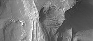 火星勘测轨道飞行器背景相机拍摄的特比陨击坑北侧壁上的岩层。
 -
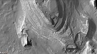 特比陨击坑北侧壁上显示出的很多分层。


据认为由水流形成的河道从四面八方进入盆地[92][93][94][95]。

道谷发源于一座名为哈德里亚卡火山口的大型火山附近,因此,人们认为它容纳了从大量冻土中被炽热岩浆融化出的水[96]。相邻图像中河道左侧的圆形洼地表明,地下水的侵蚀也产生了水[97]。 希腊流域几乎可能是整个北部平原面积的五分之一。在当今火星气候下,希腊盆地中的湖泊会在顶层形成厚厚的冰,最终会因升华而消逝,冰直接从固态变成气体,就像地球上的干冰(固态C二氧化碳)一样[98]。冰川特征(末端冰碛、鼓丘和蛇形丘)可能是在水凝结成冰时所形成[96][99]。希腊盆地中的湖泊可能曾持续了很长一段时间,特别是如有地热源的话,因此,微生物生命可能有时间在那里繁衍[86]。
![希腊盆地区地形,陨坑低于火星标准地形基准面7152米(23000英尺) [100]。](/wiki/File:Hellas_basin_topo.jpg)
![显示了陨坑巨大深度的希腊盆地地图,它是火星上最深的撞击坑,表面气压最高:1155帕 [101] (11.55毫巴、0.17磅/英寸2或0.01个标准大气压)。](/wiki/File:False_color_of_Hellas_Planitia.jpeg)
=盖尔撞击坑

盖尔撞击坑是火星上靠近埃俄利斯区西北部的一座陨石坑,直径154公里(96英里),坑内坐落着一座比西雅图雷尼尔山还高的中央峰-埃俄利斯山(先前曾非正式命名为夏普山,以纪念地质学家罗伯特·夏普)。有确凿的证据表明,盖尔撞击坑中曾拥有过一座大湖[102][103][104]。2012年8月6日,火星科学实验室降落在盖尔撞击坑中埃俄利斯山附近的埃俄利斯沼内[103][104][105][106][107][108][109]。
2012年8月5日,火星科学实验室“好奇号”漫游车降落在盖尔撞击坑内一座层状山丘下。随着任务的展开,美国宇航局公布的发现和结论详细例举出越来越多的证据,表明盖尔曾经有过一座大湖。2012年9月27日,科学家宣布“好奇号”发现了表明火星之水曾“奔腾流动”的古河床证据[110][111][112]。2013年12月9日,美国宇航局报告说,盖尔撞击坑中有一座可能为微生物宜居环境的古淡水湖[113][114]。“好奇号”发现了细粒沉积岩,这代表了一座原本适合化能无机自养型生命的古湖泊。这种液态水环境具有中性pH值、低盐度以及适用于某些微生物的铁和硫,并测量到了生命所需的碳、氢、氧、硫、氮等元素。盖尔撞击坑中的古湖泊可能曾存续了数百到数万年[115]。
“好奇号”在盖尔撞击坑黄刀湾沉积岩(泥岩)中发现了只有在有水情况下才能形成的粘土矿物(三八位层状矿物),该泥岩样本分别被命名为约翰·克莱恩和坎伯兰。据估计,它们形成的时间晚于诺亚纪年代,这意味着那里的水存在的时间可能比以前所想的要更长。
{{Multiple image|direction=vertical|align=right|width=200|image1=PIA17594-MarsCuriosityRover-JohKleinMudstoneDrillHole-20130510.jpg|image2=PIA17599-MarsCuriosityRover-CumberlandRock-Spectra-20121209.jpg|image3=PIA17598-MarsCuriosityRover-Mudstone-ClayMineralStructure-20131209.jpg|caption1=“[[火星岩石列表#2012年-“好奇号”火星车(火星科学实验室)|约翰·克莱因]”泥岩上(1.6厘米(0.63英寸)的钻孔。|caption2=坎伯兰泥岩的光谱分析。|caption3=泥岩中的粘土矿物。|footer=2013年5月,“好奇号”漫游车在火星黄刀湾附近进行的泥岩勘查。}}
盖尔撞击坑中分布着许多冲积扇和三角洲,它们提供了过去湖泊水位的信息。这些地层为:薄饼三角洲、西部三角洲、法拉谷三角洲和和皮斯谷冲积扇[116]。 在2014年12月8日的新闻发布会上,火星科学家详述了“好奇号”探测车的观测结果,表明火星夏普山是由数千万年来堆积在大型湖床上的沉积物所构成。这一发现表明,古代火星的气候可能在该星球上的许多地方形成了长久的湖泊。岩层表明这座巨大的湖泊曾被多次注满和蒸发,证据是许多相互堆叠的三角洲[117][118][119][120][121][122][123]。

盖尔撞击坑被认为是一座封闭型盆地湖泊,因为它只有流入,而没有流出河道。[27]。
粘土及硫酸盐矿物只在有水环境中才能形成,它们也能保存过去生命的印迹。盖尔撞击坑岩石中记录的水历史,为“好奇号”研究火星是否曾是微生物栖息地提供了许多线索。盖尔撞击坑的特别之处是可以同时观察到在不同水环境中形成的粘土和硫酸盐矿物。


霍顿撞击坑
{{Infobox crater data
| titlecolor = #FA8072
| title = 霍顿撞击坑
| image =  | caption = 霍顿撞击坑热辐成像系统白昼图像
| coordinate_title = [[火星#地理|坐标]
| globe = 火星
}}
| caption = 霍顿撞击坑热辐成像系统白昼图像
| coordinate_title = [[火星#地理|坐标]
| globe = 火星
}}
 乌斯钵谷热辐成像系统白昼图像 | |
| 长度 | 366.0 |
|---|---|
| 名称 | 俄罗斯一条干河床 |
霍顿撞击坑是珍珠湾区一座直径40公里的陨石坑,其名称取自美国天文学家、太平洋天文学会创始人爱德华·辛格登·霍顿(Edward Singleton Holden)[124]。与火星上其他一些陨石坑一样,霍顿撞击坑有一条溢出河道—乌斯钵谷与之相通,陨坑内的一些特征,尤其是湖泊沉积物,似乎是由流水所形成[125]。 该陨坑的坑壁上被切刻出道道冲沟,一些冲沟的末端是水流搬运物形成的扇形冲积堆[125][126]。该陨坑引起了科学家们的极大兴趣,因为它清楚地暴露出了一些湖泊沉积物[127]。火星侦察轨道器发现这些地层中含有粘土 [128][125][129][130],粘土只有在有水情况下才能形成。该地区被怀疑曾流淌过大量的水流,并发生在一处比休伦湖更大的水体在冲破坑壁阻挡后所引发的巨流[131][132]。霍顿撞击坑是一座古老的陨坑,里面分布着许多更小的撞击坑,其中许多坑内都填满了淤积物。事实上,霍顿撞击坑中暴露的沉积物超过150米,尤其在陨坑西南部,坑内的中央山脉也被沉积物遮蔽,大部分沉积物可能来自河流和湖泊的堆积[133]。霍顿撞击坑也位于乌斯钵-拉冬-摩拉瓦谷溢流水系中。

霍顿撞击坑地质史
对霍顿撞击坑周边整个区域的研究,使人们了解到塑就该陨坑以及两座不同湖泊的一系列复杂事件[134]。从阿耳古瑞盆地一座大型湖泊中泄出的水流形成了一系列被称作“乌斯钵-拉东-摩拉瓦水系”的大型河流[135][136][137]。当撞击发生并产生出霍顿撞击坑后,该水系被一道几乎1公里高的坑壁阻断。被坑壁拦挡的水流,可能还有地下渗出的水,一起汇聚成了第一座湖[86][138][139],该湖泊幽深而持久,湖中淤积了最底层的沉积岩。由于霍顿坑壁的阻挡,大量的水流被排入乌斯钵谷,加上尼格尔谷的汇入,水流量达到4800米3/秒[140]。当水位涨至某一高度时,蓄水冲破了霍顿撞击坑坑壁,形成第二座200-250米深、寿命较短的湖泊[141]。深度至少50米的水流以密西西比河5-10倍的流速冲入进霍顿撞击坑[142][143][144][145][146],所遗存的阶坡和大岩石(数十米宽)支持了这种高流出率[86][143][147][148][149]。
西埃律西昂平原古湖
有证据表明在埃律西昂西部有一座大型湖泊,然而,一些研究人员认为这种地形可用大熔岩流来解释[86][150]。这座假想湖泊的流域面积超过150公里2,覆盖着断裂的地块和蜿蜒的山脊,看上去就像地球上的大块浮冰[151][152][153]。该区域多边形地形中呈现的图案地面和侵蚀模式支持了含冰物质,因此是一座湖泊。此外,流线型岛屿、瀑布和树枝状河道系统的存在表明,来自湖泊中的水流形成了这种结构[154]。这里的一些地表分布有“无根锥”,一种带有凹坑的土堆。它们可能是熔岩在富冰地表上流动时,熔岩与地下冰一起爆炸所导致。冰融化并变成蒸汽,在爆炸中膨胀,形成圆锥体或圆环。冰岛也发现了类似的特征,当熔岩覆盖被水浸透的基底时[155][156][157]。埃律西昂平原盆地几乎可被描述为一种完美的等位面,因为它在500公里范围内仅倾斜了10米左右,与地球海洋的水平面差不多[158]。这一非常平缓的坡度反驳了熔岩流说[159]。在一些地方已发现流面降低了一半,如果流体是水,则会出现这种情况,但如果是熔岩,则不会降低[152]。据估计,该湖泊的最大深度在31到53米之间[152]。西埃律西昂古湖位于埃律西昂区南部,靠近埃律西昂火山区南部和刻耳柏洛斯堑沟群附近,有人提出,该古湖的水来自刻耳柏洛斯堑沟群中的凹槽。现已提出了数种想法来解释其确切的机制,包括地下水排泄[160][161]和穿过冰冻圈的岩脉[162]。


阿耳古瑞盆地
阿耳古瑞盆地是在希腊撞击7000万年后,发生的又一次巨大撞击中形成的[163]。在火星早期历史中,据推测盆地内就可能有一座湖泊[164]。阿耳古瑞盆地位于阿耳古瑞区内,至少有三条河谷(苏里尤斯谷、泽盖谷和帕拉科帕斯谷)从南部流入到湖中。在阿耳古瑞湖冻结后,冰形成了今天可见的蛇形丘[165][166]。一篇发表在《伊卡洛斯》上由22名研究人员撰写的文章得出结论,形成阿耳古瑞盆地的大撞击可能撞击到了冰盖或厚厚的永久冻土层,所产生的能量融化了冰,形成了一座巨大的湖泊,最后将水输送到北方。该湖泊的容积相当于地球上的地中海,最深处可能需要超过十万年的时间才能结冰,但在撞击热量、地热能和溶解物的帮助下,它可能拥有了数百万年的液态水,生命可能在此阶段发展起来。该区域显示了大量具有流体特征的冰川活动证据,包括冰隙状裂缝、鼓丘、蛇丘、冰斗湖、刃岭、冰斗、角峰、U形谷和台阶地等。由于阿耳古瑞蜿蜒山脊的形状,作者得出结论认为它们是蛇形丘 [167]。
-
 显示阿耳古瑞盆地地理环境的火星轨道器激光高度计地图。
 -
 显示阿耳古瑞平原及其他地区边界的火星轨道器激光高度计地图。
 -

-
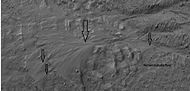 HiWish计划下高分辨率成像科学设备显示的数级冲积扇,这些冲积扇所在位置如上图所示,冲积扇是在水的作用下形成的。
 -
 HiWish计划下高分辨率成像科学设备显示的小型、形态良好的冲积扇。该冲积扇的位置如上图所示,水参与了冲积扇的形成。


里奇陨击坑
里奇陨击坑是科普剌塔斯区一座直径79公里的撞击坑,其名称取自美国天文学家乔治·威利斯·里奇(1864年-1945年)[168],有强力证据表明它曾经是一座湖泊[169][170]。里奇陨击坑曾被建议为火星探测车的着陆点[170],在该陨坑中发现了包括粘土在内的一系列沉积物[169][171],粘土沉积物表明坑中曾存在过一段时间的水,沿陨坑壁和边缘上的河流特征以及冲积物/河流沉积物,支持了过去某个时间存在大量水的观点。
-
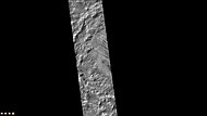 火星勘测轨道飞行器背景摄机拍摄的里奇陨击坑西侧坑壁上的冲积扇,注意:这是前一幅图像的放大版。

耶泽罗撞击坑
 耶泽罗撞击坑及周边区域 | |
| 行星 | 火星 |
|---|---|
| 直径 | 49公里(30.4英里) |
| 命名 | 耶泽罗是斯拉夫语中“湖泊”的意思 |

耶泽罗撞击坑是火星上位于大瑟提斯区北纬18.855度、东经77.519度处的一座陨石坑[172],直径约49.0公里(30.4英里)。该陨坑被认为曾被洪水淹没过,里面分布有一片富含粘土的扇状三角洲沉积物[173]。

耶泽罗撞击坑曾被考虑为火星科学实验室登陆地,也是“毅力”号火星探测车的着陆点[174]。在该陨坑及周边发现了粘土矿物[175][176][177],火星勘测轨道飞行器发现了蒙脱石粘土[178],粘土在有水情况下才形成,所以该地区在古代可能曾经有水,也可能有生命。一些地方的地表开裂成多边形图案,这种形状通常在粘土变干时所形成[172]。
2015年3月,研究人员在发表的一篇论文中描述了杰泽罗陨石坑中如何存在一座火星古湖泊系统的看法。这项研究提出了这样一种观点,即该陨坑至少两次被水注满[175][179][180][181]。在陨石坑北侧和西侧有两条供流水道,这两条水道在登陆点附近都有类似三角洲的沉积物,沉积物被水挟带并沉积在湖中[182],图片显示了这些分层和弯流[183][184]。
火星2020任务的主要目标是寻找古代生命的迹象,希望后续的任务可从被确认可能含有生命遗骸的地点取样返还。为了能安全降落,需要一片12英里(20公里)宽、平坦和缓的圆形区域。地质学家希望检查曾经积水的地方[185],对沉积层层进行勘查。
埃里达尼亚湖
[艾瑞达尼亚湖|埃里达尼亚湖]] 是一座理论上的古湖泊,面积约110万公里2[186][187][188][189],其最大深度为2400米,容积562000公里3,比地球上最大的内陆海里海还要大,较火星上其他所有湖泊的水量加起来还要多。埃里达尼亚湖的蓄水量是北美五大湖的9倍多[190][191][192]。推测该湖湖面位于环湖河谷的较高处,因为所有河谷都终止于同一海拨高度,表明它们流入进同一座湖中[193][194][195]。
-
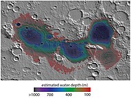 显示了埃里达尼亚湖不同地区估测水深的地图,地图宽约530英里。
 -
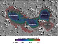 标注出的埃里达尼亚湖周边特征


三座盆地组成了阿里阿德内斯湖(以东经175度、南纬35度为中心)、亚特兰蒂斯湖(东经182度,南纬32度为中心)和戈尔贡湖(东经192度,南纬37度为中心)[196][197][198],它们位于马丁谷溢出河道的源头,并延伸至厄律达尼亚区和法厄同区[199][200]。随着厄里达尼亚湖在诺亚纪晚期的干涸,它分成了一系列较小的湖泊[86][201][202][203]。在这座假设的湖泊边界内发现了需要水才能形成的粘土。利用紧凑型火星侦察成像光谱仪的高光谱数据,它们被鉴定为含镁/铁的页硅酸盐和富铝页硅酸盐[204]。在2016年发表的,使用火星快车号光学与红外矿物光谱仪和紧凑型火星侦察成像光谱仪进一步的研究发现,富铝粘土层之上有一层覆盖层(可能是铝蒙脱石和/或高岭土)。这层之下是含铁的粘土,称为绿脱石(nontronite smectite),然后是一层沸石或水合硫酸盐,还发现了少量明矾石和黄钾铁矾矿床,粘土矿物为保存过去火星生命遗迹提供了有利条件[197]。
后来用紧凑型火星侦察成像光谱仪进行的研究发现了厚度超过400米的厚矿床,其中含有皂石、滑石皂石、富铁云母(例如海绿石-绿脱石)、铁和镁蛇纹石、镁铁钙碳酸盐和可能的硫化铁。硫化铁可能是在火山加热的深水中形成的,这种被归类为热液作用的过程可能是生命起源的地方[205]。皂石、滑石皂石、绿脱石、海绿石和蛇纹石在地球海底都很常见[206][207][208]。地球上生命最早证据出现在海底沉积物中,这些沉积物与在埃里达尼亚盆地发现的沉积物相似[209],所以,来自埃里达尼亚湖的物质样本可让我们深入了解早期地球的环境。在存在湖滨线的地方发现了氯化物沉积物,它们是随着湖水的蒸发而沉积下来的。这些氯化物沉积物被认为很薄(不到30米),因为一些陨石坑的喷射物中并没有显示出这种化学物质。陨石坑的喷出物含有地表下物质,因此,如果氯化物沉积很厚,它们就会出现在喷出物中[210]。
-
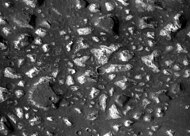 来自埃里达尼亚湖底深水盆地的沉积物。地表上存在的桌山因受到深水/冰盖的保护而免受强烈侵蚀。紧凑型火星侦察成像光谱仪的测量表明,矿物可能来自湖底热液矿床,生命有可能起源于这片湖泊。
 -
 图中显示了火山活动如何导致埃里达尼亚湖底矿物的堆积,蒸发的氯化物沿湖岸线沉积。


2018年,在德克萨斯州举行的行星科学会议上,发表的一篇论文提出,埃里达尼亚深湖富含能量和化学营养的环境可孕育了古代生命,地球上生命的最早证据与这种深水环境相类似[211]。
哥伦布撞击坑
 热辐射成像系统拍摄的哥伦布撞击坑白昼图像 | |
| 行星 | 火星 |
|---|---|
| 直径 | 119公里 |
| 命名 | 克里斯托弗·哥伦布,意大利探险家(1451年–1506年) |
| 维基共享资源上的相关多媒体资源:火星湖泊 |
哥伦布撞击坑是门农尼亚区一座直径119公里的陨石坑,以意大利探险家克里斯托弗·哥伦布(1451年-1506年)的名字所命名[124][212]。利用轨道近红外光谱仪分析矿物吸收光波长的研究,发现了哥伦布撞击坑中存在粘土层和硫酸盐层的证据,其状况就如一座缓慢蒸发的大湖一样[86][213][214][215]。此外,由于一些地层中含有石膏,一种在相对中性淡水中形成的硫酸盐,因此,生命曾可能会在该陨坑中形成[216]。火星勘测轨道飞行器上的紧凑型火星侦察成像光谱仪还发现了高岭石,包括明矾石和可能的黄钾铁矾等水合硫酸盐[128]。进一步的研究得出结论,石膏、多水和一水镁/铁硫酸盐较为普遍,并且发现了少量蒙脱石、铁/镁页硅酸盐和结晶氧化铁或氢氧化物沉积物。热辐射光谱表明,一些矿物的含量在百分之几十的范围内,这些矿物表明陨石坑中存在过水[214][217]。科学家们对在火星上发现硫酸盐和粘土等水合矿物感到兴奋,因为它们通常是在有水的情况下形成的[218],含有粘土和/或其他水合矿物的地方是寻找生命证据的合适地点[219]。富铝粘土层上方发现硫酸盐矿物,意味着在粘土形成的早期,水更中性,可能更容易发育,硫酸盐通常是在偏酸性水环境中形成的[220]。
-
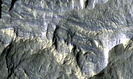 高分辨率成像科学设备显示的哥伦布撞击坑岩层,这张伪色图大约800英尺宽,有些岩层含有水合矿物。

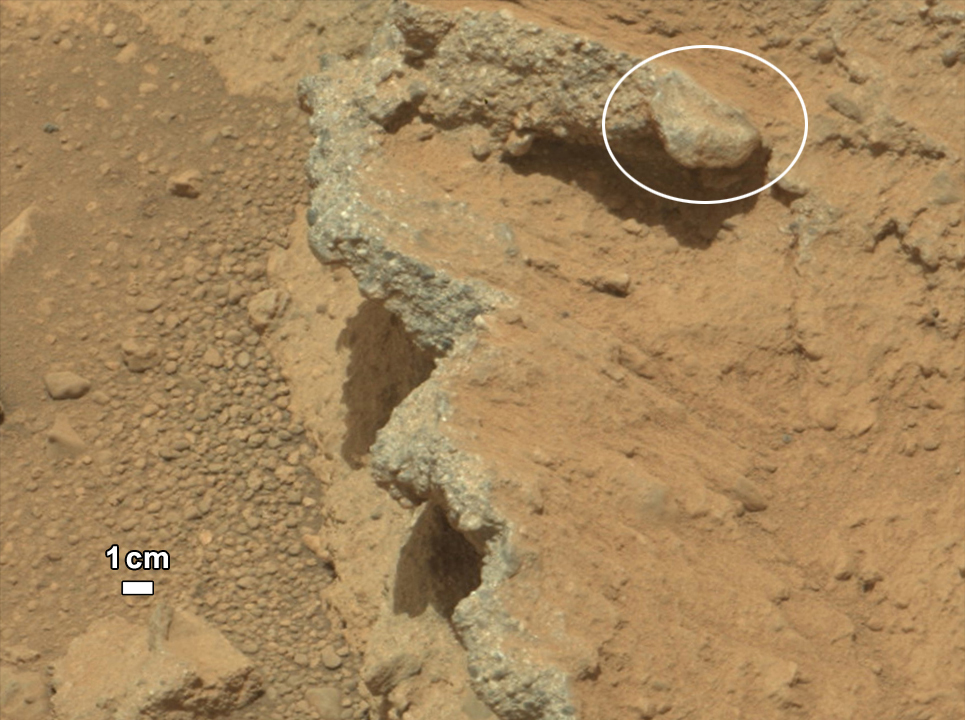
纳武阿峡谷群
希腊盆地东北部的纳武阿谷(Navua Valles)水道可能也曾是一座大型封冻湖的所在地[198]。
南极冰盖冰下湖

2018年,宣布在火星南极冰盖下发现了一座冰下湖,该湖由火星快车号轨道器探测到,长20公里(10英里),位于约1.5公里(1英里)厚的冰川覆盖之下,水温估计为摄氏−68度(华氏-90度),为极咸的卤水[221][222][223]。
2020年9月,科学家们证实在火星南极地区冰层下存在几座大型咸水湖,根据其中一位研究人员的说法,“我们确认了相同的水体[正如先前初步检测中所建议的那样],但我们还在主水体周围发现了另外三处水体……这是一个复杂的系统”[224][225]。
另请查看
参考文献
- ^ Mariner 4: First Spacecraft to Mars. space.com. [4 July 2015].
- ^ Blast from the past: Mariner 4's images of Mars | The Planetary Society. planetary.org. [4 July 2015].
- ^ Snyder, C., V. Moroz. 1992. Spacecraft exploration of Mars. In Kieffer, H., B. Jakosky, C. Snyder, M. Matthews, (eds). 1992. Mars. University of Arizona Press. Tucson.
- ^ What is the evidence for water on Mars?. astronomycafe.net. [4 July 2015].
- ^ Madeleine, J. et al. 2007. Mars: A proposed climatic scenario for northern mid-latitude glaciation. Lunar Planet. Sci. 38. Abstract 1778.
- ^ Madeleine, J. et al. 2009. Amazonian northern mid-latitude glaciation on Mars: A proposed climate scenario. Icarus: 203. 300–405.
- ^ Mischna, M.; et al. On the orbital forcing of Martian water and CO2 cycles: A general circulation model study with simplified volatile schemes. J. Geophys. Res. 2003, 108 (E6): 5062. doi:10.1029/2003je002051
 .
.
- ^ Newsom, H. 2010. Heated Lakes on Mars. In Cabrol, N. and E. Grin (eds.). 2010. Lakes on Mars. Elsevier. NY.
- ^ Fairén, A. G.; et al. Stability against freezing of aqueous solutions on early Mars. Nature. 2009, 459 (7245): 401–404. Bibcode:2009Natur.459..401F. PMID 19458717. S2CID 205216655. doi:10.1038/nature07978.
- ^ Abramov, O.; Kring, D. Impact-induced hydrothermal activity on early Mars. Journal of Geophysical Research. 2005, 110 (E12): E12S09. Bibcode:2005JGRE..11012S09A. S2CID 20787765. doi:10.1029/2005je002453 .
- ^ Newsom, H. Hydrothermal alteration of impact melt sheets with implications for Mars. Icarus. 1980, 44 (1): 207–216. Bibcode:1980Icar...44..207N. doi:10.1016/0019-1035(80)90066-4.
- ^ Newsom, H.; et al. Impact crater lakes on Mars. J. Geophys. Res. 1996, 101 (E6): 14951–9144955. Bibcode:1996JGR...10114951N. doi:10.1029/96je01139.
- ^ McKay, C.; Davis, W. Duration of liquid water habitats on early Mars. Icarus. 1991, 90 (2): 214–221. Bibcode:1991Icar...90..214M. PMID 11538097. doi:10.1016/0019-1035(91)90102-y.
- ^ Bibring, J.; et al. Global mineralogical and aqueous history derived from OMEGA observations. Science. 2006, 312 (5772): 400–404. Bibcode:2006Sci...312..400B. PMID 16627738. doi:10.1126/science.1122659 .
- ^ Murchie, S., et al. 2008. First results from the Compact Reconnaissance Imaging Spectrometer for Mars (CRISM), LPSC XXXIX abstract 1472.
- ^ Zolotov, M., M. Mironenko. 2008. Formation and fate of phyllosilicates on the surface of Mars: Geochemical modeling of aqueous weathering. LPSC XXXIX, Abstract 3365.
- ^ Carr, M., J. Head. In Cabrol, N. and E. Grin (eds.). 2010. Lakes on Mars. Elsevier. NY
- ^ Gendrin, A.; et al. Sulfates in Martian Layered Terrains: The OMEGA/Mars express view. Science. 2005, 307 (5715): 1587–1591. PMID 15718429. S2CID 35093405. doi:10.1126/science.1109087.
- ^ Evidence of Vast Quantities of Water Ice on Mars. universetoday.com. 2002-05-28 [4 July 2015].
- ^ Lunar & Planetary Lab at The University of Arizona. [4 July 2015]. (原始内容存档于2008-10-13).
- ^ Ground ice on Mars is patchy and variable | Mars Odyssey Mission THEMIS. themis.asu.edu. [4 July 2015].
- ^ Ice Under the Lander? | Phoenix on Mars. phoenixonmars.wordpress.com. 2008-05-31 [4 July 2015].
- ^ Confirmation of Water on Mars. Phoenix Mars Lander. NASA. 20 June 2008. (原始内容存档于1 July 2008).
- ^ De Hon, R. Martian lake basins and lacustrine plains. Earth Moon Planets. 1992, 56 (2): 95–122. S2CID 120002712. doi:10.1007/bf00056352.
- ^ 25.0 25.1 Cabrol, N.; Grin, E. Distribution, classification, and ages of martian impact crater lakes. Icarus. 1999, 142: 160–172. doi:10.1006/icar.1999.6191.
- ^ Cabrol, N.; Grin, E. The evolution of lacustrine environments on Mars: Is Mars only hydrologically dormant. Icarus. 2001, 149 (2): 291–328. doi:10.1006/icar.2000.6530.
- ^ 27.0 27.1 Goudge, T.; Aureli, K.; Head, J.; Fassett, C.; Mustard, J. Classification and analysis of candidate impact crater-hosted closed-basin lakes on Mars. Icarus. 2015, 260: 346–367. doi:10.1016/j.icarus.2015.07.026.
- ^ Fassett, C. J. Head. Valley network-fed, open-basin lakes on Mars: Distribution and implications for Noachian surface and subsurface hydrology. Icarus. 2008, 198 (1): 37–56. Bibcode:2008Icar..198...37F. doi:10.1016/j.icarus.2008.06.016.
- ^ Zhao, J., et al. 2018. PALEOLAKES IN THE NORTHWEST HELLAS REGION: IMPLICATIONS FOR PALEO-CLIMATE AND REGIONAL GEOLOGIC HISTORY. 49th Lunar and Planetary Science Conference 2018 (LPI Contrib. No. 2083).
- ^ Salese F. et al. (2016) JGR, 120, 2555–2570.
- ^ Davis, J., et al. 2018. INVERTED PALAEOLAKES IN ARABIA TERRA, MARS: EVIDENCE FOR FLUCTUATING EROSION AND DEPOSTION IN THE NOACHIAN. 49th Lunar and Planetary Science Conference 2018 (LPI Contrib. No. 2083). 1902
- ^ Boatwright, B., et al. 2021. INVERTED FLUVIAL CHANNELS IN TERRA SABAEA, MARS: GEOMORPHIC EVIDENCE FOR PROGLACIAL LAKES AND WIDESPREAD HIGHLANDS GLACIATION IN THE LATE NOACHIAN. 52nd Lunar and Planetary Science Conference 2021 (LPI Contrib. No. 2548). 1641.pdf
- ^ https://www.brown.edu/news/2021-03-30/crater-lake
- ^ Hargitai, Henrik I.; Gulick, Virginia C.; Glines, Natalie H. Paleolakes of Northeast Hellas: Precipitation, Groundwater-Fed, and Fluvial Lakes in the Navua–Hadriacus–Ausonia Region, Mars. Astrobiology. 2018, 18 (11): 1435–1459. Bibcode:2018AsBio..18.1435H. PMID 30289279. doi:10.1089/ast.2018.1816.
- ^ Groundwater and Precipitation Provided Water to Form Lakes along the Northern Rim of Hellas Basin throughout Mars's History | SETI Institute.
- ^ Hargitai, H.; et al. Groundwater-Fed, and Fluvial Lakes in the Navua–Hadriacus–Ausonia Region, Mars. Astrobiology. 2018, 18: 1435–1459. Bibcode:2018AsBio..18.1435H. PMID 30289279. doi:10.1089/ast.2018.1816.
- ^ Irwin, R.; et al. An intense terminal epoch of widespread fluvial activity on early Mars. 2. Increased runoff and paleolake development. J. Geophys. Res. 2005, 110 (E12): E12S15. Bibcode:2005JGRE..11012S15I. doi:10.1029/2005JE002460 .
- ^ Fassett, C.; Head, J. Valley network-fed, open-basin lakes on Mars: Distribution and implications for Noachian surface and subsurface hydrology. Icarus. 2008, 198 (1): 37–56. Bibcode:2008Icar..198...37F. CiteSeerX 10.1.1.455.713 . doi:10.1016/j.icarus.2008.06.016.
- ^ Grant, J. T. Parker. Drainage evolution in the Margaritifer Sinus region, Mars. J. Geophys. Res. 2002, 107 (E9): 5066. Bibcode:2002JGRE..107.5066G. doi:10.1029/2001JE001678 .
- ^ Head, J., S. Pratt. 2001. Closed chaos basins on Mars: Evidence for regional groundwater drawdown and collapse. Lunar Planet. Sci. XXXII. Abstract 1774.
- ^ Irwin, R.; et al. A large paleolake basin at the head of Ma'adim Vallis, Mars. Science. 2002, 296 (5576): 2209–2212. Bibcode:2002Sci...296.2209R. PMID 12077414. S2CID 23390665. doi:10.1126/science.1071143.
- ^ Irwin, R.; et al. Geomorphology of Ma'adim Vallis, Mars, and associated paleolake basins. J. Geophys. Res. 2004, 109 (E12): E12009. Bibcode:2004JGRE..10912009I. doi:10.1029/2004JE002287.
- ^ ESA Staff. First Evidence of "Planet-Wide Groundwater System" on Mars Found. European Space Agency. 28 February 2019 [28 February 2019].
- ^ Houser, Kristin. First Evidence of "Planet-Wide Groundwater System" on Mars Found. Futurism.com. 28 February 2019 [28 February 2019].
- ^ 45.0 45.1 45.2 Salese, Francesco; Pondrelli, Monica; Neeseman, Alicia; Schmidt, Gene; Ori, Gian Gabriele. Geological Evidence of Planet‐Wide Groundwater System on Mars. Journal of Geophysical Research: Planets. 2019, 124 (2): 374–395. Bibcode:2019JGRE..124..374S. PMC 6472477 . PMID 31007995. doi:10.1029/2018JE005802.
- ^ Mars: Planet‐Wide Groundwater System – New Geological Evidence. 19 February 2019.
- ^ http://astrobiology.com/2019/02/first-evidence-of-a-planet-wide-groundwater-system-on-mars.html
- ^ 48.0 48.1 Brandenburg, John E., The Paleo-Ocean of Mars, Meca Symposium on Mars: Evolution of Its Climate and Atmosphere, 1987: 20–22, Bibcode:1987meca.symp...20B
- ^ 49.0 49.1 49.2 Cabrol, N. and E. Grin (eds.). 2010. Lakes on Mars. Elsevier. NY
- ^ Clifford, S. M.; Parker, T. J. The Evolution of the Martian Hydrosphere: Implications for the Fate of a Primordial Ocean and the Current State of the Northern Plains. Icarus. 2001, 154 (1): 40–79. Bibcode:2001Icar..154...40C. doi:10.1006/icar.2001.6671.
- ^ Baker, V. R.; Strom, R. G.; Gulick, V. C.; Kargel, J. S.; Komatsu, G.; Kale, V. S. Ancient oceans, ice sheets and the hydrological cycle on Mars. Nature. 1991, 352 (6336): 589–594. Bibcode:1991Natur.352..589B. S2CID 4321529. doi:10.1038/352589a0.
- ^ Mars: The planet that lost an ocean's worth of water. ScienceDaily. [4 July 2015]. (原始内容存档于8 March 2015).
- ^ Nasa finds evidence of a vast ancient ocean on Mars. msn.com. [4 July 2015].
- ^ Villanueva, G.; Mumma, M.; Novak, R.; Käufl, H.; Hartogh, P.; Encrenaz, T.; Tokunaga, A.; Khayat, A.; Smith, M. Strong water isotopic anomalies in the martian atmosphere: Probing current and ancient reservoirs. Science. 2015, 348 (6231): 218–221. Bibcode:2015Sci...348..218V. PMID 25745065. S2CID 206633960. doi:10.1126/science.aaa3630.
- ^ 55.0 55.1 Read, Peter L. and S. R. Lewis, "The Martian Climate Revisited: Atmosphere and Environment of a Desert Planet", Praxis, Chichester, UK, 2004.
- ^ Staff. Mars Probably Once Had A Huge Ocean. University of California – Berkeley (Science Daily). 13 June 2007 [19 February 2014].
- ^ Staff. Mars Ocean Hypothesis Hits the Shore. Astrobiology Magazine. 26 January 2001 [19 February 2004].
- ^ Malin, M. C.; Edgett, K. S. Oceans or Seas in the Martian Northern Lowlands: High Resolution Imaging Tests of Proposed Coastlines. Geophys. Res. Letters. 1999, 26 (19): 3049–3052. doi:10.1029/1999gl002342 .
- ^ Staff. Martian North Once Covered by Ocean. Astrobiology Magazine. 26 November 2009 [19 February 2014].
- ^ Luo, W.; Stepinski, T. Computer‐generated global map of valley networks on Mars. Journal of Geophysical Research: Planets. 2009, 114 (E11): E11. Bibcode:2009JGRE..11411010L. doi:10.1029/2009JE003357. hdl:10843/13357 .
- ^ Luo, Wei; Stepinski, T. F. Computer-generated global map of valley networks on Mars. Journal of Geophysical Research. 2009, 114 (E11): E11010. Bibcode:2009JGRE..11411010L. doi:10.1029/2009JE003357. hdl:10843/13357 .
- ^ Staff. New Map Bolsters Case for Ancient Ocean on Mars. Space.com. 23 November 2009 [19 February 2014].
- ^ DiAchille, G; Hynek, B. Ancient ocean on Mars supported by global distribution of deltas and valleys. Nat. Geosci. 2010, 3 (7): 459–463. Bibcode:2010NatGe...3..459D. doi:10.1038/ngeo891.
- ^ DiBiasse; Limaye, A.; Scheingross, J.; Fischer, W.; Lamb, M. Deltic deposits at Aeolis Dorsa: Sedimentary evidence for a standing body of water on the northern plains of Mars (PDF). Journal of Geophysical Research: Planets. 2013, 118 (6): 1285–1302. Bibcode:2013JGRE..118.1285D. doi:10.1002/jgre.20100 .
- ^ Mouginot, J.; Pommerol, A.; Beck, P.; Kofman, W.; Clifford, S. Dielectric map of the Martian northern hemisphere and the nature of plain filling materials (PDF). Geophysical Research Letters. 2012, 39 (2): L02202. Bibcode:2012GeoRL..39.2202M. doi:10.1029/2011GL050286 .
- ^ Villanueva, G. L.; Mumma, M. J.; Novak, R. E.; Käufl, H. U.; Hartogh, P.; Encrenaz, T.; Tokunaga, A.; Khayat, A.; Smith, M. D. Strong water isotopic anomalies in the martian atmosphere: Probing current and ancient reservoirs. Science. 2015, 348 (6231): 218–221. Bibcode:2015Sci...348..218V. PMID 25745065. S2CID 206633960. doi:10.1126/science.aaa3630.
- ^ Webster, C.R.; et al. Isotope Ratios of H, C, and O in CO2 and H2O of the Martian Atmosphere (PDF). Science. 2013, 341 (6143): 260–263. Bibcode:2013Sci...341..260W. PMID 23869013. S2CID 206548962. doi:10.1126/science.1237961.
- ^ McCauley, J. 1978. Geologic map of the Coprates quadrangle of Mars. U.S. Geol. Misc. Inv. Map I-897
- ^ Nedell, S.; et al. Origin and evolution of the layered deposits in the Valles Marineris, Mars. Icarus. 1987, 70 (3): 409–441. Bibcode:1987Icar...70..409N. doi:10.1016/0019-1035(87)90086-8.
- ^ Weitz, C. and T. Parker. 2000. New evidence that the Valles Marineris interior deposits formed in standing bodies of water. LPSC XXXI. Abstract 1693
- ^ Cabrol, N. and E. Grin (Eds.). 2010. Lakes on Mars. Elsevier. NY
- ^ Okubo, C. 2015. HIGH-RESOLUTION STRUCTURAL AND GEOLOGIC MAPPING IN CANDOR CHASMA. 46th Lunar and Planetary Science Conference. 1210.pdf
- ^ Bath Salts in Candor Chasma? | Mars Odyssey Mission THEMIS. Themis.asu.edu. [18 August 2012].
- ^ Christensen, P.; et al. Global mapping of Martian hematite mineral deposits: Remnants of water-driven processes on early Mars. J. Geophys. Res. 2001, 106 (E10): 23873–23885. Bibcode:2001JGR...10623873C. doi:10.1029/2000je001415 .
- ^ Weitz, C.; et al. Gray hematite distribution and formation in Ophir and Candor Chasmata. J. Geophys. Res. 2008, 113 (E2): E02016. Bibcode:2008JGRE..113.2016W. doi:10.1029/2007je002930.
- ^ Cattermole, Peter John. Mars: the mystery unfolds
 . Oxford University Press. 2001: 105. ISBN 978-0-19-521726-1.
- ^ HiRISE | Eroding Layers in Melas Chasma (PSP_004054_1675). hirise.lpl.arizona.edu. [4 July 2015].
- ^ HiRISE | MSL Landing Site in Melas Chasma (PSP_002828_1700). hirise.lpl.arizona.edu. [4 July 2015].
- ^ Williams, R.; Weitz, C. Reconstructing the aqueous history within the southwestern Melas basin, Mars: Clues from stratigraphic and morphometric analyses of fans. Icarus. 2014, 242: 19–37. doi:10.1016/j.icarus.2014.06.030.
- ^ Davis, J., P. Grindrod, R. Williams, S. Gupta, M. Balme. 2015. STRATIGRAPHIC EVIDENCE OF EPISODIC FLUVIAL ACTIVITY IN THE SOUTH MELAS CHASMA BASIN, VALLES MARINERIS, MARS. 46th Lunar and Planetary Science Conference. 1932.pdf
- ^ Quantin, et al. 2005.
- ^ Metx, et al. 2009.
- ^ Harrison, K., M. Chapman. 2010. Episodic ponding and outburst flooding associated with chaotic terrains in Valles Marineris In Cabrol, N. and E. Grin (eds.). 2010. Lakes on Mars. Elsevier. NY.
- ^ Harrison, K.; Chapman, M. Evidence for ponding and catastrophic floods in central Valles Marineris, Mars. Icarus. 2008, 198 (2): 351–364. doi:10.1016/j.icarus.2008.08.003.
- ^ Martian Weather Observation 互联网档案馆的存檔,存档日期31 May 2008. One Mars Global Surveyor radio science experiment measured 11.50 mbar at 34.4° S 59.6° E −7152 meters.
- ^ 86.0 86.1 86.2 86.3 86.4 86.5 86.6 86.7 Cabrol, N. and E. Grin (eds.). 2010. Lakes on Mars. Elsevier. NY.
- ^ Voelker, M., et al. 2016. DISTRIBUTION AND EVOLUTION OF LACUSTRINE AND FLUVIAL FEATURES IN HELLAS PLANITIA, MARS, BASED ON PRELIMINARY RESULTS OF GRID-MAPPING. 47th Lunar and Planetary Science Conference (2016) 1228.pdf.
- ^ Crown, D.; et al. Styles and timing of volatile-driven activity in the eastern Hellas region of Mars. J. Geophys. Res. 2005, 110 (E12): E12S22. Bibcode:2005JGRE..11012S22C. doi:10.1029/2005JE002496 . hdl:2060/20050167199.
- ^ Moore, J.; Wilhelms, D. Hellas as a possible site of ancient ice-covered lakes on Mars. Icarus. 2001, 154 (2): 258–276. Bibcode:2001Icar..154..258M. doi:10.1006/icar.2001.6736. hdl:2060/20020050249 .
- ^ Ansan, V. et al. 2005. Analysis of layered deposits in Terby crater Hellas region, Mars using multiple datasets MOC, THEMIS, and OMEGA/MEX date. Lunar Planet. Sci., XXXVI (CD-ROM). Abstract 1324.
- ^ Wilson, S., et al. 2010. Evidence for ancient lakes in the Hellas region. In Cabrol, N. and E. Grin (eds.). 2010. Lakes on Mars. Elsevier. NY.
- ^ Carr, M.; Chung, F. Martian drainage densities. J. Geophys. Res. 1997, 102 (E4): 9145–9152. Bibcode:1997JGR...102.9145C. doi:10.1029/97je00113 .
- ^ Greeley, R., J. Guest. 1987. Geologic map of the eastern equatorial region of Mars. U.S. Geological Survey Miscellaneous Investigations Series I-1802-B, scale 1:15,000,000
- ^ Leonard, G., K. Tanaka. 2001. Geologic map of the Hellas region of Mars, U.S. Geological Survey Miscellaneous Investigations Series I-2694, scale 1:5,000,000
- ^ Tanaka, K., G. Leonard. 1995. Geology and landscape of the Hellas region of Mars, J. Geophys. Res. 100 (E3), 5407_5432
- ^ 96.0 96.1 Carr, Michael H. The Surface of Mars. Cambridge University Press. 2006: [页码请求]. ISBN 978-0-521-87201-0.
- ^ Dao Vallis | Mars Odyssey Mission THEMIS. themis.asu.edu. [4 July 2015].
- ^ Moore, J; Wilhelms, Don E. Hellas as a possible site of ancient ice-covered lakes on Mars. Icarus. 2001, 154 (2): 258–276. Bibcode:2001Icar..154..258M. doi:10.1006/icar.2001.6736. hdl:2060/20020050249 .
- ^ Kargel, J.; Strom, R. Terrestrial glacial eskers: analogs for martian sinuous ridges (PDF). LPSC. 1991, XXII: 683–684. Bibcode:1991LPI....22..683K.
- ^ Ice Sculptures Fill The Deepest Parts of Mars. universetoday.com. 2012-04-03 [12 July 2015].
- ^ Mega-scale civil engineering on Mars. forum.nasaspaceflight.com. [12 July 2015].
- ^ Staff. Wet Paleoclimate of Mars Revealed by Ancient Lakes at Gale Crater. Astrobiology web. October 8, 2015 [October 9, 2015].
- ^ 103.0 103.1 Clavin, Whitney. NASA's Curiosity Rover Team Confirms Ancient Lakes on Mars. NASA. October 8, 2015 [October 9, 2015].
- ^ 104.0 104.1 Grotzinger, J.P.; et al. Deposition, exhumation, and paleoclimate of an ancient lake deposit, Gale crater, Mars. Science. October 9, 2015, 350 (6257): aac7575. Bibcode:2015Sci...350.7575G. PMID 26450214. S2CID 586848. doi:10.1126/science.aac7575.
- ^ NASA Staff. Curiosity's Quad – IMAGE. NASA. 10 August 2012 [11 August 2012].
- ^ Agle, D. C. 'Mount Sharp' On Mars Links Geology's Past and Future. NASA. 28 March 2012 [31 March 2012].
- ^ Staff. NASA's New Mars Rover Will Explore Towering 'Mount Sharp'. Space.com. 29 March 2012 [30 March 2012].
- ^ Archived copy. [2009-02-15]. (原始内容存档于25 February 2009). 已忽略未知参数
|df=(帮助) - ^ http://www.space.com/missionlaunches/mars-science-laboratory-curiosity-landing-sites-100615.htm[永久失效連結]
- ^ 110.0 110.1 Brown, Dwayne; Cole, Steve; Webster, Guy; Agle, D.C. NASA Rover Finds Old Streambed On Martian Surface. NASA. 27 September 2012 [28 September 2012].
- ^ 111.0 111.1 NASA. NASA's Curiosity Rover Finds Old Streambed on Mars – video (51:40). NASAtelevision. 27 September 2012 [28 September 2012].
- ^ 112.0 112.1 Chang, Alicia. Mars rover Curiosity finds signs of ancient stream. Associated Press. 27 September 2012 [27 September 2012].
- ^ Chang, Kenneth. On Mars, an Ancient Lake and Perhaps Life. New York Times. 9 December 2013 [9 December 2013].
- ^ Various. Science – Special Collection – Curiosity Rover on Mars. Science. 9 December 2013 [9 December 2013].
- ^ Grotzinger, J. P.; Sumner, D. Y.; Kah, L. C.; Stack, K.; Gupta, S.; Edgar, L.; Rubin, D.; Lewis, K.; Schieber, J.; Mangold, N.; Milliken, R.; Conrad, P. G.; Desmarais, D.; Farmer, J.; Siebach, K.; Calef, F.; Hurowitz, J.; McLennan, S. M.; Ming, D.; Vaniman, D.; Crisp, J.; Vasavada, A.; Edgett, K. S.; Malin, M.; Blake, D.; Gellert, R.; Mahaffy, P.; Wiens, R. C.; Maurice, S.; et al. A Habitable Fluvio-Lacustrine Environment at Yellowknife Bay, Gale Crater, Mars. Science. 2014, 343 (6169): 1242777. Bibcode:2014Sci...343A.386G. CiteSeerX 10.1.1.455.3973 . PMID 24324272. S2CID 52836398. doi:10.1126/science.1242777.
- ^ Dietrich, W., M. Palucis, T. Parker, D. Rubin, K.Lewis, D. Sumner, R. Williams. 2014. Clues to the relative timing of lakes in Gale Crater. Eighth International Conference on Mars (2014) 1178.pdf.
- ^ Brown, Dwayne; Webster, Guy. Release 14-326 – NASA's Curiosity Rover Finds Clues to How Water Helped Shape Martian Landscape. NASA. 8 December 2014 [8 December 2014].
- ^ Kaufmann, Marc. (Stronger) Signs of Life on Mars. New York Times. 8 December 2014 [8 December 2014].
- ^ NASA's Curiosity rover finds clues to how water helped shape Martian landscape – ScienceDaily. [4 July 2015]. (原始内容存档于2014-12-13).
- ^ JPL | Videos | The Making of Mount Sharp. jpl.nasa.gov. [4 July 2015].
- ^ JPL | News | NASA's Curiosity Rover Finds Clues to How Water Helped Shape Martian Landscape. jpl.nasa.gov. [4 July 2015].
- ^ Williams, R. M. E.; Grotzinger, J. P.; Dietrich, W. E.; Gupta, S.; Sumner, D. Y.; Wiens, R. C.; Mangold, N.; Malin, M. C.; Edgett, K. S.; Maurice, S.; Forni; Gasnault, O.; Ollila, A.; Newsom, H. E.; Dromart, G.; Palucis, M. C.; Yingst, R. A.; Anderson, R. B.; Herkenhoff, K. E.; Le Mouelic, S.; Goetz, W.; Madsen, M. B.; Koefoed, A.; Jensen, J. K.; Bridges, J. C.; Schwenzer, S. P.; Lewis, K. W.; Stack, K. M.; Rubin, D.; et al. Martian fluvial conglomerates at Gale Crater. Science. 2013, 340 (6136): 1068–1072 [4 July 2015]. Bibcode:2013Sci...340.1068W. PMID 23723230. S2CID 206548731. doi:10.1126/science.1237317. 已忽略未知参数
|first 11=(帮助) - ^ Williams, R.; et al. Martian fluvial conglomerates at Gale Crater. Science. 2013, 340 (6136): 1068–1072. Bibcode:2013Sci...340.1068W. PMID 23723230. S2CID 206548731. doi:10.1126/science.1237317.
- ^ 124.0 124.1 Google Mars. [4 July 2015].
- ^ 125.0 125.1 125.2 The 4th MSL Landing Site Workshop: Day 2 – Holden Crater – Martian Chronicles – AGU Blogosphere. blogs.agu.org. 2010-09-29 [4 July 2015].
- ^ Moore, J. A. Howard. Large alluvial fans on Mars. Journal of Geophysical Research. 2005, 110 (E4): E04005. Bibcode:2005JGRE..110.4005M. doi:10.1029/2004je002352 .
- ^ Holden Crater: Where Waters Ran | Mars Odyssey Mission THEMIS. themis.asu.edu. [12 July 2015].
- ^ 128.0 128.1 引证错误:没有为名为
Murchie, S. 2009的参考文献提供内容 - ^ Grotzinger, J. and R. Milliken (eds.) 2012. Sedimentary Geology of Mars. SEPM
- ^ HiRISE | Proposed MSL Landing Site in Holden Crater (PSP_008193_1535). hirise.lpl.arizona.edu. [12 July 2015].
- ^ Grant, J.; et al. A lake in Uzboi Vallis and implications for late Noachian-Early Hesperian climate on Mars. Icarus. 2010, 212: 110–122. doi:10.1016/j.icarus.2010.11.024.
- ^ HiRISE | Megabreccia at Holden Crater (PSP_003077_1530). hirise.lpl.arizona.edu. [4 July 2015].
- ^ Grant, J., R. Irwin, S. Wilson. 2010. Aqueous depositional settings in Holden crater, Mars. In Cabrol, N. and E. Grin (eds.). 2010. Lakes on Mars. Elsevier. NY
- ^ Grant, J. 1987. The geomorphic evolution of Eastern Margaritifer Sinus, Mars. Adv. Planet. Geol. NASA Tech memo. 89889871, 1–268.
- ^ Baker, V. 1982. The Channels of Mars. University of Texas Press, Austin, TX.
- ^ Philillips, R.; et al. Ancient geodynamics and global-scale hydrology on Mars. Science. 2001, 291 (5513): 2587–2591. PMID 11283367. S2CID 36779757. doi:10.1126/science.1058701.
- ^ Saunders, S. 1979. Geologic map of the Margaritifer Sinus quadrangle of Mars, U.S. Geol. Surv. Misc. Invest. Ser. Map I-1144, scale 1:5M.
- ^ Malin, M.; Edgett, K. Evidence for recent groundwater seepage and surface runoff on Mars. Science. 2000, 302 (5652): 1931–1934. PMID 14615547. S2CID 39401117. doi:10.1126/science.1090544.
- ^ Moore, J.; Howard, A. Large alluvial fans on Mars. J. Geophys. Res. 2005, 110 (E4): E04005. Bibcode:2005JGRE..110.4005M. doi:10.1029/2004je002352 .
- ^ Irwin, J.; Craddock, R.; Howard, R. Interior channels in Martian valley networks: Discharge and runoff production. Geology. 2005, 33 (6): 489–492. Bibcode:2005Geo....33..489I. doi:10.1130/g21333.1.
- ^ Grant, J., R. Irwin, S. Wilson. 2010. Aqueous depositional settings in Holden crater, Mars In Cabrol, N. and E. Grin (eds.). 2010. Lakes on Mars. Elsevier. NY.
- ^ http://www.uahirise.org/epo/nuggets/lake-uzboi-vallis.pdf
- ^ 143.0 143.1 Grant, J.; Parker, T. Drainage evolution of the Margaritifer Sinus region, Mars. J. Geophys. Res. 2002, 107 (E9): 5066. Bibcode:2002JGRE..107.5066G. doi:10.1029/2001JE001678 .
- ^ Komar, P. Comparisons of the hydraulics of water flows in Martian outflow channels with flows of similar scale on Earth. Icarus. 1979, 37 (1): 156–181. Bibcode:1979Icar...37..156K. doi:10.1016/0019-1035(79)90123-4.
- ^ Grant, J.; et al. HiRISE imaging of impact megabreccia and sub-meter aqueous strata in Holden Crater, Mars. Geology. 2008, 36 (3): 195–198. Bibcode:2008Geo....36..195G. doi:10.1130/g24340a.1.
- ^ Irwin; et al. An intense terminal epoch of widespread fluvial activity on early Mars: 2. Increased runoff and paleolake development. J. Geophys. Res. 2005, 110 (E12): E12S14. Bibcode:2005JGRE..11012S15I. doi:10.1029/2005JE002460 .
- ^ Boothroyd, J. Fluvial drainage systems in the Ladon Basin area: Margaritifer Sinus area, Mars. Geol. Soc. Am. Abstr. Programs. 1983, 15: 530.
- ^ Grant, J. 1987. The geomorphic evolution of Eastern Margaritifer Sinus, Mars. Adv. Planet. Geol. NASA Tech memo. 89871, 1–268.
- ^ Parker, T. 1985. Geomorphology and geology of the southwestern Margaritifer Sinus-northern Argyre region of Mars, California State University, M. S. Thesis, Los Angeles, California
- ^ Jaeger, W., et al. 2008. Emplacement of Athabasca Vallis flood lavas, Lunar Plan. Sci. Conf. XXIX (CDROM). Abstr. # 1836.
- ^ Brackenridge, G. 1993. Modern shelf ice, equatorial Aeolis quadrangle, Mars. Lunar Plan. Sci. Conf. XXIV. Abstr. # 175.
- ^ 152.0 152.1 152.2 Murray, J.; et al. Evidence from the Mars Express high resolution stereo camera for a frozen sea close to Mars' equator. Nature. 2005, 434 (7031): 352–355. Bibcode:2005Natur.434..352M. PMID 15772653. S2CID 4373323. doi:10.1038/nature03379.
- ^ Rice, J. et al. 2002. Morphology of fresh outflow channel deposits on Mars. Lunar Plan. Sci. Conf. XXXIII (CDROM). Abstr. #2026.
- ^ Balme, M. et al. 2010. The Western Elysium Planitia Palelake. In Cabrol, N. and E. Grin (eds.). 2010. Lakes on Mars. Elsevier. NY.
- ^ Fagents, A.; Lanagan, P.; Greeley, R. Rootless cones on Mars: a consequence of lava-ground ice interaction. Geological Society, London, Special Publications. 2002, 202 (1): 295–317. Bibcode:2002GSLSP.202..295F. S2CID 129657022. doi:10.1144/gsl.sp.2002.202.01.15.
- ^ PSR Discoveries: Rootless cones on Mars. psrd.hawaii.edu. [4 July 2015].
- ^ Jaeger, W., L. Keszthelyi, A. McEwen, C. Dundas, P. Russell, and the HiRISE team. 2007. EARLY HiRISE OBSERVATIONS OF RING/MOUND LANDFORMS IN ATHABASCA VALLES, MARS. Lunar and Planetary Science XXXVIII 1955.pdf.
- ^ Reigber, C. et al. 2007. A High Resolution Global Gravity Field Model Combining CHAMP and GRACE Satellite Mission and Surface Data: EIGEN-CG01C. GeoForschungsZentrum, Potsdam. Scientific Technical Report STR 06/07.
- ^ Keszthelyi, L.; et al. Flood lavas on Earth, Io, and Mars. Journal of the Geological Society. 2006, 163 (2): 253–364. Bibcode:2006JGSoc.163..253K. S2CID 140711689. doi:10.1144/0016-764904-503.
- ^ Manga, M. Martian floods at Cerberus Fossae can be produced by groundwater. Geophys. Res. Lett. 2004, 31 (2): L0202702. Bibcode:2004GeoRL..31.2702M. S2CID 44585729. doi:10.1029/2003GL018958 .
- ^ Plescia, J. Cerberus Fossae, Elysium, Mars: a source for lava and water. Icarus. 2003, 164 (1): 79–95. Bibcode:2003Icar..164...79P. doi:10.1016/S0019-1035(03)00139-8.
- ^ Head, J.; et al. Generation of recent massive water floods at Cerberus Fossae, Mars by dike emplacement, cryospheric cracking and confined aquifer groundwater release. Geophys. Res. Lett. 2003, 30 (11): 11. Bibcode:2003GeoRL..30.1577H. doi:10.1029/2003GL017135 .
- ^ Robbins; et al. Large impact crater histories of Mars: The effect of different model crater age techniques. Icarus. 2013, 225 (1): 173–184. Bibcode:2013Icar..225..173R. doi:10.1016/j.icarus.2013.03.019.
- ^ Parker, T.; et al. Argyre Planitia and the Mars global hydrological cycle. LPSC. 2000, XXXI: 2033. Bibcode:2000LPI....31.2033P.
- ^ Kargel, J.; Strom, R. Terrestrial glacial eskers: analogs for martian sinuous ridges. LPSC. 1991, XXII: 683–684.
- ^ Michael H. Carr. The surface of Mars. Cambridge University Press. 2006 [21 March 2011]. ISBN 978-0-521-87201-0.
- ^ Dohm, J.; Hare, T.; Robbins, S.; Williams, J.-P.; Soare, R.; El-Maarry, M.; Conway, S.; Buczkowski, D.; Kargel, J.; Banks, M.; Fairén, A.; Schulze-Makuch, D.; Komatsu, G.; Miyamoto, H.; Anderson, R.; Davila, A.; Mahaney, W.; Fink, W.; Cleaves, H.; Yan, J.; Hynek, B.; Maruyama, S. Geological and hydrological histories of the Argyre province, Mars. Icarus. 2015, 253: 66–98. Bibcode:2015Icar..253...66D. doi:10.1016/j.icarus.2015.02.017.
- ^ Planetary Names: Welcome. planetarynames.wr.usgs.gov. [4 July 2015].
- ^ 169.0 169.1 Sun, V.; Milliken, R. The geology and mineralogy of Ritchey crater, Mars: Evidence for post-Noachian clay formation. Journal of Geophysical Research. 2014, 119 (4): 810–836. Bibcode:2014JGRE..119..810S. doi:10.1002/2013je004602 .
- ^ 170.0 170.1 Ralph Milliken. Clay Minerals in Water-Lain Sedimentary Deposits in the Southern Highlands: Evaluating Habitability on Mars with MSL (PDF). 24 October 2007 [12 July 2015].
- ^ Milliken, R., et al. 2010. The case for mixed-layered clays on Mars, Lunar Planet. Sci. XLI, Abstract 2030
- ^ 172.0 172.1 Wray, James. Channel into Jezero Crater Delta. NASA. 6 June 2008 [6 March 2015].
- ^ Prime landing sites chosen for biggest Martian rover – space – 02 November 2007 – New Scientist. [12 July 2015]. (原始内容存档于3 November 2007).
- ^ Staff. PIA19303: A Possible Landing Site for the 2020 Mission: Jezero Crater. NASA. 4 March 2015 [7 March 2015].
- ^ 175.0 175.1 Bibring, J.; et al. Global mineralogical and aqueous Mars history derived from OMEGA/Mars Express data. Science. 2006, 312 (5772): 400–404. Bibcode:2006Sci...312..400B. PMID 16627738. doi:10.1126/science.1122659 .
- ^ Mangold, N.; et al. Mineralogy of the Nili Fossae region with OMEGA/Mars Express data: 2. Aqueous alteration of the crust. Journal of Geophysical Research. 2007, 112 (E8): E08S04. Bibcode:2007JGRE..112.8S04M. doi:10.1029/2006JE002835.
- ^ Poulet, F.; et al. Phyllosilicates on Mars and implications for early martian climate. Nature. 2005, 438 (7068): 623–627. Bibcode:2005Natur.438..623P. PMID 16319882. S2CID 7465822. doi:10.1038/nature04274.
- ^ Murchie, S.; et al. A synthesis of Martian aqueous mineralogy after 1 Mars year of observations from the Mars Reconnaissance Orbiter (PDF). Journal of Geophysical Research. 2009, 114 (E2): E00D06. Bibcode:2009JGRE..114.0D06M. doi:10.1029/2009JE003342.
- ^ Ancient Martian lake system records two water-related events | News from Brown. news.brown.edu. [12 July 2015].
- ^ releases/2015/03/150325210744. sciencedaily.com. [12 July 2015].
- ^ Goudge, T.; et al. Assessing the mineralogy of the watershed and fan deposits of the Jezero crater paleolake system, Mars. Journal of Geophysical Research. 2015, 120 (4): 775–808. Bibcode:2015JGRE..120..775G. doi:10.1002/2014je004782 .
- ^ Ancient Martian Lake System Records Two Water-related Events – SpaceRef. spaceref.com. [12 July 2015].
- ^ JezeroCrater Lake: Phyllosilicate-bearing sediments from a Noachian valley network as a potential MSL landing site (PDF). 22 October 2007 [12 July 2015].
- ^ Goudge, T.; et al. Stratigraphy and Paleohydrology of Delta Channel Deposits, Jezero Crater, Mars. Icarus. 2017.
- ^ Staff. The Floods of Iani Chaos. NASA. 2010 [7 March 2015].
- ^ Parker, T.; Curie, D. Extraterrestrial coastal geomorphology. Geomorphology. 2001, 37 (3–4): 303–328. doi:10.1016/s0169-555x(00)00089-1.
- ^ de Pablo, M., M. Druet. 2002. XXXIII LPSC. Abstract #1032.
- ^ de Pablo, M. 2003. VI Mars Conference, Abstract #3037.
- ^ HiRISE | Clays in the Eridania Basin (ESP_055392_1510).
- ^ Mars Study Yields Clues to Possible Cradle of Life. 2017-10-08.
- ^ http://www.sci-news.com/space/mars-eridania-basin-vast-sea-05301.html
- ^ Michalski, J.; et al. Ancient hydrothermal seafloor deposits in Eridania basin on Mars. Nature Communications. 2017, 8: 15978. PMC 5508135 . PMID 28691699. doi:10.1038/ncomms15978 .
- ^ Baker, D., J. Head. 2014. 44th LPSC, abstract #1252
- ^ Irwin, R.; et al. Geomorphology of Ma'adim Vallis, Mars, and associated paleolake basins. J. Geophys. Res. Planets. 2004, 109 (E12): E12009. Bibcode:2004JGRE..10912009I. doi:10.1029/2004je002287.
- ^ Hynek, B.; et al. Updated global map of Martian valley networks and implications for climate and hydrologic processes. J. Geophys. Res. 2010, 115 (E9): E09008. Bibcode:2010JGRE..115.9008H. doi:10.1029/2009je003548 .
- ^ HiRISE | HiRISE Picture of the Day.
- ^ 197.0 197.1 Pajola, M., et al. 2016. Eridania Basin: An ancient paleolake floor as the next landing site for the Mars 2020 rover. Icauus: 275, 163–1823.
- ^ 198.0 198.1 HiRISE | Smooth and Fractured Deposits in Eridania Valleys (ESP_047916_1420).
- ^ Irwin, R. P.; et al. Geomorphology of Ma'adim Vallis, Mars, and associated paleolake basins. Journal of Geophysical Research. 2004, 109 (E12): E12009. Bibcode:2004JGRE..10912009I. doi:10.1029/2004JE002287.
- ^ Rossman, P. Irwin III; Ted A. Maxwell; Alan D. Howard; Robert A. Craddock; David W. Leverington. A Large Paleolake Basin at the Head of Ma'adim Vallis, Mars. Science. 21 June 2002, 296 (5576): 2209–2212. Bibcode:2002Sci...296.2209I. PMID 12077414. S2CID 23390665. doi:10.1126/science.1071143.
- ^ de Pablo, M. A.; Fairén, A. G.; Márquez, A. The Geology of Atlantis Basin, Mars, and Its Astrobiological Interest (PDF). 35th Lunar and Planetary Science Conference, 15–19 March 2004, League City, Texas. 3 March 2004: 1223. Bibcode:2004LPI....35.1223D. abstract no.1223.
- ^ Rossman, R.; et al. A large paleolake basin at the head of Ma'adim Vallis, Mars. Science. 2002, 296 (5576): 2209–2212. Bibcode:2002Sci...296.2209R. PMID 12077414. S2CID 23390665. doi:10.1126/science.1071143.
- ^ HiRISE | Chaos in Eridania Basin (ESP_037142_1430). uahirise.org. [4 July 2015].
- ^ Wendt, L.; Bishop, J.; Neukum, G. Knob fields in the Terra Cimmeria/Terra Sirenum region of Mars: Stratigraphy, mineralogy and morphology. Icarus. 2013, 225 (1): 200–2105. Bibcode:2013Icar..225..200W. doi:10.1016/j.icarus.2013.03.020.
- ^ Michalski, J.; et al. Ancient hydrothermal seafloor deposits in Eridania basin on Mars. Nature Communications. 2017, 8: 15978. PMC 5508135 . PMID 28691699. doi:10.1038/ncomms15978 .
- ^ Dekov, V.; et al. Deposition of talc—kerolite-smectite—smectite at seafloor hydrothermal vent fields: evidence from mineralogical, geochemical and oxygen isotope studies. Chem. Geol. 2008, 247 (1–2): 171–194. doi:10.1016/j.chemgeo.2007.10.022.
- ^ Cuadros, J.; et al. Crystal-chemistry of interstratified Mg/Fe-clay minerals from seafloor hydrothermal sites (PDF). Chem. Geol. 2013,. 360–361: 142–158. doi:10.1016/j.chemgeo.2013.10.016.
- ^ Nimis, P.; et al. Phyllosilicate minerals in the hydrothermal mafic–ultramafic-hosted massive-sulfide deposit of Ivanovka (southern Urals): comparison with modern ocean seafloor analogues. Contrib. Mineral. Petrol. 2004, 147 (3): 363–383. S2CID 51991303. doi:10.1007/s00410-004-0565-3. hdl:2434/142919 .
- ^ Mojzsis, S.; et al. Evidence for life on Earth before 3,800 million years ago. Nature. 1996, 384 (6604): 55–59. Bibcode:1996Natur.384...55M. PMID 8900275. S2CID 4342620. doi:10.1038/384055a0. hdl:2060/19980037618 .
- ^ Osterloo, M.; et al. Geologic context of proposed chloride-bearing materials on Mars. J. Geophys. Res. Planets. 2010, 115 (E10): E10012. Bibcode:2010JGRE..11510012O. doi:10.1029/2010je003613.
- ^ Michalsk, J., et al. 2018. THE CASE FOR HYDROTHERMAL SEAFLOOR-TYPE DEPOSITS IN THE ERIDANIA BASIN ON MARS. 49th Lunar and Planetary Science Conference 2018 (LPI Contrib. No. 2083). 1757pdf
- ^ Gazetteer of Planetary Nomenclature | Columbus. usgs.gov. International Astronomical Union. [4 March 2015].
- ^ Sulfates and Clays in Columbus Crater, Mars | NASA. nasa.gov. [4 July 2015].
- ^ 214.0 214.1 Wray, J.; Milliken, R.; Dundas, C.; Swayze, G.; Andrews-Hanna, J.; Baldridge, A.; Chojnacki, M.; Bishop, J.; Ehlmann, B.; Murchie, S.; Clark, R.; Seelos, F.; Tornabene, L.; Squyres, S. Columbus crater and other possible groundwater-fed paleolakes of Terra Sirenum, Mars (PDF). Journal of Geophysical Research: Planets. 2011, 116 (E1): E01001. Bibcode:2011JGRE..116.1001W. doi:10.1029/2010JE003694 .
- ^ Wray, J.; et al. Columbus Crater and other possible plaeolakes in Terra Sirenum, Mars. Lunar and Planetary Science Conference. 2009, 40: 1896.
- ^ Martian "Lake Michigan" Filled Crater, Minerals Hint. news.nationalgeographic.com. [4 July 2015].
- ^ Wray, J. J.; Milliken, R. E.; Dundas, C. M.; Swayze, G. A.; Andrews-Hanna, J. C.; Baldridge, A. M.; Chojnacki, M.; Bishop, J. L.; Ehlmann, B. L.; Murchie, S. L.; Clark, R. N.; Seelos, F. P.; Tornabene, L. L.; Squyres, S. W. Columbus crater and other possible groundwater-fed paleolakes of Terra Sirenum, Mars. Journal of Geophysical Research. 2011, 116 (E1): E01001 [4 July 2015]. Bibcode:2011JGRE..116.1001W. doi:10.1029/2010JE003694 .
- ^ Target Zone: Nilosyrtis? | Mars Odyssey Mission THEMIS. themis.asu.edu. [4 July 2015].
- ^ HiRISE | Craters and Valleys in the Elysium Fossae (PSP_004046_2080). hirise.lpl.arizona.edu. [4 July 2015].
- ^ Sulfates and Clays in Columbus Crater, Mars | NASA. nasa.gov. [4 July 2015].
- ^ Sarah Knapton. Lake of water detected on Mars raises hope of life beneath the surface. The Telegraph (UK). 25 July 2018.
- ^ Life on Mars? Planet has an underground lake of liquid water, say Italian researchers. Deutsche Welle. 25 July 2018.
- ^ Seu, R.; Restano, M.; Noschese, R.; Nenna, C.; Mitri, G.; Masdea, A.; Martufi, R.; Giuppi, S.; Frigeri, A.; Cassenti, F.; Cartacci, M.; Soldovieri, F.; Pajola, M.; Mattei, E.; Flamini, E.; Paolo, F. Di; Cosciotti, B.; Coradini, M.; Cicchetti, A.; Pettinelli, E.; Lauro, S. E.; Orosei, R. Radar evidence of subglacial liquid water on Mars. Science. 25 July 2018, 361 (6401): 490–493. Bibcode:2018Sci...361..490O. PMID 30045881. doi:10.1126/science.aar7268 . hdl:11573/1148029. eaar7268.
- ^ Lauro, Sebastian Emanuel; et al. Multiple subglacial water bodies below the south pole of Mars unveiled by new MARSIS data. Nature Astronomy. 28 September 2020 [29 September 2020]. arXiv:2010.00870 . doi:10.1038/s41550-020-1200-6.
- ^ O'Callaghan, Jonathan. Water on Mars: discovery of three buried lakes intrigues scientists - Researchers have detected a group of lakes hidden under the red planet’s icy surface.. Nature. 28 September 2020 [29 September 2020]. doi:10.1038/d41586-020-02751-1.
外部链接
- – Lakes, Fans, Deltas and Streams: Geomorphic Constraints ...
- [1] Lakes on Mars – Nathalie Cabrol (SETI Talks)
- Martian Ice – Jim Secosky – 16th Annual International Mars Society Convention
| ||||||||||||||||||||||||||||||||||||||||||||||||||||||||||||||||||||||||||||||||||||||||