
索思隕擊坑
 索思隕擊坑地形位置圖。 | |
| 行星 | 火星 |
|---|---|
| 坐標 | 76°54′S 21°54′E / 76.9°S 21.9°E座標:76°54′S 21°54′E / 76.9°S 21.9°E |
| 火星方格列表 | 火星南海區 |
| 直徑 | 101.84公里(63.28英里) |
| 命名 | 詹姆斯·索思 |
索思隕擊坑(South)是火星南海區的一座撞擊坑,中心坐標位於南緯76.9度、東經21.9度,直徑101.84公里(63.28英里),其名稱取自英國天文學家詹姆斯·索思(1785年-1867年),1973年被國際天文聯合會行星系統命名工作組批准接受[1]。
描述[編輯]
距離該隕坑非常近的地方分佈有被稱為「瑞士乾酪」的特徵。瑞士乾酪特徵(SCF)之所以這樣命名,是因為它們看上去像瑞士奶酪上的洞孔。2000年,首次通過火星軌道器相機拍攝的圖像發現了它們[2]。這些特徵通常有數百米寬、8米(26英尺)深,底部平坦,側面陡峭。它們往往具有相似的豆狀外形,尖端指向南極。太陽的角度可能有助於它們變得圓潤。在火星夏至附近,太陽可一直保持在地平線以上。因此,圓形凹陷處的崖壁將會受到更強烈陽光的照射,升華速度比坑底更快。造成崖壁升華消退,而坑底保持不變[3][4]。
隨着季節性霜凍的消失,坑壁相對於周邊地形似乎明顯變暗。據觀察,瑞士乾酪特徵的尺寸逐年增加,平均速率為每年1至3米(3.3英尺到9.1英尺),這表明它們是在水冰層之上的一層二氧化碳薄冰層(8米或26英尺)中形成的[5][6]。
圖集[編輯]
-
![海盜2號軌道器]]拍攝的照片。](//upload.wikimedia.org/wikipedia/commons/thumb/f/fb/South_crater_383B08.jpg/198px-South_crater_383B08.jpg) 海盜2號軌道器]]拍攝的照片。
海盜2號軌道器]]拍攝的照片。 -
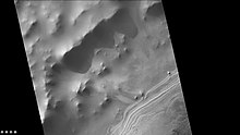
 火星勘測軌道飛行器背景相機拍攝的索思隕擊坑東側邊緣。
 -
 索思隕擊坑內土丘南部的地層,註:這是前一幅東側圖像的放大版。
 -
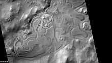
 背索思隕擊坑外的「瑞士乾酪特徵」地層,註:這是前一幅東側圖像的放大版。
 -
 背景相機拍攝的索思隕擊坑西側邊緣。
 -
 索思隕擊坑內西側土丘中的地層,註:這是前一幅西側圖像的放大版。
 -
 索思隕擊坑西側邊緣外的「瑞士乾酪特徵」地層,註:這是前一幅西側圖像的放大版。
![海盜2號軌道器]]拍攝的照片。](/wiki/File:South_crater_383B08.jpg)


另請查看[編輯]
參考文獻[編輯]
- ^ International Astronomical Union (IAU) Working Group for Planetary System Nomenclature (WGPSN). South on Mars. Gazetteer of Planetary Nomenclature. US Geological Survey. [2 February 2021]. (原始內容存檔於2021-01-27).
- ^ Thomas, P. C.; et al. North-south geological differences between the residual polar caps on Mars. Nature. March 2000, 404 (6774): 161–164. Bibcode:2000Natur.404..161T. PMID 10724162. S2CID 4379259. doi:10.1038/35004528.
- ^ Hartmann, William K. A Traveler's Guide to Mars. Workman Publishing. 2003.
- ^ Mangold, Nicolas. Ice sublimation as a geomorphic process: A planetary perspective. Geomorphology. 2011, 126 (1–2): 1–17. Bibcode:2011Geomo.126....1M. doi:10.1016/j.geomorph.2010.11.009.
- ^ Byrne, S.; Ingersoll, A. P. A Sublimation Model for the Formation of the Martian Polar Swiss-cheese Features. AAS/Division for Planetary Sciences Meeting Abstracts (American Astronomical Society). 2002, 34: 837. Bibcode:2002DPS....34.0301B.
- ^ Russell, Patrick. South Pole Residual Cap Swiss-Cheese Terrain Monitoring. The University of Arizona: Lunar and Planetary Laboratory: HiRISE. 26 September 2007 [2 February 2021]. (原始內容存檔於2021-07-29).