舊金山灣區:修订间差异
Johnson.Xia(留言 | 贡献) →气候: 内容扩充 |
Johnson.Xia(留言 | 贡献) →生态: 内容扩充 |
||
| 第95行: | 第95行: | ||
==== 海洋生态 ==== |
==== 海洋生态 ==== |
||
[[File:River_otter_Richmond_Marina_Scott_Campbell_July_29,_2010.jpg|链接=https://en.wikipedia.org/wiki/File:River_otter_Richmond_Marina_Scott_Campbell_July_29,_2010.jpg|替代=An image of river otter sunning on rocks.|缩略图|一群在石头上晒太阳的水濑,摄于[[列治文 (加利福尼亞州)|列治文]]码头]][[File:Beaver_Yearling_Grooming_Alhambra_Creek_2008.jpg|链接=https://en.wikipedia.org/wiki/File:Beaver_Yearling_Grooming_Alhambra_Creek_2008.jpg|替代=An image of a California golden beaver.|缩略图|一只在[[马丁内斯 (加利福尼亚州)|马丁内斯]]{{Translink|en|Alhambra Creek|阿尔罕布拉溪}}的{{Translink|en|Martinez, California beavers|马丁内兹河狸}}]]{{TransH}}[[Martinez, California|Martinez]].|alt=An image of a California golden beaver.]] |
|||
The Bay Area is home to a diverse array of wildlife and, along with the connected [[San Joaquin River Delta]] represents one of California's most important ecological habitats.<ref>{{citeweb|url=http://www.biologicaldiversity.org/campaigns/san_francisco_bay_area_and_delta_protection/|title= San Francisco Bay Area and Delta Protection|publisher=Center for Biological Diversity|accessdate=September 19, 2017}}</ref> California's [[Dungeness crab]], Pacific [[halibut]], and the California [[scorpionfish]] are all significant components of the bay's [[fisheries]].<ref>{{citeweb|url= https://www.wildlife.ca.gov/Fishing/Ocean/Regulations/Fishing-Map/San-Francisco|title=Current California Ocean Recreational Fishing Regulations|publisher=California Department of Fish and Wildlife|accessdate=September 19, 2017}}</ref> The bay's [[salt marsh]]es now represent most of California's remaining salt marsh and support a number of endangered [[species]] and provide key ecosystem services such as filtering pollutants and [[sediment]]s from the rivers.<ref>{{citeweb|url=https://earthobservatory.nasa.gov/IOTD/view.php?id=87379|title=From Salt Production to Salt Marsh|publisher=NASA Earth Observatory|date=February 11, 2016|accessdate=September 19, 2017}}</ref> Most famously, the bay is a key link in the [[Pacific Flyway]] and with millions of [[shorebirds]] annually visiting the bay shallows as a refuge, is the most important component of the flyway south of [[Alaska]].<ref>{{citeweb|url=http://data.prbo.org/apps/pfss/uploads/Reports/SanFranciscoBayShorebirdMonitoringPlan_v1.0_FULL_PRBO_2010CALCC.pdf|title=A Monitoring Plan for Wintering Shorebids in the San Francisco Bay|author=Reiter, Matthew E. et al.,|publisher=California Landscape Conservation Cooperative|date=April 2011|accessdate=September 19, 2017}}</ref> Many [[endangered species]] of birds are also found here: the [[California least tern]], the [[California clapper rail]], the [[snowy egret]], and the [[black crowned night heron]].<ref>{{citeweb|url=http://www.southbayrestoration.org/Fact%20Sheets/FS5.html|title=Threatened and Endangered species|publisher=South Bay Restoration Project|accessdate=September 19, 2017}}</ref> |
|||
There is also a significant diversity of [[salmonids]] present in the bay. [[Steelhead]] populations in California have dramatically declined due to human and natural causes; in the Bay Area, all naturally spawned [[Fish migration|anadromous]] steelhead populations below natural and manmade impassable barriers in California streams from the [[Russian River (California)|Russian River]] to [[Aptos Creek]], and the drainages of San Francisco, San Pablo, and Suisun Bays are listed as threatened under the [[Endangered Species Act|Federal Endangered Species Act]].<ref>{{cite report|title=Central California Coast Steelhead DPS|publisher=NOAA's National Marine Fisheries Service Northwest Regional Office|url=http://www.nwr.noaa.gov/ESA-Salmon-Listings/Salmon-Populations/Steelhead/STCCC.cfm|accessdate=February 15, 2010}}</ref> The Central California Coast [[coho salmon]] population is the most endangered of the many troubled salmon populations on the [[West Coast of the United States|west coast of the United States]], including populations residing in [[tributaries]] to the San Francisco Bay.<ref name=Science>{{cite journal|title=In Central California, Coho Salmon Are on the Brink|author=Greg Miller|journal=Science|date=January 2010|url=http://www.sciencemag.org/cgi/content/full/327/5965/512|accessdate=Feb 15, 2010|doi=10.1126/science.327.5965.512|volume=327|issue=5965|pages=512–3|pmid=20110475}}</ref> Industrial, mining, and other uses of [[mercury (element)|mercury]] have resulted in a widespread distribution of that poisonous metal in the bay, with uptake in the bay's [[phytoplankton]] and contamination of its [[game fish|sportfish]].<ref>{{cite journal|journal=Rev Environ Contam Toxicol|year=2008|volume=194|pages=29–54|title=Mercury in the San Francisco Estuary|author1=Conaway CH|author2=Black FJ|author3=Grieb TM|author4=Roy S|author5=Flegal AR|pmid=18069645|doi=10.1007/978-0-387-74816-0_2|series=Reviews of Environmental Contamination and Toxicology|isbn=978-0-387-74815-3}}</ref> |
|||
Aquatic mammals are also present in the bay. Before 1825, Spanish, French, English, Russians and Americans were drawn to the Bay Area to harvest prodigious quantities of [[North American beaver|beaver]], [[North American river otter|river otter]], marten, fisher, mink, fox, weasel, harbor and [[fur seal]]s and [[sea otter]]. This early fur trade, known as the [[California Fur Rush]], was more than any other single factor, responsible for opening up the West and the San Francisco Bay Area, in particular, to world trade.<ref name=Skinner>{{cite book |author=Skinner, John E. |year=1962 |title=An Historical Review of the Fish and Wildlife Resources of the San Francisco Bay Area (The Mammalian Resources) |url=http://www.estuaryarchive.org/archive/skinner_1962 |publisher=California Department of Fish and Game, Water Projects Branch Report no. 1. Sacramento, California: California Department of Fish and Game |deadurl=yes |archiveurl=https://web.archive.org/web/20110726035239/http://www.estuaryarchive.org/archive/skinner_1962/ |archivedate=July 26, 2011 |df= }}</ref> By 1817 sea otter in the area were practically eliminated.<ref>{{cite report |title=Archeological Research Issues for the Point Reyes National Seashore – Golden Gate National Recreation Area |author=Suzanne Stewart and Adrian Praetzellis |page=335 |url=http://www.sonoma.edu/asc/projects/pointreyes/overview4.pdf |date=November 2003 |publisher=Anthropological Studies Center, Sonoma State University |accessdate=January 10, 2010 }}</ref> Since then, the [[North American beaver|California golden beaver]] has re-established a presence in the [[Alhambra Creek]].<ref>{{citeweb|url=http://www.mercurynews.com/2014/12/21/leave-it-to-beavers-california-joins-other-states-in-embracing-the-rodent/|title=Leave it to beavers: California joins other states in embracing the rodent|publisher=''[[San Jose Mercury News]]''|author=Clark, Samantha|date=August 12, 2016|accessdate=September 19, 2017}}</ref> The [[North American river otter]] which was first reported in [[Redwood Creek (Marin County)|Redwood Creek]] at [[Muir Beach, California|Muir Beach]] in 1996,<ref>{{cite news|title=Get Outside!|work=San Francisco Chronicle|date=April 1966|url=http://www.sfgate.com/getoutside/1996/apr/rwanimals.html|accessdate=March 6, 2011|deadurl=yes|archiveurl=https://web.archive.org/web/20090630084732/http://www.sfgate.com/getoutside/1996/apr/rwanimals.html|archivedate=June 30, 2009}}</ref> has since been spotted in the North Bay's [[Corte Madera Creek (Marin County, California)|Corte Madera Creek]], the South Bay's [[Coyote Creek (Santa Clara County)|Coyote Creek]],<ref>{{cite web|title=Blue Oak Ranch Reserve|publisher=University of California|url=http://nrs.ucop.edu/reserves/blue_oak_ranch/blue_oak.htm|accessdate=March 6, 2011|deadurl=yes|archiveurl=https://web.archive.org/web/20110512020828/http://nrs.ucop.edu/reserves/blue_oak_ranch/blue_oak.htm|archivedate=May 12, 2011|df=mdy-all}}</ref> as well as in 2010 in San Francisco Bay itself at the [[Richmond, California|Richmond Marina]]. Other mammals include the internationally famous [[sea lions]] who began inhabiting San Francisco's [[Pier 39]] after the [[1989 Loma Prieta earthquake]]<ref>{{citeweb|url=https://www.pier39.com/the-sea-lion-story/|title=Sea Lions and the Sea Lion Story|publisher=Pier 39|accessdate=September 19, 2017}}</ref> and the locally famous [[Humphrey the Whale]], a [[humpback whale]] who entered San Francisco Bay twice on errant migrations in the late 1980s and early 1990s.<ref>{{cite book |author1=Tokuda, Wendy |author2=Hall, Richard |author3=Wakiyama, Hanako (ill.) |title=Humphrey the lost whale: a true story |publisher=Heian Intl Publishing Company |location=Union City, California |date=1986 |isbn=0-89346-270-5 |oclc=779021889}}</ref> [[Bottlenose dolphin]]s and [[Harbour porpoise|harbor porpoises]] have recently returned to the bay, having been absent for many decades. Historically, this was the northern extent of their warm-water species range.<ref>{{citeweb|url=http://www.oursausalito.com/fun-sausalito-activities/marine-mammal-center/dolphins-harbor-porpoise-project.html|title=Dolphins and Porpoises in San Francisco Bay|publisher=Our Sausalito|author=Roger, AnnaMarie|accessdate=September 21, 2017}}</ref> |
|||
==== 鸟类 ==== |
==== 鸟类 ==== |
||
2018年7月17日 (二) 02:03的版本
| 此條目目前正依照en:San Francisco Bay Area上的内容进行翻译。 (2018年7月1日) |
| 此條目翻譯自英語維基百科,需要相關領域的編者協助校對翻譯。 |
| 旧金山湾区 | |
|---|---|
| 组合城市 | |
 | |
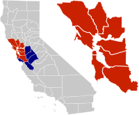 湾区在加州的位置。 9个县组成的湾区 综合统计区中的另外几个县 | |
| 坐标:37°49′N 122°22′W / 37.81°N 122.37°W | |
| 国家 | |
| 州份 | |
| 分区 | |
| 主要城市 | |
| 面积[1] | |
| • 9个县 | 6,966 平方英里(20,000 平方公里) |
| • 综合统计区 | 10,191 平方英里(30,000 平方公里) |
| 最高海拔[2] 哥白尼顶点 | 4,360 英尺(1,330 公尺) |
| 最低海拔[3] 艾尔维索 | −13 英尺(−4 公尺) |
| 人口(2017) | |
| • 9个郡 | 776万[4] |
| • 9个郡密度 | 1,102.5人/平方英里(425.7人/平方公里) |
| • 综合统计区 | 884万[5] |
| • 综合统计区密度 | 859人/平方英里(332人/平方公里) |
| 时区 | 太平洋时区(UTC−8) |
| • 夏时制 | 太平洋时区#夏令时间(UTC−7) |
| Area codes | 408/669, 415/628, 510, 650, 707, 925[6] |
舊金山灣區(英語:San Francisco Bay Area),简称灣區(The Bay Area),是位於美國加利福尼亞州北部的區域及都會區,位於沙加緬度河下游出海口的舊金山灣和聖帕布羅灣四周。湾区的范围尚有争议,但普遍认可的范围包含西側的舊金山,南側的聖馬刁郡、圣克拉拉谷地區,東側的阿拉米达郡、康特拉科斯塔县、索拉诺县,以及北側的馬林郡、納帕郡和索诺马县,共9个县、101个城市。广义上,湾区也包括附近不沿海的其他郡,例如聖貝尼托縣、聖華金縣、斯坦尼斯劳斯县和聖塔克魯茲縣,这12个县合称加利福尼亚州圣何塞-旧金山-奥克兰综合统计区,為美國西岸第二大(僅次於洛杉磯)、全美国第五大[7]的都会区。
湾区传统9县的總人口數在768萬左右,而范围更大的综合统计区则有875萬人口。[8]同时,湾区的族裔也非常多样化,过半的地区有亚裔、非裔、西班牙裔和太平洋岛民居住,这些族裔也有不小的影响力。也是美國人均所得最高的地區之一。
据考古的证据显示,湾区有人类定居的历史可以追溯到公元前3000年。在18世纪时,湾区的主要居民是欧隆人,后来西班牙的殖民者,在Gaspar de Portolá的带领下进入了此地区,成为了欧洲人首次有记载的到来。
不像其他以單一城市為中心的大都會區,舊金山灣區裡有數個獨特的城郊中心。分別位於舊金山灣西南東三側的舊金山、奧克蘭、聖荷西,為區內的三大都市。雖然聖荷西在1990年人口普查時超越舊金山,成為灣區人口最多的城市,但建城歷史最久的舊金山,仍舊是灣區的商業與文化中心。在墨西哥于1821年宣布独立后,附近地区落入了墨西哥政府的控制,直到美国在1846年美墨戰爭时占领。随后,金子的发现吸引了大量的淘金者,他们大多数都是通过湾区的码头登陆的。在加州刚成立时,州議會的办公场所一直在湾区的三个城市里流动,直到永久首府萨克拉门托的成立。1906年,旧金山和周边地区遭到了一场大地震的重创,但很快便恢复了原先的秩序,并在1915年成功举办了巴拿马万国博览会。第二次世界大战期间,湾区由亚太战区管辖,并发挥了重要作用,例如旧金山的梅森堡垒当时就是美军的主要装卸码头。1945年,联合国宪章在旧金山签署,标志着联合国的成立。1951年,旧金山条约签订,美国与日本结束战争状态。自此之后,湾区经历了各种各样的政治、文化和艺术运动,并发展出独特的本地流派,也成为了進步主義的摇篮。经济上,湾区在战后大力发展金融产业和科技产业,并创造出了超过7000亿美元的生产总值,也成为了500强企业聚集第二多的地区。
虽然已经城市化,但是湾区还是加州最为重要的生态栖息地,承担着重要的生态作用,例如滤除河流里的污染物和沉淀物,以及孕育着多种濒危物种。湾区还因为板块运动,有着多样化的地形,同时,因为湾区在六个主要板块的交界处,也面临大地震的困扰。湾区有着温和的气候,也非常适合户外运动。在湾区就有7支专业的球队。湾区也是各种艺术形式的中心,还有着很多高等教育院校,例如斯坦福大学和加利福尼亞大學柏克萊分校。
地區

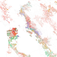
旧金山湾区没有准确的划分。同时,由于湾区地貌形成的独特发展模式,和湾区内三个重要城市催生的密集的交通网络,政府和民间对湾区的理解有不小的差距。[9]因此,一位加州大學柏克萊分校的地理学教授Richard Walker曾说“在美国,没有比旧金山湾区更难定义的地区了”。
大部分当地政府,例如加利福尼亚州水资源管理委员会[10] 、湾区空气质量管理局[11] 、旧金山湾保护协会[12] 、大都会交通委员会(旧金山湾区)[13] 、湾区政府协会[14] 都认为靠近旧金山-圣帕布罗-休松湾一带的9个县是湾区的组成。这些县包括西側的舊金山,南側的聖馬刁郡、圣克拉拉谷地區,東側的阿拉米达郡、康特拉科斯塔县、索拉诺县,以及北側的馬林郡、納帕郡和索诺马县。大都会交委和湾区政府协会还提议以9县(而不是综合统计区的12县)作为统计区的范围。[15]
而联邦政府的机构却有不同的定义。美国行政管理和预算局将广义12县划为前文所述的综合统计区,作为湾区的范围。[16]另外,联邦通信委员会将传统9县加上科卢萨县、萊克縣和门多西诺县划为“旧金山-奥克兰-圣何塞”广播分区,却排除了索拉诺县。[17]
在湾区居民的眼中,湾区可以划分为东湾、北湾、南湾、半岛和旧金山五个区域。虽然旧金山也在旧金山半岛上,但是当地人却习惯将旧金山市和半岛的其他县市分开看待。[18][19]
北灣
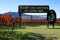
在金門大橋北方的舊金山灣區通常被稱做北灣(North Bay)。這个區包含了馬林縣,也向北延伸至索諾馬縣(Sonoma County)和納帕縣(Napa County),并向東延伸至索拉諾縣(Solano County)。除了一小部份地區外,北灣是一個極為富有的地方:馬林縣和索诺玛县在东西两面都临海,而且有着密集的山丘和树林。這裡的都市化程度也比灣區其他地方來得小,大部份為未開發的土地與農田。其中索诺玛和纳帕县因为葡萄园酿酒厂而享誉国际。
馬林縣經常被列為全國最富有的行政區,而索拉諾縣南部是重工業區, 許多石油公司皆在此建立煉油廠。另外,东部的瓦列霍县也是湾区里发展速度最快的地区。[20]
北灣也是灣區裡唯一沒有通勤鐵路服務的地區,不過利用既有鐵路修建的SMART通勤鐵路已於2016年通車。金門大橋是此區往舊金山唯一的道路,列治文-聖拉斐爾大橋(580號州際公路)和卡齊尼茲大橋(80號州際公路)通往東灣列治文,貝尼夏大橋(680號州際公路)通往東灣北端馬丁尼茲市。較小的人口密度與跟灣區其他地區無陸地直接相連是北灣缺乏公共交通工具的主要原因。
舊金山
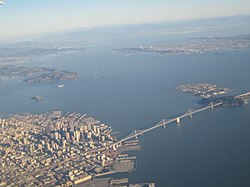
舊金山市郡在舊金山灣區裡,常被在地理和文化上被列為自己的一個項目裡,當地經常簡稱它為「The City」。舊金山與它的鄰居在北方、東方、和西方被水隔開,在南方則以行政區線分開。舊金山是舊金山灣區長久以來的文化、財經、和都市中心。在灣區歷史的很長一段時間裡,舊金山也是灣區的主要人口聚集地。但因為市地不大(47平方英里,城市人口密度是美國的第二高,僅次於紐約市),限制了人口成長,於是自1906年舊金山大地震後,大部分的人口增長都是在附近其他縣和城市。
東灣
東灣以奥克兰为中心,包括康特拉科斯塔縣以及阿拉米達縣。位於東灣的城市有列治文、奧伯尼、伯克利、愛莫利維爾、奧克蘭、阿拉米達、海沃德、聯合市、纽华克、費利蒙等位于位于高度城镇化的西岸的城市,和卡斯特羅谷、馬丁尼茲、康科德、普萊森特希爾、核桃溪等城市。另外,东湾还有几块“飞地”,例如三谷地区(包括都伯林、普萊森頓、丹維爾以及聖拉蒙等城市)。[21]許多大公司皆於東灣設立總部, 包括 西夫韋, 雪佛龙, 24 Hour Fitness 和 Kaiser Permanente。東灣有眾多大型公園和開放空間,是一個很適合休閒和健行的地方。

半島
舊金山半島介於舊金山市以南、南灣以北,不包括位于半岛尖的旧金山市,虽然名字来源于此。當地常簡稱為「半島」(The Peninsula)。半岛的东岸有着密集的人口,而临近太平洋的西岸则相对人口较少,却有着开阔的地带,非常适合登山。這地區由聖馬刁縣的數個中小型城市(如戴利城)、近郊社區和聖塔克拉拉縣西北部份(包括帕羅奧圖、山景城、和洛思阿图斯)所組成,[22]也包含數個太平洋岸邊的城鎮,如柏思域加(Pacifica)和半月灣。雖然有許多富有家庭居住在此,半島居民的組成是相當多樣化的。這裡許多城鎮在二次世界大戰前僅是鄉村生活的中心,戰後,許多中產和富有家庭遷移至此,也帶動當地發展。自1980年代起,中產和富有家庭的數量因矽谷高科技產業的繁榮而急速成長。許多來自外國的家庭,也是居民組成多樣化的原因之一。
南灣

旧金山湾南部位于圣克拉拉谷的北端,包括以圣何塞为中心、大部分圣克拉拉郡的城市。[23]許多高科技公司聚集在此,这一地区常以“硅谷”代称。[24]南灣的主要城市包括聖荷西、圣克拉拉、森尼韦尔、庫比蒂諾、以及吉尔罗伊等地。一般來說,南灣的範圍相當於整個聖塔克拉拉縣,然而聖塔克拉拉縣西北部一般被認為是半島的一部份。聖荷西在2010年人口普查有945,942人,是灣區最大城市、加州第三大城,同時也是全美第十大城。
地理

气候
湾区位于地中海式气候带上,有湿润温和的冬季和干旱的夏季,是加州沿海典型的气候类型。
[25]寒冷的加利福尼亞洋流深深地影响着沿岸的气候,它从各个山口穿过连绵起伏的群山。[26]降雨方面,湾区有着分明的干湿季。湿润的季节大约是11月到次年3月,这时的降雨量占年降雨量的八成。在南湾和内陆,湿季是湿冷的,而干季则是干热的。[26]而旧金山和金门海峡附近,干季会经常出现大雾。[27]
湾区复杂的地形促成了多样化的微氣候,导致一些邻近地区也有着较大的温度和气候差异。[25][28]在旧金山,自然地形和建造的楼宇决定了风和雾的移动,也导致了街区之间不同的微气候。在金门海峡附近,来自太平洋的风和雾会穿过山丘的阻碍,深入湾区。[28]在夏季,加州内陆的山谷形成的热气会形成一个低压地带,吸引来自北太平洋高压的风穿过金门海峡,并形成旧金山典型的大雾天气。[27]那时,大雾的渗透会达到最高峰[28],而内陆和南湾却是阳光明媚又干燥,[26]形成一年中最明显的微气候差异。
在旧金山半岛沿岸,圣克鲁兹山脉之间的山谷,以及水晶泉水库的低洼处,使内陆也具有海滨的天气,也使得半岛上的城市,甚至是圣何塞都变得凉快。这种天气也时不时给旧金山机场添堵。金门海峡北方的马林县,在缪尔森林北部的两个山谷使冷空气直达马林高地,甚至是更北部的圣罗莎。[29]在更内陆的东湾,沿海气候从金门海峡一路穿过伯克利丘、尼尔斯峡谷和海沃德山口,直达利佛摩谷和阿尔塔蒙特山口,使这里有着非常强劲的风力。因此,这里也有着全世界最大的风力发电厂。更北一些的卡奎内兹海峡使海洋气候一路到达圣华金河三角洲,使斯托克顿河沙加緬度比中央谷地的城市更加凉爽。[30]
<tbody></tbody>| 部分城市的最高和最低温
单位为℉(℃) | ||||||||||||
|---|---|---|---|---|---|---|---|---|---|---|---|---|
| 城市 | 一月 | 二月 | 三月 | 四月 | 五月 | 六月 | 七月 | 八月 | 九月 | 十月 | 十一月 | 十二月 |
| 費爾菲爾德[31] | 55/39 (13/4) | 61/42 (16/6) | 66/45 (19/7) | 71/47 (22/8) | 78/52 (26/11) | 85/56 (29/13) | 90/58 (32/14) | 89/57 (32/14) | 86/56 (30/13) | 78/51 (26/11) | 65/44 (18/7) | 55/39 (13/4) |
| 奥克兰[32] | 58/44 (14/7) | 67/47 (19/8) | 64/49 (18/9) | 66/50 (19/10) | 69/53 (21/12) | 72/55 (22/13) | 72/56 (22/13) | 73/58 (23/14) | 74/57 (23/14) | 72/54 (22/12) | 65/49 (18/9) | 58/45 (14/7) |
| 旧金山[33] | 57/46 (14/8) | 60/48 (16/9) | 62/49 (17/9) | 63/49 (17/9) | 64/51 (18/11) | 66/53 (19/12) | 66/54 (19/12) | 68/55 (20/13) | 70/55 (21/13) | 69/54 (21/12) | 63/50 (17/10) | 57/46 (14/8) |
| 圣何塞[34] | 58/42 (14/6) | 62/45 (17/7) | 66/47 (19/8) | 69/49 (21/9) | 74/52 (23/11) | 79/56 (26/13) | 82/58 (28/14) | 82/58 (28/14) | 80/57 (27/14) | 74/53 (23/12) | 64/46 (18/8) | 58/42 (14/6) |
| 圣罗莎[35] | 59/39 (15/4) | 63/41 (17/5) | 67/43 (19/6) | 70/45 (21/7) | 75/48 (24/9) | 80/52 (27/11) | 82/52 (28/11) | 83/53 (28/12) | 83/52 (28/11) | 78/48 (26/9) | 67/43 (19/6) | 59/39 (15/4) |
生态
生态与地形
海洋生态


The Bay Area is home to a diverse array of wildlife and, along with the connected San Joaquin River Delta represents one of California's most important ecological habitats.[36] California's Dungeness crab, Pacific halibut, and the California scorpionfish are all significant components of the bay's fisheries.[37] The bay's salt marshes now represent most of California's remaining salt marsh and support a number of endangered species and provide key ecosystem services such as filtering pollutants and sediments from the rivers.[38] Most famously, the bay is a key link in the Pacific Flyway and with millions of shorebirds annually visiting the bay shallows as a refuge, is the most important component of the flyway south of Alaska.[39] Many endangered species of birds are also found here: the California least tern, the California clapper rail, the snowy egret, and the black crowned night heron.[40]
There is also a significant diversity of salmonids present in the bay. Steelhead populations in California have dramatically declined due to human and natural causes; in the Bay Area, all naturally spawned anadromous steelhead populations below natural and manmade impassable barriers in California streams from the Russian River to Aptos Creek, and the drainages of San Francisco, San Pablo, and Suisun Bays are listed as threatened under the Federal Endangered Species Act.[41] The Central California Coast coho salmon population is the most endangered of the many troubled salmon populations on the west coast of the United States, including populations residing in tributaries to the San Francisco Bay.[42] Industrial, mining, and other uses of mercury have resulted in a widespread distribution of that poisonous metal in the bay, with uptake in the bay's phytoplankton and contamination of its sportfish.[43]
Aquatic mammals are also present in the bay. Before 1825, Spanish, French, English, Russians and Americans were drawn to the Bay Area to harvest prodigious quantities of beaver, river otter, marten, fisher, mink, fox, weasel, harbor and fur seals and sea otter. This early fur trade, known as the California Fur Rush, was more than any other single factor, responsible for opening up the West and the San Francisco Bay Area, in particular, to world trade.[44] By 1817 sea otter in the area were practically eliminated.[45] Since then, the California golden beaver has re-established a presence in the Alhambra Creek.[46] The North American river otter which was first reported in Redwood Creek at Muir Beach in 1996,[47] has since been spotted in the North Bay's Corte Madera Creek, the South Bay's Coyote Creek,[48] as well as in 2010 in San Francisco Bay itself at the Richmond Marina. Other mammals include the internationally famous sea lions who began inhabiting San Francisco's Pier 39 after the 1989 Loma Prieta earthquake[49] and the locally famous Humphrey the Whale, a humpback whale who entered San Francisco Bay twice on errant migrations in the late 1980s and early 1990s.[50] Bottlenose dolphins and harbor porpoises have recently returned to the bay, having been absent for many decades. Historically, this was the northern extent of their warm-water species range.[51]
鸟类
水文
历史

史前和原住民时期
虽然美洲在2万年前就有人类定居了[52] ,但是直到公元前3000年才有人类在湾区活动的痕迹,且大部分在沿海一带。另外,还有在马林县雷耶斯海岬的痕迹显示着更早的定居情况[53] 。当欧洲殖民者到达时,他们见到的是定居在此的密沃克人和欧隆人。这些原住民可能是西伯利亚部落人的后代,他们的祖先在公元前1000年,为了追随三文鱼的迁徙潮,跨过了白令海峡,来到了这里。[54]欧隆人有40多个部落散落在旧金山湾和蒙特雷湾岸边。[55]
殖民和易手
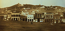
1575年,一群西班牙的殖民者,在塞巴斯蒂昂·罗德里格斯·索洛门霍的带领下,在雷耶斯海角附近的德雷克斯湾登陆,并成为了第一批在湾区落脚的欧洲人。4年后,法蘭西斯·德瑞克在同一个地方登陆,并为英国占领了一块地盘。[56]然而,旧金山湾周边却一直没有被光顾,直到嘉斯帕·德伯尔托拉在1769年穿过金门海峡。[56]之后,又有不少来自西班牙的探险者到来并占领了一些地区,例如胡安·鮑提斯塔·德·安萨占领了旧金山要塞,加布里埃尔·莫拉加从要塞出发,带领他的队伍经过了圣何塞、帕切科山口,最后到达聖華金谷。[57][56]
1821年,墨西哥从西班牙独立,湾区成为了上加利福尼亞省的一部分,之后便有大牧场建立在此,还有来狩猎的美国游客。[58]然而,墨西哥的治理没持续多久,在1846年,一群美国移民占领了索诺马广场并宣布了加利福尼亚共和国的成立,[58] 接着美墨戰爭爆发,美国的约翰·蒙哥马利船长在6月16日驾着朴茨茅斯号进入旧金山湾,随后在7月9日占领了芳草地(今天的旧金山),并在花园角升起了美国国旗,[59]宣告加州加入联邦。后世为了纪念这位船长,将旧金山的一条街命名为蒙哥馬利街。
19世纪和淘金热
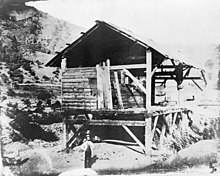
1848年,詹姆斯·马歇尔在美利坚河里发现了金子,引爆了淘金热。在接下来的半年内,4000人在这条河的流域淘金,每天能发现价值5万美元的金子。[60]抱着大赚一笔的希望,一大群淘金者涌向了萨特磨坊。湾区一时万人空巷,包括工人、职员、服务员和奴隶在内的居民都加入了淘金的队伍。加州的第一份报纸《加州人》也因为缺少员工,被迫宣布暂停出版。[60]到了1849年末,淘金的新闻已是众所周知,每周都有1000人涌入湾区,前往加州内陆,[61]其中包括第一批成规模华人移民。[62] 淘金潮在当时非常大,以至成百艘船都被前往淘金的船员遗弃在了旧金山的港口。[63]史无前例的移民潮使尚未成熟的政府机构失去作用,军方也未能阻止官兵擅离职守。于是,不少治安队自此诞生,但是除了维持秩序的主业,不少小队也参与屠杀、驱赶美洲原住民的勾当。在淘金热接近尾声时,已有三分之二的原住民遭到屠杀。[64]
在这期间,加州制宪会议也在进行中,以决定加州成为美国一州的申请。在申请通过后,州的首府曾多次变更,从1849-1851年间的聖荷西,到1851-1852年间的瓦列霍,再到1852-1853年间的贝尼西亚,最后在1854年才确定在萨克拉门托。[65]随着淘金热逐渐褪去,淘金者积累的财富促成了富国银行和加利福尼亚银行的成立,而迁徙来的淘金者则成为了此地主要的人口组成。第一條橫貫大陸鐵路的建造吸引了大批中国的劳工,使亚裔人口大幅增长。到1870年时,旧金山有8%的人口为亚裔。[66]铁路的竣工使湾区和美国其他地方相连,使贸易更加快捷高效,也加速了湾区的城市化。[67]
进入20世纪后

1906年4月18日清晨,一场大地震发生在旧金山的市中心。[68]据军方救援队的估计,地震直接造成旧金山498人、圣罗莎64人、圣何塞102人,总共近700人死亡。现在的研究认为,总共的死亡人数可能超过了3000人,同时还有2.8万栋房屋倒塌。[69]重建工作很快展开。 阿马迪奥·贾尼尼,时任意大利银行(今美國銀行)的老板,设法在大火蔓延之前取出了自家银行金库里的钱,成为了当时唯一具有流通资金、可以放贷支持重建工作的银行。[70]为了保障湾区的供水,国会随后通过了几年前被否决的、在優勝美地國家公園Hetch Hetchy河谷建造水库的计划,保证了湾区240万人的饮用水来源。虽然地震使旧金山湾区的主导地位让位给了洛杉磯都會區,但是旧金山在1915年时已基本恢复了元气,并通过举办巴拿马万国博览会而扬名世界。[70]

在1929年華爾街股災和随后的大萧条中,旧金山的银行都坚持了下来,[71]同时为了增加就业,旧金山上马了两项大建设:连接马林县的金门大桥[72],和连接奥克兰的海灣大橋。[73] 在美国宣布参加二战后,湾区成为了主要的军事枢纽。其中,索萨利托和东湾建成了大型船坞以建造战舰,梅森堡垒成为了美军亚洲-太平洋战区主要的装卸码头。[74] 战争结束后,1945年,联合国宪章在旧金山签署,联合国正式成立,以避免类似浩劫的重演,[75] 随后在1951年,日本在旧金山向同盟國正式投降并在次年签署舊金山和約。[76]湾区在战后迎来了大规模的移民潮,人口也疾速增加。在1950-1960年间,旧金山接纳了超过10万名新居民,东湾城市的人口也翻了一番,而戴利城的人口增加了3倍,圣克拉拉的人口更增加了4倍。[74]

从60年代开始,湾区和北加州成为了1960年代反文化运动的中心,其中伯克利的电报大道和旧金山的海特-阿什伯里街区成为了运动的大本营。[77] 在旧金山(歌曲)发表后,更是吸引了大批支持者,并形成了愛之夏运动。[78]在接下来的几十年内,湾区更是成为了各种思潮的摇篮,例如新左翼、學生運動、反越战示威、反戰運動、黑人权力和LGBT權利運動。[77] 同时,圣何塞和南湾地区从第一产业,迅速转型为高科技产业。[79]弗雷德里克·特曼,这位在二战中在哈佛大学领导着秘密项目的教授,加入了史丹佛大學并改组了学校的工学院。他的学生,包括大衛·普克德和威廉·惠利特,引领了硅谷后来的高科技革命。[80]1955年,肖克利半導體實驗室在斯坦福附近成立,成为了湾区第一家半导体公司。虽然实验室后来遇到了财务困境,但是它的成立还是吸引了大批科创人员的到来,并最终形成了今天的硅谷。[81]
1989年,在1989 World Series比赛中,地震再次来袭,并损坏了大量的基建,包括海灣大橋和赛普勒斯街高架桥。[82] 不过,湾区的科技产业依然在发展,硅谷的发展速度也不断提高,以至1990年时,圣何塞的人口已经超过了旧金山。[83]

随后的信息化给湾区在高科技产业带来了不小的泡沫经济——互联网泡沫。在2000年左右,泡沫开始崩溃,导致产业持续缩水, 甚至差点造成市场的崩溃。随后,亚马孙和谷歌着手稳定了市场,并使自己的市值得到了增长。[84]
政治运动

即使科技的不断发展改变了此地的经济结构,进步主义依然引领着这里的政治环境。在世纪之交,非拉丁裔白人,作为美国最大的族裔,却只占湾区人口的一半,因为其他少数族裔在不断涌入。[85]在此期间,湾区是LGBT權利運動的大本营:2004年,旧金山成为全美国第一个向同性伴侣颁发结婚证的城市,[86]而4年后,湾区的大部分选举人否决了在州宪法中限制同性婚姻的8号提案,虽然此提案还是以微弱优势通过了。[87]湾区也是诸多关于种族和经济不平等示威的重要发源地。2009年,一位非裔美国人奥斯卡·格兰特被湾区捷运警方击毙,旋即引起了湾区大范围的示威,甚至在奥克兰还出现了暴乱[88]。奥斯卡·格兰特的名字还在2年后的占领奥克兰,一场关于种族和经济不平等的示威中,被当作示威者的象征。[89] 在2017年初,唐納·川普就任美国总统后,湾区成为了“反特朗普”的大本营,并与同期举行的2017年女性大游行互相呼应,[90] 随后又出现了多次特朗普和湾区多位政治、文化、商业领域的人物在族裔和移民问题上的争执。[91][92]
人口
| 歷史人口數 | |||
|---|---|---|---|
| 調查年 | 人口 | %± | |
| 1860年 | 114,074 | — | |
| 1870年 | 265,808 | 133.0% | |
| 1880年 | 422,128 | 58.8% | |
| 1890年 | 547,618 | 29.7% | |
| 1900年 | 658,111 | 20.2% | |
| 1910年 | 925,708 | 40.7% | |
| 1920年 | 1,182,911 | 27.8% | |
| 1930年 | 1,578,009 | 33.4% | |
| 1940年 | 1,734,308 | 9.9% | |
| 1950年 | 2,681,322 | 54.6% | |
| 1960年 | 3,638,939 | 35.7% | |
| 1970年 | 4,628,199 | 27.2% | |
| 1980年 | 5,179,784 | 11.9% | |
| 1990年 | 6,023,577 | 16.3% | |
| 2000年 | 6,783,760 | 12.6% | |
| 2010年 | 7,150,739 | 5.4% | |
| 2017年估計 | 7,756,158 | [93] | 8.5% |
| 备注:9县总人口[85] | |||
根据2010年美國人口普查,9县的人口一共715万,其中男性占49.6%,女性50.4%。[94]另外,将近32%,即230万人出生于外国。[95] 2010年时的各族裔组成是:52.5%白人(其中42.4%非拉丁裔、10.1%拉丁裔)、23.5%拉丁裔(其中17.9%墨西哥人、1.3%萨尔瓦多人、0.6%危地马拉人、0.6%波多黎各人、0.5%尼加拉瓜人、0.3秘鲁人和0.2%古巴人)、23.3%亚裔(其中7.9%华人、5.1%菲律宾人、3.3%印度人、2.5%越南人、1%韩国人、0.9%日本人、0.2%巴基斯坦人、0.2%柬埔寨人、0.2%老挝人、I0.1%泰国人和0.1%缅甸人)、6.7%非裔美国人、0.7%美洲原住民和阿拉斯加原住民、0.6%太平洋岛民、 5.4%多族裔和10.8%其他族裔的。[96] 在湾区的诸多城市里,瓦列霍、休森市、奥克兰、圣利安卓、費爾菲爾德和列治文是族裔最多样化的城市。[97]

基于地理因素,非拉丁裔白人成为了马林、纳帕和索诺玛三县最大的族裔。[98]白人在东湾东部的城市,例如利佛摩和核桃溪,也是占多数的族裔。[98] 旧金山的北滩被称作“小義大利”,曾经也是主要的意大利裔社区。旧金山和马林县都有着不少犹太人。[99]拉丁裔居住在湾区各处,其中聖塔克拉拉縣的人数最多,而康特拉科斯塔县的增长速度最快。[100]纳帕县最多的是墨西哥裔,而旧金山最多的则是中美洲人,[101]他们主要聚集在使命区,又以萨尔瓦多和危地马拉人为多数。[102]
相比于美国其他地方,亚裔在湾区有着不小的人口,尤其是在戴利城,58.4%的人口是亚裔,是全美国最多的(不计夏威夷)。[103] 亚裔在費利蒙也占人口的大多数,在森尼韦尔和圣克拉拉也有不少。另外,圣何塞和旧金山分别是全美国亚裔人口第三和第四多的城市。[104]在旧金山,华裔占人口的21.4%,是该市最大的族群。[105] 圣克拉拉县,以及东湾,有着不少的印度裔。[106] 此外,湾区还有38.2万菲律賓裔,是最大的菲裔居住地。他们大多数居住在美利堅峽谷、戴利城、费尔菲尔德、瓦列霍和南旧金山。[107]另有超过10万越南裔住在圣何塞市区,使圣市成为了最多越南人的城市。[108] 另外,在圣克拉拉郡还有一共可观的韓裔社区。[109] 东湾的列治文和奥克兰,以及北湾的聖羅莎有着不少老挝人和柬埔寨人社区。[110] 一些太平洋岛民,例如汤加人和萨摩亚族多数聚集在东帕罗奥图,占当地人口的7%。[111]
非裔美国人曾经是旧金山主要的人口:在1970年时有七分之一的人口为非裔。非裔居多使旧金山得到了“西海岸哈莱姆”的称号,也使当地的爵士乐发展迅速。如今非裔多数居住在东湾和北湾,包括奥克兰和安條克。[112] 圣罗莎的南园区曾是主要的非裔社区,直到80年代大批拉丁裔移民迁入。[113] 其他有着大量非裔的城市有瓦列霍(28%)[114] 、里奇蒙(26%)[115] 和东帕罗奥图(17%)[116]。
由于湾区的经济主要为创新和高科技产业,此地区的受教育程度也较高。其中,87.4%的居民有初中以上的学历,[117]而46%的成年人有受过高等教育。[118]
得益于旧金山、奥克兰和圣何塞三个“经济引擎”,湾区一直美国最富有的地区之一。其中,普莱森顿是全国家庭收入第二高的城市。然而,考虑到湾区较高的生活成本,这个收入水平就显得没那么突出了。[119]
到2014年,湾区的贫富差距已经非常明显:工薪阶层中,收入最高的10%和最低10%,他们的工资相差11倍有多。[120]另外,布鲁金斯学会的研究也指出,排除了湾区几个县的旧金山都会统计区,在全国所有都会统计区中,有着第三大的贫富差距。[121]在2007年发布的福布斯美国400富豪榜中,有47位是湾区的居民,其中13位在旧金山,使旧金山成为了全球范围内,富豪第七多的城市。这些富豪包括著名的史蒂夫·乔布斯、乔治·卢卡斯、查尔斯·舒瓦博。其中,最富有的是甲骨文公司的拉里·埃里森,他有着240亿美元的资产。[122]在2009年,一份凯捷公司的研究指出,在旧金山-奥克兰-圣何塞一带,有4.5%的居民有超过100万美元的资产,是全国最多的,甚至超过了紐約都會區。[123]另一方面,从2007年起,低收入群体的收入降低了9%,其中收入最少的10%的平均工资只有2万美金。[120]| 按照族裔人口排序的县列表 | ||||||||
|---|---|---|---|---|---|---|---|---|
| 县 | 类型 | 人口 | 白人 | 其他 | 亚裔 | 非裔 | 原住民 | 西班牙裔 |
| 阿拉米达 | 县 | 1,494,876 | 46.2% | 13.8% | 26.2% | 12.5% | 1.3% | 22.2% |
| 康特拉科斯塔 | 县 | 1,037,817 | 63.2% | 12.5% | 14.3% | 9.1% | 0.5% | 23.9% |
| 马林 | 县 | 250,666 | 79.9% | 11.0% | 5.6% | 3.0% | 0.2% | 14.0% |
| 纳帕 | 县 | 135,377 | 81.3% | 8.9% | 6.8% | 2.0% | 0.3% | 31.5% |
| 旧金山 | 县市合一 | 870,887 | 48.5% | 11.3% | 33.3% | 6.1% | 0.9% | 15.1% |
| 圣马刁 | 县 | 711,622 | 59.6% | 11.1% | 24.6% | 2.9% | 1.8% | 24.9% |
| 圣克拉拉 | 县 | 1,762,754 | 50.9% | 13.8% | 31.8% | 2.6% | 0.4% | 26.6% |
| 索拉诺 | 县 | 411,620 | 52.1% | 17.6% | 14.4% | 14.6% | 1.4% | 23.6% |
| 索诺玛 | 县 | 478,551 | 81.6% | 11.3% | 4.0% | 1.2% | 1.5% | 24.3% |
| 按照收入排序的县列表 | |||||
|---|---|---|---|---|---|
| 县 | 类型 | 人口 | 人均收入 | Median household income | Median family income |
| 阿拉米达 | 县 | 1,494,876 | $34,937 | $70,821 | $87,012 |
| 康特拉科斯塔 | 县 | 1,037,817 | $38,141 | $79,135 | $93,437 |
| 马林 | 县 | 250,666 | $54,605 | $89,605 | $113,826 |
| 纳帕 | 县 | 135,377 | $35,309 | $68,641 | $79,884 |
| 旧金山 | 县市合一 | 870,887 | $46,777 | $72,947 | $87,329 |
| 圣马刁 | 县 | 711,622 | $45,346 | $87,633 | $104,370 |
| 圣克拉拉 | 县 | 1,762,754 | $40,698 | $89,064 | $103,255 |
| 索拉诺 | 县 | 411,620 | $29,367 | $69,914 | $79,316 |
| 索诺玛 | 县 | 478,551 | $33,119 | $64,343 | $78,227 |
犯罪问题
据统计,湾区最常见的是暴力和财产犯罪。历史上,暴力犯罪经常出现在东湾的奥克兰、里奇蒙和安条克,以及半岛上的东帕罗奥图、北湾的瓦列霍和旧金山。[124]奥克兰是全国谋杀案第18多、人均暴力犯罪率第3高的城市。[125]在2015年联邦调查局的报告中,奥克兰以千分之16.9的案发率,成为了湾区城市中,暴力犯罪最多的城市,而瓦列霍以千分之8.7紧随其后。另外,圣帕布罗、安条克和旧金山却不在前五的名单内。在2013-2014年间,曾有着最高谋杀案发生率的东帕罗奥图,暴力犯罪减少了65%,奥克兰的案发率也减少了15%。[126]然而,在世纪初还是全国大城市中最安全的圣何塞,却出现了暴力犯罪的增长。[127]犯罪率最低的城市有位于半岛上的洛思阿圖斯和福斯特城、东湾的圣拉蒙和丹维尔,以及南湾的薩拉托加和库比蒂诺。2015年,湾区有45座城市没有发生凶杀案,其中最大的是戴利城[128]。
政府与政治
交通
旧金山湾区的交通离不开各种设施之间的配合,如发达的公路、桥梁、隧道、高速路、铁路、机场、轮渡,以及单车和人行通道。这些设施的建造、维护和运营由多个机构负责,包括加州交通部、旧金山交通局和大都会运输委员会。[129]这些机构共同管理着州際公路、州道、2个地铁系统、2个通勤列车机构、8座跨湾大桥、跨湾渡轮、当地的公交车、[130]3座国际机场(旧金山、奧克蘭和圣何塞三座机场)[131],以及纵横交错的公路、隧道和步行道,例如旧金山湾绿道。[132]
湾区一共有二十多个公共交通运营商,这些运营商的线路和覆盖区域各有不同,又有部分重叠,而他们的互相配合也保证了湾区交通的效率。大部分运营商都接受路路通卡,一种湾区通用的储值车票。
陸上交通
高速公路與橋樑
灣區的高速公路分為州際公路系統、加利福尼亚州州道系統及101号美国国道。80號州際公路由東北方進入灣區,沿海灣大橋至舊金山市區為西端點,其他的州際公路均編為80號公路的支線,280號及680號州際公路被視為灣區的外環道,二線在聖荷西匯流。280號州際公路和101號美國國道負擔舊金山半島至聖荷西的公路交通;680號及880號州際公路連接東灣各城鎮與聖荷西;580號州際公路則是東灣前往北灣的要道,也是灣區往中谷地區與洛杉磯的捷徑。101號美國國道從舊金山市區往北經過金門大橋亦可進入北灣。101號美國國道在灣區除了舊金山市區內的路段外,均已高速公路化。其餘州際公路均在10英里內,屬市區內或機場聯絡道。
加州州道系統亦有部份為高速公路,提供灣區內各城鎮的連結,如奧克蘭往康科德、核桃溪的24號加利福尼亞州州道、往柏克萊的13號加利福尼亞州州道;山景城往米爾必達的237號加利福尼亞州州道、往庫比蒂諾以及聖荷西的85號加利福尼亞州州道;聖荷西市內的87號加利福尼亞州州道及17號加利福尼亞州州道;帝利市至柏思域加的1號加利福尼亞州州道。連接半島和東灣除了海灣大橋之外,還有聖馬刁大橋(92號加利福尼亞州州道)和鄧巴頓大橋(84號加利福尼亞州州道),均採高速公路標準,西向單向收費。
大眾運輸

灣區各郡均有公車系統負責大眾運輸,舊金山市區和聖塔克拉拉郡內則有輕軌系統。由於灣區的城鎮彼此緊臨,跨郡之間的大眾運輸愈顯重要。郡與郡之間的交通除了公路聯絡之外,以灣區捷運和加州火車 (Caltrain) 最為重要。灣區捷運由半島的密爾布瑞向北穿過舊金山市區,經海底隧道進入東灣各城鎮,覆盖沿途的4个县,並計畫延伸至聖塔克拉拉;加州火車則是南灣與舊金山半島之間通勤族的唯一選擇。此外,湾区还有着发达的通勤铁路系统,除了上文的加州火车,还有美鐵加州分公司營運的、東灣沿岸的首府走廊号 (Capitol Corridor)来往聖荷西和沙加緬度,以及列治文出發往聖華金縣的聖華金線 (San Joaquin)[137];聖荷西則有來往中谷地區史塔克頓等地的阿尔塔蒙特走廊特快 (Altamont Corridor Express,ACE);在索诺马县和马林县之间,还有索诺马-马林地区轨道交通(简称SMART)[138]。
空中交通
舊金山國際機場是灣區最重要的機場,為聯合航空和維珍美國航空的樞紐站,亦是美國往亞洲的主要出發站之一,亞洲主要的航空公司大都在此設有航班。奧克蘭國際機場與聖荷西國際機場主要提供國內線服務,面向航空公司主要为西南航空等廉价航空;國際航班曾僅限於墨西哥,而由于矽谷與亞洲的緊密聯繫,目前已有海南航空开办的圣何塞国际机场至北京首都国际机场,以及全日本空輸開辦的由圣何塞国际机场至東京成田國際機場的直达航班。奧克蘭為西南航空的樞紐站以及和捷藍航空的重點城市。
水上交通
除了高速的路面交通,湾区还有着船只作为补充,例如来往旧金山和北湾的金门轮渡,以及来往半岛、东湾和旧金山的旧金山湾轮渡。
经济

湾区三个主要城市有着不同但互有交集的产业。其中,旧金山有着发达的金融和商业,同时也有着旅游产业和会展服务。以奥克兰为中心的东湾则主要是重工业,例如金属加工、炼油和海运,而硅谷则是高科技企业为主。另外,北湾则是美国主要的农业和酿酒业的基地。[139]In all, 湾区有着30家财富世界500强企业,数量仅次于纽约都会区。[140] 2016年的数据显示,由前文12县组成的综合统计区的产值达到了8209亿美元,在全国的综合统计区中位列第3,[141]而传统9县的产值也有7810亿美元。如果将湾区视为一个州的话,将排在第5,而如果作为国家排名的话,将位列第18。[142]
不少大型企业的总部都落户于湾区,包括500强中的谷歌、苹果、惠普、英特尔、应用材料、EBay、思科系统、赛门铁克、甲骨文公司、netflix和Salesforce.com。另外,还有一些能源公司,例如雪佛龙和PG&E。财务公司则有嘉信理財、visa和富国银行。服饰零售商则有蓋璞、Levi's和罗斯商店。航空和军火企业洛克希德·马丁。制药企业有麦卡逊公司。此外还有生物科技公司基因泰克和吉利德科學。[143]其中,最大的制造商有特斯拉、拉姆科研、拜耳、雪佛龙和可口可乐。[144]
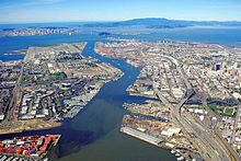
奥克兰有着全国第五大的貨櫃碼頭,也是重要的铁路枢纽。[145]在研究方面,NASA的埃姆斯研究中心坐落在山景城,而联邦政府的劳伦斯利佛摩国家实验室则坐落在利佛摩。在北湾的葡萄产区,则有Fantesca Estate & Winery、Domaine Chandon California和D'Agostini Winery这三个著名的酒厂。[146]
住房问题
湾区是全国居住成本最高的地区之一。经济的高速发展带来了大量的就业机会,同时也极大地限制了新居住用建筑的建设,[147]造成了严重的住房供应短缺。在2012-2017年间,旧金山都会区增加了40万个新岗位,却只增加了6万个新的居住单元[148]。在2016年,全湾区共有360万个岗位,却只有260万个住房单元,岗位和住房的比例达到了1.4:1[149],远远高出全国总体的水平(1.52亿个岗位比1.36亿个住房单位,大约是1.1:1)[150][151]。根据美国人口调查局2013年的统计,湾区有着最高的“房屋价值、月房贷和毛租金中位数”。[152][153]而到了2017年,湾区房价的中位数和平均数分别是89.5万美元和44万美元。有能力购买一套房子的居民,他们的收入的平均值达到了17.9万美元,是全国平均水平的两倍有余。另外,湾区的月租金也达到了1250美元,高于全国平均一半。[154].[155] 居高不下的居住成本,使得湾区的居民不得不将大量的收入投入住房中。其中,20%的居民在住房上的开支,还有25%的租客在租金的开支超过了收入的一半,[156]湾区的居民每年的居住开支大约是4.1万美元,其中在住房上的开支是2.8万美元,交通上的花费大约1.34万美元。大约59%居民的开支中位数达到了这个标准。[156]
高昂的居住成本也导致了大量流浪者的出现。[157]由于流浪者难以追踪,目前没有准确的数量[157],仅有的只是旧金山公共卫生局的统计:他们认为仅旧金山市内的流浪者就有9975人[158]。另外,旧金山也是全国流浪者数量最多的城市[158]。
不少在湾区工作的人都选择在偏远的位置买房,这也导致了湾区成为全国极限通勤者最多的地区:这些人通勤时间通常都在90分钟以上。例如,每天大约有5万人从邻县圣华金县进入湾区9县[159]。更夸张的是,有些人甚至通过飞机通勤[160]。
文化
艺术
音樂
- 參見主條目:灣區鞭擊金屬
在1980年代和1990年代初期,舊金山灣區是世界上影響力最大的鞭擊金屬發展區,知名的樂團包括金屬製品(雖然金屬製品是1981年底在洛杉磯成立的,但他們為了爭取貝斯手克利夫·伯頓點頭加入,便在1983年2月15日配合他的要求搬到舊金山灣區)、出埃及、爆衝火箭、死亡天使、極惡暴徒、禁令樂團和聖約[161]。
灣區還形成了許多死亡金屬樂團,例如附魔者(被認為是世上第一支死亡金屬樂團)[162]、驗屍人,以及90年代成立的刺穿樂團、掘屍樂團和惡魔樂團。
戏剧
媒体
體育
棒球
籃球
冰上曲棍球
橄榄球
教育
初级教育
高等教育
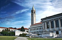
由USNEWS发布的排名中,加州的多所大学都名列前茅。其中,排名最高的是史丹佛大學,也是全美排名第五的大学。加州大学伯克利分校在全国的排名是20多,在过去的20年里,也是全美排名最高的公立大学。另外,圣何塞州立大学和索諾馬州立大學在西海岸的公立学院中排名第6和第12。[167]
旧金山市内还有两所大学,不过只提供研究生教育。其中,加利福尼亚大学旧金山分校致力于健康和生物医药,是全美排名第五的医学院[168]。同时,旧金山分校还有自己的医疗中心,还是全美最好的医院。[169]加利福尼亚大学哈斯汀法学院于1878年,在市政中心成立,是加州最老的法学院。另外加州的诸多法官里,毕业自此学院的最多。[170]另有加利福尼亞州立大學和旧金山州立大学也坐落于此。[171]加利福尼亚州社区大学系统在湾区也有着不少社区大学。根据CNN财经频道的报导,“成功率”最高的社区大学是德安扎学院,位于庫比蒂諾,在全国排名第10。另有一些排名较高的学院,例如山脚学院、旧金山城市学院、西谷大学、代阿布洛谷学院和拉斯波兹塔学院。[172]
很多学者都指出,湾区经济繁荣离不开较高的受教育程度。多篇报导都指出,斯坦福、加州大学圣克鲁兹分校和伯克利分校这样的研究型大学促进了湾区文化和经济的发展。[173] 这些大学还提供无数的公开课,使观众能提高促进当地经济的技能。这些机遇不仅为周边社区提供了教育,还带来了大量的收入。[173]參見
参考文献
- ^ Square Mileage by County. California States Association of Counties. [September 21, 2017].
- ^ Hinrichs, Scott. Mt. Hamilton Lick Observatory. September 28, 2006 [September 21, 2017].
- ^ Kurhi, Eric. San Jose: Overwhelmed pumps led to Alviso flooding; residents say it's a 'wake-up call'. San Jose Mercury News. December 11, 2014 [September 21, 2017].
- ^ Counties Population Totals Tables: 2010–2017. United States Census Bureau, Population Division. March 2018 [March 22, 2017].
- ^ Metropolitan and Micropolitan Statistical Area Population Totals Tables: 2010–2017. United States Census Bureau, Population Division. March 2018 [March 22, 2018].
- ^ Area Code Map for Northern California/Bay Area. White Pages. [September 21, 2017].
- ^ Demographia. Demographia World Urban Areas (PDF) 12th. April 2016 [November 17, 2016].
- ^ Demographia. Demographia World Urban Areas (PDF) 12th. April 2016 [November 17, 2016].
- ^ Walker, Richard and Alex Schafran. The strange case of the Bay Area (PDF). Environment and Planning. 2015, 47: 11–13.
- ^ The Nine Regional Water Quality Control Boards in California (PDF). California Water Boards. [September 18, 2017].
- ^ About the Air District. Bay Area Air Quality Management District. [September 18, 2017].
- ^ Welcome page. San Francisco Bay Restoration Authority. [September 18, 2017].
- ^ Nine Bay Area counties. Metropolitan Transportation Commission. [September 18, 2017].
- ^ ABAG Members. Association of Bay Area Governments. [September 18, 2017].
- ^ Bay Area Census – Counties. Bay Area Census. [September 18, 2017].
- ^ OMB Bulletin No. 13-01: Revised Delineations of Metropolitan Statistical Areas, Micropolitan Statistical Areas, and Combined Statistical Areas, and Guidance on Uses of the Delineations of These Areas (PDF). United States Office of Management and Budget. February 28, 2013 [April 17, 2013].
- ^ San Francisco-San Jose-Oakland Designated Media Market Data. Truck Ads. [September 18, 2017].
- ^ Crawford, Sabrina. Newcomer's Handbook for Moving to And Living in the San Francisco Bay Area: Including San Jose, Oakland, Berkeley, And Palo Alto. First Books. January 31, 2006: 9–182 [February 9, 2013]. ISBN 978-0-912301-63-1.
- ^ Nolte, Carl. Peninsula a surprise find south of S.F.. San Francisco Chronicle. November 7, 2015 [September 18, 2017].
- ^ Crawford, Sabrina. Newcomer's Handbook for Moving to And Living in the San Francisco Bay Area: Including San Jose, Oakland, Berkeley, And Palo Alto. First Books. January 31, 2006: 78–98 [February 9, 2013]. ISBN 978-0-912301-63-1.
- ^ Crawford, Sabrina. Newcomer's Handbook for Moving to And Living in the San Francisco Bay Area: Including San Jose, Oakland, Berkeley, And Palo Alto. First Books. January 31, 2006: 99–129 [February 9, 2013]. ISBN 978-0-912301-63-1.
- ^ Crawford, Sabrina. Newcomer's Handbook for Moving to And Living in the San Francisco Bay Area: Including San Jose, Oakland, Berkeley, And Palo Alto. First Books. January 31, 2006: 130–156 [February 9, 2013]. ISBN 978-0-912301-63-1.
- ^ San Jose Population 2018 (Demographics, Maps, Graphs). worldpopulationreview.com. [2018-02-11].
- ^ Crawford, Sabrina. Newcomer's Handbook for Moving to And Living in the San Francisco Bay Area: Including San Jose, Oakland, Berkeley, And Palo Alto. First Books. January 31, 2006: 157–182 [February 9, 2013]. ISBN 978-0-912301-63-1.
- ^ 25.0 25.1 Climate of San Francisco. Golden Gate Weather Services. 2009 [September 19, 2017].
- ^ 26.0 26.1 26.2 Miller, Miguel. Climate of San Jose. National Weather Service. April 1999 [September 19, 2017].
- ^ 27.0 27.1 Gilliam, Harold. Cutting Through the Fog: Demystifying the Summer Spectacle. Bay Nature. July–September 2002.
- ^ 28.0 28.1 28.2 Gillam, Harold. Weather as varied as the people / Land and fog build summer microclimates. San Francisco Chronicle. July 9, 2001 [September 19, 2001].
- ^ 引用错误:没有为名为
SFG climate2的参考文献提供内容 - ^ Gillam, Harold. Weather as varied as the people / Land and fog build summer microclimates. San Francisco Chronicle. July 9, 2001 [September 19, 2001].
- ^ Template:WRCC/type.pl?ca2934 Fairfield, California. Template:WRCC/name. Western Regional Climate Center (WRCC), National Oceanic and Atmospheric Administration (NOAA).
- ^ Template:WRCC/type.pl?ca6336 Oakland, California. Template:WRCC/name. Western Regional Climate Center (WRCC), National Oceanic and Atmospheric Administration (NOAA).
- ^ Template:WRCC/type.pl?ca7772 San Francisco Downtown, California. Template:WRCC/name. Western Regional Climate Center (WRCC), National Oceanic and Atmospheric Administration (NOAA).
- ^ Template:WRCC/type.pl?ca7821 San Jose. Template:WRCC/name. Western Regional Climate Center (WRCC), National Oceanic and Atmospheric Administration (NOAA).
- ^ Template:WRCC/type.pl?ca7965 Santa Rosa, California. Template:WRCC/name. Western Regional Climate Center (WRCC), National Oceanic and Atmospheric Administration (NOAA).
- ^ San Francisco Bay Area and Delta Protection. Center for Biological Diversity. [September 19, 2017].
- ^ Current California Ocean Recreational Fishing Regulations. California Department of Fish and Wildlife. [September 19, 2017].
- ^ From Salt Production to Salt Marsh. NASA Earth Observatory. February 11, 2016 [September 19, 2017].
- ^ Reiter, Matthew E. et al.,. A Monitoring Plan for Wintering Shorebids in the San Francisco Bay (PDF). California Landscape Conservation Cooperative. April 2011 [September 19, 2017].
- ^ Threatened and Endangered species. South Bay Restoration Project. [September 19, 2017].
- ^ Central California Coast Steelhead DPS (报告). NOAA's National Marine Fisheries Service Northwest Regional Office. [February 15, 2010].
- ^ Greg Miller. In Central California, Coho Salmon Are on the Brink. Science. January 2010, 327 (5965): 512–3 [Feb 15, 2010]. PMID 20110475. doi:10.1126/science.327.5965.512.
- ^ Conaway CH; Black FJ; Grieb TM; Roy S; Flegal AR. Mercury in the San Francisco Estuary. Rev Environ Contam Toxicol. Reviews of Environmental Contamination and Toxicology. 2008, 194: 29–54. ISBN 978-0-387-74815-3. PMID 18069645. doi:10.1007/978-0-387-74816-0_2.
- ^ Skinner, John E. An Historical Review of the Fish and Wildlife Resources of the San Francisco Bay Area (The Mammalian Resources). California Department of Fish and Game, Water Projects Branch Report no. 1. Sacramento, California: California Department of Fish and Game. 1962. (原始内容存档于July 26, 2011).
- ^ Suzanne Stewart and Adrian Praetzellis. Archeological Research Issues for the Point Reyes National Seashore – Golden Gate National Recreation Area (PDF) (报告). Anthropological Studies Center, Sonoma State University: 335. November 2003 [January 10, 2010].
- ^ Clark, Samantha. Leave it to beavers: California joins other states in embracing the rodent. San Jose Mercury News. August 12, 2016 [September 19, 2017].
- ^ Get Outside!. San Francisco Chronicle. April 1966 [March 6, 2011]. (原始内容存档于June 30, 2009).
- ^ Blue Oak Ranch Reserve. University of California. [March 6, 2011]. (原始内容存档于May 12, 2011). 已忽略未知参数
|df=(帮助) - ^ Sea Lions and the Sea Lion Story. Pier 39. [September 19, 2017].
- ^ Tokuda, Wendy; Hall, Richard; Wakiyama, Hanako (ill.). Humphrey the lost whale: a true story. Union City, California: Heian Intl Publishing Company. 1986. ISBN 0-89346-270-5. OCLC 779021889.
- ^ Roger, AnnaMarie. Dolphins and Porpoises in San Francisco Bay. Our Sausalito. [September 21, 2017].
- ^ Billiter, Bill. 3,000-Year-Old Connection Claimed : Siberia Tie to California Tribes Cited. Los Angeles Times (Los Angeles). January 1, 1985 [September 22, 2017]. (原始内容存档于November 28, 2014).
- ^ Stewart, Suzanne B. Archaeological Research Issues For The Point Reyes National Seashore – Golden Gate National Recreation Area (PDF). Sonoma State University – Anthropological Studies Center: 11. November 2003 [September 22, 2017].
- ^ Billiter, Bill. 3,000-Year-Old Connection Claimed : Siberia Tie to California Tribes Cited. Los Angeles Times (Los Angeles). January 1, 1985 [September 22, 2017]. (原始内容存档于November 28, 2014).
- ^ Visitors: San Francisco Historical Information. City and County of San Francisco. [June 10, 2008]. (原始内容存档于March 1, 2006).
- ^ 56.0 56.1 56.2 Visitors: San Francisco Historical Information. City and County of San Francisco. [June 10, 2008]. (原始内容存档于March 1, 2006).
- ^ Moraga Explores The Valley (PDF). Cagen Web. [September 22, 2017].
- ^ 58.0 58.1 Introduction. Early History of the California Coast. National Park Service. [September 22, 2017].
- ^ Lee Foster. Northern California History Weekends. Globe Pequot. October 1, 2001: 13 [December 26, 2011]. ISBN 978-0-7627-1076-8.
- ^ 60.0 60.1 The Virtual Museum of the City of San Francisco. From the 1820s to the Gold Rush. The Virtual Museum of the City of San Francisco. July 16, 2004 [September 22, 2017]. (原始内容存档于October 22, 2009).
- ^ The Virtual Museum of the City of San Francisco. From the 1820s to the Gold Rush. The Virtual Museum of the City of San Francisco. July 16, 2004 [September 22, 2017]. (原始内容存档于October 22, 2009).
- ^ Barkan, Elliott. Immigrants in American History: Arrival, Adaptation, and Integration. Santa Barbara: ABC-CLIO. 2013. ISBN 9781598842197.
- ^ Harris, Ron. Crews Unearth Shipwreck on San Francisco Condo Project. Associated Press. November 14, 2005 [September 22, 2017].
- ^ Castillo, Edward D. Short Overview of California Indian History. California Native American Heritage Commission. [October 9, 2017]. (原始内容存档于March 4, 2010).
- ^ Wilson, Dotson; Ebbert, Brian S. California's Legislature (PDF) 2006. Sacramento: California State Assembly. 2006: 149–154. OCLC 70700867.
- ^ Historical Census Statistics On Population Totals By Race, 1790 to 1990, and By Hispanic Origin, 1970 to 1990, For Large Cities And Other Urban Places In The United States. U.S. Census Bureau. [December 18, 2011]. (原始内容存档于August 6, 2012).
- ^ The Transcontinental Railroad: Transforing California and the Nation. UC Davis. [September 22, 2017].
- ^ The Great 1906 San Francisco Earthquake. United States Geological Survey. [September 24, 2017].
- ^ Casualties and damage after the 1906 Earthquake. United States Geological Survey. [September 24, 2017].
- ^ 70.0 70.1 Rodgers, Paul. Ripples from 1906 San Francisco quake felt even today. The Seattle Times. April 15, 2006 [September 24, 2017].
- ^ San Francisco Gold Rush Banking – 1849. The Virtual Museum of the City of San Francisco. June 24, 2004 [September 24, 2017].
- ^ Standen, Amy. 75 Years Ago, A Deadly Day On The Golden Gate. National Public Radio. May 27, 2012 [September 24, 2017].
- ^ Vorderbrueggen, Lisa. Building the Bay Bridge: 1930s vs. today. San Jose Mercury News. August 9, 2013 [September 24, 2017].
- ^ 74.0 74.1 Nolte, Carl. World War II reshaped the Bay Area and its people. San Francisco Chronicle. May 28, 2012 [September 24, 2017].
- ^ U.N. Charter signed. History Channel. [September 24, 2017].
- ^ Treaty of Peace with Japan (with two declarations). Signed at San Francisco, on 8 September 1951 (PDF). United Nations. September 8, 1951 [September 24, 2017].
- ^ 77.0 77.1 Ashbolt, Anthony. A Cultural History of the Radical Sixties in the San Francisco Bay Area. Routledge. 2013: 4.
- ^ Scott McKenzie, 1960s counter-culture singer, dies at 73. The Daily Telegraph. August 20, 2012 [September 24, 2017].
- ^ Robertson, Mark. Looking Back: Canning in the Valley of Heart's Delight. San Jose Public Library. [September 24, 2017].
- ^ Nolte, Carl. World War II reshaped the Bay Area and its people. San Francisco Chronicle. May 28, 2012 [September 24, 2017].
- ^ Shockley Semiconductor. Public Broadcasting Station. [September 24, 2017].
- ^ The New York Times. The California Quake: The Bay Bridge; Damage to Link Across Bay Is More Serious Than Thought. The New York Times. October 20, 1989.
- ^ 1990 and 1980 Census Counts for Cities with 1990 Population Greater Than 100,000. United States Census Bureau. [August 8, 2014].
1980: San Francisco = 678974, San Jose = 629400. 1990: San Jose = 782248, San Francisco = 723959
- ^ Clark, Tara. When Did The Stock Market Crash? A List Of U.S. Markets’ Worst Declines. ETF Daily News. May 13, 2015 [September 24, 2017].
- ^ 85.0 85.1 Bay Area Census – Bay Area Data. Bayareacensus.ca.gov. [November 4, 2011].
- ^ Gays rush to San Francisco to wed. BBC News. February 15, 2004 [October 1, 2014].
- ^ Wildermuth, John. Voters backing same-sex marriage ban. San Francisco Chronicle. November 5, 2008 [October 9, 2017].
- ^ Jones, Carolyn. Oakland storekeepers tell of night of terror. San Francisco Chronicle. January 9, 2009 [January 10, 2009]. (原始内容存档于January 16, 2009). 已忽略未知参数
|df=(帮助) - ^ Occupy Oakland: The Oscar Grant / Frank Ogawa Plaza Issue. San Francisco Chronicle. October 30, 2011 [October 9, 2017].
- ^ Sulek, Julia Prodis, Lisa M. Krieger, and Tatiana Sanchez. Women’s March: Huge Bay Area turnout as California resistance takes hold. San Jose Mercury News. January 22, 2017 [October 9, 2017].
- ^ McPhate, Mike. California Today: Bay Area Athletes Clash With Trump. The New York Times. September 25, 2017 [October 9, 2017].
- ^ Barmann, Jay. Bay Area Residents React To Trump Killing 'Dreamers' Program, Protests Planned. SFist. September 5, 2017 [October 9, 2017]. (原始内容存档于October 13, 2017). 已忽略未知参数
|df=(帮助) - ^ POPANERS: 2010–2017. United States Census Bureau, Population Division. March 2018 [March 22, 2018].
- ^ Bay Area Census – Bay Area Data. Bayareacensus.ca.gov. [November 4, 2011].
- ^ U.S. Immigrant Population by State and County. migrationpolicy.org. February 4, 2014 [July 6, 2017] (英语).
- ^ Census 2010: Table 3A – Total Population by Race (Hispanic exclusive) and Hispanic or Latino: 2010. California Department of Finance. [June 11, 2010]. (原始内容 (Excel)存档于November 24, 2011).
- ^ Willet, Megan. The Most Diverse Cities in United States. Business Insider. July 8, 2013 [September 11, 2014]. 参数
|magazine=与模板{{cite journal}}不匹配(建议改用{{cite magazine}}或|journal=) (帮助) - ^ 98.0 98.1 Bay Area Census – Bay Area Data. Bayareacensus.ca.gov. [November 4, 2011].
- ^ Judaism (estimated) Metro Areas (2000). The Association of Religion Data Archives. [December 1, 2009]. (原始内容存档于November 23, 2009).
- ^ Sanchez, Tatiana. Report: Bay Area Latino population growth has slowed. San Jose Mercury News. September 6, 2016 [September 19, 2017].
- ^ DelVecchio, Rick. Hispanics move from S.F., San Jose into suburbs / Numbers climb fast throughout state. San Francisco Chronicle. May 24, 2001 [September 19, 2017].
- ^ The Mission – A Barrio of Many Colors. KQED. [September 19, 2017].
- ^ Fagan, Mark. Asian population swells in Bay Area, state, nation. San Francisco Chronicle. March 22, 2012 [September 18, 2017].
- ^ The Asian Population: 2010 (PDF). U.S. Census: 12–13. [September 19, 2017].
- ^ QT-P3 – Race and Hispanic or Latino Origin: 2010. 2010 United States Census Summary File 1. United States Census Bureau. [July 11, 2011].
- ^ Indian-American population is fastest-growing minority group. East Bay Times. May 12, 2011 [September 19, 2017].
- ^ Training and Education /PET. Filipino-American Law Enforcement Officers Association. [April 28, 2012]. (原始内容存档于January 16, 2013).
- ^ Estrella, Cicero A. S.F.'s 'Little Saigon' / Stretch of Larkin Street named for Vietnamese Americans. San Francisco Chronicle. February 2004 [March 6, 2010].
- ^ Asian American Maps. Pew Research. [September 19, 2017].
- ^ Eaton, Joe and Ron Sullivan. Taste of Laos in Richmond school garden. San Francisco Chronicle. May 31, 2014 [September 19, 2017].
- ^ East Palo Alto. Bay Area Census. [September 19, 2017].
- ^ Fuller, Thomas. The Loneliness of Being Black in San Francisco. The New York Times. July 20, 2016 [September 18, 2017].
- ^ South Park, Santa Rosa's vibrant, ever-changing corner. The Press Democrat. [July 8, 2011].
- ^ Vallejo. Bay Area Census. [September 19, 2017].
- ^ Richmond. Bay Area Census. [September 19, 2017].
- ^ East Palo Alto. Bay Area Census. [September 19, 2017].
- ^ Community Facts. (2010, October 5). [United States Census Bureau]. Retrieved from factfinder.census.gov/faces/nav/jsf/pages/community_facts.xhtml#.
- ^ Scott, W. Richard, and Michael W. Krist. Higher Education and Silicon Valley: Connected but Conflicted. Johns Hopkins University Press, 2017.
- ^ Pleasanton tops county in median household income. Inside Bay Area. [October 15, 2006]. (原始内容存档于June 6, 2011).
- ^ 120.0 120.1 Levin, Matt. California’s rich-poor gap: The reality may surprise you. CalMatters. August 11, 2016 [October 9, 2017].
- ^ Holmes, Natalie and Alan Berube. City and metropolitan inequality on the rise, driven by declining incomes. Brookings Institution. January 14, 2016 [October 9, 2017].
- ^ DeBare, Ilana. 47 Bay Area billionaires on Forbes list. The San Francisco Chronicle. March 6, 2008.
- ^ Capgemini Announces 2010 U.S. Metro Wealth Index. Business Wire. August 3, 2010 [November 4, 2011].
- ^ Sernoffsky , Evan and Kurtis Alexander. U.S. crime drops again, but gains uneven in Bay Area. San Francisco Chronicle. September 28, 2015 [September 20, 2017].
- ^ Veklerov, Kimberly. FBI report reveals safest and most dangerous Bay Area cities. San Francisco Chronicle. September 28, 2016 [September 20, 2017].
- ^ 引用错误:没有为名为
uneven2的参考文献提供内容 - ^ Salonga, Robert. San Jose: Street violence rises, burglary drops in scattered crime profile for 2016. San Jose Mercury News. December 31, 2016 [September 20, 2017].
- ^ Oakland Boosts 'Operation Ceasefire' After Baby, Father Killed « CBS San Francisco. Sanfrancisco.cbslocal.com. August 8, 2013 [August 8, 2013].
- ^ California Department of Transportation. Metropolitan Transportation Commission. [September 18, 2017].
- ^ Amin, Ratna and Sara Barz. Seamless Transit (PDF). SPUR: 4–9. April 2015 [September 18, 2017].
- ^ Reed, Ted. All Three Bay Area Airports Grow as United Expands Frisco Hub and Oakland Gets Two Spain Flights. TheStreet. June 12, 2017 [September 18, 2017].
- ^ About the Trail. San Francisco Bay Trail. [September 18, 2017].
- ^ Cabanatuan, Michael. SF traffic ranks as 4th worst in world. San Francisco Chronicle. February 27, 2017 [September 18, 2017].
- ^ Atkins, Martin. San Francisco's Freeway Revolt. September 9, 2012 [September 18, 2017].
- ^ 11 Most Endangered: San Francisco Embarcadero | National Trust for Historic Preservation. savingplaces.org. [October 8, 2016].
- ^ California Road Atlas (地图). Thomas Brothers. 2009.
- ^ About Amtrak California. Amtrak. [September 20, 2017].
- ^ 引用错误:没有为名为
seamlesstransit2的参考文献提供内容 - ^ 引用错误:没有为名为
walker2的参考文献提供内容 - ^ Walker, Richard and Alex Schafran. The strange case of the Bay Area (PDF). Environment and Planning. 2015, 47: 14.
- ^ Analysis, US Department of Commerce, BEA, Bureau of Economic. Bureau of Economic Analysis (PDF). www.bea.gov. September 20, 2017 [January 29, 2018] (美国英语).
- ^ Bay Area GDP Watch 2016. September 2017 [January 29, 2018].
- ^ Fortune 500. Fortune. [September 20, 2017].
- ^ Downey, Rosie. Largest Bay Area manufacturers. American City Business Journals. August 4, 2017 [October 6, 2017].
- ^ North American Container Traffic, 2009 Port Ranking (PDF). [August 11, 2010].
- ^ Kester, Jennifer. Your Top California Wine-Tasting Itinerary: Napa and Sonoma. Forbes. [September 20, 2017].
- ^ Torres, Blanca. Housing’s tale of two cities: Seattle builds, S.F. lags. San Francisco Business Times. April 28, 2017 [December 4, 2017]. (原始内容存档于May 2, 2017).
So how can smaller Seattle make so much more housing happen than San Francisco? Developers active in both cities and officials who have worked in both point to structural differences that outweigh the demographic similarities. In San Francisco, development issues are routinely subject to consideration by neighborhood bodies, approval by the city planning commission and often ratification by its board of supervisors, with opportunities for decisions to be appealed. Seattle’s approval process is much more streamlined...The city’s planning commission is strictly a policy entity. It does not approve or reject projects. The city council weighs in on projects only in rare cases. [In S.F.]...he thinks that the California Environmental Quality Act, known as CEQA, makes it too easy for residents to sue projects, effectively holding them up for years or blocking them.
- ^ Clark, Patrick. Why Can’t They Build More Homes Where the Jobs Are?. Bloomberg. June 23, 2017 [December 1, 2017]. (原始内容存档于August 28, 2017).
San Francisco's metropolitan area added 373,000 net new jobs in the last five years—but issued permits for only 58,000 units of new housing. The lack of new construction has exacerbated housing costs in the Bay Area, making the San Francisco metro among the cruelest markets in the U.S. Over the same period, Houston added 346,000 jobs and permitted 260,000 new dwellings, five times as many units per new job as San Francisco.
- ^ Lucas, Scott. We found which Bay Area cities aren't pulling their weight on housing. Vox Media. October 12, 2016 [December 1,2017]. (原始内容存档于November 2, 2016).
- ^ Labor Force Statistics from the Current Population Survey (报告). United States Department of Labor - Bureau of Labor Statistics. November 4, 2017 [November 4, 2017].
- ^ Annual Estimates of Housing Units for the United States, Regions, Divisions, States, and Counties: April 1, 2010 to July 1, 2016 (报告). United States Census Bureau. July 1, 2016 [November 1, 2017].
- ^ Bee, C. A. (2013). The Geographic Concentration of High-Income Households: 2007-2011 (No. ACSBR/11-23). United States Census Bureau.
- ^ Bay Area burden. [electronic resource] : examining the costs and impacts of housing and transportation on Bay Area residents, their neighborhoods and the environment. (2009). Washington, DC : Urban Land Institute, c2009.
- ^ Alamo, C., Uhler, B., & O'Malley, M. (2015). California's high housing costs : causes and consequences. Sacramento, CA : Legislative Analyst's Office, March 17, 2015.
- ^ Scheinin, Richard. Bay Area real estate: To buy a median priced home, you now need income over $179,000. San Jose Mercury News. August 12, 2017 [September 20, 2017].
- ^ 156.0 156.1 Bay Area Burden. [Electronic Resource] : Examining the Costs and Impacts of Housing and Transportation on Bay Area Residents, Their Neighborhoods and the Environment. Washington, DC : Urban Land Institute, c2009., 2009. EBSCOhost
- ^ 157.0 157.1 Quigley, J. M., Raphael, S., & Smolensky, E. (2001). Homelessness in California. San Francisco, Calif. : Public Policy Institute of California, 2001.
- ^ 158.0 158.1 Suzuki, L. (2016, June 28). How Many People Live on Our Streets? San Francisco Chronicle. Retrieved from projects.sfchronicle.com/sf-homeless/numbers/.
- ^ Dougherty, Connor and Andrew Burton. A 2:15 Alarm, 2 Trains and aBus Get Her to Work by 7 A.M.. The New York Times. August 17, 2017 [September 20, 2017].
- ^ Bender, Kristen. Flying to work cheaper than living in the Bay Area for some. KTVU. December 25, 2017 [January 17, 2017].
- ^ What Is Thrash Metal?
- ^ allmusic ((( Seven Churches > Overview )))
- ^ About SCU – History. Santa Clara University. [October 19, 2017].
- ^ USF – Our History. University of San Francisco. [October 19, 2017].
- ^ San José State University: About SJSU: 1857–1879. San José State University. [October 29, 2013].
- ^ Cities with the Most College-Educated Residents. The New York Times. [September 20, 2017].
- ^ Bay Area universities rank among best in the US. ABC News. September 13, 2016 [September 20, 2017].
- ^ America's Best Graduate Schools: Best Medical Schools. U.S. News and World Report. 2010 [July 25, 2010]. (原始内容存档于April 21, 2010).
- ^ UCSF Medical Center in San Francisco. U.S. News and World Report. [July 25, 2010].
- ^ Hastings Quick Facts. University of California, Hastings College of the Law. [August 30, 2006].
- ^ SF State Fast Facts. SFSU. [September 21, 2017]. (原始内容存档于September 3, 2017). 已忽略未知参数
|df=(帮助) - ^ How does your community college stack up?. CNNMoney. [September 20, 2017].
- ^ 173.0 173.1 Scott, W. Richard, and Michael W. Krist. Higher Education and Silicon Valley: Connected but Conflicted. Johns Hopkins University Press, 2017.
| |||||||||||||||||||||||||||||||||||||||||||||||||


