
鹹海:修订间差异
→可能的環境問題解決方案: 修饰语句 维护清理 |
ThomasYehYeh(留言 | 贡献) 把我在2020年3月13日發表的翻譯重新校訂。除了把中文表達做順理之外,還把原來(鹹海流域計劃 簡稱為ASBP-1)各階段的冗長文字刪除。這篇文章應該是報導鹹海萎縮,以及產生問題為主的文章,在地理/歷史著墨的相對少一點。有關英文版中Ecology的部分,也是在我發表翻譯後加入,我作對應翻譯的不多。至於在平均深度/水體體積方面,有編譯要求引用來源,我找不到資料,留待網友協助。請指教。 标签:移除或更換文件 加入不可见字符 |
||
| 第1行: | 第1行: | ||
{{Expand English|Aral Sea}} |
{{Expand English|Aral Sea}} |
||
{{Infobox body of water |
{{Infobox body of water |
||
| name = 鹹海 |
|||
| native_name = |
|||
|image =AralSea1989 2014.jpg |
|||
| image = AralSea1989 2014.jpg |
|||
|caption = 鹹海於1989年及2014年照片 |
|||
| caption = 鹹海相片,1989年(左),2014年(右) |
|||
|image_bathymetry = |
|||
| image_bathymetry = |
|||
|caption_bathymetry = |
|||
| caption_bathymetry = |
|||
|location = {{KAZ}}<br />{{UZB}}<br />[[中亞]] |
|||
| location = [[哈薩克]]-[[烏茲別克]],<br>[[中亞]] |
|||
|coords = {{Coord|45|N|60|E|type:waterbody_scale:5000000|display=inline,title}} |
|||
| coords = {{Coord|45|N|60|E|type:waterbody_scale:5000000|display=inline,title}} |
|||
|type = [[内流盆地]]、天然湖泊、[[水庫]](北鹹海) |
|||
| type = [[內流盆地]]、天然[[湖泊]]、[[水庫]] (北方) |
|||
|inflow = 北鹹海:[[锡尔河]]<br />南鹹海:僅[[地表水]]<br />(曾为[[阿姆河]]) |
|||
| inflow = 北:[[錫爾河]]<br>南:僅[[地下水]]<br>(以前曾有[[阿姆河]]流入) |
|||
|outflow = |
|||
| outflow = |
|||
|catchment = {{Convert|1549000|km2|sqmi|-2}} |
|||
| catchment = {{Convert|1549000|km2|mi2|-2|abbr=on}} |
|||
|basin_countries = <small>{{KAZ}}<br />{{UZB}}<br />{{TKM}}<br />{{TAJ}}<br />{{AFG}} </small> |
|||
| basin_countries = {{Collapsible list|[[阿富汗]]<br>[[伊朗]]<br>[[哈薩克]]<br>[[吉爾吉斯]]<br>[[俄羅斯]]<br>[[塔吉克]]<br>[[土庫曼]]<br>[[烏茲別克]]}} <ref name=aral.unece.org/> |
|||
|length = |
|||
| length = |
|||
|width = |
|||
| width = |
|||
|area = {{Convert|17160|km2|sqmi|0}}<br />(2004年,共計4個湖泊)<br />{{Convert|28687|km2|sqmi|0}}<br />(1998年,共計2個湖泊)<br />{{Convert|68000|km2|sqmi|-2}}<br />(1960年,1個湖泊)<br />北鹹海:<br />{{Convert|3300|km2|sqmi|-1}}(2008年)<br />南鹹海:<br />{{Convert|3500|km2|sqmi|-1}}(2005年) |
|||
| area = {{Convert|68000|km2|mi2|-2|abbr=on}}<br>(1960年,一座完整湖泊)<br>{{Convert|28687|km2|mi2|0|abbr=on}}<br>(1998年,分成兩座湖泊)<br>'''{{Convert|17160|km2|mi2|0|abbr=on}}'''<br>'''(2004年,分成四座湖泊)'''<br>北:<br>{{Convert|3300|km2|mi2|-1|abbr=on}}(2008年)<br>南:<br>{{Convert|3500|km2|mi2|-1|abbr=on}}(2005年) |
|||
|depth = 北鹹海:{{Convert|8.7|m|ft|0}}(2007年)<br />南鹹海:{{Convert|14|m|ft|0}}(2005年) |
|||
| depth = 北:{{Convert|8.7|m|ft|0|abbr=on}}(2014年){{citation needed|date=July 2014}}<br>南: {{Convert|14|-|15|m|ft|0|abbr=on}}(2005年) |
|||
|max-depth = 北鹹海:<br />{{Convert|42|m|ft|0}}(2008年)<ref name="ENS wire">{{cite news |url=http://www.ens-newswire.com/ens/aug2008/2008-08-01-01.asp |title=The Kazakh Miracle: Recovery of the North Aral Sea |publisher=Environment News Service |date=2008-08-01 |accessdate=2010-03-22 |archive-url=https://web.archive.org/web/20100412135936/http://www.ens-newswire.com/ens/aug2008/2008-08-01-01.asp |archive-date=2010-04-12 |dead-url=no }}</ref><br />{{Convert|18|m|ft|0}}(2007年)<br />{{Convert|30|m|ft|0}}(2003年)<br />南鹹海:<br />{{Convert|37|m|ft|0}}(2005年)<br />{{Convert|102|m|ft|0}}(1989年) |
|||
| max-depth = 北:<br>{{convert|42|m|ft|0|abbr=on}}(2008年)<ref name="ENS wire">{{Cite news |
|||
|volume = 北鹹海:{{Convert|27|km3|mi3|0}}(2007年) |
|||
| |
| last = |
||
| |
| first = |
||
| title = The Kazakh Miracle: Recovery of the North Aral Sea |
|||
|elevation = 北鹹海:{{Convert|42|m|ft|0}}(2007年)<br />南鹹海:{{Convert|29|m|ft|0}}(2007年)<br />{{Convert|53.4|m|ft|0}}(1960年)<ref>[[JAXA]] - [http://www.eorc.jaxa.jp/en/imgdata/topics/2007/tp071226.html South Aral Sea shrinking but North Aral Sea expanding] {{Wayback|url=http://www.eorc.jaxa.jp/en/imgdata/topics/2007/tp071226.html |date=20111026100100 }}</ref> |
|||
| newspaper = Environment News Service |
|||
|islands = |
|||
| volume = |
|||
|cities =([[阿拉尔]]) |
|||
| issue = |
|||
| pages = |
|||
| date = 1 August 2008 |
|||
}}</ref><br>{{Convert|30|m|ft|0|abbr=on}} (2003年)<br>南:<br>{{Convert|37|-|40|m|ft|0|abbr=on}}(2005年)<br>{{convert|102|m|ft|0|abbr=on}}(1989年) |
|||
| volume = 北:{{Convert|27|km3|mi3|0|abbr=on}}(2007年){{citation needed|date=July 2014}} |
|||
| residence_time = |
|||
| shore = |
|||
| elevation = 北:{{Convert|42|m|ft|0|abbr=on}}(2011年)<br>南:{{Convert|29|m|ft|0|abbr=on}} (2007年)<br>{{Convert|53.4|m|ft|0|abbr=on}} (1960年)<ref>[[宇宙航空研究開發機構|日本太空署]] - [http://www.eorc.jaxa.jp/en/imgdata/topics/2007/tp071226.html South Aral Sea shrinking but North Aral Sea expanding]</ref> |
|||
| islands = |
|||
| cities = [[阿拉爾 (哈薩克斯坦)|阿拉爾]](哈薩克),[[木伊那克]](烏茲別克) |
|||
| pushpin_map = West Asia |
|||
}} |
}} |
||
[[File:Survey of the Sea of Aral 1853.jpg|thumb|right|刊於1853年倫敦[[皇家地理學會]]期刊中的鹹海地圖。]] |
|||
[[File:Aral Sea watershed.png|thumb|right|地圖:鹹海位置(約2008年海岸線)和周圍國家相關位置比較圖,阿姆河流域橘色,錫爾河黃色。]] |
|||
'''鹹海'''([[哈萨克语]]:'''{{rtl-lang|kk|Арал Теңізі}}''';[[乌兹别克语]]:'''{{lang|uz|Orol dengizi}}''';[[俄语]]:'''{{lang|ru|Аральскοе мοре}}'''),是[[中亞]]的一个[[内流湖|内流]][[鹹水湖]],位於[[哈薩克斯坦共和國]]和[[烏茲別克斯坦共和國]]的交界處。“咸海”意为“岛之海”,得名于曾分布于其中的超过1,100个岛屿。在[[突厥语族]]中,''aral''意为“岛或岛屿”。咸海的流域包括了[[乌兹别克斯坦]]全境及[[塔吉克斯坦]]、[[土库曼斯坦]]、[[吉尔吉斯斯坦]]、[[哈萨克斯坦]]、[[阿富汗]]和[[伊朗]]的部分地区。水源主要来自[[阿姆河]]和[[錫爾河]]。<ref>{{Cite web|url=https://www.unece.org/fileadmin/DAM/env/water/blanks/assessment/aral.pdf|title=DRAINAGE BASIN OF THE ARAL SEA AND OTHER TRANSBOUNDARY SURFACE WATERS IN CENTRAL ASIA|accessdate=4 Feb 2016|author=|date=|publisher=|archive-url=https://web.archive.org/web/20160206135431/https://www.unece.org/fileadmin/DAM/env/water/blanks/assessment/aral.pdf|archive-date=2016-02-06|dead-url=no}}</ref>咸海曾以68,000平方公里的面积名列世界第四大湖,但1960年代以后,由于[[苏联]]的引水灌溉的河道改道工程,導致咸海的面积不断地萎缩。到1997年,它已降至原始大小的10%,分成四個湖泊:[[北鹹海]],由曾經更大的{{link-en|南鹹海|South Aral Sea}}分成的東和西的兩個盆地湖,和一個較小的中間湖泊。<ref name="sciam">{{cite news|author1=Philip Micklin|author2=Nikolay V. Aladin|title=Reclaiming the Aral Sea|url=http://www.sciam.com/article.cfm?id=reclaiming-the-aral-sea&sc=rss|work=Scientific American|date=March 2008|accessdate=17 May 2008|archive-date=2019-12-11|archive-url=https://web.archive.org/web/20191211232101/http://www.sciam.com/article.cfm?id=reclaiming-the-aral-sea&sc=rss|dead-url=no}}</ref> |
|||
'''鹹海'''(Aral Sea,{{IPAc-en|ˈ|ær|əl}};<ref>{{Cite web |url=https://en.oxforddictionaries.com/definition/aral_sea |title = Aral Sea | Definition of Aral Sea in English by Lexico Dictionaries}}</ref> {{lang-kk|Aral teńizi, Арал теңізі}}, {{lang-uz|Orol dengizi, Орол денгизи}}, {{lang-kaa|Aral ten'izi, Арал теңизи}}, {{lang-ru|Аральское море}}),是[[中亞]]的一個[[内流盆地]](鹹水湖),在北方的[[哈薩克]]([[阿克托貝州]]和[[克孜勒奧爾達州]])和南方的[[烏茲別克]](其自治國[[卡拉卡爾帕克斯坦共和國]])的交界處,這座鹹水湖泊在2010年代已大致乾涸。鹹海在當地的名稱義為“島嶼之海”,名稱來自曾分布在海中超過1,100個的島嶼。在[[蒙古語系]]和[[突厥語族|突厥語系]]中,“aral”意為“島,或列島”。鹹海的[[流域]]包括[[烏茲別克]]全境,及[[塔吉克]]、[[土庫曼]]、[[吉爾吉斯]]、[[哈薩克]]、[[阿富汗]]、和[[伊朗]]的部分地區。<ref name=aral.unece.org>{{cite web|url=https://www.unece.org/fileadmin/DAM/env/water/blanks/assessment/aral.pdf|title=DRAINAGE BASIN OF THE ARAL SEA AND OTHER TRANSBOUNDARY SURFACE WATERS IN CENTRAL ASIA|website=United Nations Economic Commission for Europe (UNECE)|date= 2005|access-date= 4 February 2016}}</ref> |
|||
到2009年,東南方的湖消失,西南方的湖在原南鹹海的西部邊緣,退縮成一條細線。在隨後的幾年中,偶爾有少量水流補充東南方的湖。<ref>{{cite web|url= http://earthobservatory.nasa.gov/Features/WorldOfChange/aral_sea.php|title= Satellite image, August 16, 2009 (click on "2009" and later links)|date= 24 September 2014|accessdate= 2020-03-13|archive-date= 2009-05-21|archive-url= https://web.archive.org/web/20090521080850/http://earthobservatory.nasa.gov/Features/WorldOfChange/aral_sea.php|dead-url= no}}</ref>[[國家航空暨太空總署]]在2014年8月拍攝的衛星圖像顯示,鹹海東南部盆地在現代歷史上首次完全枯竭。<ref name="The Guardian 2014">{{cite news |last=Liston |first=Enjoli |url=https://www.theguardian.com/world/2014/oct/01/satellite-images-show-aral-sea-basin-completely-dried?CMP=fb_gu |title=Satellite images show Aral Sea basin 'completely dried' |work=The Guardian |location=London |publisher=Guardian News and Media Limited |date=1 October 2014 |accessdate=1 October 2014 |archive-date=2020-03-25 |archive-url=https://web.archive.org/web/20200325050103/https://www.theguardian.com/world/2014/oct/01/satellite-images-show-aral-sea-basin-completely-dried?CMP=fb_gu |dead-url=no }}</ref>這個盆地現在被稱為[[阿拉爾庫姆沙漠]]。 |
|||
鹹海曾以68,000平方公里的面積名列世界第四大湖,但1960年代以後,由於[[蘇聯]]引水灌溉,進行更改河道工程,導致鹹海面積不断萎缩。到1997年,已降至原始大小的10%,分成四個湖泊:[[北鹹海]]、由曾經更大的{{link-en|南鹹海|South Aral Sea}}分成的東和西的兩個盆地湖,加上一個較小的中間湖泊。<ref name="sciam">{{cite news|author1=Philip Micklin|author2=Nikolay V. Aladin|title=Reclaiming the Aral Sea|url=http://www.sciam.com/article.cfm?id=reclaiming-the-aral-sea&sc=rss|work=Scientific American|date=March 2008|accessdate=17 May 2008|archive-date=2019-12-11|archive-url=https://web.archive.org/web/20191211232101/http://www.sciam.com/article.cfm?id=reclaiming-the-aral-sea&sc=rss|dead-url=no}}</ref> |
|||
到2009年,東南方的小湖消失,西南方的湖在原南鹹海的西部邊緣,退縮成一條細線狀。在隨後幾年中,偶爾會有少量水流補充東南方的小湖。<ref>{{cite web|url= http://earthobservatory.nasa.gov/Features/WorldOfChange/aral_sea.php|title= Satellite image, August 16, 2009 (click on "2009" and later links)|date= 24 September 2014|accessdate= 2020-03-13|archive-date= 2009-05-21|archive-url= https://web.archive.org/web/20090521080850/http://earthobservatory.nasa.gov/Features/WorldOfChange/aral_sea.php|dead-url= no}}</ref>美國[[國家航空暨太空總署]]在2014年8月所拍攝的衛星圖像顯示,鹹海東南部盆地發生現代史上首次的完全枯竭,<ref name="The Guardian 2014">{{cite news |last=Liston |first=Enjoli |url=https://www.theguardian.com/world/2014/oct/01/satellite-images-show-aral-sea-basin-completely-dried?CMP=fb_gu |title=Satellite images show Aral Sea basin 'completely dried' |work=The Guardian |location=London |publisher=Guardian News and Media Limited |date=1 October 2014 |accessdate=1 October 2014 |archive-date=2020-03-25 |archive-url=https://web.archive.org/web/20200325050103/https://www.theguardian.com/world/2014/oct/01/satellite-images-show-aral-sea-basin-completely-dried?CMP=fb_gu |dead-url=no }}</ref>產生的盆地被稱為[[阿拉爾庫姆沙漠]]。 |
|||
哈薩克為保存和補充北鹹海而持續努力,於2005年完成{{link-en|科卡拉爾大壩|Dike Kokaral}}。與2003年相比,這裡的水位到2008年已上升12公尺(39英尺)。<ref>{{cite web |author1=Stephen M Bland |title=Central Asia Caucasus |url=https://www.stephenmbland.com/#!kazakhstan-measuring-the-northern-aral/cewp |website=stephenmbland.com |language=en |accessdate=2020-03-13 |archive-date=2017-11-15 |archive-url=https://web.archive.org/web/20171115123047/https://www.stephenmbland.com/#!kazakhstan-measuring-the-northern-aral/cewp |dead-url=no }}</ref>海水鹽度下降,魚類回復到足夠數量,讓某種程度的捕撈可行。<ref>{{cite web|url=http://www.aljazeera.com/programmes/earthrise/2012/07/201271912543306106.html|title=Aral Sea Reborn|publisher=Al Jazeera|date=21 July 2012|accessdate=6 January 2013|archive-date=2020-03-25|archive-url=https://web.archive.org/web/20200325050114/https://www.aljazeera.com/programmes/earthrise/2012/07/201271912543306106.html|dead-url=no}}</ref>截至2008年,北鹹海的最大深度為42公尺(138英尺)。<ref name="ENS wire"/> |
|||
鹹海的萎縮事件被稱為“地球上最嚴重的環境災難之一”。<ref>{{cite news|author=Daily Telegraph|title=Aral Sea 'one of the planet's worst environmental disasters'|url=https://www.telegraph.co.uk/earth/earthnews/7554679/Aral-Sea-one-of-the-planets-worst-environmental-disasters.html|date=5 April 2010|accessdate=1 May 2010|location=London|work=[[The Daily Telegraph]]|archiveurl=https://web.archive.org/web/20100408214552/http://www.telegraph.co.uk/earth/earthnews/7554679/Aral-Sea-one-of-the-planets-worst-environmental-disasters.html|archivedate=2010-04-08|dead-url=no}}</ref><ref name="about-aral-sea">{{cite web| url=https://www.people-travels.com/aral-sea-tours/| title=About travel to Aral Sea| accessdate=29 August 2016| archive-date=2020-03-10| archive-url=https://web.archive.org/web/20200310162033/https://www.people-travels.com/aral-sea-tours/| dead-url=no}}</ref>這個地區曾經繁榮過的漁業遭到破壞,造成失業和經濟困頓。被轉移的[[錫爾河]]河水用於灌溉[[費爾干納盆地]](Ferghana Valley)中約200萬公頃(500萬英畝)農田。<ref>{{cite web |title=Syr Darya river, Central Asia |url=https://www.britannica.com/place/Syr-Darya |website=Encyclopedia Britannica |language=en |accessdate=2020-03-13 |archive-date=2020-03-25 |archive-url=https://web.archive.org/web/20200325050129/https://www.britannica.com/place/Syr-Darya |dead-url=no }}</ref>鹹海地區受到嚴重污染,隨之而來的是嚴重的[[公共衛生]]問題。 |
|||
[[聯合國教育、科學與文化組織]]在其《[[世界記憶計劃]]》中增加有關鹹海這種歷經巨變的歷史文獻,作為研究這種“環境悲劇”的獨特資料來源。 |
|||
==鹹海形成== |
|||
[[阿姆河]]經由[[烏茲伯伊水道]]流入[[裏海]],直到[[全新世]],英籍地理學家{{link-en|尼克·米德爾頓|Nick Middleton}}認為,阿姆河從全新世開始才流入淺窪地而形成鹹海。<ref name="physical1">Middleton, Nick; "The Aral Sea" in Shahgedanova Maria; ''The Physical Geography of Northern Eurasia''; pp. 497-498</ref><ref>Velichko, Andrey and Spasskaya, Irina; "Climatic Change and the Development of Landscapes" in Shahgedanova Maria; ''The Physical Geography of Northern Eurasia''; pp. 48-50</ref> |
|||
==鹹海水中生物== |
|||
[[File:Ukrainian stickleback (Pungitius platygaster).jpg|thumb|{{le|烏克蘭棘魚|Ukrainian stickleback}}(Pungitius platygaster)是鹹海唯一本地種,經過鹹海萎縮以及鹽度大增後仍能存活者。]] |
|||
===本地魚類=== |
|||
雖然鹹海以前面積甚大,但其本地[[生物多樣性]]並不高。然而鹹海盆地有一系列魚類[[亞種]]的[[特有種]](包括三種[[鱘科]]特有種)。一些魚類如鱘科因為鹽度增加,或是湖面萎縮而導致滅絕。但相當多本地魚類因為北鹹海的水位自1990年代開始部分恢復而開始復育。<ref name=":1">{{Cite journal|last1=Aladin|first1=Nikolay Vasilevich|last2=Gontar|first2=Valentina Ivanovna|last3=Zhakova|first3=Ljubov Vasilevna|last4=Plotnikov|first4=Igor Svetozarovich|last5=Smurov|first5=Alexey Olegovich|last6=Rzymski|first6=Piotr|last7=Klimaszyk|first7=Piotr|date=2019|title=The zoocenosis of the Aral Sea: six decades of fast-paced change|journal=Environmental Science and Pollution Research International|volume=26|issue=3|pages=2228–2237|doi=10.1007/s11356-018-3807-z|issn=0944-1344|pmc=6338704|pmid=30484051}}</ref> |
|||
===無脊椎動物=== |
|||
[[File:Zebra mussel (8741971412).jpg|thumb|[[斑馬貽貝]]曾是鹹海大量的[[底棲生物]],現也重回[[北鹹海]]。 ]] |
|||
鹹海在萎縮之前有大約250種本地水生無脊椎動物,其中大部分(約80%)是[[淡水]]物種;其餘的是與裏海、地中海、大西洋動物群有關聯的{{le|海洋無脊椎動物|Marine invertebrates}}。當鹹海鹽度增加後,大部分淡水物種消失,殘餘的海洋無脊椎動物的存活將由日後海水鹽度的變化而定。<ref name=":1"/> |
|||
哈薩克斯坦為保存和補充北鹹海而持續不懈努力,於2005年完成{{link-en|戴克·科卡拉爾大壩|Dike Kokaral}}項目。與2003年相比,這裡的水位到2008年上升了12公尺(39英尺)。<ref>{{cite web |author1=Stephen M Bland |title=Central Asia Caucasus |url=https://www.stephenmbland.com/#!kazakhstan-measuring-the-northern-aral/cewp |website=stephenmbland.com |language=en |accessdate=2020-03-13 |archive-date=2017-11-15 |archive-url=https://web.archive.org/web/20171115123047/https://www.stephenmbland.com/#!kazakhstan-measuring-the-northern-aral/cewp |dead-url=no }}</ref>鹽度下降,魚類回復到足夠數量,讓某種程度的捕撈可行。<ref>{{cite web|url=http://www.aljazeera.com/programmes/earthrise/2012/07/201271912543306106.html|title=Aral Sea Reborn|publisher=Al Jazeera|date=21 July 2012|accessdate=6 January 2013|archive-date=2020-03-25|archive-url=https://web.archive.org/web/20200325050114/https://www.aljazeera.com/programmes/earthrise/2012/07/201271912543306106.html|dead-url=no}}</ref>截至2008年,北鹹海的最大深度為42公尺(138英尺)。<ref name="ENS wire"/> |
|||
鹹海的萎縮被稱為“地球上最嚴重的環境災難之一”。<ref>{{cite news|author=Daily Telegraph|title=Aral Sea 'one of the planet's worst environmental disasters'|url=https://www.telegraph.co.uk/earth/earthnews/7554679/Aral-Sea-one-of-the-planets-worst-environmental-disasters.html|date=5 April 2010|accessdate=1 May 2010|location=London|work=[[The Daily Telegraph]]|archiveurl=https://web.archive.org/web/20100408214552/http://www.telegraph.co.uk/earth/earthnews/7554679/Aral-Sea-one-of-the-planets-worst-environmental-disasters.html|archivedate=2010-04-08|dead-url=no}}</ref><ref name="about-aral-sea">{{cite web| url=https://www.people-travels.com/aral-sea-tours/| title=About travel to Aral Sea| accessdate=29 August 2016| archive-date=2020-03-10| archive-url=https://web.archive.org/web/20200310162033/https://www.people-travels.com/aral-sea-tours/| dead-url=no}}</ref>這個地區曾經繁榮過的漁業遭到破壞,造成失業和經濟困頓。被轉移的[[錫爾河]]河水用於灌溉[[費爾干納盆地]](Ferghana Valley)中約200萬公頃(500萬英畝)的農田。<ref>{{cite web |title=Syr Darya river, Central Asia |url=https://www.britannica.com/place/Syr-Darya |website=Encyclopedia Britannica |language=en |accessdate=2020-03-13 |archive-date=2020-03-25 |archive-url=https://web.archive.org/web/20200325050129/https://www.britannica.com/place/Syr-Darya |dead-url=no }}</ref>鹹海地區受到嚴重污染,隨之而來的是嚴重的公共衛生問題。 |
|||
[[聯合國教育、科學與文化組織]]在其《[[世界記憶計劃]]》中增加了有關鹹海這種歷經巨變的歷史文獻,作為研究這種“環境悲劇”的獨特材料來源。 |
|||
==鹹海的形成== |
|||
英籍地理學家{{link-en|尼克·米德爾頓|Nick Middleton}}認為,直到[[全新世]]開始,[[阿姆河]]才流入淺窪地而形成日後的鹹海,世人所知的,阿姆河到全新世經由[[烏茲伯伊水道]]流入[[裏海]]。在[[上新世]]期間,錫爾河在今日的[[克孜勒庫姆沙漠]]形成了一個大湖,稱為Mynbulak湖。<ref>Velichko, Andrey and Spasskaya, Irina; "Climatic Change and the Development of Landscapes" in Shahgedanova Maria; ''The Physical Geography of Northern Eurasia''; pp. 48-50</ref> |
|||
== 歷史 == |
== 歷史 == |
||
[[File:Тарас Шевченко Шхуни біля форту Косарал.jpg|thumb|[[俄羅斯帝國|帝俄]]時期最早配置在鹹海的船舶,由畫家[[塔拉斯·赫里霍羅維奇·謝甫琴科]]在1848年所繪。]] |
|||
鹹海周圍的大部分地區都由沙漠游牧民族所居住,他們很少留下書面記錄。但是,在南部的阿姆河三角洲有[[花剌子模帝國]],擁有悠久的歷史。它曾經是[[唐朝]]時期中國最西端的邊界。<ref name=Tang>{{cite book|last1=Gan|first1=Chunsong|title=A Concise Reader of Chinese Culture|year=2019|url=https://books.google.com.sg/books?id=RR2nDwAAQBAJ&pg=PA24&dq=aral+sea+tang+dynasty&hl=en&sa=X&ved=0ahUKEwin3oah3YrnAhXjheYKHSK-CcwQ6AEIOTAC#v=onepage&q=aral%20sea%20tang%20dynasty&f=false|access-date=2020-03-13|archive-date=2020-03-25|archive-url=https://web.archive.org/web/20200325050134/https://books.google.com.sg/books?id=RR2nDwAAQBAJ&pg=PA24&dq=aral+sea+tang+dynasty&hl=en&sa=X&ved=0ahUKEwin3oah3YrnAhXjheYKHSK-CcwQ6AEIOTAC#v=onepage&q=aral%20sea%20tang%20dynasty&f=false|dead-url=no}}</ref> |
|||
[[File:Survey of the Sea of Aral 1853.jpg|thumb|刊於1853年倫敦[[皇家地理學會]]期刊中的鹹海地圖。]] |
|||
[[File:唐朝疆域(简).png|缩略图|无]] |
|||
鹹海的水平面因為氣候變化而經歷多次的上升和下降。阿姆河和錫爾河的流入水量也受河流源頭冰川融化速度,以及流域內降水的影響,而寒冷乾燥的氣候也對前述的冰川融化和降水量產生限制。<ref name="Cretaux-pp-100">Cretaux et. al 2013, pp. 100, 105-106</ref>,從古持續至今的人工引水灌溉,也影響到鹹海的進水量。<ref>Cretaux et. al 2013, pp. 103</ref><ref>Boroffka 2010, pp. 295</ref> |
|||
鹹海曾經是[[中國]][[唐朝]]時期最西端的邊界。<ref name=“Tang”>{{cite book|last1=Li|first1=Shi|title=The History of Customs in Sui, Tang and Five Dynasties|year=2019|https://books.google.com.tw/books?id=jCOKDwAAQBAJ&pg=PT163&lpg=PT163&dq=The+Aral+Sea+was+part+of+the+western+frontier+of+the+Chinese+Empire+during+the+Tang+dynasty&source=bl&ots=QMLDZxoMxN&sig=ACfU3U37VRGBek4bHdSWSjmWJWmo6YDaRg&hl=zh-TW&sa=X&ved=2ahUKEwinuY3Qz5vxAhVIeXAKHbSnBRwQ6AEwGnoECA8QAw#v=onepage&q=The%20Aral%20Sea%20was%20part%20of%20the%20western%20frontier%20of%20the%20Chinese%20Empire%20during%20the%20Tang%20dynasty&f=false|page=|isbn=}}</ref><ref name=Tang>{{cite book|last1=Gan|first1=Chunsong|title=A Concise Reader of Chinese Culture|year=2019|url=https://books.google.com/books?id=RR2nDwAAQBAJ&q=aral+sea+tang+dynasty&pg=PA24|page=24|isbn=9789811388675}}</ref> |
|||
=== 鹹海海軍歷史 === |
=== 鹹海海軍歷史 === |
||
[[File:Michell-Russian-steam-barges-Kungrad.jpg|thumb|left|1850年代帝俄海軍,鹹海艦隊船舶。]] |
|||
[[File:Operational Navigation Chart F-5, 6th edition.jpg|thumb|left|鹹海及周圍區域地圖 ([[美國國家地理空間情報局]]所屬國防製圖處 (DMA)製作, 1979年)。]] |
|||
[[File:Operational Navigation Chart F-5, 6th edition.jpg|thumb|鹹海及周圍區域地圖 ([[美國國家地理空間情報局]]所屬國防製圖處(DMA)製作(1979年))。]] |
|||
[[File:Тарас Шевченко Шхуни біля форту Косарал.jpg|thumb|帝俄時期最早配置在鹹海的船舶,由畫家[[塔拉斯·赫里霍羅維奇·謝甫琴科]]在1848年所繪。]] |
|||
[[File:Michell-Russian-steam-barges-Kungrad.jpg|thumb|1850年代帝俄海軍,鹹海艦隊的船舶。]] |
|||
俄羅斯在鹹海的海軍部署始於1847年,在賴姆斯克(Raimsk)建立基地,隨後改名為阿拉爾斯克堡(Fort Aralsk),地點位於錫爾河河口附近。不久,[[俄羅斯帝國海軍]]開始在海上部署船舶。由於鹹海未與其他水域相連,因此必須在[[烏拉爾河]]上的[[奧倫堡]]將船隻拆解,透過陸路運至阿拉爾斯克堡(大約是透過{{link-en|駱駝商隊|camel train}})的錫爾河上重新組裝。 |
|||
1847年組裝的 |
俄羅斯在鹹海部署海軍,始於1847年,在位於錫爾河河口附近的賴姆斯克(Raimsk)建立基地(基地隨後改名為[[阿拉爾 (哈薩克斯坦)|阿拉爾]])。不久,[[俄羅斯帝國海軍|帝國海軍]]開始在鹹海上部署船舶。由於鹹海未與其他水域相連,因此必須在[[烏拉爾河]]上的[[奧倫堡]]將船隻拆解,透過陸路運至阿拉爾的錫爾河上重新組裝。1847年首先組裝的兩艘船是[[雙桅縱帆船]],船名是Nikolai和Mikhail。前者是艘軍艦;後者是艘商船,為海上建立的漁業提供服務。1848年,這兩艘船對鹹海北部進行勘測。同年,海軍又組裝一艘更大的軍艦,名為Constantine。由阿列克謝·巴塔科夫中尉(Lt. Alexey Butakov,Алексей Бутаков)指揮,Constantine在接下來兩年完成對整個鹹海的勘測。<ref name=michell>{{Cite book|first1= Chokan Chingisovich |last1=Valikhanov |first2= Mikhail Ivanovich |last2=Venyukov |publisher=Edward Stanford |location=London |year=1865 |title=The Russians in Central Asia: their occupation of the Kirghiz steppe and the line of the Syr-Daria: their political relations with Khiva, Bokhara, and Kokan: also descriptions of Chinese Turkestan and Dzungaria |others= Translated by John Michell, Robert Michell |url=https://archive.org/details/cu31924023159621 |pages=[https://archive.org/details/cu31924023159621/page/n349 324]–329}}</ref>受到帝俄流放到此的烏克蘭詩人和畫家[[塔拉斯·赫里霍羅維奇·謝甫琴科]]參與這次勘測,並為鹹海沿岸繪製一批素描。<ref>{{Cite book |
||
|first=David Alan |last=Rich|publisher=Harvard University Press|year=1998|isbn=0-674-91111-3|title=The Tsar's colonels: professionalism, strategy, and subversion in late Imperial Russia|url=https://books.google.com/?id=lF42jb5Fg4cC|page=247}}</ref> |
|first=David Alan |last=Rich|publisher=Harvard University Press|year=1998|isbn=0-674-91111-3|title=The Tsar's colonels: professionalism, strategy, and subversion in late Imperial Russia|url=https://books.google.com/?id=lF42jb5Fg4cC|page=247}}</ref> |
||
在1851年的航行季節中,兩艘新建的汽船從瑞典運抵,仍 |
在1851年的航行季節中,兩艘新建的汽船從瑞典運抵,仍由奧倫堡經由駱駝商隊運來後裝配。由於在地質調查中未發現當地有煤炭沉積,因此奧倫堡軍事總督{{link-en|瓦西里·佩羅夫斯基|Vasily Perovsky}}下令 “盡可能大量供應”[[梭梭]](Haloxylon ammodendron,類似於灌叢(creosote bush)的沙漠灌木),集中到阿拉爾,供這兩艘汽船作燃料使用。由於梭梭木不是一種合適的燃料,在後來的幾年中,鹹海的帝俄艦隊花費昂貴的成本從[[頓巴斯]]購入煤炭作為汽船的燃料。<ref name=michell/> |
||
=== 灌溉渠道 === |
=== 灌溉渠道 === |
||
{{ |
{{further|{{le|蘇聯自然改造大計劃|Great Plan for the Transformation of Nature}}}} |
||
[[File:Karakalpakstan Kyzyl Qala Cotton Picking.jpg|thumb|[[卡拉卡爾帕克斯坦共和國]],離{{le|克孜勒-卡拉|Kyzyl-Kala}}不遠處,當地人採收棉花。]] |
|||
[[File:Aral Sea.gif|The shrinking of the Aral Sea.|thumb|鹹海萎縮的時間軸。]] |
|||
[[File:Aral Sea.gif|The shrinking of the Aral Sea.|thumb|鹹海萎縮時間軸。]] |
|||
[[File:Shrinking Aral Sea 2000-2018.webm|thumb|left|衛星影像顯示鹹海水位,從2000年到2018年的變化。]] |
|||
在1960年代初期,[[蘇聯]]政府決定將兩條注入鹹海的河流 |
在1960年代初期,[[蘇聯]]政府決定將兩條注入鹹海的河流-南部的阿姆河和東部的錫爾河改道,用來灌溉沙漠,以種植[[水稻]]、甜瓜、穀物、和[[棉花]]。<ref name=ns>{{cite news|url=https://www.newscientist.com/article/mg12416910.800-soviet-cotton-threatens-a-regions-sea--and-its-children.html|title=Soviet cotton threatens a region's sea - and its children|date=18 November 1989|work=[[New Scientist]]|accessdate=27 January 2010|archive-date=2015-04-26|archive-url=https://web.archive.org/web/20150426170314/http://www.newscientist.com/article/mg12416910.800-soviet-cotton-threatens-a-regions-sea--and-its-children.html|dead-url=no}}</ref>這是蘇聯計劃讓棉花(“白金”)成為主要出口商品規劃中之一。這項工作很快就獲得成功,1988年,[[烏茲別克]]成為世界最大棉花出口國。<ref>{{cite web|author=USDA-Foreign Agriculture Service|title=Cotton Production Ranking|url=http://www.cotton.org/econ/cropinfo/cropdata/rankings.cfm|publisher=National Cotton Council of America|year=2013|accessdate=14 October 2013|archive-date=2019-04-20|archive-url=https://web.archive.org/web/20190420202909/http://www.cotton.org/econ/cropinfo/cropdata/rankings.cfm|dead-url=no}}</ref>{{link-en|烏茲別克棉花生產|Cotton production in Uzbekistan}}對該國的國民經濟(參考[[烏茲別克經濟]])仍然很重要。<ref name="guardian">{{cite news |title=Cotton production linked to images of the dried up Aral Sea basin |url=https://www.theguardian.com/sustainable-business/sustainable-fashion-blog/2014/oct/01/cotton-production-linked-to-images-of-the-dried-up-aral-sea-basin |work=The Guardian |date=1 October 2014 |accessdate=2020-03-13 |archive-date=2020-03-25 |archive-url=https://web.archive.org/web/20200325050154/https://www.theguardian.com/sustainable-business/sustainable-fashion-blog/2014/oct/01/cotton-production-linked-to-images-of-the-dried-up-aral-sea-basin |dead-url=no }}</ref><ref>{{cite web |title=The True Costs of Cotton: Cotton Production and Water Insecurity |url=https://ejfoundation.org/resources/downloads/EJF_Aral_report_cotton_net_ok.pdf |publisher=Environmental Justice Foundation (EJF) |accessdate=2020-03-13 |archive-date=2020-08-17 |archive-url=https://web.archive.org/web/20200817150731/https://ejfoundation.org/resources/downloads/EJF_Aral_report_cotton_net_ok.pdf |dead-url=no }}</ref>在2006年佔全國出口總值的17%。<ref>''Uzbekistan in Numbers 2006'', State Statistical Committee of the Republic of Uzbekistan, Tashkent, 2007 {{ru icon}}.</ref> |
||
當地從1940年代開始做大規模的灌溉渠道建設。許多渠道的建設品質很差,導致河水滲漏或者蒸發。從中亞最大的[[卡拉庫姆運河]]開始,大約有30%至75%的水被浪費掉。今天,烏茲別克斯坦的灌溉渠道之中,只有12%做了防水。在流域裡面47,750公里的農場間灌溉渠道中,只有28%的區域具有{{link-en|渠道防滲襯裡|Canal lining}}。只有77%的農場取水口裝有流量計(請參考{{link-en|流量測量|Flow measurement}}相關部分),在268,500公里的田間渠道中,只有21%的水渠有渠道防滲襯裡,有襯裡的渠道平均比沒有襯裡的可多保留15%的灌溉用水。<ref>{{cite news|url=http://www.cawater-info.net/aral/aral0_e.htm|title=ca-water.net, a knowledge base for projects in the Central Asia|year=2003|accessdate=1 November 2010|archive-date=2020-03-25|archive-url=https://web.archive.org/web/20200325050215/http://www.cawater-info.net/aral/aral0_e.htm|dead-url=no}}</ref> |
|||
當地從1930年代開始大規模建設灌溉渠道,到1960年代更把規模擴大。許多渠道的建設品質很差,導致河水滲漏或者蒸發。流經中亞規模最大的[[卡拉庫姆運河]]河水中,大約有30%至75%被浪費掉。迄2012年,烏茲別克的灌溉渠道之中,只有12%有做防水處理。在流域裡面長達47,750公里的農場間灌溉渠道中,只有28%的區域具有{{link-en|渠道防滲襯裡|Canal lining}}。只有77%的農場取水口裝有流量計。<ref>{{cite news|url= http://www.cawater-info.net/aral/aral0_e.htm|title=ca-water.net, a knowledge base for projects in the Central Asia|year=2003|access-date=1 November 2010}}</ref> |
|||
{{cn|到1960年,每年有20至60立方公里(4.8至14.4立方英里)的水流向陸地而不是鹹海。鹹海的大部分供水已被轉移,在1960年代,鹹海開始萎縮。從1961年到1970年,鹹海的水面平均每年下降20公厘(7.9英寸)。在1970年代,平均速率幾乎增加了兩倍,達到每年50-60公厘(20-24英寸),到1980年代,它繼續下降,現在平均每年80-90公厘(31-35英寸)。灌溉用水率繼續增加;在1960年至2000年期間,從河流中抽取的水量增加了一倍,而同期的棉花產量幾乎增加了一倍}}。 |
|||
在灌溉 |
到1960年,每年有20至60立方公里(4.8至14.4立方英里)的水流往陸地,而非鹹海,海面開始萎縮。從1961年到1970年,鹹海的水面平均每年下降20公厘(7.9英寸)。在1970年代,平均速率幾乎達到三倍,每年50-60公厘(20-24英寸),到1980年代,它繼續下降,平均每年下降80-90公厘(31-35英寸)。灌溉用水率繼續增加,在1960年至2000年期間,從河流中抽取的水量增加一倍。在20世紀上半葉灌溉發生之前,鹹海海平面海拔穩定維持在53公尺。到2010年,大鹹海海平面海拔為27公尺,小鹹海的海拔為43公尺。<ref>{{cite journal |last1=Micklin |first1=Philip |date=December 2017 |title=The past, present, and future Aral Sea |journal=Lakes & Reservoirs: Research & Management |volume=15 |issue=3 |pages=193–213|doi=10.1111/j.1440-1770.2010.00437.x }}</ref> |
||
對蘇聯人來說,湖水的消失並不稀奇。他們很早就預期這情況該會發生。早在1964年,在蘇聯{{link-en|水電項目研究所|Hydroproject}}任職的亞歷山大·阿薩林(Aleksandr Asarin)指出,這座鹹海注定要消失,並解釋說:“這是{{le|蘇聯政府|Government of the Soviet Union|政府}}和[[政治局]]批准的[[蘇聯五年計劃|五年計劃]]的一部分。縱然那與鹹海命運有關,下級也沒人敢說與之抵觸的話。”<ref name="winse">{{cite news|author=Michael Wines|url=https://query.nytimes.com/gst/fullpage.html?res=9D03E4DA1F3BF93AA35751C1A9649C8B63&sec=&spon=&pagewanted=all|title=Grand Soviet Scheme for Sharing Water in Central Asia Is Foundering|work=[[The New York Times]]|date=9 December 2002|accessdate=8 March 2008|archive-date=2009-02-11|archive-url=https://web.archive.org/web/20090211115232/http://query.nytimes.com/gst/fullpage.html?res=9D03E4DA1F3BF93AA35751C1A9649C8B63&sec=&spon=&pagewanted=all|dead-url=no}}</ref> |
|||
對預測的反應各不相同。有些蘇聯專家顯然認為鹹海是個“自然界的錯誤”,一位蘇聯工程師在1968年說,“每個人都知道鹹海的蒸發 |
對預測的反應各不相同。有些蘇聯專家顯然認為鹹海是個“自然界的錯誤”,一位蘇聯工程師在1968年說,“每個人都知道鹹海的蒸發不可避免。”<ref>{{cite book|last=Bissell|first=Tom|title=Eternal Winter: Lessons of the Aral Sea Disaster|pages=41–56|publisher=Harper's|year=2002|isbn=}}</ref>另一方面,從1960年代開始,有個{{le|蘇聯北方河道改道計劃|Northern river reversal}}的大型項目被提出,意圖建造一條巨大的運河系統,把[[鄂畢河]]盆地的部分河道改道,流向中亞,重要目標之一就是用來補充鹹海的水量。然而由於驚人的成本和聯邦中最大成員[[俄羅斯蘇維埃聯邦社會主義共和國|俄羅斯共和國]]方面的負面輿論,當局在1986年把這個項目放棄。<ref>{{cite book|last=Glantz|first= Michael H.|title=Creeping Environmental Problems and Sustainable Development in the Aral Sea...|page=174|location=Cambridge, New York|publisher=Cambridge University Press|year=1999|isbn=0-521-62086-4|url=https://books.google.com/?id=2YXnBxZg7c4C|accessdate=17 May 2008}}</ref> |
||
從1960年到1998年,鹹海表面積減少約60%,水量減少80%。1960年,鹹海曾是世界第四大湖泊,面積約68,000平方公里(26,000平方英里),容積為1,100立方公里(260立方英里);到1998年,面積已降為28,687平方公里(11,076平方英里),成為世界排名第八。鹹海的鹽度上升:到1990年約為376公克/公升。(而普通[[海水]]的鹽度通常約為35公克/公升,[[死海]]的鹽度在300至350公克/公升之間變動。) |
|||
1987年,海面 |
1987年,鹹海因為水面萎縮而分為兩個獨立的水域,[[北鹹海]](小海,或稱小鹹海)和{{link-en|南鹹海|South Aral Sea}}(大海,或稱大鹹海)。1991年6月,烏茲別克脫離蘇聯而獨立。2002年英國駐烏國大使克雷格·穆雷將1990年代鹹海的萎縮歸因於該國總統[[伊斯蘭·卡里莫夫]]的棉花政策。烏國政府維持巨大的灌溉系統,穆雷形容其非常浪費,未進行農作物[[輪作]],並施用大量的農藥和肥料。田野的徑流將這些化學物質冲入不斷縮小的鹹海,產生嚴重的污染和健康問題。隨著對棉花的需求增加,政府必須在[[單一耕作]]和地力已變得貧瘠的土地上施用更多的農藥和化肥。<ref>{{cite book|title=Dirty Diplomacy|author=Craig Murray|publisher=Scribner|year=2007}}</ref> |
||
南鹹海在2003年進一步分為東部和西部兩個水體。在海水最深處,底部的海水比上層的更鹹,並且上下層並未混合。因此,夏季只有海面被加熱,並且蒸發速度比預期的快。建造混凝土大壩(科卡拉爾大壩)把原有鹹海南北兩半分隔的計劃被提出,用來挽救北鹹海。 |
|||
2004年,鹹海的表面積僅餘17,160平方公里(6,630平方英里),是原始面積的25%,水中鹽度增加近五倍,大部分其中的動物和植物因之死亡。科卡拉爾大壩在2005年完工,北鹹海的海面下降已在2006年部分開始逆轉。<ref name="reclaim1">{{cite news |last=Greenberg |first=Ilan |title=A vanished sea reclaims its form in Central Asia |url=http://www.nytimes.com/2006/04/05/world/asia/a-vanished-sea-reclaims-its-form-in-central-asia.html |work=[[International Herald Tribune]] |date=7 April 2006 |archive-url=https://web.archive.org/web/20171222220227/http://www.nytimes.com/2006/04/05/world/asia/a-vanished-sea-reclaims-its-form-in-central-asia.html |archive-date=22 December 2017 |url-status=live}}</ref> |
|||
流入南鹹海的地下水本身可能無法阻止乾涸,特別是在不改變目前引用河水灌溉方式的情況下。每年約有4立方公里(0.96立方英里)的流入量,比以前估計的要大。地下水起源於[[帕米爾高原]]和[[天山山脈]],並通過地質層,到達它底部的斷裂帶<ref name=":0">{{cite web|url=http://www.columbia.edu/~tmt2120/impacts%20to%20life%20in%20the%20region.htm|title=The Aral Sea Crisis|publisher=Thompson, Columbia University|accessdate=6 January 2013|archive-date=2020-03-25|archive-url=https://web.archive.org/web/20200325050219/http://www.columbia.edu/~tmt2120/impacts%20to%20life%20in%20the%20region.htm|dead-url=no}}</ref>。 |
|||
<gallery class="center" mode="packed" heights="220px"> |
<gallery class="center" mode="packed" heights="220px"> |
||
File:Aral sea 1985 from STS.jpg|鹹海太空照圖, |
File:Aral sea 1985 from STS.jpg|鹹海太空照圖,北方在相片下方(1985年8月) |
||
File:AralSea(1997)_NASA_STS085-503-119.jpg|鹹海太空照圖,北方在相片下方 |
File:AralSea(1997)_NASA_STS085-503-119.jpg|鹹海太空照圖,北方在相片下方(1997年8月) |
||
File:Aral Sea Continues to Shrink, August 2009.jpg|鹹海太空照圖 |
File:Aral Sea Continues to Shrink, August 2009.jpg|鹹海太空照圖(2009年8月) |
||
File:Aral Sea |
File:The Shrinking Aral Sea Recovers 2010.jpg|thumb|鹹海太空照圖,東部盆地為大量融雪淹沒(2010年8月) |
||
File:Aralsea tmo 2014231 lrg.jpg|thumb|鹹海太空照圖,東部盆地水分已完全消失(2014年8月) |
|||
File:Aral in April 2018 (Iss055e018638 lrg).jpg|2018年4月(北方在相片上方) |
|||
File:Aral Sea August 2017.jpg|鹹海太空照圖(2017年8月) |
|||
File:Aral in April 2018 (Iss055e018638 lrg).jpg|鹹海太空照圖(2018年4月) |
|||
</gallery> |
</gallery> |
||
==對環境、經濟、和公共衛生的影響== |
|||
== 地理 == |
|||
鹹海被認為是種{{link-en|生態系統崩潰|ecosystem collapse}}的例子。<ref name='Foundations'>{{cite journal|last1=Keith|first1=DA|last2=Rodríguez|first2=J.P.|last3=Rodríguez-Clark|first3=K.M.|last4=Aapala|first4=K.|last5=Alonso|first5=A.|last6=Asmussen|first6=M.|last7=Bachman|first7=S.|last8=Bassett|first8=A.|last9=Barrow|first9=E.G.|last10=Benson|first10=J.S.|last11=Bishop|first11=M.J.|last12=Bonifacio|first12=R.|last13=Brooks|first13=T.M.|last14=Burgman|first14=M.A.|last15=Comer|first15=P.|last16=Comín|first16=F.A.|last17=Essl|first17=F.|last18=Faber-Langendoen|first18=D.|last19=Fairweather|first19=P.G.|last20=Holdaway|first20=R.J.|last21=Jennings|first21=M.|last22=Kingsford|first22=R.T.|last23=Lester|first23=R.E.|last24=Mac Nally|first24=R.|last25=McCarthy|first25=M.A.|last26=Moat|first26=J.|last27=Nicholson|first27=E.|last28=Oliveira-Miranda|first28=M.A.|last29=Pisanu|first29=P.|last30=Poulin|first30=B.|last31=Riecken|first31=U.|last32=Spalding|first32=M.D.|last33=Zambrano-Martínez|first33=S.|title=Scientific Foundations for an IUCN Red List of Ecosystems|journal=PLOS ONE|date=2013|volume=8|issue=5|page=e62111|doi=10.1371/journal.pone.0062111|pmid=23667454|pmc=3648534|url=https://iucnrle.org/resources/key-documents/|accessdate=8 September 2018|bibcode=2013PLoSO...862111K|archive-date=2020-03-25|archive-url=https://web.archive.org/web/20200325050223/https://iucnrle.org/resources/key-documents/|dead-url=no}}</ref>鹹海和河流入海[[三角洲]]的[[生態系統]]幾乎被破壞殆盡,這不僅是因為鹽度高的緣故。不斷退縮的海域留下巨大的平原,上面覆蓋著鹽,以及在[[沃茲羅日傑尼耶島]]上做生化武器測試和工農業產生有毒的化學物質。由於水源減少,以及隨之而來的水以及土壤品質的惡化,自1960年代開始,越來越多棉花田地使用殺蟲劑來維持棉花生產,更進一步增加水中毒素(譬如[[DDT]])。<ref>{{cite journal|first=Phillip|last=Whish-Wilson|url=http://www.jcu.edu.au/jrtph/vol/v01whish.pdf|title=The Aral Sea environmental health crisis|journal=Journal of Rural and Remote Environmental Health|volume=1|issue=2|year=2002|accessdate=17 May 2008|page=30|archiveurl=https://web.archive.org/web/20080409044733/http://www.jcu.edu.au/jrtph/vol/v01whish.pdf|archivedate=2008-04-09|dead-url=no}}</ref>此外,來自工業有毒的[[多氯聯苯]]化合物和重金屬也讓水和土壤受到污染。<ref name="sciencedirect.com">{{cite journal |last1=Jensen |first1=S. |last2=Mozhitova |first2=Z. |last3=Zetterstrom |first3=R. |date=5 November 1997 |title=Environmental pollution and child health in the Aral Sea region in Kazakhstan |url= |journal=Science of the Total Environment |volume=206 |issue=2–3 |pages=187–193|doi=10.1016/S0048-9697(97)00225-8 |bibcode=1997ScTEn.206..187J }}</ref> |
|||
沿岸城市: |
|||
* [[阿拉尔 (哈萨克斯坦)|阿拉爾斯克]]([[哈薩克]]) |
|||
* 比金(哈薩克) |
|||
* 庫蘭德(哈薩克) |
|||
* [[木伊那克]]([[烏茲別克]]) |
|||
由於鹹海水量減少,這些污染物在水和土壤中的濃度都急劇增加。這些物質形成隨風散佈的毒塵,遍布整個區域。生活在鹹海附近的人透過飲用水和吸入粉塵,而與污染物接觸。<ref>{{cite journal |last1=O'Hara |first1=Sarah |last2=Wiggs |first2=Giles |last3=Mamedov |first3=Batyr |last4=Davidson |first4=George |last5=Hubbard |first5=Richard |date=19 February 2000 |title=Exposure to airborne dust contaminated with pesticide in the Aral Sea region |journal=The Lancet |volume=355 |issue=9204 |pages=627–628 |doi=10.1016/S0140-6736(99)04753-4 |pmid=10696990 }}</ref>此外,由於飲用水受到污染,毒素已經進入食物鏈。<ref name="sciencedirect.com"/>結果是鹹海周圍土地遭受嚴重污染,當地居民遭受缺乏淡水,和健康問題的困擾,其中包括某些[[癌症]]和肺部疾病的高發病率。當地常見的疾病有呼吸系統疾病(包括[[結核病]],大部分是[[耐藥性]],和癌症)、消化系統疾病、[[貧血]]、和傳染病。肝,腎和眼睛問題也可歸咎於有毒的沙塵暴。這些都導致人口中脆弱年齡群體的高死亡率:每千名新生兒中有75人死亡,每千名孕產婦中有12人死亡。<ref>{{cite web|url=http://enrin.grida.no/aral/aralsea/english/arsea/arsea.htm|title=Aral Sea - Aral Sea|archiveurl=https://web.archive.org/web/20090316062917/http://enrin.grida.no/aral/aralsea/english/arsea/arsea.htm|archivedate=2009-03-16|accessdate=2020-03-13|dead-url=no}}</ref><ref>Mętrak M. Health and social consequences of the Aral Lake disaster. In: Chwil M., Skoczylas M.M. (red.). Contemporary research on the state of the environment and the medicinal use of plants. Lublin: Wydawnictwo Uniwersytetu Przyrodniczego w Lublinie, pp. 99-108. Accessible in: [https://wydawnictwo.up.lublin.pl/files/wydawnictwo/2019/ksiazki/e_ksiazka/wspolczesne_badania....pdf https://wydawnictwo.up.lublin.pl/e-ksiazka] {{Wayback|url=https://wydawnictwo.up.lublin.pl/files/wydawnictwo/2019/ksiazki/e_ksiazka/wspolczesne_badania....pdf |date=20200519014953 }}</ref> |
|||
==對環境、經濟和公共健康的影響== |
|||
鹹海被認為是{{link-en|生態系統崩潰|ecosystem collapse}}的一個例子。<ref name='Foundations'>{{cite journal|last1=Keith|first1=DA|last2=Rodríguez|first2=J.P.|last3=Rodríguez-Clark|first3=K.M.|last4=Aapala|first4=K.|last5=Alonso|first5=A.|last6=Asmussen|first6=M.|last7=Bachman|first7=S.|last8=Bassett|first8=A.|last9=Barrow|first9=E.G.|last10=Benson|first10=J.S.|last11=Bishop|first11=M.J.|last12=Bonifacio|first12=R.|last13=Brooks|first13=T.M.|last14=Burgman|first14=M.A.|last15=Comer|first15=P.|last16=Comín|first16=F.A.|last17=Essl|first17=F.|last18=Faber-Langendoen|first18=D.|last19=Fairweather|first19=P.G.|last20=Holdaway|first20=R.J.|last21=Jennings|first21=M.|last22=Kingsford|first22=R.T.|last23=Lester|first23=R.E.|last24=Mac Nally|first24=R.|last25=McCarthy|first25=M.A.|last26=Moat|first26=J.|last27=Nicholson|first27=E.|last28=Oliveira-Miranda|first28=M.A.|last29=Pisanu|first29=P.|last30=Poulin|first30=B.|last31=Riecken|first31=U.|last32=Spalding|first32=M.D.|last33=Zambrano-Martínez|first33=S.|title=Scientific Foundations for an IUCN Red List of Ecosystems|journal=PLOS ONE|date=2013|volume=8|issue=5|page=e62111|doi=10.1371/journal.pone.0062111|pmid=23667454|pmc=3648534|url=https://iucnrle.org/resources/key-documents/|accessdate=8 September 2018|bibcode=2013PLoSO...862111K|archive-date=2020-03-25|archive-url=https://web.archive.org/web/20200325050223/https://iucnrle.org/resources/key-documents/|dead-url=no}}</ref>鹹海和河流入海的三角洲的生態系統幾乎被破壞殆盡,這不僅是因為鹽度高的緣故。漸行漸遠的海域留下了巨大的平原,上面覆蓋著鹽,以及生化武器測試和工農業產生的有毒化學物質。由於水源的減少,以及隨之而來的水和土壤質量的惡化,自1960年代開始,越來越多棉花田地使用殺蟲劑來增加棉花的產量,這進一步增加了水中的毒素,譬如是[[DDT]]。<ref>{{cite journal|first=Phillip|last=Whish-Wilson|url=http://www.jcu.edu.au/jrtph/vol/v01whish.pdf|title=The Aral Sea environmental health crisis|journal=Journal of Rural and Remote Environmental Health|volume=1|issue=2|year=2002|accessdate=17 May 2008|page=30|archiveurl=https://web.archive.org/web/20080409044733/http://www.jcu.edu.au/jrtph/vol/v01whish.pdf|archivedate=2008-04-09|dead-url=no}}</ref> |
|||
沙塵暴還通過鹽分沉積而導致[[水危機]]。<ref name=":0">{{cite web|url=http://www.columbia.edu/~tmt2120/impacts%20to%20life%20in%20the%20region.htm|title=The Aral Sea Crisis|publisher=Thompson, Columbia University|access-date=6 January 2013}}</ref>農藥在農作物上過度使用以保持[[單產|單位產量]],讓情況惡化,有如雪上加霜,農藥使用程度遠超過健康允許的極限。<ref name=":0" />這個地區的農作物因土地有鹽分沉積而遭到破壞,農民每天至少用水沖洗田間四次,企圖把土壤中的鹽分和毒素沖走。<ref name=":0" />土地正在衰敗中,除草料外幾乎沒有其他農作物可以生長,哈薩克農民因此被迫只能生產草料。<ref name="Saiko">{{cite journal|last1=Saiko|first1=Tatyana|date=1998|title=Geographical and socio-economic dimensions of the Aral Sea crisis and their impact on the potential for community action|journal=Journal of Arid Environments|volume=39|issue=2|page=230|bibcode=1998JArEn..39..225S|doi=10.1006/jare.1998.0406}}</ref>大片水域,譬如說之前的鹹海,可以通過濕度、調節熱能及[[反射率]]來緩和當地的氣候。<ref name="https">{{cite journal |last1=McDermid |first1=Sonali Shukla |last2=Winter |first2=Jonathan |date=December 2017 |title=Anthropogenic forcings on the climate of the Aral Sea: A regional modeling perspective |journal=Anthropocene |volume=20 |pages=48–60|doi=10.1016/j.ancene.2017.03.003 }}</ref>鹹海中的水分流失把地表溫度和風向改變。導致夏天更熱,冬天更冷(估計冷熱兩方向的溫差在攝氏2度到6度之間),同時也導致當地,還有區域沙塵暴出現。<ref name="https"/> |
|||
此外,來自工業的有毒物質[[多氯聯苯]]化合物和重金屬讓水和土壤受到污染。<ref name="sciencedirect.com">{{cite journal |last1=Jensen |first1=S. |last2=Mozhitova |first2=Z. |last3=Zetterstrom |first3=R. |date=5 November 1997 |title=Environmental pollution and child health in the Aral Sea region in Kazakhstan |url= |journal=Science of the Total Environment |volume=206 |issue=2–3 |pages=187–193|doi=10.1016/S0048-9697(97)00225-8 |bibcode=1997ScTEn.206..187J }}</ref>由於鹹海水量減少,這些污染物在水和土壤中的濃度都急劇增加。這些物質形成由風散佈的有毒灰塵,遍布到整個區域。生活在鹹海附近的人們透過飲用水和吸入污染的粉塵,而與污染物有接觸。<ref>{{cite journal |last1=O'Hara |first1=Sarah |last2=Wiggs |first2=Giles |last3=Mamedov |first3=Batyr |last4=Davidson |first4=George |last5=Hubbard |first5=Richard |date=19 February 2000 |title=Exposure to airborne dust contaminated with pesticide in the Aral Sea region |journal=The Lancet |volume=355 |issue=9204 |pages=627–628 |doi=10.1016/S0140-6736(99)04753-4 |pmid=10696990 }}</ref> |
|||
===魚產與舊有產業=== |
|||
此外,由於飲用水受污染,毒素已經進入食物鏈。<ref name="sciencedirect.com"/>結果,鹹海周圍的土地受到了嚴重污染,居住在該地區的人們正遭受缺乏淡水,和健康問題的困擾,其中包括某些癌症和肺部疾病的高發病率。該地區的常見疾病有呼吸系統疾病,包括[[結核病]](大部分是[[耐藥性]])和癌症,消化系統疾病,[[貧血]],和傳染病。肝,腎和眼睛問題也可歸咎於有毒的沙塵暴。所有這些都導致人口中脆弱群體的異常高死亡率:每千名新生兒中有75人死亡,每千名婦女中有12人死亡。<ref>{{cite web|url=http://enrin.grida.no/aral/aralsea/english/arsea/arsea.htm|title=Aral Sea - Aral Sea|archiveurl=https://web.archive.org/web/20090316062917/http://enrin.grida.no/aral/aralsea/english/arsea/arsea.htm|archivedate=2009-03-16|accessdate=2020-03-13|dead-url=no}}</ref><ref>Mętrak M. Health and social consequences of the Aral Lake disaster. In: Chwil M., Skoczylas M.M. (red.). Contemporary research on the state of the environment and the medicinal use of plants. Lublin: Wydawnictwo Uniwersytetu Przyrodniczego w Lublinie, pp. 99-108. Accessible in: [https://wydawnictwo.up.lublin.pl/files/wydawnictwo/2019/ksiazki/e_ksiazka/wspolczesne_badania....pdf https://wydawnictwo.up.lublin.pl/e-ksiazka] {{Wayback|url=https://wydawnictwo.up.lublin.pl/files/wydawnictwo/2019/ksiazki/e_ksiazka/wspolczesne_badania....pdf |date=20200519014953 }}</ref> |
|||
鹹海捕撈業遭到破壞,這個行業在鼎盛時期曾僱用約40,000人,據說生產曾達到蘇聯整個漁獲量的六分之一。在1980年代,商業捕撈變得無法持續,到1987年,商業捕撈已不復存在。由於海平面下降,鹽度變得過高,以至於20種本地魚類無法存活。{{link-en|比目魚|Flounder}}是唯一能夠在高鹽度條件下生存的魚。由於海平面下降,沿著前海岸的原有漁鎮已成為{{link-en|船舶墳場|ship graveyard}}。<ref name="Chen">{{cite news |last=Chen |first=Dene-Hern |date=16 March 2018 |title=Once Written Off for Dead, the Aral Sea Is Now Full of Life |url=https://news.nationalgeographic.com/2018/03/north-aral-sea-restoration-fish-kazakhstan |accessdate=2020-03-13 |archive-date=2019-07-27 |archive-url=https://web.archive.org/web/20190727150008/https://news.nationalgeographic.com/2018/03/north-aral-sea-restoration-fish-kazakhstan/ |dead-url=no }}</ref> |
|||
[[阿拉爾 (哈薩克斯坦)|阿拉爾]]最初是主要的漁港,如今距海水遠達幾公里,自湖面縮小危機爆發以來,人口急劇減少。<ref>{{Cite news|url=http://www.eurasianet.org/node/71781|title=Kazakhstan: Measuring the Northern Aral's Comeback|last=Bland|first=Stephen M.|date=27 January 2015|work=EurasiaNet|access-date=19 September 2017|archive-date=2018-06-23|archive-url=https://web.archive.org/web/20180623112826/https://eurasianet.org/node/71781|dead-url=no}}</ref>烏茲別克的[[木伊那克]]鎮曾擁有蓬勃的港口和漁業產業,有約30,000從業人員;<ref>{{cite web|url=http://www.unicef.org/ceecis/reallives_3304.html|title=Uzbekistan: Moynaq village faces the Aral Sea disaster|publisher=[[UNICEF]]|accessdate=2020-03-13|archive-date=2017-03-10|archive-url=https://web.archive.org/web/20170310014357/https://www.unicef.org/ceecis/reallives_3304.html|dead-url=no}}</ref>現在城鎮距海岸數公里。漁船散落在曾被海水淹沒的土地之上,許多已放置了20年。 |
|||
沙塵暴還通過鹽分沉積而導致缺水。<ref name=":0" />農藥在農作物上過度使用以保持[[單產]],讓情況變得更糟,農藥的使用遠遠超出了健康允許的極限。<ref name=":0" />這個地區的農作物因鹽分沉積在土地上而遭到破壞,農民每天至少用水沖洗田間四次,企圖沖走土壤中的鹽分。<ref name=":0" />土地正在衰敗中,除草料外幾乎沒有其他農作物可以生長,這就是哈薩克斯坦農民現在決定播種的方式。<ref name="Saiko">{{cite journal|last1=Saiko|first1=Tatyana|date=1998|title=Geographical and socio-economic dimensions of the Aral Sea crisis and their impact on the potential for community action|journal=Journal of Arid Environments|volume=39|issue=2|page=230|bibcode=1998JArEn..39..225S|doi=10.1006/jare.1998.0406}}</ref> |
|||
南鹹海仍然太鹹,除{{le|耐鹽生物|Halotolerance}}以外,其餘皆無法存活。<ref>Aladin et al. 2018, p. 2234.</ref>自從1990年代後期,原較為耐鹽的比目魚也因鹽度過高而死亡,此地已無魚類存在。<ref name="winse"/> |
|||
大片水域,譬如說之前的鹹海,可以通過改變水分和能量平衡來調節該地區的氣候。<ref name="https">{{cite journal |last1=McDermid |first1=Sonali Shukla |last2=Winter |first2=Jonathan |date=December 2017 |title=Anthropogenic forcings on the climate of the Aral Sea: A regional modeling perspective |journal=Anthropocene |volume=20 |pages=48–60|doi=10.1016/j.ancene.2017.03.003 }}</ref>鹹海中的水分流失改變了地表溫度和風向。導致夏天更熱,冬天更冷(估計冷熱兩個方向的溫度差在攝氏2度到6度之間),同時在這個地區出現了沙塵暴。<ref name="https"/> |
|||
在阿姆河和錫爾河兩條河的三角洲,誘捕[[麝鼠]]的產業也被摧毀,過去曾有每年產出多達500,000條毛皮的記錄。<ref name="winse"/> |
|||
鹹海捕撈業遭到破壞,這個行業在鼎盛時期僱用約40,000人,據說生產了蘇聯整個漁獲量的六分之一。在1980年代,商業捕撈變得不可持續,到1987年,商業捕撈已不復存在。由於海平面下降,鹽度水平變得過高,以至於20種本地魚類無法存活。{{link-en|比目魚|Flounder}}是唯一能夠在高鹽度條件下生存的魚。由於海平面下降,沿著前海岸的原有漁鎮已成為{{link-en|船舶墳場|ship graveyard}}。<ref name="Chen">{{cite news |last=Chen |first=Dene-Hern |date=16 March 2018 |title=Once Written Off for Dead, the Aral Sea Is Now Full of Life |url=https://news.nationalgeographic.com/2018/03/north-aral-sea-restoration-fish-kazakhstan |accessdate=2020-03-13 |archive-date=2019-07-27 |archive-url=https://web.archive.org/web/20190727150008/https://news.nationalgeographic.com/2018/03/north-aral-sea-restoration-fish-kazakhstan/ |dead-url=no }}</ref> |
|||
在鹹海海岸最初主要的漁港,如今距海水遠達幾公里,自湖面縮小危機爆發以來,人口急劇減少。<ref>{{Cite news|url=http://www.eurasianet.org/node/71781|title=Kazakhstan: Measuring the Northern Aral's Comeback|last=Bland|first=Stephen M.|date=27 January 2015|work=EurasiaNet|access-date=19 September 2017|archive-date=2018-06-23|archive-url=https://web.archive.org/web/20180623112826/https://eurasianet.org/node/71781|dead-url=no}}</ref>烏茲別克斯坦的[[木伊那克]]鎮曾擁有蓬勃發展的港口和漁業產業,有約30,000從業人員;<ref>{{cite web|url=http://www.unicef.org/ceecis/reallives_3304.html|title=Uzbekistan: Moynaq village faces the Aral Sea disaster|publisher=[[UNICEF]]|accessdate=2020-03-13|archive-date=2017-03-10|archive-url=https://web.archive.org/web/20170310014357/https://www.unicef.org/ceecis/reallives_3304.html|dead-url=no}}</ref> 現在則是城鎮距海岸數公里。漁船散落在曾經被海水淹沒的乾旱土地之上;許多擺在那裡已有20年。 |
|||
在阿姆河和錫爾河兩條河的三角洲,誘捕[[麝鼠]]的產業也被摧毀,過去每年可產出多達500,000條毛皮。<ref name="winse"/> |
|||
<gallery class="center" mode="packed" heights="160px"> |
<gallery class="center" mode="packed" heights="160px"> |
||
File:AralSeaModis.jpg| |
File:AralSeaModis.jpg|鹹海的沙塵暴(2010年3月) |
||
File:Aralship2.jpg|哈薩克 |
File:Aralship2.jpg|哈薩克,鹹海邊被拋棄的船舶 |
||
File:AralskHarbor.jpg|昔日阿拉爾港口 |
|||
File:AralShip.jpg|因鹹海乾涸而被遺棄的船隻 |
|||
File:Kazakh fisherman Aralsk.jpg|哈薩克漁民處理當日捕撈所得。 |
|||
File:AralskHarbor.jpg|昔日在港口城市[[阿拉爾斯克]]的港口 |
|||
File:Kazakh fisherman Aralsk.jpg|哈薩克當地的漁民處理當日的捕撈所得。 |
|||
</gallery> |
</gallery> |
||
===脆弱 |
===脆弱人口群體=== |
||
婦女和兒童在這 |
婦女和兒童在這環境惡化危機中,因為飲用高度污染和鹽化的水,加上乾涸的海床,成為最脆弱的群體。<ref>{{cite journal |last1=Ataniyazova |first1=Oral |date=18 March 2003 |title=Health and Ecological Consequences of the Aral Sea Crisis |url=http://www.caee.utexas.edu/prof/mckinney/ce385d/papers/atanizaova_wwf3.pdf |journal= |access-date=2020-03-13 |archive-date=2020-05-05 |archive-url=https://web.archive.org/web/20200505012806/https://www.caee.utexas.edu/prof/mckinney/ce385d/papers/atanizaova_wwf3.pdf |dead-url=no }}</ref>在當地母親的血液和母乳中發現有農藥毒素,特別是[[有機氯化合物]]、[[多氯聯苯]]、[[DDT]]和TCDD(戴奧辛毒素)。<ref>{{cite journal|first=Phillip|last=Whish-Wilson|url=http://www.jcu.edu.au/jrtph/vol/v01whish.pdf|title=The Aral Sea environmental health crisis|journal=Journal of Rural and Remote Environmental Health|volume=1|issue=2|year=2002|accessdate=17 May 2008|page=30|archiveurl=https://web.archive.org/web/20080409044733/http://www.jcu.edu.au/jrtph/vol/v01whish.pdf|archivedate=2008-04-09|dead-url=no}}</ref><ref name="sciencedirect.com"/>這些毒素可以,並且經常透過母親傳給孩子,導致生產低體重兒和異常兒。這個地區嬰兒出生異常的比率是歐洲國家的五倍。<ref>{{cite journal |last1=Ataniyazova |first1=Oral |date=18 March 2003 |title=Health and Ecological Consequences of the Aral Sea Crisis |url=http://www.caee.utexas.edu/prof/mckinney/ce385d/papers/atanizaova_wwf3.pdf |journal= |access-date=2020-03-13 |archive-date=2020-05-05 |archive-url=https://web.archive.org/web/20200505012806/https://www.caee.utexas.edu/prof/mckinney/ce385d/papers/atanizaova_wwf3.pdf |dead-url=no }}</ref>鹹海地區兒童出生時有26%體重偏低,這與[[世界衛生組織]]收集的國際參考人群相比,有兩個標準差的差異。<ref>{{cite journal |last1=Crighton |first1=Eric James |last2=Barwin |first2=Lynn |last3=Small |first3=Ian |last4=Upshur |first4=Ross |date=April 2011 |title=What have we learned? A review of the literature on children's health and the environment in the Aral Sea area |journal=International Journal of Public Health |volume=56 |issue=2 |pages=125–138 |doi=10.1007/s00038-010-0201-0 |pmid=20976516 |pmc=3066395}}</ref> |
||
上述的婦女和兒童也有其他的健康問題,當地兒童腎小管功能障礙的罹患率極高,已成為主要的健康問題。腎小管功能障礙也可能與生長和發育遲緩有關聯。<ref>{{cite journal |last1=Kaneko |first1=K |last2=Chiba |first2=M |last3=Hashizume |first3=M |last4=Kunii |first4=O |last5=Sasaki |first5=S |last6=Shimoda |first6=T |last7=Yamashiro |first7=Y |last8=Caypil |first8=W |last9=Dauletbaev |first9=D |date=4 March 2003 |title=Renal tubular dysfunction in children living in the Aral Sea Region |url=https://adc.bmj.com/content/88/11/966 |journal=Archives of Disease in Childhood |volume=88 |issue=11 |pages=966–968 |doi=10.1136/adc.88.11.966 |pmid=14612357 |pmc=1719339 |access-date=2020-03-13 |archive-date=2020-03-10 |archive-url=https://web.archive.org/web/20200310162208/https://adc.bmj.com/content/88/11/966 |dead-url=no }}</ref> |
|||
高比率的低出生體重兒和異常兒,對兒童造成嚴重的負面健康影響,而鹹海地區也缺乏衛生基礎設施以及資源,來應對已發生的問題。<ref>{{cite journal |last1=Small |first1=Ian |last2=van der Meer |first2=J |last3=Upshur |first3=Ross |date=1 June 2001 |title=Acting on an environmental health disaster: the case of the Aral Sea. |journal=Environmental Health Perspectives |volume=109 |issue=6 |pages=547–549 |doi=10.1289/ehp.01109547 |pmid=11445505 |pmc=1240333 }}</ref> |
|||
貧困者還特別容易受到鹹海變化對環境和健康造成的影響。這些人口最有可能居住在流域下游,和以前的沿海社區。他們也是這個地區至少440萬人中首先受害的一群。在這些健康情況最差的地區,當海水減少和許多水生物種的喪失,使他們的漁業生計消失,他們的困境加劇。<ref>{{cite journal |last1=Peachey |first1=Everett |date=2004 |title=The Aral Sea Basin Crisis and Sustainable Water Resource Management in Central Asia |url=https://jpia.princeton.edu/sites/jpia/files/2004-1.pdf |journal=Journal of Public and International Affairs |volume=15 |pages=1–20 |access-date=2020-03-13 |archive-date=2020-09-01 |archive-url=https://web.archive.org/web/20200901094304/https://jpia.princeton.edu/sites/jpia/files/2004-1.pdf |dead-url=no }}</ref>這些處於貧困之中的人們,陷入惡性循環。 |
|||
高比率的低出生體重兒和畸形兒,對兒童造成嚴重的負面健康影響,而鹹海地區也缺乏衛生基礎設施和資源來應對已經出現的衛生問題。<ref>{{cite journal |last1=Small |first1=Ian |last2=van der Meer |first2=J |last3=Upshur |first3=Ross |date=1 June 2001 |title=Acting on an environmental health disaster: the case of the Aral Sea. |journal=Environmental Health Perspectives |volume=109 |issue=6 |pages=547–549 |doi=10.1289/ehp.01109547 |pmid=11445505 |pmc=1240333 }}</ref> |
|||
貧困者還特別容易受到鹹海變化對環境和健康造成的影響。這些人口最有可能居住在流域下游,和以前的沿海社區。他們也是這個地區至少440萬人中首先受害的一群。在這個健康情況最差的地區,當海水減少和許多水生物種的喪失,使他們的漁業生計消失,他們的困境更是雪上加霜。<ref>{{cite journal |last1=Peachey |first1=Everett |date=2004 |title=The Aral Sea Basin Crisis and Sustainable Water Resource Management in Central Asia |url=https://jpia.princeton.edu/sites/jpia/files/2004-1.pdf |journal=Journal of Public and International Affairs |volume=15 |pages=1–20 |access-date=2020-03-13 |archive-date=2020-09-01 |archive-url=https://web.archive.org/web/20200901094304/https://jpia.princeton.edu/sites/jpia/files/2004-1.pdf |dead-url=no }}</ref>因此,處於貧困之中的人,陷入了惡性循環。 |
|||
==解決方案== |
==解決方案== |
||
===可能 |
===可能方案=== |
||
多年來,針對這些問題有許多 |
多年來,針對這些問題有許多解決方案被提出,可行性和執行成本各不相同,包括: |
||
*改善灌溉渠道 |
*改善灌溉渠道品質 |
||
*使用 |
*使用用水較少的替代棉花品種<ref>{{cite journal|title= Aral Sea and sustainable development|date=25 March 2013 |pmid=12793660 | volume=47 |issue=7–8 |journal=Water Sci Technol |pages=41–7 | last1 = Usmanova | first1 = RM|doi=10.2166/wst.2003.0669 }}</ref> |
||
*促進河流上游國家 |
*促進河流上游國家非農業經濟發展<ref>{{cite journal|author=Olli Varis |title=Resources: Curb vast water use in central Asia. [Nature Vol 514(7520)]|journal=Nature News |volume=514 |issue=7520 |pages=27–9 |doi=10.1038/514027a |pmid=25279902 |date=2 October 2014 }}</ref> |
||
* |
*施用較少棉花作物藥品 |
||
*種植棉花以外的 |
*種植棉花以外的農作物 |
||
*重新導引 |
*重新導引窩瓦河、鄂畢河、和[[額爾齊斯河]]的河水,在20-30年內將鹹海恢復到以前的規模(需要經費300-500億美元)<ref name=ecoworld>{{cite web|author=Ed Ring|title=Release the Rivers: Let the Volga & Ob Refill the Aral Sea|url=http://www.ecoworld.com/Home/Articles2.cfm?TID=354|publisher=Ecoworld|date=27 September 2004|accessdate=17 May 2008|archiveurl=https://web.archive.org/web/20080429235809/http://www.ecoworld.com/home/articles2.cfm?TID=354|archivedate=2008-04-29|url-status=dead|dead-url=no}}</ref> |
||
*通過管道從[[裏海]] |
*通過管道從[[裏海]]引導海水,泵入鹹海,並使用當地集水區淡水把鹹海海水稀釋<ref name="The Internet Encyclopedia of Science">{{cite web|title=Aral Sea Refill: Seawater Importation Macroproject|url=http://www.daviddarling.info/encyclopedia/A/Aral_Sea_refill.html|publisher=The Internet Encyclopedia of Science|date=29 June 2008|accessdate=8 October 2009|archive-date=2018-04-03|archive-url=https://web.archive.org/web/20180403142119/http://www.daviddarling.info/encyclopedia/A/Aral_Sea_refill.html|dead-url=no}}</ref> |
||
[[File:Cotton handle peeling (Buka district, Tashkent region, Uzbekistan)-03.jpg|thumb|在烏茲別克的{{link-en|棉花種植|Cotton production in Uzbekistan}}活動,棉花灌溉用水需求量名列前茅。<ref name="guardian"/>]] |
|||
哈薩克、烏茲別克、土庫曼、塔吉克以及吉爾吉斯5國在1994年1月簽署一項協議,承諾提供他們國家預算中的1%來幫助鹹海復原。 |
|||
[[File:Cotton handle peeling (Buka district, Tashkent region, Uzbekistan)-03.jpg|thumb|在烏茲別克斯坦的{{link-en|採收棉花|Cotton production in Uzbekistan}}活動,棉花在灌溉用水的消耗量是名列前茅。<ref name="guardian"/>]] |
|||
1994年1月,哈薩克斯坦、烏茲別克斯坦、土庫曼斯坦、塔吉克斯坦以及吉爾吉斯斯坦这5國簽署了一項協議,承諾提供他們國家預算中的1%用來幫助鹹海復原。 |
|||
2000年3月,聯合國教育、科學及文化組織在海牙舉行的第二屆[[世界水資源論壇]]上提出 |
2000年3月,[[聯合國教育、科學及文化組織]]在海牙舉行的第二屆[[世界水資源論壇]]上提出“迄2025年對鹹海流域與水資源有關的願景”<ref>{{cite web |
||
| url = http://unesdoc.unesco.org/images/0012/001262/126259mo.pdf |
| url = http://unesdoc.unesco.org/images/0012/001262/126259mo.pdf |
||
| title = Water-related vision for the Aral Sea basin for the year 2025 |
| title = Water-related vision for the Aral Sea basin for the year 2025 |
||
| 第155行: | 第185行: | ||
| archive-url = https://web.archive.org/web/20110728152250/http://unesdoc.unesco.org/images/0012/001262/126259mo.pdf |
| archive-url = https://web.archive.org/web/20110728152250/http://unesdoc.unesco.org/images/0012/001262/126259mo.pdf |
||
| dead-url = no |
| dead-url = no |
||
}}</ref>。批評者指這份文件制定的目標不切實際,並且對之前的鹹海沿岸周圍地區的利益 |
}}</ref>。批評者指這份文件制定的目標不切實際,並且對之前的鹹海沿岸周圍地區的利益未給予足夠的重視,等於是暗中把鹹海及住在烏茲別克湖區的人們棄之不顧。<ref>{{cite news|url=http://indymedia.nl/nl/2007/02/42459.shtml|title=(Nederland) - UNESCO promotes unsustainable development in Central Asia|publisher=Indymedia NL|date=|accessdate=18 July 2009|archive-date=2016-10-22|archive-url=https://web.archive.org/web/20161022024457/https://www.indymedia.nl/nl/2007/02/42459.shtml|dead-url=no}}</ref>到2006年,[[世界銀行]]提出恢復鹹海的項目,根據新聞報導,對於住在北鹹海區域的人曾燃起短暫希望。<ref name="A Witch's Brew">{{cite news |title=A Witch's Brew |url=http://news.bbc.co.uk/2/hi/programmes/documentary_archive/5218248.stm |work=[[BBC News]] |date=July 2006 |accessdate=17 May 2008 |url-status=dead |archiveurl=https://web.archive.org/web/20071213020010/http://news.bbc.co.uk/2/hi/programmes/documentary_archive/5218248.stm |archivedate=2007-12-13 |dead-url=no }}</ref> |
||
=== |
===恢復策略=== |
||
====技術==== |
|||
哈薩克斯坦、烏茲別克斯坦、塔吉克斯坦、吉爾吉斯斯坦和土庫曼斯坦五個國家掌握於1994年通過「鹹海流域計劃」。<ref name="Shawki Barghouti 2006">{{cite report|title=Case Study of the Aral Sea Water and Environmental Management Project: an independent evaluation of the World Bank's support of regional programmes|website=[[The World Bank]]|author=Shawki Barghouti|url=http://water.worldbank.org/water/publications/case-study-aral-sea-water-and-environmental-management-project-independent-evaluation-w|date=2006|accessdate=1 November 2010|archive-date=2012-03-25|archive-url=https://web.archive.org/web/20120325203938/http://water.worldbank.org/water/publications/case-study-aral-sea-water-and-environmental-management-project-independent-evaluation-w|dead-url=no}}</ref>計劃的四個目標是: |
|||
透過聯合國開發計劃署負擔部分經費,在哈薩克使用{{le|雷射平整儀|Laser level}}整平耕地,便利灌溉,以及改種耗水較少作物方面已顯示出成效。<ref name="undpwork">{{cite web |title=Can the Aral Sea make a comeback? |url=https://undpeurasia.exposure.co/can-the-aral-sea-make-a-comeback#! |website=UNDP Eurasia |publisher=United Nations}}</ref> |
|||
*穩定鹹海流域的環境 |
|||
*復育鹹海周圍的災區 |
|||
*改善鹹海流域內國際水域的管理 |
|||
*建立區域和國家級機構的能力,以促進達成方案的目標 |
|||
===鹹海流域計劃=== |
|||
哈薩克、烏茲別克、塔吉克、吉爾吉斯、和土庫曼5國為解決問題,於1994年通過「鹹海流域計劃」(簡稱為ASBP-1)。<ref name="Shawki Barghouti 2006">{{cite report|title=Case Study of the Aral Sea Water and Environmental Management Project: an independent evaluation of the World Bank's support of regional programmes|website=[[The World Bank]]|author=Shawki Barghouti|url=http://water.worldbank.org/water/publications/case-study-aral-sea-water-and-environmental-management-project-independent-evaluation-w|date=2006|accessdate=1 November 2010|archive-date=2012-03-25|archive-url=https://web.archive.org/web/20120325203938/http://water.worldbank.org/water/publications/case-study-aral-sea-water-and-environmental-management-project-independent-evaluation-w|dead-url=no}}</ref>這個計劃具有 |
|||
計劃的第一階段實際上從1992年開始,世界銀行在那年首度參與,並一直運行到1997年。基於許多原因,這個計劃施行效果不彰,主要是因為這個計劃的重點是直接去改善鹹海周圍的土地,同時不干預流域上游的用水。這項計劃在中亞各國政府間引起相當大的關注,他們意識到鹹海在中亞的生態系統和經濟中的重要性,他們準備進行合作,但是他們發現計劃的程序在執行上有困難。 |
|||
第一階段實際上從1992年開始,世界銀行首度在那年參與,並一直運行到1997年。後有第二階段,第三階段。在2002年又制定ASBP-2,從2003年開始執行,在2009年制定ASBP-3,繼續施行。 |
|||
部分原因是由於受到影響的人們之間缺乏合作。長期以來,流入鹹海的水一直被認為是重要的商品,並已簽署貿易協定,在春季和夏季,向流域下游國家供水作灌溉之用。作為回報,流域下游國家在冬季為流域上游國家提供燃料,而不是流域上游國家在溫暖的春季和夏季的月份儲水,用作冬季的水力發電之用。但是,這些合同很少有法律上的約束力,尤其是在國與國之間的談判上。 |
|||
====鹹海流域計劃(ASBP):第二階段==== |
|||
鹹海流域計劃的第二階段於1998年接續進行,做了五年。第二階段的主要缺陷,是缺乏當地社區的參與。該計劃是由世界銀行,政府代表,和各種技術專家制定的,沒有向會受到影響的人諮詢。舉個例子,就是推出的公眾意識倡議,人們很少關心或不了解自己的情況,認為這倡議不過是宣傳活動。這些失敗導致了一項新計劃的出台,計劃由包括所涉五個國家,及世界銀行在內的一些機構出錢資助。 |
|||
====鹹海流域計劃(ASBP):第三階段==== |
|||
1997年,一項新計劃被構想出,這個計劃將與鹹海以前的修復工作一起繼續進行。該階段的主要目標是改善當前已建立的灌溉系統,同時將水資源管理放到地方的階層。此階段內最大的項目是針對北鹹海項目,是直接設法去恢復鹹海的北部地區。北鹹海項目的主要倡議是建造橫跨伯格海峽(Berg Strait)的大壩,該海峽是連接北鹹海和南鹹海的深水通道,{{link-en|戴克·科卡拉爾大壩|Dike Kokaral}}長13公里(8英里),可容納29立方公里以上的水,儲存在北鹹海中,同時又允許過量的水溢出,流到南鹹海。 |
|||
===鹹海流域計劃-2 === |
|||
2002年10月6日,各國元首再次舉行會議,修訂鹹海流域計劃。鹹海流域計劃-2(ASBP-2)制定好,在2003年到2010年執行。ASBP-2的主要目的是建立涵蓋大量關於環境、社會經濟和水資源管理問題的項目。ASBP-2由[[聯合國開發計劃署]]、世界銀行、[[美國國際開發署]]、[[亞洲開發銀行]],以及瑞士、日本、芬蘭、挪威等國家的政府資助。IFAS(Institute of Food and Agricultural Sciences)成員國為這個計劃提供了超過20億美元的資金。<ref name=ifsas2012>{{cite report |title=Program of actions on providing assistance to the countries of the Aral Sea Basin for the period of 2011-2015 (ASBP-3) |url=http://www.cawater-info.net/library/eng/asbp3_e.pdf |publisher=International Fund for saving the Aral Sea |date=2012 |access-date=2020-03-13 |archive-date=2020-03-25 |archive-url=https://web.archive.org/web/20200325050346/http://www.cawater-info.net/library/eng/asbp3_e.pdf |dead-url=no }}</ref> |
|||
===鹹海流域計劃-3 === |
|||
2009年4月28日,鹹海五國國家元首與中亞國際水資源協調委員會(Interstate Commission for Water Coordination of Central Asia),中亞國際可持續發展委員會(Interstate Commission on Sustainable Development of Central Asia),以及專家和贊助者共同擬定了ASBP-3。該計劃在2011年到2015年執行。ASBP-3的主要目的是改善鹹海流域的環境和社會經濟狀況。四個程序的優先次序是:<ref name=ifsas2012/> |
|||
*方針一:水資源綜合利用 |
|||
*方針二:環保 |
|||
*方針三:社會經濟發展 |
|||
*方針四:完善體制和法律機制 |
|||
====ASBP-3:方針一==== |
|||
指導方針的主要目的是提出計劃,重點解決跨國界水資源管理,建立監測系統,和解決水利設施的安全問題。提出的方案包括:<ref name=ifsas2012/> |
|||
*“在考慮環境因素,氣候變化影響,符合鹹海流域國家利益的情況下,提出優化中亞水資源管理,和利用的建議。” |
|||
*“為中亞依賴天氣的各經濟區塊,提高水文氣象服務的質量。” |
|||
*“創建用於管理跨國界水資源的數據庫,和電腦模型。” |
|||
*“協助各國減少自然災害的風險,包括通過加強區域合作,改善備災和應對措施。” |
|||
====ASBP-3:方針二==== |
|||
方針二的主要重點是解決與環境保護,和環境改善有關的問題。關注的領域包括:<ref name=ifsas2012/> |
|||
*“ 錫爾河和阿姆河兩河三角洲的環境得到改善。” |
|||
*“山區環境得到改善。” |
|||
*“牧地的環境和生產力得到改善。” |
|||
*“建好一個有關環境的區域信息系統。” |
|||
====ASBP-3:方針三==== |
|||
第三方針旨在通過關注教育和公共衛生,改善失業率,改善供水系統,增加可持續發展,和改善生活條件,來解決社會經濟問題。預期產出為:<ref name=ifsas2012/> |
|||
*“改善獲得安全飲用水的途徑。” |
|||
*“對於農村人口:私營小企業的建立和/或發展,創造新的就業機會,並提高勞動效率。” |
|||
*“改善醫療服務質量” |
|||
*“改善農村地區學校,和學前教育機構的教育效率和質量。” |
|||
====ASBP-3:方針四==== |
|||
方針四旨在解決與機構發展,以及與可持續發展,和與公眾意識有關的政策和戰略的制定,各相關的問題。預期產出包括:<ref name=ifsas2012/> |
|||
*“建立透明和互利的區域對話與合作的條件,包括在已成立的政府之間建構起部門對話。” |
|||
*“為水資源部門建立了單一信息和分析系統的原型。” |
|||
*“為利益相關者和公眾制定了溝通策略。” |
|||
*“中亞水資源部門,和水文氣象服務的培訓系統得到了改善。” |
|||
===北鹹海修復工作=== |
===北鹹海修復工作=== |
||
[[File:AralSea ComparisonApr2005-06.jpg|thumb|哈薩克建築的 |
[[File:AralSea ComparisonApr2005-06.jpg|thumb|哈薩克建築的大壩完工前(下圖)和完工後(上圖)的鹹海狀況比較(大壩於2005年竣工)。]] |
||
[[File:North Aral Sea 2000 and 2011.gif|thumb|2000年和2011年, |
[[File:North Aral Sea 2000 and 2011.gif|thumb|北鹹海在2000年和2011年,兩年間比較。]] |
||
目前 |
目前所做的是恢復部分北鹹海的工作。錫爾河灌溉工程已獲得修復和改善,水流量增加。哈薩克政府於2003年10月宣布興建分隔鹹海南北兩邊的鋼筋混凝土科卡拉爾大壩,於2005年8月完成,從那時起,北鹹海水位上升,鹽度下降。截至2006年,海平面恢復所需時間比預期的來得早。<ref name=reclaim>{{cite news|author=Ilan Greenberg|title=A vanished Sea Reclaims its form in Central Asia|url=http://www.iht.com/articles/2006/04/05/news/sea.php|work=[[Int. Her. Trib.]]|date=7 April 2006|accessdate=17 May 2008|archiveurl=https://web.archive.org/web/20080512082842/http://www.iht.com/articles/2006/04/05/news/sea.php|archivedate=2008-05-12|dead-url=no}}</ref>“大壩使小鹹海(即北鹹海)的海深從不超過30公尺(98英尺)的低點迅速上升到38公尺(125英尺),他們認為上升到42公尺(138英尺)的深度可達成。”<ref>{{cite news|author=Ilan Greenberg|title=As a Sea Rises, So Do Hopes for Fish, Jobs and Riches|work=The New York Times|date=6 April 2006|url=https://www.nytimes.com/2006/04/06/world/asia/06aral.html|accessdate=16 May 2008|archiveurl=https://web.archive.org/web/20150105011826/http://www.nytimes.com/2006/04/06/world/asia/06aral.html|archivedate=2015-01-05|dead-url=no}}</ref> |
||
具有經濟價值的魚 |
具有經濟價值的魚群已經返回,那些因當地環境災難而將北鹹海視為無藥可救的觀察員,對於這種意想不到的報告感到驚訝,報告稱,在2006年因海水重新累積,已開始振興部分漁業,捕撈漁獲物甚至可以外銷,遠到烏克蘭。捕撈業的改善主要是由於海水的平均鹽度從每公升30公克降低到8公克。鹽度下降後促使接近24種淡水物種返回。<ref name="Chen"/>據報導,北鹹海的修復工作還引起當地長期所缺乏的雨雲,和微氣候變化的可能,給受到區域性沙塵之害的農業帶來一絲希望,還有原已縮小的海域有擴充的可能。<ref>{{cite web|title=Miraculous Catch in Kazakhstan's Northern Aral Sea|url=http://www.worldbank.org/projects/P046045/syr-darya-control-northern-aral-sea-phase-project?lang=en|publisher=The World Bank|date=June 2006|accessdate=17 May 2008|archive-date=2016-10-17|archive-url=https://web.archive.org/web/20161017120455/http://www.worldbank.org/projects/P046045/syr-darya-control-northern-aral-sea-phase-project?lang=en|dead-url=no}}</ref> |
||
“鹹海已 |
“鹹海已從哈薩克原有的港口城市阿拉爾往南退缩近100公里(62英里),現在退縮距離降到僅25公里(16英里)。”哈薩克外交部指出:“北鹹海的面積從2003年的2,550平方公里(980平方英里)增加到2008年的3,300平方公里(1,300平方英里)。海的深度從2003年的30公尺(98英尺),而在2008年已達到42公尺(138英尺)。“<ref name="ENS wire"/>根據世界銀行向哈薩克提供的貸款,將建設第二座大壩,該工程最初定於2009年開工,但推遲至2011年,以進一步把縮小的北鹹海擴大。<ref>{{cite web|title=North Aral Sea Recovery|url=http://earthobservatory.nasa.gov/Newsroom/NewImages/images.php3?img_id=17634|work=[[The Earth Observatory]]|publisher=[[NASA]]|year=2007|accessdate=17 May 2008|archive-date=2008-08-30|archive-url=https://web.archive.org/web/20080830072856/http://earthobservatory.nasa.gov/Newsroom/NewImages/images.php3?img_id=17634|dead-url=no}}</ref>{{failed verification}}最終會把海岸線離開阿拉爾的距離,縮短到僅6公里(3.7英里)。之後將計劃修建一條橫跨最後6公里的運河,將目前已經萎縮的阿拉爾港與鹹海重新連接。<ref name=thetimes>{{cite news|author=Martin Fletcher|title=The return of the sea|url=http://www.timesonline.co.uk/tol/news/world/europe/article1975079.ece|work=[[The Times]]|date=23 June 2007|accessdate=17 May 2008|location=London|archive-date=2011-06-29|archive-url=https://web.archive.org/web/20110629122804/http://www.timesonline.co.uk/tol/news/world/europe/article1975079.ece|dead-url=no}}</ref> |
||
根據2020年的新聞報導,第二階段實際上是延遲到2019年才又重新開工。<ref>{{cite web |
|||
==== 魚獲種類 ==== |
|||
| url =https://eurasianet.org/northern-arals-promise-stunted-by-dam-height-international-disputes |
|||
(2007年秋季,以漁獲量多寡排列) |
|||
| title = Northern Aral's promise stunted by dam height, international disputes |
|||
# [[鯉魚]] |
|||
| publisher = EURASIANET |
|||
# 鹹海鯛 |
|||
| date = 28 October2020 |
|||
# 鹹海擬鯉(Aral roach) |
|||
| accessdate = 17 June 2021 |
|||
# 暗斑梭鱸(pike perch) |
|||
}}</ref> |
|||
# [[比目魚]] |
|||
# 鹹海赤梢魚(Aral asp) |
|||
# 鹹海白眼鯛 |
|||
# [[黑鯽]](crucian carp) |
|||
# [[帶魚]] |
|||
# [[狗魚]] |
|||
# [[鱸魚]] |
|||
# [[紅眼魚]](rudd) |
|||
# 阿拉油白魚(Aral shemaya) |
|||
# [[歐鯰]](silurus glanis) |
|||
# [[鱧魚]] |
|||
# 土庫曼雅羅魚(Turkestan ide) |
|||
===南鹹海 |
===南鹹海前景=== |
||
南鹹海(其中一半位於烏茲別克)則遭到遺棄,任其自生自滅。烏茲別克鹹海的大部分地區完全乾涸,成為為平地。僅週期性有來自北鹹海的多餘海水,通過堤壩的水閘流向南鹹海。<ref>{{cite web|title=Saving a Corner of the Aral Sea|url= http://go.worldbank.org/IE3PGWPVJ0|publisher=[[The World Bank]]|date=1 September 2005|accessdate=17 May 2008}}</ref>目前曾進行討論,把北鹹海和乾燥的南部之間建立一條新的通道,以及尚不明確的讓整個地區濕地恢復計劃,但政府的政治意願並不高。<ref name=reclaim/>烏茲別克與已恢復境內部分的鹹海的哈薩克做法不同,並無放棄利用阿姆河河水灌溉棉花田的跡象,並有在乾涸的南鹹海海床進行石油勘探的計劃。<ref name=thetimes/> |
|||
[[File:The Shrinking Aral Sea Recovers 2010.jpg|thumb|2010年8月,南鹹海的東葉部分地區被大量的融雪所淹沒。]] |
|||
[[File:Aralsea tmo 2014231 lrg.jpg|thumb|南鹹海的東葉在2014年8月完全消失。]] |
|||
為減輕[[沙漠化]]的負面影響,包括嘗試在新暴露的海床種植植被,但東部盆地的間歇性洪水可能對任何嘗試都會造成問題。把灌溉所餘的少量河水由阿姆河轉移到南鹹海的西部盆地,或許可拯救那裡的漁業,同時又可把東部盆地的洪水水患減輕。<ref>{{cite web|url=http://www.boku.ac.at/iwhw/onlinepublikationen/nachtnebel/EU_INTAS_0511_Rebasows/Files/Summary_report.pdf|title=The rehabilitation of the ecosystem and bioproductivity of the Aral Sea under conditions of water scarcity|date=August 2007|accessdate=|archive-date=2012-07-29|archive-url=https://www.webcitation.org/69VwvP4HE?url=http://www.boku.ac.at/iwhw/onlinepublikationen/nachtnebel/EU_INTAS_0511_Rebasows/Files/Summary_report.pdf|dead-url=no}}</ref> |
|||
南鹹海(其中一半位於烏茲別克斯坦)被遺棄,留它自生自滅。烏茲別克斯坦鹹海的大部分地區完全乾涸,成為為平地。僅週期性的有來自北鹹海的多餘海水,通過堤壩中的水閘流向已經乾涸的南鹹海。<ref>{{cite web|title=Saving a Corner of the Aral Sea|url= http://go.worldbank.org/IE3PGWPVJ0|publisher=[[The World Bank]]|date=1 September 2005|accessdate=17 May 2008}}</ref> 目前曾進行過討論,把北鹹海和乾燥的南部之間建立一條新的通道,以及尚不明確的讓整個地區的濕地恢復計劃,但政治意願並不高。<ref name=reclaim/> 與部分恢復了國境內的鹹海的哈薩克斯坦不同,烏茲別克斯坦沒有放棄用阿姆河河水灌溉棉花田的跡象,並且正朝著在乾涸的南鹹海海床進行石油勘探的計劃。<ref name=thetimes/> |
|||
==執行機構== |
|||
減輕[[沙漠化]]的負面影響的嘗試,包括在新暴露的海床種植植被;然而,東部盆地的間歇性洪水可能對任何發展都造成問題。將灌溉剩下的少量河水從阿姆河轉移到南鹹海的西部盆地,或許可以拯救那裡的漁業,同時減輕東部盆地的洪水水患。<ref>{{cite web|url=http://www.boku.ac.at/iwhw/onlinepublikationen/nachtnebel/EU_INTAS_0511_Rebasows/Files/Summary_report.pdf|title=The rehabilitation of the ecosystem and bioproductivity of the Aral Sea under conditions of water scarcity|date=August 2007|accessdate=|archive-date=2012-07-29|archive-url=https://www.webcitation.org/69VwvP4HE?url=http://www.boku.ac.at/iwhw/onlinepublikationen/nachtnebel/EU_INTAS_0511_Rebasows/Files/Summary_report.pdf|dead-url=no}}</ref> |
|||
哈薩克斯坦、吉爾吉斯、塔吉克、土庫曼、和烏茲別克5國於1992年2月18日成立中亞國際水資源協調委員會(Interstate Commission for Water Coordination of Central Asia,ICWC),以期聯合解決鹹海地區的環境,以及社會經濟問題。ICWC責成錫爾河和阿姆河的流域水資源組織(Basin Water Organization)協助管理水資源。<ref>{{cite web|url=http://www.icwc-aral.uz/strategy.htm|title=Strategies suggested for implementation|publisher=ICWC|accessdate=6 January 2013|archive-date=2020-03-25|archive-url=https://web.archive.org/web/20200325050428/http://www.icwc-aral.uz/strategy.htm|dead-url=no}}</ref> |
|||
ICWC於1993年3月23日成立國際拯救鹹海基金(International Fund for Saving the Aral Sea (IFAS) ),宗旨是為鹹海流域各種項目籌集資金,供拯救鹹海,和改善與因鹹海乾涸而引起環境的問題。這個基金在各國首腦會議,以及從世界銀行那裡取得經費方面,取得些許成功,但在例如執法問題,和進度趨緩的問題上仍有許多挑戰。<ref>{{cite web|url=http://waterwiki.net/index.php/IFAS_-_International_Fund_for_Saving_the_Aral_Sea|title=IFAS|publisher=WaterWiki.net|accessdate=4 April 2010}}{{Dead link|date=2020年6月 |bot=InternetArchiveBot |fix-attempted=yes }}</ref> |
|||
==機構團體== |
|||
1992年2月18日,中亞五國成立了中亞國際際水資源協調委員會(Interstate Commission for Water Coordination of Central Asia,ICWC),正式聯合哈薩克斯坦,吉爾吉斯斯坦,塔吉克斯坦,土庫曼斯坦和烏茲別克斯坦,以期解決鹹海地區的環境,以及社會經濟問題。錫爾河和阿姆河的河流流域組織(Basin Water Organization “Syrdarya” 以及 Basin Water Organization “Amudarya”)是 ICWC 組織來協助管理水資源的機構。根據 ICWC,<ref>{{cite web|url=http://www.icwc-aral.uz/strategy.htm|title=Strategies suggested for implementation|publisher=ICWC|accessdate=6 January 2013|archive-date=2020-03-25|archive-url=https://web.archive.org/web/20200325050428/http://www.icwc-aral.uz/strategy.htm|dead-url=no}}</ref>這些機構的主要目標是: |
|||
==沃茲羅日傑尼耶島== |
|||
*河流流域管理 |
|||
{{main|沃茲羅日傑尼耶島}} |
|||
*無衝突的水資源分配 |
|||
*跨國界水道的節水機構組成 |
|||
*各國間的水文氣象服務,在流量預測和核算方面的互動 |
|||
*將自動化引入頂層組織機構 |
|||
*定期推動 ICWC及其所屬機構的活動 |
|||
*國際協議的準備工作 |
|||
*國際關係 |
|||
*科學研究 |
|||
*訓練 |
|||
[[File:Modis aral.jpg|thumb|[[沃茲羅日傑尼耶島]](俄文“重生”之義)在2001年中完全露出水面之後,與大陸土地連結。]] |
|||
ICWC於1993年3月23日成立了國際拯救鹹海基金(International Fund for Saving the Aral Sea (IFAS) ),宗旨是為鹹海流域方案下的項目籌集資金,為拯救鹹海,和改善與鹹海乾涸所引起相關的環境問題的各項計劃提供資金。這個基金方案在有關國家的聯合首腦會議,還有從世界銀行那裡取得執行項目的資金方面上,取得了一些成功;但是,它仍面臨許多挑戰,例如執法問題,和進度趨緩的問題。<ref>{{cite web|url=http://waterwiki.net/index.php/IFAS_-_International_Fund_for_Saving_the_Aral_Sea|title=IFAS|publisher=WaterWiki.net|accessdate=4 April 2010}}{{Dead link|date=2020年6月 |bot=InternetArchiveBot |fix-attempted=yes }}</ref> |
|||
沃茲羅日傑尼耶島位在南鹹海。由於鹹海不斷縮小,它在2001年年中首先成為[[半島]],最後與大陸土地合為一體。<ref>[[NASA]] Visible Earth - [http://visibleearth.nasa.gov/view_rec.php?id=2036 "Rebirth" Island Joins the Mainland] {{Wayback|url=http://visibleearth.nasa.gov/view_rec.php?id=2036 |date=20100528155231 }}, [http://visibleearth.nasa.gov/view_rec.php?id=4343 Aral Sea] {{Wayback|url=http://visibleearth.nasa.gov/view_rec.php?id=4343 |date=20100728214310 }}</ref>其他島嶼,例如{{link-en|科卡拉爾島|Kokaral}}和{{link-en|巴爾薩-凱爾梅斯島|Barsa-Kelmes}}也有相似情況。自從2008年東南鹹海(即南鹹海的東部)消失後,沃茲羅日傑尼耶島已無島嶼特徵。島嶼地區土地現由哈薩克和烏茲別克兩國共有。 |
|||
==沃茲羅日傑尼耶島== |
|||
主要文章:[[沃茲羅日傑尼耶島]] |
|||
[[File:Modis aral.jpg|thumb|[[沃茲羅日傑尼耶島]](重生島)在2001年中水退之後,成為大陸的一部分。]] |
|||
沃茲羅日傑尼耶(重生(Rebirth))島,是一個在南鹹海的島嶼。由於鹹海不斷縮小,它在2001年年中首先成為半島,最後成為大陸的一部分。<ref>[[NASA]] Visible Earth - [http://visibleearth.nasa.gov/view_rec.php?id=2036 "Rebirth" Island Joins the Mainland] {{Wayback|url=http://visibleearth.nasa.gov/view_rec.php?id=2036 |date=20100528155231 }}, [http://visibleearth.nasa.gov/view_rec.php?id=4343 Aral Sea] {{Wayback|url=http://visibleearth.nasa.gov/view_rec.php?id=4343 |date=20100728214310 }}</ref> 其他島嶼,例如{{link-en|科卡拉爾島|Kokaral}}(英譯為 Green Island)和{{link-en|巴爾薩-凱爾梅斯島|Barsa-Kelmes}}(英譯為 the place of no return)也有著相似的命運。自從2008年東南鹹海(即南鹹海的東部)消失以來,沃茲羅日傑尼耶島實際上已無獨特的島嶼地理特徵。 |
|||
1948年,蘇聯在這之前原為鹹海上的島嶼建立一個極為機密的[[細菌戰|生化武器]]實驗室,現在這裡是位於哈薩克和烏茲別克兩國間有[[領土糾紛]]的地方。這個實驗室的確切歷史、功能、和當前狀態清仍然沒人清楚,但在那裡測試出來的的{{link-en|生物製劑|biological agent}}包括[[炭疽桿菌]]、{{link-en|貝氏考克斯菌|Coxiella burnetii}}、{{le|土拉弗朗西斯菌|Francisella tularensis}}、{{link-en|豬布魯氏菌|Brucella suis}}、{{link-en|Prowazekii立克次氏體|Rickettsia prowazekii}}、[[天花]]、[[鼠疫桿菌]]、[[肉毒桿菌毒素]]、和{{link-en|委內瑞拉馬腦炎病毒|Venezuelan equine encephalitis virus}}。<ref>{{cite book|authors=Bozheyeva, G., Y. Kunakbayev and D. Yeleukenov|year=1999|title=''Former Soviet Biological Weapons Facilities in Kazakhstan: Past, Present and Future''|place=[[Monterey]], [[California|Calif.]]|publisher=[[Monterey Institute of International Studies]], [[Center for Nonproliferation Studies]]|work=Occasional Paper 1}}</ref> |
|||
原來島嶼地區現由哈薩克斯坦和烏茲別克斯坦共有。 |
|||
來自該島的生化武器化的天花,在1971年污染到附近的一艘船,然後這種病毒傳播到港口城市阿拉爾。有10人受到感染,其中3人死亡,隨後當局為當地50,000名居民進行大規模的疫苗接種工作(請參考{{link-en|鹹海天花事件|Aral smallpox incident}})。蘇聯在1991年解體,這個生化武器基地在1992年遭到廢棄。科學考察證明,這裡曾經是生產、測試、和隨後傾倒生化武器的地點。美國在2002年組織一個項目,並透過烏茲別克協助,對10個炭疽桿菌埋藏地點進行除污淨化工作。據哈薩克檢疫和人畜共患病感染科學中心(Kazakh Scientific Center for Quarantine and Zoonotic Infections)稱,所有炭疽桿菌埋藏地點的除污淨化工作均已完成。<ref>{{cite news|authors=Khabar Television/BBC Monitoring|title=Kazakhstan: Vozrozhdeniya Anthrax Burial Sites Destroyed|url=http://www.nti.org/d_newswire/issues/newswires/2002_11_20.html|work=Global Security Newswire|publisher=Nuclear Threat Initiative|date=20 November 2002|accessdate=17 May 2008|archiveurl=https://web.archive.org/web/20080422205925/http://www.nti.org/d_newswire/issues/newswires/2002_11_20.html|archivedate=2008-04-22|dead-url=no}}</ref> |
|||
1948年,蘇聯在這個之前鹹海上的島嶼建立了一個極為機密的[[細菌戰|生化武器]]實驗室,現在這裡是處於哈薩克斯坦和烏茲別克斯坦兩國間有[[領土糾紛]]的地方。這個實驗室的確切歷史,功能,和當前狀態清仍然沒人清楚,但在那裡測試出來的的{{link-en|生物製劑|biological agent}}包括[[炭疽桿菌]],{{link-en|Coxiella burnetii|Coxiella burnetii}},[[Francisella tularensis]],{{link-en|Brucella suis|Brucella suis}},{{link-en|Rickettsia prowazekii|Rickettsia prowazekii}},[[天花]],[[鼠疫桿菌]],[[肉毒桿菌毒素]]和{{link-en|Venezuelan equine encephalitis virus|Venezuelan equine encephalitis virus}}。<ref>{{cite book|authors=Bozheyeva, G., Y. Kunakbayev and D. Yeleukenov|year=1999|title=''Former Soviet Biological Weapons Facilities in Kazakhstan: Past, Present and Future''|place=[[Monterey]], [[California|Calif.]]|publisher=[[Monterey Institute of International Studies]], [[Center for Nonproliferation Studies]]|work=Occasional Paper 1}}</ref> |
|||
在1971年,來自該島的生化武器化的天花,污染附近的一艘船,然後這種病毒傳播到港口城市阿拉爾斯克。那裡有10人被感染,其中3人死亡,隨後當局為當地50,000名居民進行了大規模的疫苗接種工作(請參考{{link-en|鹹海天花事件|Aral smallpox incident}})。蘇聯在1991年解體,這個生化武器基地在1992年被廢棄。科學考察證明,這裡曾經是生產,測試,和隨後傾倒生化武器的地點。 2002年,通過美國組織的一個項目,並在烏茲別克斯坦的協助下,對10個炭疽桿菌埋藏地點進行除污淨化工作。據哈薩克斯坦檢疫和人畜共患病感染科學中心(Kazakh Scientific Center for Quarantine and Zoonotic Infections)稱,所有的炭疽桿菌埋藏地點均已完成除污淨化。<ref>{{cite news|authors=Khabar Television/BBC Monitoring|title=Kazakhstan: Vozrozhdeniya Anthrax Burial Sites Destroyed|url=http://www.nti.org/d_newswire/issues/newswires/2002_11_20.html|work=Global Security Newswire|publisher=Nuclear Threat Initiative|date=20 November 2002|accessdate=17 May 2008|archiveurl=https://web.archive.org/web/20080422205925/http://www.nti.org/d_newswire/issues/newswires/2002_11_20.html|archivedate=2008-04-22|dead-url=no}}</ref> |
|||
==油氣勘探== |
==油氣勘探== |
||
烏茲別克 |
烏茲別克副總理{{link-en|爾伽許· 賽伊斯瑪托夫|Ergash Shaismatov}}在2006年8月30日宣布,烏茲別克政府與國際財團(由國有的{{link-en|烏茲別克石油公司|Uzbekneftegaz}}、[[盧克石油]]海外公司、[[馬來西亞國家石油公司]]、{{link-en|韓國國家石油公司|Korea National Oil Corporation}}、和[[中國石油天然氣集團]]組成)對於鹹海油氣勘探和開發,達成生產共享協議,協議說:“人們對於鹹海尚有許多未知之處,在探得油氣方面,雖說有風險,但希望很大。我們相信這個獨特項目有成功的機會。”財團在2005年9月組成。<ref name=GAS>{{cite news |url=http://www.itar-tass.com/eng/level2.html?NewsID=10748305&PageNum=0 |title=Uzbekistan, intl consortium ink deal on exploring Aral Sea |publisher=ITAR-Tass |url-status=dead |archiveurl=https://web.archive.org/web/20100727223036/http://www.itar-tass.com/eng/level2.html?NewsID=10748305&PageNum=0 |archivedate=2010-07-27 |accessdate=2020-03-13 |dead-url=no }}</ref> |
||
截至2010年6月1日,已在這個地區3公里深度之處,開採出500,000立方公尺的天然氣。<ref name=DRILLING>{{cite web |url=http://www.registan.net/index.php/2010/06/09/aral-gas/ |title=Aral Gas |author=Michael Hancock-Parmer |publisher=[[Registan.net]] |date=9 June 2010 |url-status=dead |archiveurl=https://web.archive.org/web/20100611212939/http://www.registan.net/index.php/2010/06/09/aral-gas/ |archivedate=2010-06-11 |accessdate=2020-03-13 |dead-url=no }}</ref> |
|||
==與鹹海有關的影片== |
|||
截至2010年6月1日,已從這個地區,在3公里的深度,開採出500,000立方公尺的天然氣。<ref name=DRILLING>{{cite web |url=http://www.registan.net/index.php/2010/06/09/aral-gas/ |title=Aral Gas |author=Michael Hancock-Parmer |publisher=[[Registan.net]] |date=9 June 2010 |url-status=dead |archiveurl=https://web.archive.org/web/20100611212939/http://www.registan.net/index.php/2010/06/09/aral-gas/ |archivedate=2010-06-11 |accessdate=2020-03-13 |dead-url=no }}</ref> |
|||
蘇聯導演德米特里·斯維托扎洛夫(Dmitri Svetozarov)在1989年執導的電影《狗(俄語:Psy)》中對鹹海海岸的困境有所描述。<ref>{{cite web|url=http://www.kinoexpert.ru/index.asp?comm=4&num=5583|title=Psy|publisher=Kino Expert|accessdate=18 September 2009|archive-date=2020-03-25|archive-url=https://web.archive.org/web/20200325050503/http://www.kinoexpert.ru/index.asp?comm=4&num=5583|dead-url=no}}</ref>這部影片在鹹海附近一處真實的[[鬼鎮]]所拍攝,片中有廢棄建築物,和船隻散落四處的場景。 |
|||
在2000年,MirrorMundo基金會製作一部紀錄片,名為{{link-en|Delta Blues|Delta Blues (film)}}(影片全名:Delta Blues (In a Land of Cotton)),講述由於海洋乾涸而引起的問題。<ref>{{cite web|date=5 November 2008|url=https://www.youtube.com/watch?v=0465vGRWhQE|title=Delta Blues (in a land of cotton)|publisher=[[YouTube]]|accessdate=18 July 2009|archive-date=2016-04-10|archive-url=https://web.archive.org/web/20160410082324/https://www.youtube.com/watch?v=0465vGRWhQE|dead-url=no}}</ref> |
|||
==與鹹海有關的電影== |
|||
蘇聯導演德米特里·斯維托扎洛夫(Dmitri Svetozarov)在1989年的電影《狗(俄語:''Psy'')》中描述了鹹海海岸的困境。<ref>{{cite web|url=http://www.kinoexpert.ru/index.asp?comm=4&num=5583|title=Psy|publisher=Kino Expert|accessdate=18 September 2009|archive-date=2020-03-25|archive-url=https://web.archive.org/web/20200325050503/http://www.kinoexpert.ru/index.asp?comm=4&num=5583|dead-url=no}}</ref> 影片是在鹹海附近一個真實的[[鬼鎮]]拍攝的,片中顯示出廢棄建築物,和散落船隻的場景。 |
|||
2007年6月,[[英國廣播公司世界新聞頻道]]播放一部名為《從崩潰邊緣復原?(Back From the Brink?)》的[[紀錄片]],製作人為Borna Alikhani和Guy Creasey,描述自科卡拉爾大壩竣工以來,這個地區發生的變化。 |
|||
在2000年,MirrorMundo 基金會製作了一部紀錄片,名為 ''{{link-en|Delta Blues|Delta Blues (film)}}''(影片全名:Delta Blues (In a Land of Cotton)),講述由於海洋乾涸而引起的問題。<ref>{{cite web|date=5 November 2008|url=https://www.youtube.com/watch?v=0465vGRWhQE|title=Delta Blues (in a land of cotton)|publisher=[[YouTube]]|accessdate=18 July 2009|archive-date=2016-04-10|archive-url=https://web.archive.org/web/20160410082324/https://www.youtube.com/watch?v=0465vGRWhQE|dead-url=no}}</ref> |
|||
塔吉克導演{{link-en|巴克特·亞胡都那扎羅夫|Bakhtyar Khudojnazarov}}在2012年執導電影《等待大海(Waiting for the sea)》講述鹹海的情況,對一個海邊漁鎮人們生活產生的影響。 |
|||
2007年6月,[[英國廣播公司世界新聞頻道]]播放了一部名為《從崩潰邊緣回頭?(''Back From the Brink?'')》的[[紀錄片]],由 Borna Alikhani 和 Guy Creasey 製作,描述自 {{link-en|戴克·科卡拉爾大壩|Dike Kokaral}}建好以來,這個地區發生的一些變化。 |
|||
2012年,克里斯托弗·帕索(Christoph Pasour)和阿爾弗雷德·迪堡(Alfred Diebold)製作一部長達85分鐘的電影,標題為“從冰川到鹹海(From the glaciers to the Aral Sea)”,展示鹹海流域的水資源管理系統,尤其是鹹海流域周圍的情況。這部影片於2012年在法國馬賽舉行的第六屆[[世界水資源論壇]]上首映,現可在網站:www.waterunites-ca.org <ref>{{cite web |title=Videos - From the Glaciers to the Aral Sea - Water Unites |url=http://www.waterunites-ca.org/videos.html |website=www.waterunites-ca.org |accessdate=2020-03-13 |archive-date=2020-03-25 |archive-url=https://web.archive.org/web/20200325050514/https://www.waterunites-ca.org/videos.html |dead-url=no }}</ref>,以及Alfred Diebold的YouTube頻道:waterunitesca上觀賞。<ref>{{cite web |title=Water Unites - From the Glaciers to the Aral Sea |url=https://www.youtube.com/watch?v=ctJzg6DiI_I |website=youtube |accessdate=2020-03-13 |archive-date=2020-03-25 |archive-url=https://web.archive.org/web/20200325050516/https://www.youtube.com/watch?v=ctJzg6DiI_I |dead-url=no }}</ref> |
|||
塔吉克斯坦導演{{link-en|巴克特·亞胡都那扎羅夫|Bakhtyar Khudojnazarov}} 的2012年電影《等待大海(''Waiting for the sea'')》講述了鹹海的情況對沿岸一個漁鎮上人們生活的影響。 |
|||
2013年10月,[[半島電視台]]製作一部紀錄片,片名《湖邊的人們(People of The Lake)》,由恩薩爾·阿爾泰(Ensar Altay)執導,描述鹹海目前的狀況。<ref>{{cite web|url=http://www.aljazeera.com/programmes/aljazeeraworld/2012/08/2012857324531428.html|title=People of the Lake|author=Al Jazeera World|accessdate=4 December 2015|archive-date=2020-03-25|archive-url=https://web.archive.org/web/20200325050521/https://www.aljazeera.com/programmes/aljazeeraworld/2012/08/2012857324531428.html|dead-url=no}}</ref> |
|||
2012年,克里斯托弗·帕索(Christoph Pasour)和阿爾弗雷德·迪堡(Alfred Diebold)製作了一部長達85分鐘的電影,標題為“從冰川到鹹海(From the glaciers to the Aral Sea)”,展示鹹海流域的水資源管理系統,尤其是鹹海流域周圍的情況。這部影片於2012年在法國馬賽舉行的第六屆[[世界水資源論壇]]上首映,現可以在網站:www.waterunites-ca.org <ref>{{cite web |title=Videos - From the Glaciers to the Aral Sea - Water Unites |url=http://www.waterunites-ca.org/videos.html |website=www.waterunites-ca.org |accessdate=2020-03-13 |archive-date=2020-03-25 |archive-url=https://web.archive.org/web/20200325050514/https://www.waterunites-ca.org/videos.html |dead-url=no }}</ref>,以及 Alfred Diebold 的 YouTube 頻道:waterunitesca 上觀賞得到。<ref>{{cite web |title=Water Unites - From the Glaciers to the Aral Sea |url=https://www.youtube.com/watch?v=ctJzg6DiI_I |website=youtube |accessdate=2020-03-13 |archive-date=2020-03-25 |archive-url=https://web.archive.org/web/20200325050516/https://www.youtube.com/watch?v=ctJzg6DiI_I |dead-url=no }}</ref> |
|||
2014年,導演Po Powell在哈薩克和烏茲別克交界處的鹹海遺跡附近,拍攝一部[[平克·佛洛伊德]]的單曲 “Louder than Words(勝過言語”的MTV。<ref>{{cite web|url=https://www.rollingstone.com/music/premieres/pink-floyd-louder-than-words-video-20141110|title=Watch Pink Floyd's Surreal, Sun-Baked 'Louder Than Words' Video|work=Rolling Stone|accessdate=4 December 2015|date=10 November 2014|archive-date=2017-10-02|archive-url=https://web.archive.org/web/20171002120733/http://www.rollingstone.com/music/premieres/pink-floyd-louder-than-words-video-20141110|dead-url=no}}</ref> |
|||
2014年,導演 Po Powell 在哈薩克斯坦和烏茲別克斯坦交界處的鹹海遺跡附近,拍攝一部[[平克·佛洛伊德]]的單曲 “ Louder than Words(勝過言語” 的MTV。<ref>{{cite web|url=https://www.rollingstone.com/music/premieres/pink-floyd-louder-than-words-video-20141110|title=Watch Pink Floyd's Surreal, Sun-Baked 'Louder Than Words' Video|work=Rolling Stone|accessdate=4 December 2015|date=10 November 2014|archive-date=2017-10-02|archive-url=https://web.archive.org/web/20171002120733/http://www.rollingstone.com/music/premieres/pink-floyd-louder-than-words-video-20141110|dead-url=no}}</ref> |
|||
[[英國廣播公司]] |
[[英國廣播公司]]於2018年10月製作一個名為“時尚骯髒的秘密(Fashion's Dirty Secrets)”的節目,其中很大部分顯示鹹海萎縮的現象,及其所產生的後果,片中包含有一絲對未來的希望。<ref>[https://www.bbc.co.uk/bbcthree/article/5a1a43b5-cbae-4a42-8271-48f53b63bd07 ''Stacey Dooley Investigates: Are your clothes wrecking the planet?'' Radhika Sanghani, 9 October 2018, BBC]</ref> |
||
== |
==參見== |
||
*{{link-en|乾涸中湖泊清單|List of drying lakes}} |
*{{link-en|乾涸中湖泊清單|List of drying lakes}} |
||
*{{link-en|科卡拉爾大壩|Dike Kokaral}} |
|||
*[[死海]] |
*[[死海]] |
||
*{{link-en|美索不達米亞沼澤地 |
*{{link-en|美索不達米亞沼澤地排水|Draining of the Mesopotamian marshes}}–伊拉克類似引水改流工程 |
||
*[[乍得湖]] |
*[[乍得湖]] |
||
*[[索爾頓湖]] |
*[[索爾頓湖]] |
||
*{{link-en|錫斯坦盆地|Sistan Basin}}–瀕臨崩潰的阿富汗和伊朗大型濕地生態系統 |
*{{link-en|錫斯坦盆地|Sistan Basin}}–瀕臨崩潰的阿富汗和伊朗大型濕地生態系統 |
||
*[[蘇德沼澤]](Sudd)–非洲 |
*[[蘇德沼澤]](Sudd)–非洲一個大沼澤地,另一個計劃中的大型排水項目所在地 |
||
*{{link-en|圖萊里湖|Tulare Lake}}-[[加利福尼亞州]]最大的湖泊,在1880年至1970年之間乾涸 |
*{{link-en|圖萊里湖|Tulare Lake}}-[[加利福尼亞州]]最大的湖泊,在1880年至1970年之間乾涸 |
||
==參考文獻== |
==參考文獻== |
||
{{reflist}} |
{{reflist|2}} |
||
== |
==進一步閱讀== |
||
*{{cite journal|last1 = Aladin |first1 = Nikolay Vasilevich |last2 = Gontar |first2 = Valentina Ivanovna |last3 = Zhakova |first3 = Ljubov Vasilevna |last4 = Plotnikov |first4 = Igor Svetozarovich |last5 = Smurov |first5 = Alexey Olegovich |last6 = Rzymski |first6 = Piotr |last7 = Klimaszyk |first7 = Piotr |title = The zoocenosis of the Aral Sea: six decades of fast-paced change |journal = Environmental Science and Pollution Research International |volume = 26 |pages = 2228–2237 |issue = 3 |date = 27 November 2018 |doi = 10.1007/s11356-018-3807-z| pmid = 30484051 |pmc = 6338704 }} |
|||
{{wikivoyage|鹹海}} |
|||
* |
*{{cite news|last=Bissell|first=Tom|title=Eternal Winter: Lessons of the Aral Sea Disaster|work=Harper's|pages=41–56|date=April 2002|url=http://harpers.org/archive/2002/04/0079135|access-date=17 May 2008}} |
||
* |
*{{cite book|last=Bissell|first=Tom|title=Chasing The Sea: Lost Among the Ghosts of Empire in Central Asia|location=New York|publisher=[[Vintage Books]]|year=2004|isbn=978-0-375-72754-2|url-access=registration|url=https://archive.org/details/chasingsea00tomb}} |
||
*{{Citation| last = Borroffka| first = Nikolaus G.O.|contribution = Archaeology and Its Relevance to Climate and Water Level Changes: A Review| editor-last1 = Kostianoy| editor-first1 = Andrey G.| editor-last2 = Kosarev| editor-first2 = Aleksey N.| title = The Aral Sea Environment| pages = 283–303| publisher = Springer-Verlag| place = Heidelberg| year = 2010| contribution-url = https://www.springer.com/gp/book/9783540882763}} |
|||
* {{cite book | last=Bissell | first=Tom | title=Chasing The Sea: Lost Among the Ghosts of Empire in Central Asia | url=https://archive.org/details/chasingsea00tomb | location=New York | publisher=Vintage Books| year=2004 | isbn=9780375727542}} |
|||
*{{cite journal |last1 = Cretaux| first1 = Jean-François |last2 = Letolle |first2 = René |last3 = Bergé-Nguyen |first3 = Muriel|title = History of Aral Sea level variability and current scientific debates| journal = Global and Planetary Change| volume = 110|pages = 99–113| date = 2013|url = https://www.sciencedirect.com/science/article/pii/S0921818113001318|doi = 10.1016/j.gloplacha.2013.05.006|access-date = 8 June 2020 }} |
|||
* {{cite news | last=Ellis | first=William S | title=A Soviet Sea Lies Dying | work=National Geographic | pages=73–93| date=February 1990 | accessdate=}} |
|||
*{{cite news|last=Ellis|first=William S|title=A Soviet Sea Lies Dying|work= [[National Geographic (magazine)|National Geographic]]|pages=73–93|date=February 1990}} |
|||
* {{cite book | last=Ferguson | first=Rob | title=The Devil and the Disappearing Sea | url=https://archive.org/details/devildisappearin0000ferg | location=Vancouver | publisher=Raincoast Books | year=2003 | isbn=1551925990 }} |
|||
*{{cite journal |last1 = Ermakhanov| first1 = Zaualkhan K. |last2 = Plotnikov |first2 = Igor S. |last3 = Aladin |first3 = Nikolay V. |last4 = Micklin |first4 = Philip |title = Changes in the Aral Sea ichthyofauna and fishery during the period of ecological crisis| journal = Lakes & Reservoirs: Research and Management| volume = 17| issue = 1| pages = 3–9| date = 28 February 2012|doi = 10.1111/j.1440-1770.2012.00492.x}} |
|||
*{{cite book|last=Kasperson|first=Jeanne|author2=Kasperson, Roger|author3= Turner, B.L| title=The Aral Sea Basin: A Man-Made Environmental Catastrophe|url=https://archive.org/details/regionsatriskcom0000unse|page=[https://archive.org/details/regionsatriskcom0000unse/page/92 92]|location= Dordrecht; Boston|publisher=Kluwer Academic Publishers|year=1995|isbn=92-808-0848-6}} |
|||
*{{cite book|last=Ferguson|first=Rob|title=The Devil and the Disappearing Sea| location=[[Vancouver]]|publisher=Raincoast Books|year=2003|isbn=1-55192-599-0}} |
|||
* {{cite journal | author=Bendhun, François; Renard, Philippe | year=2004 | title=Indirect estimation of groundwater inflows into the Aral sea via a coupled water and salt mass balance model | journal=Journal of Marine Systems | url=http://www1.unine.ch/chyn/php/publica_detail.php?id=560 | volume=47 | issue=1-4 | pages=35–50 | accessdate=2008-05-17 | doi=10.1016/j.jmarsys.2003.12.007 | deadurl=yes | archiveurl=https://web.archive.org/web/20080214062216/http://www1.unine.ch/chyn/php/publica_detail.php?id=560 | archivedate=2008-02-14 }} |
|||
*[[Ryszard Kapuscinski]], ''Imperium'', Granta, 2019, {{ISBN|9781783785254}} |
|||
* {{cite journal | author=Sirjacobs, Damien; Grégoire, Marilaure; Delhez, Eric; Nihoul, JCJ | year=2004 | title=Influence of the Aral Sea negative water balance on its seasonal circulation patterns: use of a 3D hydrodynamic model | journal=Journal of Marine Systems | url=http://hdl.handle.net/2268/2793 | volume=47 | issue=1-4 | pages=51–66 | doi=10.1016/j.jmarsys.2003.12.008 }} |
|||
*{{cite book|last=Kasperson|first=Jeanne|author2=Kasperson, Roger|author3= Turner, B.L| title=The Aral Sea Basin: A Man-Made Environmental Catastrophe|page=92|location= [[Dordrecht]]; Boston|publisher=[[Kluwer Academic Publishers]]|year=1995|isbn=92-808-0848-6}} |
|||
*{{cite journal|author1=Bendhun, François |author2=Renard, Philippe |year=2004 |title=Indirect estimation of groundwater inflows into the Aral sea via a coupled water and salt mass balance model |journal=Journal of Marine Systems |url=http://www1.unine.ch/chyn/php/publica_detail.php?id=560 |volume=47 |issue=1–4 |pages=35–50 |access-date=17 May 2008 |doi=10.1016/j.jmarsys.2003.12.007 |url-status=dead |archive-url=https://web.archive.org/web/20080214062216/http://www1.unine.ch/chyn/php/publica_detail.php?id=560 |archive-date=14 February 2008 }} |
|||
*{{cite journal|last=Micklin|first=Philip|title=The Aral Sea Disaster|journal= Annual Review of Earth and Planetary Sciences|volume=35|pages=47–72|issue=4|year=2007|doi=10.1146/annurev.earth.35.031306.140120|bibcode=2007AREPS..35...47M}} |
|||
*{{cite journal|author1=Sirjacobs, Damien |author2=Grégoire, Marilaure |author3=Delhez, Eric |author4=Nihoul, JCJ |year=2004|title=Influence of the Aral Sea negative water balance on its seasonal circulation patterns: use of a 3D hydrodynamic model|journal=Journal of Marine Systems|volume=47|issue=1–4|pages=51–66|doi=10.1016/j.jmarsys.2003.12.008|hdl=2268/2793 |bibcode=2004JMS....47...51S }} |
|||
*{{cite journal |last1 = Sun| first1 = Fangdi |last2 = Ma |first2 = Ronghua|title = Hydrologic changes of Aral Sea: A reveal by the combination of radar altimeter data and optical images| journal = Annals of GIS| volume = 25| issue = 3| pages = 247–261| date = 14 June 2019|doi = 10.1080/19475683.2019.1626909|doi-access = free}} |
|||
== |
==外部連結== |
||
{{Wikivoyage|Aral Sea}} |
|||
{{commons category}} |
|||
* [http://www.cnr.cn/gundong/201004/t20100406_506245297.html 咸海“缩水”90%潘基文称之为“地球上最令人惊讶的生态灾难”]{{Wayback|url=http://www.cnr.cn/gundong/201004/t20100406_506245297.html |date=20120801025040 }} |
* [http://www.cnr.cn/gundong/201004/t20100406_506245297.html 咸海“缩水”90%潘基文称之为“地球上最令人惊讶的生态灾难”]{{Wayback|url=http://www.cnr.cn/gundong/201004/t20100406_506245297.html |date=20120801025040 }} |
||
* {{cite web |
* {{cite web |
||
*[https://web.archive.org/web/20150904074701/http://www.riversnetwork.org/rbo/index.php/river-blogs/central-asia/item/3981/ Rivers Network : Aral Sea watersheds - webmap] |
|||
| title = Aral Sea Foundation |
|||
*[https://web.archive.org/web/20121215050646/http://repository.library.georgetown.edu/handle/10822/552539 Post-Soviet Legacy: Aral Sea Pollution] from the [http://www.library.georgetown.edu/digital/krogh Dean Peter Krogh Foreign Affairs Digital Archives] |
|||
| url = http://www.aralsea.org/ |
|||
*[http://www.aralsea.org/ Aral Sea Foundation] |
|||
| accessdate = April 2010 |
|||
*[https://web.archive.org/web/20170512170658/http://www.udasa.org/ Union for Defence of the Aral Sea and Amudarya River] |
|||
| archive-date = 2010-08-25 |
|||
*{{cite web|title=Syr Darya Control & Northern Aral Sea Phase I Project |publisher=World Bank Group - Kazakhstan|url=http://www.worldbank.org/projects/P046045/syr-darya-control-northern-aral-sea-phase-project?lang=en|date=December 2006}} |
|||
| archive-url = https://web.archive.org/web/20100825075729/http://www.aralsea.org/ |
|||
*[http://earthobservatory.nasa.gov/Features/WorldOfChange/aral_sea.php Aral Sea from Space] (time lapse) |
|||
| dead-url = no |
|||
*[http://www.aralsjon.nu/ Swedish Aral Sea Society] |
|||
}} |
|||
*[https://www.google.com/maps/@45.0082081,59.8157827,431992m/data=!3m1!1e3?hl=en Google Earth view of the Aral Sea] |
|||
* {{cite web |
|||
*[https://www.youtube.com/watch?v=NfwTuqfpNWY Youtube video: stranded ships on the dry bed of the Aral Sea being broken up for scrap] |
|||
| title = The Aral Sea Crisis |
|||
| publisher = Union for Defence of the Aral Sea and Amudarya river (UDASA) |
|||
| url = http://www.udasa.org/ |
|||
| accessdate = April 2010 |
|||
| archive-url = https://web.archive.org/web/20170512170658/http://www.udasa.org/ |
|||
| archive-date = 2017-05-12 |
|||
| dead-url = yes |
|||
}} |
|||
* <ref>{{cite web |
|||
| url = http://unesdoc.unesco.org/images/0012/001262/126259mo.pdf |
|||
| title = Water-related vision for the Aral Sea basin for the year 2025 |
|||
| publisher = UNESCO |
|||
| language = en-us, ru |
|||
| date = March 2000 |
|||
| accessdate = April 2010 |
|||
| archive-date = 2011-07-28 |
|||
| archive-url = https://web.archive.org/web/20110728152250/http://unesdoc.unesco.org/images/0012/001262/126259mo.pdf |
|||
| dead-url = no |
|||
}}</ref> |
|||
* {{cite web |
|||
| author = MirrorMundo |
|||
| title = UNESCO promotes unsustainable development in Central Asia |
|||
| publisher = Indymedia |
|||
| url = http://indymedia.nl/nl/2007/02/42459.shtml |
|||
| date = February 2007 |
|||
| accessdate = April 2010 |
|||
| archive-date = 2016-10-22 |
|||
| archive-url = https://web.archive.org/web/20161022024457/https://www.indymedia.nl/nl/2007/02/42459.shtml |
|||
| dead-url = no |
|||
}} |
|||
* {{cite web |
|||
| title = Syr Darya Control & Northern Aral Sea Phase I Project |
|||
| publisher = World Bank Group - Kazakhstan |
|||
| url = http://www.worldbank.org.kz/external/projects/main?pagePK=64283627&piPK=73230&theSitePK=361869&menuPK=361902&Projectid=P046045 |
|||
| date = December 2006 |
|||
| accessdate = April 2010 |
|||
| archive-url = https://web.archive.org/web/20090720034424/http://www.worldbank.org.kz/external/projects/main?pagePK=64283627&piPK=73230&theSitePK=361869&menuPK=361902&Projectid=P046045 |
|||
| archive-date = 2009-07-20 |
|||
| dead-url = yes |
|||
}} |
|||
* {{cite web |
|||
| title = Aral Sea Tours |
|||
| url = https://globalconnect.uz/uzbekistan/tours/aral-sea-tour |
|||
| accessdate = 2020-05-22 |
|||
| archive-date = 2020-07-17 |
|||
| archive-url = https://web.archive.org/web/20200717233949/https://globalconnect.uz/uzbekistan/tours/aral-sea-tour |
|||
| dead-url = no |
|||
}} |
|||
{{commons|Aral Sea}} |
{{commons|Aral Sea}} |
||
{{模板:世界分區}} |
|||
{{模板:地球海洋}} |
|||
{{List of seas}} |
|||
{{Authority control}} |
{{Authority control}} |
||
{{DEFAULTSORT:Aral}} |
{{DEFAULTSORT:Aral}} |
||
[[Category:鹹海|*]] |
|||
[[Category:亞洲内流湖]] |
|||
[[分類:已消失湖泊]] |
|||
[[Category:中亞地理]] |
|||
[[ |
[[分類:亞洲跨國湖泊]] |
||
[[分類:鹹海|*]] |
|||
[[Category:哈薩克斯坦湖泊]] |
|||
[[ |
[[分類:亞洲内流湖]] |
||
[[分類:中亞地理]] |
|||
[[Category:鹹水湖]] |
|||
[[分類:亞洲跨國湖泊]] |
|||
[[Category:生態災難]] |
|||
[[ |
[[分類:哈薩克斯坦湖泊]] |
||
[[分類:烏茲別克斯坦湖泊]] |
|||
[[分類:鹹水湖]] |
|||
[[分類:生態災難]] |
|||
[[分類:哈薩克斯坦-烏茲別克斯坦邊界]] |
|||
2021年6月18日 (五) 03:17的版本
| 此條目可参照英語維基百科相應條目来扩充。 |
| 鹹海 | |
|---|---|
 鹹海相片,1989年(左),2014年(右) | |
 鹹海 | |
| 位置 | 哈薩克-烏茲別克, 中亞 |
| 坐标 | 45°N 60°E / 45°N 60°E坐标:45°N 60°E / 45°N 60°E |
| 类型 | 內流盆地、天然湖泊、水庫 (北方) |
| 主要流入 | 北:錫爾河 南:僅地下水 (以前曾有阿姆河流入) |
| 集水面积 | 1,549,000 km2(598,100 sq mi) |
| 所在国家 | [1] |
| 表面积 | 68,000 km2(26,300 sq mi) (1960年,一座完整湖泊) 28,687 km2(11,076 sq mi) (1998年,分成兩座湖泊) 17,160 km2(6,626 sq mi) (2004年,分成四座湖泊) 北: 3,300 km2(1,270 sq mi)(2008年) 南: 3,500 km2(1,350 sq mi)(2005年) |
| 平均深度 | 北:8.7米(29英尺)(2014年)[來源請求] 南: 14—15米(46—49英尺)(2005年) |
| 最大深度 | 北: 42米(138英尺)(2008年)[2] 30米(98英尺) (2003年) 南: 37—40米(121—131英尺)(2005年) 102米(335英尺)(1989年) |
| 水体体积 | 北:27 km3(6 cu mi)(2007年)[來源請求] |
| 表面海拔 | 北:42米(138英尺)(2011年) 南:29米(95英尺) (2007年) 53.4米(175英尺) (1960年)[3] |
| 定居点 | 阿拉爾(哈薩克),木伊那克(烏茲別克) |
鹹海(Aral Sea,/ˈærəl/;[4] 哈薩克語:Aral teńizi, Арал теңізі, 烏茲別克語:Orol dengizi, Орол денгизи, 卡拉卡爾帕克語:Aral ten'izi, Арал теңизи, 俄語:Аральское море),是中亞的一個内流盆地(鹹水湖),在北方的哈薩克(阿克托貝州和克孜勒奧爾達州)和南方的烏茲別克(其自治國卡拉卡爾帕克斯坦共和國)的交界處,這座鹹水湖泊在2010年代已大致乾涸。鹹海在當地的名稱義為“島嶼之海”,名稱來自曾分布在海中超過1,100個的島嶼。在蒙古語系和突厥語系中,“aral”意為“島,或列島”。鹹海的流域包括烏茲別克全境,及塔吉克、土庫曼、吉爾吉斯、哈薩克、阿富汗、和伊朗的部分地區。[1]
鹹海曾以68,000平方公里的面積名列世界第四大湖,但1960年代以後,由於蘇聯引水灌溉,進行更改河道工程,導致鹹海面積不断萎缩。到1997年,已降至原始大小的10%,分成四個湖泊:北鹹海、由曾經更大的南鹹海分成的東和西的兩個盆地湖,加上一個較小的中間湖泊。[5]
到2009年,東南方的小湖消失,西南方的湖在原南鹹海的西部邊緣,退縮成一條細線狀。在隨後幾年中,偶爾會有少量水流補充東南方的小湖。[6]美國國家航空暨太空總署在2014年8月所拍攝的衛星圖像顯示,鹹海東南部盆地發生現代史上首次的完全枯竭,[7]產生的盆地被稱為阿拉爾庫姆沙漠。
哈薩克為保存和補充北鹹海而持續努力,於2005年完成科卡拉爾大壩。與2003年相比,這裡的水位到2008年已上升12公尺(39英尺)。[8]海水鹽度下降,魚類回復到足夠數量,讓某種程度的捕撈可行。[9]截至2008年,北鹹海的最大深度為42公尺(138英尺)。[2]
鹹海的萎縮事件被稱為“地球上最嚴重的環境災難之一”。[10][11]這個地區曾經繁榮過的漁業遭到破壞,造成失業和經濟困頓。被轉移的錫爾河河水用於灌溉費爾干納盆地(Ferghana Valley)中約200萬公頃(500萬英畝)農田。[12]鹹海地區受到嚴重污染,隨之而來的是嚴重的公共衛生問題。
聯合國教育、科學與文化組織在其《世界記憶計劃》中增加有關鹹海這種歷經巨變的歷史文獻,作為研究這種“環境悲劇”的獨特資料來源。
鹹海形成
阿姆河經由烏茲伯伊水道流入裏海,直到全新世,英籍地理學家尼克·米德爾頓認為,阿姆河從全新世開始才流入淺窪地而形成鹹海。[13][14]
鹹海水中生物
.jpg)
本地魚類
雖然鹹海以前面積甚大,但其本地生物多樣性並不高。然而鹹海盆地有一系列魚類亞種的特有種(包括三種鱘科特有種)。一些魚類如鱘科因為鹽度增加,或是湖面萎縮而導致滅絕。但相當多本地魚類因為北鹹海的水位自1990年代開始部分恢復而開始復育。[15]
無脊椎動物
.jpg)
鹹海在萎縮之前有大約250種本地水生無脊椎動物,其中大部分(約80%)是淡水物種;其餘的是與裏海、地中海、大西洋動物群有關聯的海洋無脊椎動物。當鹹海鹽度增加後,大部分淡水物種消失,殘餘的海洋無脊椎動物的存活將由日後海水鹽度的變化而定。[15]
歷史


鹹海的水平面因為氣候變化而經歷多次的上升和下降。阿姆河和錫爾河的流入水量也受河流源頭冰川融化速度,以及流域內降水的影響,而寒冷乾燥的氣候也對前述的冰川融化和降水量產生限制。[16],從古持續至今的人工引水灌溉,也影響到鹹海的進水量。[17][18]
鹹海海軍歷史


俄羅斯在鹹海部署海軍,始於1847年,在位於錫爾河河口附近的賴姆斯克(Raimsk)建立基地(基地隨後改名為阿拉爾)。不久,帝國海軍開始在鹹海上部署船舶。由於鹹海未與其他水域相連,因此必須在烏拉爾河上的奧倫堡將船隻拆解,透過陸路運至阿拉爾的錫爾河上重新組裝。1847年首先組裝的兩艘船是雙桅縱帆船,船名是Nikolai和Mikhail。前者是艘軍艦;後者是艘商船,為海上建立的漁業提供服務。1848年,這兩艘船對鹹海北部進行勘測。同年,海軍又組裝一艘更大的軍艦,名為Constantine。由阿列克謝·巴塔科夫中尉(Lt. Alexey Butakov,Алексей Бутаков)指揮,Constantine在接下來兩年完成對整個鹹海的勘測。[21]受到帝俄流放到此的烏克蘭詩人和畫家塔拉斯·赫里霍羅維奇·謝甫琴科參與這次勘測,並為鹹海沿岸繪製一批素描。[22]
在1851年的航行季節中,兩艘新建的汽船從瑞典運抵,仍由奧倫堡經由駱駝商隊運來後裝配。由於在地質調查中未發現當地有煤炭沉積,因此奧倫堡軍事總督瓦西里·佩羅夫斯基下令 “盡可能大量供應”梭梭(Haloxylon ammodendron,類似於灌叢(creosote bush)的沙漠灌木),集中到阿拉爾,供這兩艘汽船作燃料使用。由於梭梭木不是一種合適的燃料,在後來的幾年中,鹹海的帝俄艦隊花費昂貴的成本從頓巴斯購入煤炭作為汽船的燃料。[21]
灌溉渠道


在1960年代初期,蘇聯政府決定將兩條注入鹹海的河流-南部的阿姆河和東部的錫爾河改道,用來灌溉沙漠,以種植水稻、甜瓜、穀物、和棉花。[23]這是蘇聯計劃讓棉花(“白金”)成為主要出口商品規劃中之一。這項工作很快就獲得成功,1988年,烏茲別克成為世界最大棉花出口國。[24]烏茲別克棉花生產對該國的國民經濟(參考烏茲別克經濟)仍然很重要。[25][26]在2006年佔全國出口總值的17%。[27]
當地從1930年代開始大規模建設灌溉渠道,到1960年代更把規模擴大。許多渠道的建設品質很差,導致河水滲漏或者蒸發。流經中亞規模最大的卡拉庫姆運河河水中,大約有30%至75%被浪費掉。迄2012年,烏茲別克的灌溉渠道之中,只有12%有做防水處理。在流域裡面長達47,750公里的農場間灌溉渠道中,只有28%的區域具有渠道防滲襯裡。只有77%的農場取水口裝有流量計。[28]
到1960年,每年有20至60立方公里(4.8至14.4立方英里)的水流往陸地,而非鹹海,海面開始萎縮。從1961年到1970年,鹹海的水面平均每年下降20公厘(7.9英寸)。在1970年代,平均速率幾乎達到三倍,每年50-60公厘(20-24英寸),到1980年代,它繼續下降,平均每年下降80-90公厘(31-35英寸)。灌溉用水率繼續增加,在1960年至2000年期間,從河流中抽取的水量增加一倍。在20世紀上半葉灌溉發生之前,鹹海海平面海拔穩定維持在53公尺。到2010年,大鹹海海平面海拔為27公尺,小鹹海的海拔為43公尺。[29]
對蘇聯人來說,湖水的消失並不稀奇。他們很早就預期這情況該會發生。早在1964年,在蘇聯水電項目研究所任職的亞歷山大·阿薩林(Aleksandr Asarin)指出,這座鹹海注定要消失,並解釋說:“這是政府和政治局批准的五年計劃的一部分。縱然那與鹹海命運有關,下級也沒人敢說與之抵觸的話。”[30]
對預測的反應各不相同。有些蘇聯專家顯然認為鹹海是個“自然界的錯誤”,一位蘇聯工程師在1968年說,“每個人都知道鹹海的蒸發不可避免。”[31]另一方面,從1960年代開始,有個蘇聯北方河道改道計劃的大型項目被提出,意圖建造一條巨大的運河系統,把鄂畢河盆地的部分河道改道,流向中亞,重要目標之一就是用來補充鹹海的水量。然而由於驚人的成本和聯邦中最大成員俄羅斯共和國方面的負面輿論,當局在1986年把這個項目放棄。[32]
從1960年到1998年,鹹海表面積減少約60%,水量減少80%。1960年,鹹海曾是世界第四大湖泊,面積約68,000平方公里(26,000平方英里),容積為1,100立方公里(260立方英里);到1998年,面積已降為28,687平方公里(11,076平方英里),成為世界排名第八。鹹海的鹽度上升:到1990年約為376公克/公升。(而普通海水的鹽度通常約為35公克/公升,死海的鹽度在300至350公克/公升之間變動。)
1987年,鹹海因為水面萎縮而分為兩個獨立的水域,北鹹海(小海,或稱小鹹海)和南鹹海(大海,或稱大鹹海)。1991年6月,烏茲別克脫離蘇聯而獨立。2002年英國駐烏國大使克雷格·穆雷將1990年代鹹海的萎縮歸因於該國總統伊斯蘭·卡里莫夫的棉花政策。烏國政府維持巨大的灌溉系統,穆雷形容其非常浪費,未進行農作物輪作,並施用大量的農藥和肥料。田野的徑流將這些化學物質冲入不斷縮小的鹹海,產生嚴重的污染和健康問題。隨著對棉花的需求增加,政府必須在單一耕作和地力已變得貧瘠的土地上施用更多的農藥和化肥。[33]
南鹹海在2003年進一步分為東部和西部兩個水體。在海水最深處,底部的海水比上層的更鹹,並且上下層並未混合。因此,夏季只有海面被加熱,並且蒸發速度比預期的快。建造混凝土大壩(科卡拉爾大壩)把原有鹹海南北兩半分隔的計劃被提出,用來挽救北鹹海。
2004年,鹹海的表面積僅餘17,160平方公里(6,630平方英里),是原始面積的25%,水中鹽度增加近五倍,大部分其中的動物和植物因之死亡。科卡拉爾大壩在2005年完工,北鹹海的海面下降已在2006年部分開始逆轉。[34]
-
 鹹海太空照圖,北方在相片下方(1985年8月)
 -
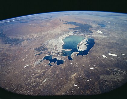 鹹海太空照圖,北方在相片下方(1997年8月)
 -
 鹹海太空照圖(2009年8月)
 -
 鹹海太空照圖,東部盆地為大量融雪淹沒(2010年8月)
 -
 鹹海太空照圖,東部盆地水分已完全消失(2014年8月)
 -
 鹹海太空照圖(2017年8月)
 -
 鹹海太空照圖(2018年4月)

_NASA_STS085-503-119.jpg)


.jpg)
對環境、經濟、和公共衛生的影響
鹹海被認為是種生態系統崩潰的例子。[35]鹹海和河流入海三角洲的生態系統幾乎被破壞殆盡,這不僅是因為鹽度高的緣故。不斷退縮的海域留下巨大的平原,上面覆蓋著鹽,以及在沃茲羅日傑尼耶島上做生化武器測試和工農業產生有毒的化學物質。由於水源減少,以及隨之而來的水以及土壤品質的惡化,自1960年代開始,越來越多棉花田地使用殺蟲劑來維持棉花生產,更進一步增加水中毒素(譬如DDT)。[36]此外,來自工業有毒的多氯聯苯化合物和重金屬也讓水和土壤受到污染。[37]
由於鹹海水量減少,這些污染物在水和土壤中的濃度都急劇增加。這些物質形成隨風散佈的毒塵,遍布整個區域。生活在鹹海附近的人透過飲用水和吸入粉塵,而與污染物接觸。[38]此外,由於飲用水受到污染,毒素已經進入食物鏈。[37]結果是鹹海周圍土地遭受嚴重污染,當地居民遭受缺乏淡水,和健康問題的困擾,其中包括某些癌症和肺部疾病的高發病率。當地常見的疾病有呼吸系統疾病(包括結核病,大部分是耐藥性,和癌症)、消化系統疾病、貧血、和傳染病。肝,腎和眼睛問題也可歸咎於有毒的沙塵暴。這些都導致人口中脆弱年齡群體的高死亡率:每千名新生兒中有75人死亡,每千名孕產婦中有12人死亡。[39][40]
沙塵暴還通過鹽分沉積而導致水危機。[41]農藥在農作物上過度使用以保持單位產量,讓情況惡化,有如雪上加霜,農藥使用程度遠超過健康允許的極限。[41]這個地區的農作物因土地有鹽分沉積而遭到破壞,農民每天至少用水沖洗田間四次,企圖把土壤中的鹽分和毒素沖走。[41]土地正在衰敗中,除草料外幾乎沒有其他農作物可以生長,哈薩克農民因此被迫只能生產草料。[42]大片水域,譬如說之前的鹹海,可以通過濕度、調節熱能及反射率來緩和當地的氣候。[43]鹹海中的水分流失把地表溫度和風向改變。導致夏天更熱,冬天更冷(估計冷熱兩方向的溫差在攝氏2度到6度之間),同時也導致當地,還有區域沙塵暴出現。[43]
魚產與舊有產業
鹹海捕撈業遭到破壞,這個行業在鼎盛時期曾僱用約40,000人,據說生產曾達到蘇聯整個漁獲量的六分之一。在1980年代,商業捕撈變得無法持續,到1987年,商業捕撈已不復存在。由於海平面下降,鹽度變得過高,以至於20種本地魚類無法存活。比目魚是唯一能夠在高鹽度條件下生存的魚。由於海平面下降,沿著前海岸的原有漁鎮已成為船舶墳場。[44]
阿拉爾最初是主要的漁港,如今距海水遠達幾公里,自湖面縮小危機爆發以來,人口急劇減少。[45]烏茲別克的木伊那克鎮曾擁有蓬勃的港口和漁業產業,有約30,000從業人員;[46]現在城鎮距海岸數公里。漁船散落在曾被海水淹沒的土地之上,許多已放置了20年。
南鹹海仍然太鹹,除耐鹽生物以外,其餘皆無法存活。[47]自從1990年代後期,原較為耐鹽的比目魚也因鹽度過高而死亡,此地已無魚類存在。[30]
在阿姆河和錫爾河兩條河的三角洲,誘捕麝鼠的產業也被摧毀,過去曾有每年產出多達500,000條毛皮的記錄。[30]
-
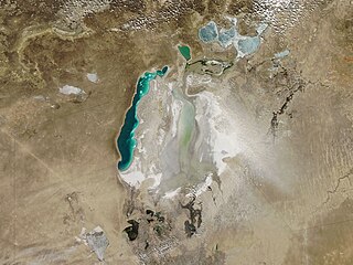 鹹海的沙塵暴(2010年3月)
 -
 哈薩克,鹹海邊被拋棄的船舶
 -
 昔日阿拉爾港口
 -
 哈薩克漁民處理當日捕撈所得。


脆弱人口群體
婦女和兒童在這環境惡化危機中,因為飲用高度污染和鹽化的水,加上乾涸的海床,成為最脆弱的群體。[48]在當地母親的血液和母乳中發現有農藥毒素,特別是有機氯化合物、多氯聯苯、DDT和TCDD(戴奧辛毒素)。[49][37]這些毒素可以,並且經常透過母親傳給孩子,導致生產低體重兒和異常兒。這個地區嬰兒出生異常的比率是歐洲國家的五倍。[50]鹹海地區兒童出生時有26%體重偏低,這與世界衛生組織收集的國際參考人群相比,有兩個標準差的差異。[51]
上述的婦女和兒童也有其他的健康問題,當地兒童腎小管功能障礙的罹患率極高,已成為主要的健康問題。腎小管功能障礙也可能與生長和發育遲緩有關聯。[52] 高比率的低出生體重兒和異常兒,對兒童造成嚴重的負面健康影響,而鹹海地區也缺乏衛生基礎設施以及資源,來應對已發生的問題。[53]
貧困者還特別容易受到鹹海變化對環境和健康造成的影響。這些人口最有可能居住在流域下游,和以前的沿海社區。他們也是這個地區至少440萬人中首先受害的一群。在這些健康情況最差的地區,當海水減少和許多水生物種的喪失,使他們的漁業生計消失,他們的困境加劇。[54]這些處於貧困之中的人們,陷入惡性循環。
解決方案
可能方案
多年來,針對這些問題有許多解決方案被提出,可行性和執行成本各不相同,包括:
- 改善灌溉渠道品質
- 使用用水較少的替代棉花品種[55]
- 促進河流上游國家非農業經濟發展[56]
- 施用較少棉花作物藥品
- 種植棉花以外的農作物
- 重新導引窩瓦河、鄂畢河、和額爾齊斯河的河水,在20-30年內將鹹海恢復到以前的規模(需要經費300-500億美元)[57]
- 通過管道從裏海引導海水,泵入鹹海,並使用當地集水區淡水把鹹海海水稀釋[58]
-03.jpg)
哈薩克、烏茲別克、土庫曼、塔吉克以及吉爾吉斯5國在1994年1月簽署一項協議,承諾提供他們國家預算中的1%來幫助鹹海復原。
2000年3月,聯合國教育、科學及文化組織在海牙舉行的第二屆世界水資源論壇上提出“迄2025年對鹹海流域與水資源有關的願景”[59]。批評者指這份文件制定的目標不切實際,並且對之前的鹹海沿岸周圍地區的利益未給予足夠的重視,等於是暗中把鹹海及住在烏茲別克湖區的人們棄之不顧。[60]到2006年,世界銀行提出恢復鹹海的項目,根據新聞報導,對於住在北鹹海區域的人曾燃起短暫希望。[61]
恢復策略
技術
透過聯合國開發計劃署負擔部分經費,在哈薩克使用雷射平整儀整平耕地,便利灌溉,以及改種耗水較少作物方面已顯示出成效。[62]
鹹海流域計劃
哈薩克、烏茲別克、塔吉克、吉爾吉斯、和土庫曼5國為解決問題,於1994年通過「鹹海流域計劃」(簡稱為ASBP-1)。[63]這個計劃具有
第一階段實際上從1992年開始,世界銀行首度在那年參與,並一直運行到1997年。後有第二階段,第三階段。在2002年又制定ASBP-2,從2003年開始執行,在2009年制定ASBP-3,繼續施行。
北鹹海修復工作


目前所做的是恢復部分北鹹海的工作。錫爾河灌溉工程已獲得修復和改善,水流量增加。哈薩克政府於2003年10月宣布興建分隔鹹海南北兩邊的鋼筋混凝土科卡拉爾大壩,於2005年8月完成,從那時起,北鹹海水位上升,鹽度下降。截至2006年,海平面恢復所需時間比預期的來得早。[64]“大壩使小鹹海(即北鹹海)的海深從不超過30公尺(98英尺)的低點迅速上升到38公尺(125英尺),他們認為上升到42公尺(138英尺)的深度可達成。”[65]
具有經濟價值的魚群已經返回,那些因當地環境災難而將北鹹海視為無藥可救的觀察員,對於這種意想不到的報告感到驚訝,報告稱,在2006年因海水重新累積,已開始振興部分漁業,捕撈漁獲物甚至可以外銷,遠到烏克蘭。捕撈業的改善主要是由於海水的平均鹽度從每公升30公克降低到8公克。鹽度下降後促使接近24種淡水物種返回。[44]據報導,北鹹海的修復工作還引起當地長期所缺乏的雨雲,和微氣候變化的可能,給受到區域性沙塵之害的農業帶來一絲希望,還有原已縮小的海域有擴充的可能。[66]
“鹹海已從哈薩克原有的港口城市阿拉爾往南退缩近100公里(62英里),現在退縮距離降到僅25公里(16英里)。”哈薩克外交部指出:“北鹹海的面積從2003年的2,550平方公里(980平方英里)增加到2008年的3,300平方公里(1,300平方英里)。海的深度從2003年的30公尺(98英尺),而在2008年已達到42公尺(138英尺)。“[2]根據世界銀行向哈薩克提供的貸款,將建設第二座大壩,該工程最初定於2009年開工,但推遲至2011年,以進一步把縮小的北鹹海擴大。[67][與來源不符]最終會把海岸線離開阿拉爾的距離,縮短到僅6公里(3.7英里)。之後將計劃修建一條橫跨最後6公里的運河,將目前已經萎縮的阿拉爾港與鹹海重新連接。[68]
根據2020年的新聞報導,第二階段實際上是延遲到2019年才又重新開工。[69]
南鹹海前景
南鹹海(其中一半位於烏茲別克)則遭到遺棄,任其自生自滅。烏茲別克鹹海的大部分地區完全乾涸,成為為平地。僅週期性有來自北鹹海的多餘海水,通過堤壩的水閘流向南鹹海。[70]目前曾進行討論,把北鹹海和乾燥的南部之間建立一條新的通道,以及尚不明確的讓整個地區濕地恢復計劃,但政府的政治意願並不高。[64]烏茲別克與已恢復境內部分的鹹海的哈薩克做法不同,並無放棄利用阿姆河河水灌溉棉花田的跡象,並有在乾涸的南鹹海海床進行石油勘探的計劃。[68]
為減輕沙漠化的負面影響,包括嘗試在新暴露的海床種植植被,但東部盆地的間歇性洪水可能對任何嘗試都會造成問題。把灌溉所餘的少量河水由阿姆河轉移到南鹹海的西部盆地,或許可拯救那裡的漁業,同時又可把東部盆地的洪水水患減輕。[71]
執行機構
哈薩克斯坦、吉爾吉斯、塔吉克、土庫曼、和烏茲別克5國於1992年2月18日成立中亞國際水資源協調委員會(Interstate Commission for Water Coordination of Central Asia,ICWC),以期聯合解決鹹海地區的環境,以及社會經濟問題。ICWC責成錫爾河和阿姆河的流域水資源組織(Basin Water Organization)協助管理水資源。[72]
ICWC於1993年3月23日成立國際拯救鹹海基金(International Fund for Saving the Aral Sea (IFAS) ),宗旨是為鹹海流域各種項目籌集資金,供拯救鹹海,和改善與因鹹海乾涸而引起環境的問題。這個基金在各國首腦會議,以及從世界銀行那裡取得經費方面,取得些許成功,但在例如執法問題,和進度趨緩的問題上仍有許多挑戰。[73]
沃茲羅日傑尼耶島

沃茲羅日傑尼耶島位在南鹹海。由於鹹海不斷縮小,它在2001年年中首先成為半島,最後與大陸土地合為一體。[74]其他島嶼,例如科卡拉爾島和巴爾薩-凱爾梅斯島也有相似情況。自從2008年東南鹹海(即南鹹海的東部)消失後,沃茲羅日傑尼耶島已無島嶼特徵。島嶼地區土地現由哈薩克和烏茲別克兩國共有。
1948年,蘇聯在這之前原為鹹海上的島嶼建立一個極為機密的生化武器實驗室,現在這裡是位於哈薩克和烏茲別克兩國間有領土糾紛的地方。這個實驗室的確切歷史、功能、和當前狀態清仍然沒人清楚,但在那裡測試出來的的生物製劑包括炭疽桿菌、貝氏考克斯菌、土拉弗朗西斯菌、豬布魯氏菌、Prowazekii立克次氏體、天花、鼠疫桿菌、肉毒桿菌毒素、和委內瑞拉馬腦炎病毒。[75]
來自該島的生化武器化的天花,在1971年污染到附近的一艘船,然後這種病毒傳播到港口城市阿拉爾。有10人受到感染,其中3人死亡,隨後當局為當地50,000名居民進行大規模的疫苗接種工作(請參考鹹海天花事件)。蘇聯在1991年解體,這個生化武器基地在1992年遭到廢棄。科學考察證明,這裡曾經是生產、測試、和隨後傾倒生化武器的地點。美國在2002年組織一個項目,並透過烏茲別克協助,對10個炭疽桿菌埋藏地點進行除污淨化工作。據哈薩克檢疫和人畜共患病感染科學中心(Kazakh Scientific Center for Quarantine and Zoonotic Infections)稱,所有炭疽桿菌埋藏地點的除污淨化工作均已完成。[76]
油氣勘探
烏茲別克副總理爾伽許· 賽伊斯瑪托夫在2006年8月30日宣布,烏茲別克政府與國際財團(由國有的烏茲別克石油公司、盧克石油海外公司、馬來西亞國家石油公司、韓國國家石油公司、和中國石油天然氣集團組成)對於鹹海油氣勘探和開發,達成生產共享協議,協議說:“人們對於鹹海尚有許多未知之處,在探得油氣方面,雖說有風險,但希望很大。我們相信這個獨特項目有成功的機會。”財團在2005年9月組成。[77]
截至2010年6月1日,已在這個地區3公里深度之處,開採出500,000立方公尺的天然氣。[78]
與鹹海有關的影片
蘇聯導演德米特里·斯維托扎洛夫(Dmitri Svetozarov)在1989年執導的電影《狗(俄語:Psy)》中對鹹海海岸的困境有所描述。[79]這部影片在鹹海附近一處真實的鬼鎮所拍攝,片中有廢棄建築物,和船隻散落四處的場景。
在2000年,MirrorMundo基金會製作一部紀錄片,名為Delta Blues(影片全名:Delta Blues (In a Land of Cotton)),講述由於海洋乾涸而引起的問題。[80]
2007年6月,英國廣播公司世界新聞頻道播放一部名為《從崩潰邊緣復原?(Back From the Brink?)》的紀錄片,製作人為Borna Alikhani和Guy Creasey,描述自科卡拉爾大壩竣工以來,這個地區發生的變化。
塔吉克導演巴克特·亞胡都那扎羅夫在2012年執導電影《等待大海(Waiting for the sea)》講述鹹海的情況,對一個海邊漁鎮人們生活產生的影響。
2012年,克里斯托弗·帕索(Christoph Pasour)和阿爾弗雷德·迪堡(Alfred Diebold)製作一部長達85分鐘的電影,標題為“從冰川到鹹海(From the glaciers to the Aral Sea)”,展示鹹海流域的水資源管理系統,尤其是鹹海流域周圍的情況。這部影片於2012年在法國馬賽舉行的第六屆世界水資源論壇上首映,現可在網站:www.waterunites-ca.org [81],以及Alfred Diebold的YouTube頻道:waterunitesca上觀賞。[82]
2013年10月,半島電視台製作一部紀錄片,片名《湖邊的人們(People of The Lake)》,由恩薩爾·阿爾泰(Ensar Altay)執導,描述鹹海目前的狀況。[83]
2014年,導演Po Powell在哈薩克和烏茲別克交界處的鹹海遺跡附近,拍攝一部平克·佛洛伊德的單曲 “Louder than Words(勝過言語”的MTV。[84]
英國廣播公司於2018年10月製作一個名為“時尚骯髒的秘密(Fashion's Dirty Secrets)”的節目,其中很大部分顯示鹹海萎縮的現象,及其所產生的後果,片中包含有一絲對未來的希望。[85]
參見
- 乾涸中湖泊清單
- 科卡拉爾大壩
- 死海
- 美索不達米亞沼澤地排水–伊拉克類似引水改流工程
- 乍得湖
- 索爾頓湖
- 錫斯坦盆地–瀕臨崩潰的阿富汗和伊朗大型濕地生態系統
- 蘇德沼澤(Sudd)–非洲一個大沼澤地,另一個計劃中的大型排水項目所在地
- 圖萊里湖-加利福尼亞州最大的湖泊,在1880年至1970年之間乾涸
參考文獻
- ^ 1.0 1.1 DRAINAGE BASIN OF THE ARAL SEA AND OTHER TRANSBOUNDARY SURFACE WATERS IN CENTRAL ASIA (PDF). United Nations Economic Commission for Europe (UNECE). 2005 [4 February 2016].
- ^ 2.0 2.1 2.2 The Kazakh Miracle: Recovery of the North Aral Sea. Environment News Service. 1 August 2008.
- ^ 日本太空署 - South Aral Sea shrinking but North Aral Sea expanding
- ^ Aral Sea | Definition of Aral Sea in English by Lexico Dictionaries.
- ^ Philip Micklin; Nikolay V. Aladin. Reclaiming the Aral Sea. Scientific American. March 2008 [17 May 2008]. (原始内容存档于2019-12-11).
- ^ Satellite image, August 16, 2009 (click on "2009" and later links). 24 September 2014 [2020-03-13]. (原始内容存档于2009-05-21).
- ^ Liston, Enjoli. Satellite images show Aral Sea basin 'completely dried'. The Guardian (London: Guardian News and Media Limited). 1 October 2014 [1 October 2014]. (原始内容存档于2020-03-25).
- ^ Stephen M Bland. Central Asia Caucasus. stephenmbland.com. [2020-03-13]. (原始内容存档于2017-11-15) (英语).
- ^ Aral Sea Reborn. Al Jazeera. 21 July 2012 [6 January 2013]. (原始内容存档于2020-03-25).
- ^ Daily Telegraph. Aral Sea 'one of the planet's worst environmental disasters'. The Daily Telegraph (London). 5 April 2010 [1 May 2010]. (原始内容存档于2010-04-08).
- ^ About travel to Aral Sea. [29 August 2016]. (原始内容存档于2020-03-10).
- ^ Syr Darya river, Central Asia. Encyclopedia Britannica. [2020-03-13]. (原始内容存档于2020-03-25) (英语).
- ^ Middleton, Nick; "The Aral Sea" in Shahgedanova Maria; The Physical Geography of Northern Eurasia; pp. 497-498
- ^ Velichko, Andrey and Spasskaya, Irina; "Climatic Change and the Development of Landscapes" in Shahgedanova Maria; The Physical Geography of Northern Eurasia; pp. 48-50
- ^ 15.0 15.1 Aladin, Nikolay Vasilevich; Gontar, Valentina Ivanovna; Zhakova, Ljubov Vasilevna; Plotnikov, Igor Svetozarovich; Smurov, Alexey Olegovich; Rzymski, Piotr; Klimaszyk, Piotr. The zoocenosis of the Aral Sea: six decades of fast-paced change. Environmental Science and Pollution Research International. 2019, 26 (3): 2228–2237. ISSN 0944-1344. PMC 6338704
 . PMID 30484051. doi:10.1007/s11356-018-3807-z.
- ^ Cretaux et. al 2013, pp. 100, 105-106
- ^ Cretaux et. al 2013, pp. 103
- ^ Boroffka 2010, pp. 295
- ^ Li, Shi. The History of Customs in Sui, Tang and Five Dynasties. 2019. 已忽略未知参数
|https://books.google.com.tw/books?id=(帮助) - ^ Gan, Chunsong. A Concise Reader of Chinese Culture. 2019: 24. ISBN 9789811388675.
- ^ 21.0 21.1 Valikhanov, Chokan Chingisovich; Venyukov, Mikhail Ivanovich. The Russians in Central Asia: their occupation of the Kirghiz steppe and the line of the Syr-Daria: their political relations with Khiva, Bokhara, and Kokan: also descriptions of Chinese Turkestan and Dzungaria. Translated by John Michell, Robert Michell. London: Edward Stanford. 1865: 324–329.
- ^ Rich, David Alan. The Tsar's colonels: professionalism, strategy, and subversion in late Imperial Russia. Harvard University Press. 1998: 247. ISBN 0-674-91111-3.
- ^ Soviet cotton threatens a region's sea - and its children. New Scientist. 18 November 1989 [27 January 2010]. (原始内容存档于2015-04-26).
- ^ USDA-Foreign Agriculture Service. Cotton Production Ranking. National Cotton Council of America. 2013 [14 October 2013]. (原始内容存档于2019-04-20).
- ^ 25.0 25.1 Cotton production linked to images of the dried up Aral Sea basin. The Guardian. 1 October 2014 [2020-03-13]. (原始内容存档于2020-03-25).
- ^ The True Costs of Cotton: Cotton Production and Water Insecurity (PDF). Environmental Justice Foundation (EJF). [2020-03-13]. (原始内容存档 (PDF)于2020-08-17).
- ^ Uzbekistan in Numbers 2006, State Statistical Committee of the Republic of Uzbekistan, Tashkent, 2007 (俄文).
- ^ ca-water.net, a knowledge base for projects in the Central Asia. 2003 [1 November 2010].
- ^ Micklin, Philip. The past, present, and future Aral Sea. Lakes & Reservoirs: Research & Management. December 2017, 15 (3): 193–213. doi:10.1111/j.1440-1770.2010.00437.x.
- ^ 30.0 30.1 30.2 Michael Wines. Grand Soviet Scheme for Sharing Water in Central Asia Is Foundering. The New York Times. 9 December 2002 [8 March 2008]. (原始内容存档于2009-02-11).
- ^ Bissell, Tom. Eternal Winter: Lessons of the Aral Sea Disaster. Harper's. 2002: 41–56.
- ^ Glantz, Michael H. Creeping Environmental Problems and Sustainable Development in the Aral Sea.... Cambridge, New York: Cambridge University Press. 1999: 174 [17 May 2008]. ISBN 0-521-62086-4.
- ^ Craig Murray. Dirty Diplomacy. Scribner. 2007.
- ^ Greenberg, Ilan. A vanished sea reclaims its form in Central Asia. International Herald Tribune. 7 April 2006. (原始内容存档于22 December 2017).
- ^ Keith, DA; Rodríguez, J.P.; Rodríguez-Clark, K.M.; Aapala, K.; Alonso, A.; Asmussen, M.; Bachman, S.; Bassett, A.; Barrow, E.G.; Benson, J.S.; Bishop, M.J.; Bonifacio, R.; Brooks, T.M.; Burgman, M.A.; Comer, P.; Comín, F.A.; Essl, F.; Faber-Langendoen, D.; Fairweather, P.G.; Holdaway, R.J.; Jennings, M.; Kingsford, R.T.; Lester, R.E.; Mac Nally, R.; McCarthy, M.A.; Moat, J.; Nicholson, E.; Oliveira-Miranda, M.A.; Pisanu, P.; Poulin, B.; Riecken, U.; Spalding, M.D.; Zambrano-Martínez, S. Scientific Foundations for an IUCN Red List of Ecosystems. PLOS ONE. 2013, 8 (5): e62111 [8 September 2018]. Bibcode:2013PLoSO...862111K. PMC 3648534 . PMID 23667454. doi:10.1371/journal.pone.0062111. (原始内容存档于2020-03-25).
- ^ Whish-Wilson, Phillip. The Aral Sea environmental health crisis (PDF). Journal of Rural and Remote Environmental Health. 2002, 1 (2): 30 [17 May 2008]. (原始内容存档 (PDF)于2008-04-09).
- ^ 37.0 37.1 37.2 Jensen, S.; Mozhitova, Z.; Zetterstrom, R. Environmental pollution and child health in the Aral Sea region in Kazakhstan. Science of the Total Environment. 5 November 1997, 206 (2–3): 187–193. Bibcode:1997ScTEn.206..187J. doi:10.1016/S0048-9697(97)00225-8.
- ^ O'Hara, Sarah; Wiggs, Giles; Mamedov, Batyr; Davidson, George; Hubbard, Richard. Exposure to airborne dust contaminated with pesticide in the Aral Sea region. The Lancet. 19 February 2000, 355 (9204): 627–628. PMID 10696990. doi:10.1016/S0140-6736(99)04753-4.
- ^ Aral Sea - Aral Sea. [2020-03-13]. (原始内容存档于2009-03-16).
- ^ Mętrak M. Health and social consequences of the Aral Lake disaster. In: Chwil M., Skoczylas M.M. (red.). Contemporary research on the state of the environment and the medicinal use of plants. Lublin: Wydawnictwo Uniwersytetu Przyrodniczego w Lublinie, pp. 99-108. Accessible in: https://wydawnictwo.up.lublin.pl/e-ksiazka (页面存档备份,存于互联网档案馆)
- ^ 41.0 41.1 41.2 The Aral Sea Crisis. Thompson, Columbia University. [6 January 2013].
- ^ Saiko, Tatyana. Geographical and socio-economic dimensions of the Aral Sea crisis and their impact on the potential for community action. Journal of Arid Environments. 1998, 39 (2): 230. Bibcode:1998JArEn..39..225S. doi:10.1006/jare.1998.0406.
- ^ 43.0 43.1 McDermid, Sonali Shukla; Winter, Jonathan. Anthropogenic forcings on the climate of the Aral Sea: A regional modeling perspective. Anthropocene. December 2017, 20: 48–60. doi:10.1016/j.ancene.2017.03.003.
- ^ 44.0 44.1 Chen, Dene-Hern. Once Written Off for Dead, the Aral Sea Is Now Full of Life. 16 March 2018 [2020-03-13]. (原始内容存档于2019-07-27).
- ^ Bland, Stephen M. Kazakhstan: Measuring the Northern Aral's Comeback. EurasiaNet. 27 January 2015 [19 September 2017]. (原始内容存档于2018-06-23).
- ^ Uzbekistan: Moynaq village faces the Aral Sea disaster. UNICEF. [2020-03-13]. (原始内容存档于2017-03-10).
- ^ Aladin et al. 2018, p. 2234.
- ^ Ataniyazova, Oral. Health and Ecological Consequences of the Aral Sea Crisis (PDF). 18 March 2003 [2020-03-13]. (原始内容存档 (PDF)于2020-05-05).
- ^ Whish-Wilson, Phillip. The Aral Sea environmental health crisis (PDF). Journal of Rural and Remote Environmental Health. 2002, 1 (2): 30 [17 May 2008]. (原始内容存档 (PDF)于2008-04-09).
- ^ Ataniyazova, Oral. Health and Ecological Consequences of the Aral Sea Crisis (PDF). 18 March 2003 [2020-03-13]. (原始内容存档 (PDF)于2020-05-05).
- ^ Crighton, Eric James; Barwin, Lynn; Small, Ian; Upshur, Ross. What have we learned? A review of the literature on children's health and the environment in the Aral Sea area. International Journal of Public Health. April 2011, 56 (2): 125–138. PMC 3066395 . PMID 20976516. doi:10.1007/s00038-010-0201-0.
- ^ Kaneko, K; Chiba, M; Hashizume, M; Kunii, O; Sasaki, S; Shimoda, T; Yamashiro, Y; Caypil, W; Dauletbaev, D. Renal tubular dysfunction in children living in the Aral Sea Region. Archives of Disease in Childhood. 4 March 2003, 88 (11): 966–968 [2020-03-13]. PMC 1719339 . PMID 14612357. doi:10.1136/adc.88.11.966. (原始内容存档于2020-03-10).
- ^ Small, Ian; van der Meer, J; Upshur, Ross. Acting on an environmental health disaster: the case of the Aral Sea.. Environmental Health Perspectives. 1 June 2001, 109 (6): 547–549. PMC 1240333 . PMID 11445505. doi:10.1289/ehp.01109547.
- ^ Peachey, Everett. The Aral Sea Basin Crisis and Sustainable Water Resource Management in Central Asia (PDF). Journal of Public and International Affairs. 2004, 15: 1–20 [2020-03-13]. (原始内容存档 (PDF)于2020-09-01).
- ^ Usmanova, RM. Aral Sea and sustainable development. Water Sci Technol. 25 March 2013, 47 (7–8): 41–7. PMID 12793660. doi:10.2166/wst.2003.0669.
- ^ Olli Varis. Resources: Curb vast water use in central Asia. [Nature Vol 514(7520)]. Nature News. 2 October 2014, 514 (7520): 27–9. PMID 25279902. doi:10.1038/514027a.
- ^ Ed Ring. Release the Rivers: Let the Volga & Ob Refill the Aral Sea. Ecoworld. 27 September 2004 [17 May 2008]. (原始内容存档于2008-04-29).
|url-status=和|dead-url=只需其一 (帮助) - ^ Aral Sea Refill: Seawater Importation Macroproject. The Internet Encyclopedia of Science. 29 June 2008 [8 October 2009]. (原始内容存档于2018-04-03).
- ^ Water-related vision for the Aral Sea basin for the year 2025 (PDF). UNESCO. March 2000 [1 April 2010]. (原始内容存档 (PDF)于2011-07-28) (美国英语及俄语).
- ^ (Nederland) - UNESCO promotes unsustainable development in Central Asia. Indymedia NL. [18 July 2009]. (原始内容存档于2016-10-22).
- ^ A Witch's Brew. BBC News. July 2006 [17 May 2008]. (原始内容存档于2007-12-13).
|url-status=和|dead-url=只需其一 (帮助) - ^ Can the Aral Sea make a comeback?. UNDP Eurasia. United Nations.
- ^ Shawki Barghouti. Case Study of the Aral Sea Water and Environmental Management Project: an independent evaluation of the World Bank's support of regional programmes. The World Bank (报告). 2006 [1 November 2010]. (原始内容存档于2012-03-25).
- ^ 64.0 64.1 Ilan Greenberg. A vanished Sea Reclaims its form in Central Asia. Int. Her. Trib. 7 April 2006 [17 May 2008]. (原始内容存档于2008-05-12).
- ^ Ilan Greenberg. As a Sea Rises, So Do Hopes for Fish, Jobs and Riches. The New York Times. 6 April 2006 [16 May 2008]. (原始内容存档于2015-01-05).
- ^ Miraculous Catch in Kazakhstan's Northern Aral Sea. The World Bank. June 2006 [17 May 2008]. (原始内容存档于2016-10-17).
- ^ North Aral Sea Recovery. The Earth Observatory. NASA. 2007 [17 May 2008]. (原始内容存档于2008-08-30).
- ^ 68.0 68.1 Martin Fletcher. The return of the sea. The Times (London). 23 June 2007 [17 May 2008]. (原始内容存档于2011-06-29).
- ^ Northern Aral's promise stunted by dam height, international disputes. EURASIANET. 28 October2020 [17 June 2021].
- ^ Saving a Corner of the Aral Sea. The World Bank. 1 September 2005 [17 May 2008].
- ^ The rehabilitation of the ecosystem and bioproductivity of the Aral Sea under conditions of water scarcity (PDF). August 2007. (原始内容存档 (PDF)于2012-07-29).
- ^ Strategies suggested for implementation. ICWC. [6 January 2013]. (原始内容存档于2020-03-25).
- ^ IFAS. WaterWiki.net. [4 April 2010].[永久失效連結]
- ^ NASA Visible Earth - "Rebirth" Island Joins the Mainland (页面存档备份,存于互联网档案馆), Aral Sea (页面存档备份,存于互联网档案馆)
- ^ Bozheyeva, G., Y. Kunakbayev and D. Yeleukenov. Former Soviet Biological Weapons Facilities in Kazakhstan: Past, Present and Future. Occasional Paper 1 (Monterey, Calif.: Monterey Institute of International Studies, Center for Nonproliferation Studies). 1999.
- ^ Khabar Television/BBC Monitoring. Kazakhstan: Vozrozhdeniya Anthrax Burial Sites Destroyed. Global Security Newswire (Nuclear Threat Initiative). 20 November 2002 [17 May 2008]. (原始内容存档于2008-04-22).
- ^ Uzbekistan, intl consortium ink deal on exploring Aral Sea. ITAR-Tass. [2020-03-13]. (原始内容存档于2010-07-27).
|url-status=和|dead-url=只需其一 (帮助) - ^ Michael Hancock-Parmer. Aral Gas. Registan.net. 9 June 2010 [2020-03-13]. (原始内容存档于2010-06-11).
|url-status=和|dead-url=只需其一 (帮助) - ^ Psy. Kino Expert. [18 September 2009]. (原始内容存档于2020-03-25).
- ^ Delta Blues (in a land of cotton). YouTube. 5 November 2008 [18 July 2009]. (原始内容存档于2016-04-10).
- ^ Videos - From the Glaciers to the Aral Sea - Water Unites. www.waterunites-ca.org. [2020-03-13]. (原始内容存档于2020-03-25).
- ^ Water Unites - From the Glaciers to the Aral Sea. youtube. [2020-03-13]. (原始内容存档于2020-03-25).
- ^ Al Jazeera World. People of the Lake. [4 December 2015]. (原始内容存档于2020-03-25).
- ^ Watch Pink Floyd's Surreal, Sun-Baked 'Louder Than Words' Video. Rolling Stone. 10 November 2014 [4 December 2015]. (原始内容存档于2017-10-02).
- ^ Stacey Dooley Investigates: Are your clothes wrecking the planet? Radhika Sanghani, 9 October 2018, BBC
進一步閱讀
- Aladin, Nikolay Vasilevich; Gontar, Valentina Ivanovna; Zhakova, Ljubov Vasilevna; Plotnikov, Igor Svetozarovich; Smurov, Alexey Olegovich; Rzymski, Piotr; Klimaszyk, Piotr. The zoocenosis of the Aral Sea: six decades of fast-paced change. Environmental Science and Pollution Research International. 27 November 2018, 26 (3): 2228–2237. PMC 6338704 . PMID 30484051. doi:10.1007/s11356-018-3807-z.
- Bissell, Tom. Eternal Winter: Lessons of the Aral Sea Disaster. Harper's. April 2002: 41–56 [17 May 2008].
- Bissell, Tom. Chasing The Sea: Lost Among the Ghosts of Empire in Central Asia
 . New York: Vintage Books. 2004. ISBN 978-0-375-72754-2.
 - Borroffka, Nikolaus G.O., Archaeology and Its Relevance to Climate and Water Level Changes: A Review, Kostianoy, Andrey G.; Kosarev, Aleksey N. (编), The Aral Sea Environment, Heidelberg: Springer-Verlag: 283–303, 2010
- Cretaux, Jean-François; Letolle, René; Bergé-Nguyen, Muriel. History of Aral Sea level variability and current scientific debates. Global and Planetary Change. 2013, 110: 99–113 [8 June 2020]. doi:10.1016/j.gloplacha.2013.05.006.
- Ellis, William S. A Soviet Sea Lies Dying. National Geographic. February 1990: 73–93.
- Ermakhanov, Zaualkhan K.; Plotnikov, Igor S.; Aladin, Nikolay V.; Micklin, Philip. Changes in the Aral Sea ichthyofauna and fishery during the period of ecological crisis. Lakes & Reservoirs: Research and Management. 28 February 2012, 17 (1): 3–9. doi:10.1111/j.1440-1770.2012.00492.x.
- Ferguson, Rob. The Devil and the Disappearing Sea. Vancouver: Raincoast Books. 2003. ISBN 1-55192-599-0.
- Ryszard Kapuscinski, Imperium, Granta, 2019, ISBN 9781783785254
- Kasperson, Jeanne; Kasperson, Roger; Turner, B.L. The Aral Sea Basin: A Man-Made Environmental Catastrophe. Dordrecht; Boston: Kluwer Academic Publishers. 1995: 92. ISBN 92-808-0848-6.
- Bendhun, François; Renard, Philippe. Indirect estimation of groundwater inflows into the Aral sea via a coupled water and salt mass balance model. Journal of Marine Systems. 2004, 47 (1–4): 35–50 [17 May 2008]. doi:10.1016/j.jmarsys.2003.12.007. (原始内容存档于14 February 2008).
- Micklin, Philip. The Aral Sea Disaster. Annual Review of Earth and Planetary Sciences. 2007, 35 (4): 47–72. Bibcode:2007AREPS..35...47M. doi:10.1146/annurev.earth.35.031306.140120.
- Sirjacobs, Damien; Grégoire, Marilaure; Delhez, Eric; Nihoul, JCJ. Influence of the Aral Sea negative water balance on its seasonal circulation patterns: use of a 3D hydrodynamic model. Journal of Marine Systems. 2004, 47 (1–4): 51–66. Bibcode:2004JMS....47...51S. doi:10.1016/j.jmarsys.2003.12.008. hdl:2268/2793.
- Sun, Fangdi; Ma, Ronghua. Hydrologic changes of Aral Sea: A reveal by the combination of radar altimeter data and optical images. Annals of GIS. 14 June 2019, 25 (3): 247–261. doi:10.1080/19475683.2019.1626909 .
外部連結
- 咸海“缩水”90%潘基文称之为“地球上最令人惊讶的生态灾难”(页面存档备份,存于互联网档案馆)
- {{cite web
- Rivers Network : Aral Sea watersheds - webmap
- Post-Soviet Legacy: Aral Sea Pollution from the Dean Peter Krogh Foreign Affairs Digital Archives
- Aral Sea Foundation
- Union for Defence of the Aral Sea and Amudarya River
- Syr Darya Control & Northern Aral Sea Phase I Project. World Bank Group - Kazakhstan. December 2006.
- Aral Sea from Space (time lapse)
- Swedish Aral Sea Society
- Google Earth view of the Aral Sea
- Youtube video: stranded ships on the dry bed of the Aral Sea being broken up for scrap
| |||||||||||||||||||
| |||||||||||||||||||||||||||
| ||||||||||||||||||||||